CIESIN Thematic Guides
 Landsat Multispectral Scanner (MSS) data provide the longest duration archive (21 years) of moderately high spatial resolution satellite image data for monitoring the types and rates of land-surface change imposed by human activity. The derivation of change information from Landsat data generally consists of coregistering the data of two or more images of the same area acquired at different points in time; adjusting the radiometric properties of the data to normalize for varying observation and atmospheric conditions; implementing a change detection metric on the combined data sets; and producing an output product that can effectively convey land-surface change on an image, graphic, or statistical basis. Although the consistent data characteristics of Landsat MSS data enable ready production of change images, the procedures of change image production can also be implemented on multiple data sets of non-similar data characteristics, allowing combination of Landsat MSS data with data from other sensors, such as Landsat Thematic Mapper (TM) and Systeme Probatoire d'Observation de la Terra (SPOT).
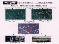
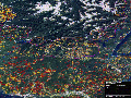
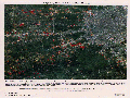
Change detection metrics generally operate by detecting numerical differences in corresponding pixel values between dates. Metrics can be applied to the inherent spectral data of the sensor or to data transformations derived from them. Figure 1 illustrates the concept of change detection using coregistered Landsat MSS satellite images. Figure 2 and figure 3 illustrate change images for a forested region and an urban fringe setting, respectively.