 CIESIN Thematic Guides
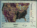
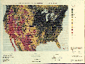
 In 1990, the U.S. Geological Survey's Earth Resources Observation Systems Data Center (EDC) initiated a program to produce a biweekly time series of Advanced Very High Resolution Radiometer (AVHRR) 1-km data sets for the conterminous United States, as Eidenshink (1992) describes in "The 1990 Conterminous U.S. AVHRR Data Set." The data sets, produced on an annual basis, now exist for the years 1989 to present. Each annual data set is comprised of continuous biweekly maximum Normalized Difference Vegetation Index (NDVI) composited data sets for the months of March through October, with an additional biweekly composited data set for each of the months from November through February. Each biweekly composite is comprised of 10 coregistered images that include the maximum NDVI greenness value for each pixel area during the compositing period. Figure 1 and Figure 2 show color-coded NDVI greenness values for biweekly data sets of the 1990 growing season from April 27 to May 10 and from July 20 to August 2, respectively.
All annual AVHRR 1-km composited data sets of the conterminous United States are available on CD-ROM from EDC. The U.S. Geological Survey's Global Land Information System (GLIS) provides information on the characteristics and availability of Conterminous U.S. AVHRR data.
The availability of repetitive AVHRR 1-km data sets over extensive regions has spurred research efforts to use the data sets for the regionalization and characterization of land cover. In "Development of a Land Cover Characteristics Database for the Conterminous U.S.," Loveland et. al. (1991) describe development of a prototype database through the joint use of the 1990 time series AVHRR 1-km composited data sets and ancillary data including elevation, climate, ecoregions, and land resource areas. The database includes seasonal land-cover regions and corresponding attributes of land characteristics, including vegetation components, seasonal properties, spectral properties, elevation, soils, and climate. The data set is available on CD-ROM from EDC. The Global Land Information System (GLIS) product announcement Conterminous U.S. Land Cover Characteristics Data on CD-ROM provides further information.