 CIESIN Thematic Guides
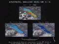
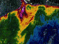
 Natural scientists have developed many types of data transformations to assist the derivation of geophysical information and other physical properties associated with water. Figure 1 illustrates thermal patterns of water in the Chernobyl Nuclear Powerplant cooling pond just before, during, and after the crisis associated with the burning reactor in 1986. Figure 2 shows varying concentrations of sediment in the Gulf of Thailand at the mouth of the Chao Phraya River and Figure 3 shows computed water depth along the Buen Hombre Coast of the Dominican Republic.
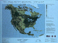
A major subgroup of transformations, known as vegetation or "greenness" indices, have been developed for evaluating vegetative land cover. Of these, the Normalized Difference Vegetation Index (NDVI) has become most widely used for analysis of vegetation type, amount, and condition. Goward, Tucker, and Dye (1985) describe how continental-scale NDVI of coarse spatial resolution provides information about global vegetation distribution and dynamics useful in studies of biomass production, land surface hydrology, carbon sequestering, and CO2 and other trace gas exchange in "North American Vegetation Patterns Observed with the NOAA-7 Advanced Very High Resolution Radiometer." More recently, computer processing capabilities have advanced to enable the production of continental-scale NDVI data products at 1-km spatial resolution, as illustrated in Figure 4. Loveland et al. (1991) use an annual sequence of 1-km NDVI values to digitally stratify and classify spectral-temporal categories of vegetation in "Development of a Land-cover Characteristics Database for the Conterminous U.S."
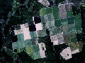
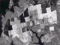
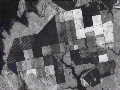
Another major subgroup of transformations, the Tasseled Cap transforms, involves computations of hybrid dimensions within the satellite image data space, with each new dimension defined by pre-determined weighted sums of the original complement of spectral bands. These types of rotational transformations amount to adjustments of the viewing perspective into multidimensional data space to allow the internal concentrations of data to be more obvious. Crist, Laurin, and Cicone (1986) describe how these transformations provide a set of variables that are directly associated with geophysical properties of the terrain surface in scenes dominated by vegetation and soil in "Vegetation and Soils Information Contained in Transformed Thematic Mapper Data." Such variables include brightness (overall reflectance), greenness (presence and density of vegetation), and wetness (influenced by soil moisture and vegetation density). Figure 5 is a normal color image of agricultural fields in North Carolina produced from Landsat Thematic Mapper data. Figure 6 and figure 7 are images of scene brightness and greenness, respectively, for the same fields computed by the Tasseled Cap Transform.
These data transformations can likely aid the derivation of information from satellite images for social scientists. For example, sequential use of a greenness transform in agricultural regions may aid the discrimination of crops or enhance the determination of production success, factors that may be associated with human dimensions interests such as farm capability or farm income. Repeated use of the greenness transform over time will contribute consistent information to studies of the social and economic viability of the regions.
Prospects also exist for developing new data transformations to enhance land-surface properties associated with evidence of specific human activities. Recent development of a transformation using the shortwave infrared spectral regions of Landsat Thematic Mapper data enables estimating the amount of crop residue remaining in agricultural fields prior to planting (Colwell et. al.1992). Figure 8 illustrates changes in crop residue for an agricultural region in central Michigan. Where social and economic driving forces of change are at work, this type of transformation could be used to monitor conversion of tillage practices from traditional cultivation to no-till. Transformations may be possible for enhancing land-surface properties associated with concentrations of human habitation, such as various surfaces in urban areas or denuded and compacted soils caused by overgrazing adjacent to rural settlements.
 ..
..