CIESIN Thematic Guides
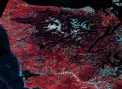
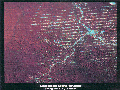
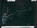
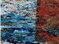
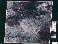
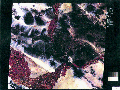
 The global coverage offered by satellite image products can provide a useful perspective for designing and implementing a globally coordinated research approach to studying selected human dimensions driving forces of global change. Satellite images enable consistent visual observation of the effects of human activities in widely different geographic regions. For example, Figure 1 and figure 2 illustrate very different patterns of human alteration of forest cover in the U.S. Pacific Northwest and Brazil, respectively. Such observation is useful for initially characterizing global variations in selected human activities and for determining their overall regional levels of occurrence and distribution. Satellite images also enable assessing the impact of natural, political, management, or other administrative boundaries on landscape conditions. Figure 3 shows the effect of the Rio Abuna along the border between Brazil and Bolivia for containing forest alternation activities; figure 4 illustrates the extent to which Mexican homesteaders have cleared forests across the border in Guatemala; figure 5 shows differences in the extent of land cultivation on either side of the border between Canada and Montana; and figure 6 illustrates differences in agriculture in the Imperial Valley on either side of the border between the United States and Mexico. Thus, satellite image observations facilitate identifying similar environments, which may or may not show evidence of human activity causing changes, or identifying different environments being subjected to similar types of human activity.