CIESIN Thematic Guides
Knowledge Transfer Products
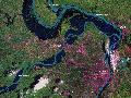
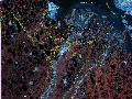
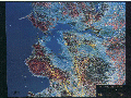
The pictorial portrayal of the landscape presented by satellite image products provides a generally comprehensible medium for conveying information on human dimensions activities to policymakers, educators, and the general public. The consistent image properties of a selected sensor system enable comparing and contrasting variations in human activities around the world. Satellite image map products can be effective for documenting the impacts of human activity on the landscape and can also convey the results of human dimensions research that may involve an integrated spatial analysis of variables in a geographic information system (GIS). The results might show, for a selected type of human activity, the historical development (directions and rates of spatial expansion), relationships to land characteristics (physical geography or ownership), or the influence of other interacting driving forces. Figures 1-5 illustrate examples of the use of satellite images for conveying human-related information. Figure 1 shows the spatial and temporal pattern of logging activity in the U.S. Pacific Northwest; figure 2 illustrates a perspective-view image of the logging activity; figure 3 shows locations and magnitudes of earthquakes in the San Francisco area for 1972 to 1989; figure 4 illustrates a portion of the U.S. Midwest at the peak of the record-breaking 1993 flood; and figure 5 shows human incursion into the Prudhoe Bay region of Alaska's North Slope during the oil development period of 1974 to 1986.
Figures 1 - 3
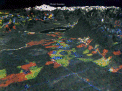
Figures 4 & 5