CIESIN Thematic Guides
 The Advanced Very High Resolution Radiometer (AVHRR) sensor is carried on-board the National Oceanic and Atmospheric Administration's (NOAA) series of Polar-Orbiting Operational Environmental Satellites (POES). A prototype AVHRR sensor as developed and first launched in October 1978 to acquire meteorological data, including day and night cloud mapping, surface water delineation, and sea surface temperatures. The next AVHRR sensor, launched on the NOAA-6 satellite in June 1979, included a redefined visible spectral band. The Figure of Observation Characteristics illustrates that the redefined band eliminates an overlap with a near-infrared band and corresponds more closely with the red absorption region of vegetation. This development heralded the additional use of the AVHRR as a vegetation mapping and analysis tool by enabling the acquisition of data suitable for use in a computed Normalized Difference Vegetation Index (NDVI).
AVHRR data are acquired with a wide-field scanning system that enables global coverage on a daily basis with a ground resolution of 1.1 km at nadir (directly beneath the satellite). The sensor also provides a data stream of nominal 4-km resolution that is achieved by sampling and averaging the full resolution 1.1-km data on-board the satellite. The U.S. Geological Survey's Global Land Information System (GLIS) provides information on Advanced Very High Resolution Radiometer data characteristics and availability.
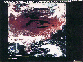
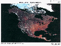
AVHRR data characteristics and capabilities make them useful for land-cover studies of extensive regions. Figure 1 illustrates an acquisition of a single orbital pass over the North American Continent. Such coverage enables production of continental scale mosaics, as depicted in figure 2. In "Applications of NOAA AVHRR 1-km Data for Environmental Monitoring," Ehrlich, Estes, and Singh (1994) provide a literature review and examples of use of AVHRR data for stratifying and mapping vegetation and monitoring changes at regional, continental, and global scales. In "Fire Detection Using Data from the NOAA-N Satellites," Matson, Stephens, and Robinson (1987) report use of the AVHRR for monitoring biomass burning on a global scale. Gallo et al. (1993) use AVHRR data to assess the urban heat island effect in "The Use of NOAA AVHRR Data for Assessment of the Urban Heat Island Effect."