 CIESIN Thematic Guides
 Image stratification at the local and regional level serves to direct field data collection efforts to areas where they are most appropriate. Social scientists can use the geographical distribution of anthropogenically induced land surface conditions or other physical land characteristics to direct their acquisition of primary social science data and to assist the extrapolation of results. Thus, local and regional research studies will be optimally located in their evaluation of selected human activities. If the methodologies of local and regional studies are coordinated on a global scale, the results will be more conducive to global comparison and aggregation.
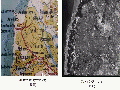
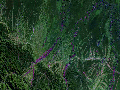
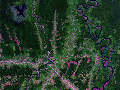
Satellite images can aid the physical acquisition of field data in several ways. The locations and arrangement of areal strata provide a spatial framework for directing the allocation of resources and efforts for more efficient collection of data (e.g., siting base areas to work from, routes of travel, and areas of concentrated survey activities). Satellite images enable verification or update of cartographic map data, as shown in Figure 1, while collecting field data (e.g., confirming or locating new roads or settlements). Satellite images have also been shown to facilitate the field survey interview process by serving as a visual reference when interviewing knowledgeable individuals about location and size of activities, and for checking the credibility of interview responses from indigenous persons. Figure 2 illustrates a synoptic view of forest alteration activities in Bolivia.Figure 3 illustrates the great detail that can be preserved in extreme enlargements of high resolution satellite images, making them useful as image maps for field survey interview work. Thomas and Roller (1993) discuss this use in "CIESIN's Experiences with Integrated Global Change Research."
Perhaps most importantly, the synoptic overview of landscape conditions at the local and regional level provided by satellite images can be used as a common frame of reference to facilitate identifying natural science data variables for subsequent joint analysis with social science data. Stratification of regions according to these joint considerations will create distinct areas in which to acquire information about human activities and the ecophysical context in which they occur. As human and natural science data are gathered on common areas, they are inherently integrated in space and time. CIESIN (1993) reports in CIESIN 1991 Science Pilot Project Program, that they received a testament describing this particular use of satellite images from a multidisciplinary team of scientists involved in field data collection efforts contributing to an integrated study of deforestation in Madagascar (Kottak et al. 1991). The scientists stated that examination of satellite images and comparison of the social and natural science data being collected jointly in the field contributed to new insights and better interdisciplinary understanding among all team members.