 Reproduced, with permission, from:
Lanly, J. 1982. Tropical forest resources. Food and Agriculture Organization of the United Nations (FAO) paper no. 30. Rome: Food and Agriculture Organization of the United Nations.
Reproduced, with permission, from:
Lanly, J. 1982. Tropical forest resources. Food and Agriculture Organization of the United Nations (FAO) paper no. 30. Rome: Food and Agriculture Organization of the United Nations.
In accordance with their mandate and the recommendations of the statutory bodies, FAO and UNEP have undertaken to reassess the present situation and current development of the forest resources throughout the tropical world, within the framework of the Global Environment Monitoring System (GEMS). The FAO/UNEP Tropical Forest Resources Assessment Project, signed on 8 November 1978 by both organizations, started on 1 December 1978 and was completed in June 1981. The findings of this important survey are presented in four technical reports. The first three reports deal with the tropical areas of America, Africa, and Asia respectively; each report consists of a regional synthesis (in Spanish for the Latin American area, in French and English for Africa, and in English for Asia), together with a collection of monographs, country by country, in the official language used for communication between each country and FAO. This fourth report collates all the findings obtained in one overall synthesis for the tropical world.
This survey has consisted essentially of the organization, interpretation, and treatment, country by country, of the vast mass of data collected, within a single simple framework of classifications and concepts. In 13 of the 76 countries surveyed, an interpretation of satellite images has provided a certain amount of additional area data which have been combined with information supplied from other sources. A dialogue has been established between FAO and the forestry departments of the countries concerned, inviting them in particular to look over the first draft of the assessment. In three countries (Peru, India and Burma) the major part of the work has been carried out directly by national institutions of each country.
The following overall data give an initial coverage of the present situation and of the development of tropical forestry resources. The 76 countries surveyed cover a total area of 4 814 million hectares, that is more than 97% of the total area of the countries which for the most part lie in the belt between the tropics or which are subject to a tropical monsoon climate. In 1980 this total area comprised approximately 1 200 million hectares of closed forest (97% broadleaved) and 735 million hectares of open tree formations, which are essentially mixed broadleaved forest - grassland tree formations. To this must be added 410 million hectares of "forest fallow" (that is to say, patchworks of various succession stages of tree formations resulting from clearing by shifting agriculture, including corresponding crop areas) and finally 625 million hectares of shrubland, some altered by agriculture and some not. In 1980, the closed forests which had not yet been touched by logging covered some 990 million hectares overall of which a little less than 675 million hectares of productive forest are untouched, 275 million hectares which are unproductive forests because of stand and terrain characteristics, and finally about 41 million hectares situated inside national parks or equivalent reserves. Approximately 210 million hectares of productive closed forests remain which have been logged over; but only 42 million hectares of this are under intensive management (and more than three quarters of this area within a single country), whilst the rest (that is to say, nearly 170 million hectares) are still in a condition of logged-over forest as yet not subjected to regular management and often destined to be cleared for agricultural use in the near future. About 4.4 million hectares of productive closed forest not hitherto touched (or 0.65% of the total area) are opened up each year to logging; as a rule this process is much more selective in America and in Africa than in Asia, where forests contain a high proportion of marketable timber.
About 7.5 million hectares of closed forest and 3.8 million hectares of open tree formations are cleared each year in order to allow the land to be used for other purposes, usually agricultural. About 45% of such reduction, as far as closed forests are concerned, can be ascribed to shifting cultivation. But to this process of deforestation sensu stricto must be added the numerous kinds of degradation of the woody component of the open tree formations, generally resulting from overexploitation (mainly for fuelwood), overgrazing, and repeated burning. The damage caused by these traditional practices, which are now becoming excessive by reason of population pressure and lack of proper management, either remains constant or is even increasing generally, thus causing a gradual loss of productivity and an irreversible degradation of the other segments of the ecosystems (notably the soil).
The creation of new resources by forest plantation establishment is far from making up for the losses caused by clearing or by the degradation of natural forest ecosystems, both in area and growing stock. At the end of 1980, there were altogether about 11.5 million hectares of industrial and non-industrial plantations in the 76 countries surveyed, and this area is increasing at an annual rate of 1.1 million hectares. Although this rate has greatly accelerated over the last ten years and should continue to increase, the ratio between areas planted and areas of closed or open forests cleared each year remains at 1 to 10.
Obviously all these global figures comprise situations which differ radically from region to region, from country to country, or even from province to province within any one country. Whole sub-regions, such as West Africa and the Indian sub-continent, as well as many mountainous areas, have lost a great deal of their forest cover which is already insufficient to sustain the level of goods and services required for the satisfaction of the needs of the people concerned. On the other hand several other countries and indeed entire sub-regions (such as Central Africa) are for the moment far from reaching this critical point.
This work has been conceived and carried out by the project coordinator, Mr. J.P. Lanly, assisted by the following experts (in alphabetical order): Messrs. S. Andel, J. Clément, P. Coppin, R. Fontaine, M. Gillis, J. Guellec, Y.S. Rao, R.M. Saxena, K.D. Singh and A. van der Zon. The forest resources situation in three tropical countries has been analysed directly by experts from the relevant national organizations: in Peru by Mr. J. Dancé Caballero from the "Departamento de Manejo Forestal" in the University of Molina and by Mr. W. Ojeda Ojeda from the General Bureau of Forests and Wildlife; in India by Messrs. C.L. Bhatia, R.M. Saxena and J.P. Aggarwal from the "Preinvestment Survey of Forest Resources" Institute (Dehra Dun), and in Burma by Mr. Shwe Kyaw of the Burmese Forest Department. The many other experts and institutions which kindly collaborated are hereby most gratefully acknowledged, and their names listed on the following pages.
We regard this study as both timely and useful, as it presents certain essential data on which to base programmes for the conservation, development and wise utilization of tropical forest resources. It is proposed to revise these initial data over the years to come and to bring them up to date, in order to keep governments and the international community correctly informed on the state of tropical forest resources and their evolution at any given time.
M.A. Flores Rodas, Assistant Director-General, Forestry Department
FAO is greatly indebted to the following institutions and persons who contributed to the study:
Bangladesh
- Ministry of Agriculture - Inspector General of Forests
Belize
- Forest Department - Ministry of Trade, Industry, Cooperatives and Consumer Protection
Benin
- Direction des Eaux, Forêts et Chasses (L. Worou)- Projet Pilote de surveillance continue de la couverture forestière tropicale (L. Okio, Kogui)
Bhutan
- Office of the Director of Forests (A.P. Misra)
Bolivia
- Centro de Desarrollo Forestal - Misión Forestal Alemana (R. Stolz)
Brazil
- Instituto Brasileiro de Desenvolvimento Florestal (M. Reis, J.R. Nascimento), Empresa Brasileira de Pesquisa Agropecuaria-Centro de pesquisa Agropecuaria dos Cerrados (L.G. de Azevedo).- Projecto RADAMBRASIL (A.L. Sampaio, H. De Castro, L. Goes, F. Ferreira, M. Pestana y E. de Faria)
- Instituto de Pesquisas Espaciais (Guy, A.P. dos Santos)
- Jaakko Poyry Engenharia (L. Carbonnier, V.I. Suchek)
Brunei
- Office of the Conservator of Forests (Hj Mohd. Yassin B. Ampuan Salleh)
Burma
- Forest Department (Shwe Kyaw, Lin Thaung)
Burundi
- Départment des Eaux et Forêts (A. Kabayanda)
Cameroon
- Direction des Eaux, Forêts et Chasses (B.A. Fultang)- Ecole Nationale Supérieure Agronomique (J.J. Faure)
Colombia
- Instituto de Desarrollo de los Recursos Naturales Renovables (J. Yoria)- Instituto de Colonización y de la Reforma Agraria (T. Mozo); - Proyecto PROMADAM (F. Posada)
- Instituto Geográfico "Agustin Codazzi" - Mapa forestal (A.E. Suarez, G. Hurtado)
- Corporación Nacional de Investigación y Fomento Forestal (A. Delgado)
Congo
- Direction des Eaux, Forêts et des Ressources Naturelles- Centre Technique Forestier Tropical (J.C. Delwaulle, B. Jean)
Dominican Republic
- Dirección General Forestal
El Salvador
- Dirección General de Recursos Naturales Renovables
French Guiana
- Office National des Forêts - Direction régionale- Carte Internationale du Tapis Végétal (F. Blasco, H. Puig)
- Centre d'Etudes de Géographie Tropicale (J.C. Giacottino, J. Koechlin)
Gabon
- Direction Générale des Eaux et Forêts
Ghana
- Forestry Department (J.H. François, K. Kese)- Department of Game and Wildlife (G.A. Punguse)
Guatemala
- Instituto Nacional Forestal
India
- Ministry of Agriculture - Inspector General of forests- Preinvestment Survey of Forest Resources (C.L. Bhatia, J.P. Aggarwal, R.M. Saxena)
Indonesia
- Directorate General of Forestry - Directorate of Forestry Planning/Bina Program (Piran Wiroatmodjo)- Directorate General of Forestry - Directorate of Afforestation and Land Rehabilitation
- Perhum Perhuntani Forest State Corporation (Hartono Wirjodarmodjo)
- BIOTROP/SEAMEO Regional Center for Tropical Biology (Ishemat Soerianegara, Y. Laumonier)
Ivory Coast
- Ministère des Eaux et Forêts (Konan Konan, Lovenbruck)- Société pour le Développement des Plantations Forestières (J. Miélot, N'Gbeche Niango)
- Centre Technique Forestier Tropical (P. Barbaud, H.F. Maitre, (F. Wencelius)
Liberia
- Forestry Development Authority
Madagascar
- Direction Générale du Développement Rural, de la Réforme Agraire et de la Coopérativisation - Service des Eaux et Forêts (Ramanahadra Fils)- Centre National de la Recherche Appliquée au Développement Rural - Département de Recherches Forestières et Piscicoles (A. Rakotomanampison)
Malawi
- Department of Forestry (E.D. May, W.M. Ndovi)
Mexico
- Subsecretaría Forestal y de la Fauna:
- Dirección General de Investigación y Capacitación Forestales- Dirección General del Inventario Nacional Forestal (S.M. Varela, V.E. Sosa)
- Dirección General de Parques Nacionales
- Secretaría de Programación y Presupuesto - Dirección General de Estudios del Territorio Nacional
Nepal
- Department of Forests (P.K. Manadhar, U.B. Shestra) Tribhuwan University - Institute of Sciences
Nicaragua
- Instutito Nicaraguense de Recursos Naturales y del Ambiente
Niger
- Direction des Eaux et Forêts (I. Najada)
Nigeria
- Federal Department of Forestry
Pakistan
- Ministry of Food, Agriculture and Cooperatives - Inspector Genral of Forests/Additional Secretary
Papua New Guinea
- Office of Forests (G.S. Bell)
Peru
- Dirección General Forestal y de Fauna (M. Dourojeanni, L.J. Cueto, W. Ojeda)- Universidad Nacional Agraria - Departamento de Manejo Forestal (J. Malleux, J. Dance)
Philippines
- Bureau of Forestry Development
Senegal
- Direction des Eaux, Forêts et Chasses (El Hadji Sene)
Sierra Leone
- Forestry Division (P.D. Palmer)
Somalia
- National Range Agency - Forest Department
Sri Lanka
- Ministry of Lands and Land Development - Conservator of Forests
Sudan
- Forests Administration (A.A. Bayoumi)
Suriname
- Dienst Slans Bosbeheer (Servicio Forestal)
Tanzania
- Forest Division
Thailand
- Royal Forest Department (Boonchana Klankamsorn, Sathi Chaiyapechara, Swat Nicharat)- Department of Land Development - Land Classification Division (Manu Omakput)
- Department of Public Welfare - Division of Land Settlements (Vichit Piyarom)
- Kaestsart University - School of Forestry (Sathit Wacharakitti-Prasan Pradistapongs)
- National Research Council - Thailand Remote Sensing Program (Suvit Vilbusreth)
- Committee for Coordination of Invetigations of the Lower Mekong Basin (J. Ceruse)
Togo
- Office National de Développement et'Exploitation des Ressources Forestières (O. Nadiombe)
Upper Volta
- Direction de l'Aménagement Forestier et du Reboisement (B.S. Ouedraogo)
Zaìre
- Service Permanent d'Inventaire et d'Aménagement Forestier (Kanu Mbisi, Mabiala-ma-Khete, C. Noël)
Zambia
- Forest Department (G.E. Grout)
In addition to the authors mentioned in the foreword the following FAO forestry experts assisted in the collection and compilation of the data and in the revision of the country briefs: P.E.T. Allen (Nigeria), M. de Backer (Upper-Volta), J.B. Ball (Nigeria), W. Beattie (Brazil), E. Bourguignon (Benin), G. Borgo (Nicaragua), A. Cameratti (Upper-Volta), M.H. Cárdenas (Costa Rica), C. Chandrasekharan (different countries from tropical Asia), P. Coppin (Bolivia), J.G. Devitt (Burma), R.G. Dixon (Indonesia), L.E. Dow (Liberia), D. Dun (Malaysia), A. Fearnside (Nepal), R. Fenton (Malaysia), W. Guerra (Mexico), H. Haufe (different countries from tropical America), T. Hounto-Hotegbe (Burundi), I. Hutchinson (Malaysia, Paraguay), J.P. Huygen (Gambia, Senegal), J.K. Jackson (Thailand), E. Jones (different countries from tropical America), J.D. Keita (Ghana, Mali), B. Kingston (Indonesia), R. Levingston (revision of the English text), M.J. Lyons (Ethiopia), J. Malleux-Orjeda (Mozambique), A.D. Mather (Kenya), W.L. Mittak (Guatemala), M. Muñoz Alaba (Honduras), D.O. Nelson (Nepal), E. Pelinck (Nepal), M. Sachtler (Bolivia), J.M. Samyn (Upper-Volta), D.C. Schwaar (Sierra Leone), G.M. Schmidt (Liberia), H. Schrewe (Belize), H. Sutter (Nigeria), H. Tasaico (Bolivia and Paraguay), K. Watanabe (Nepal), and F. Zamarriego (El Salvador).
1. BACKGROUND
The important depletion and degradation of forest cover in tropical zones is having serious effects on the production of forest goods and services and calls more than ever for forest resources monitoring programmes at national, regional and global levels. At national level responsibility rests with the countries themselves, while at regional and global levels specialised international organizations have to take the initiative so that governments and the international community can be made aware of the trends affecting the world's forests. For this reason, at the end of 1978, following the recommendation of the Stockholm Conference, FAO and UNEP undertook a joint programme of forest resources assessment within the framework of the Global Environment Monitoring System (GEMS).
In accordance with its mandate FAO has carried out forest resources assessments at regional and global levels for more than 30 years, publishing the results of its first global survey in 1948. Following this, the 6th FAO Conference (1951) stipulated that this organization should collect and publish information available on the world's forest resources at 5-year intervals. The three versions of the World Forest Inventory were subsequently published for the years 1953, 1958 and 1963, from the compilation of questionnaires filled in by national forestry institutions. For various reasons, related mainly to the diversity of concepts and classifications used by the various countries, the general lack of reliability of the statistics provided and to the fact that these were not always up to date, this approach was replaced by the preparation of regional assessments from documents collected for this purpose. Two of these, entitled "Forest Resources of Africa" by R. Persson (1975)[1] and "Forest Resources in the Asia and Far East" (1976), are related to tropical regions. On the occasion of the 4th session of the FAO Committee on Forest Development in the Tropics (1976) an "assessment of the world's tropical forests" was attempted by A. Sommer and published in the double issue no. 112-113 (volume 28) of Unasylva (1976). More recently for the needs of a world timber trend study, FAO undertook a quick reassessment of the situation and likely trends of forest resources of most developing countries (almost all tropical). A part of the results of this study was published in the document "Present and Future Forest and Plantation Areas in the Tropics" by J.P. Lanly and J. Clement (1979).
As far as we know, there does not appear to be systematic studies on tropical forest resources at regional or global levels other than those carried out by FAO. The "Weltforstatlas" published by the Federal Forest Research Institute of Reinbek (F.R.G) represents an important cartographic work but does not reflect the present situation of the tropical forest cover, as it was published for the most part between 1955 and 1972. Publications of regional and global maps do exist, such as Hueck's phytogeographic map for South America and the maps made under the auspices of Unesco for South America (by the "Institut de la Carte Internationale du Tapis Végétal" - Toulouse) and for Africa South of Sahara (by Professor F. White - Oxford). Global estimates have been attempted here and there, to support theories or opinions on various subjects (deforestation, global carbon budget, energy sources) but these are generally too superficial, being based on insufficient documentation and questionable extrapolation. It is worth noting, however, that a recent study by N. Myers entitled "Conversion of Tropical Moist Forests" published in 1980 by the National Academy of Science of the United States is the first, to our knowledge, to review the problem of deforestation in 48 tropical countries. But this document is mainly concerned with moist forests and does not make a systematic quantitative assessment of their present situation.
Each of the three recent less "hasty" studies on the forest resources in the tropics, i.e. those of Sommer, Lanly and Clement, and Myers, do not cover the subject in full. The first and the third are only concerned with moist forests (the first of them at the regional and sub-regional levels), while the second, although it analyzes the situation on a country by country basis, mainly focuses on natural woody formations and plantations producing timber for industry. The present project consists of detailed analysis, country by country, of the situation and trends of all natural and planted woody formations, and should, therefore, fill in the more important gaps in the preceding studies and create a sufficiently solid basis of uniform data which can then be updated and improved continuously. One would hope, therefore, that the data herein will serve in the future as points of reference in the many debates and reports on the regression and degradation of tropical forests and make it possible to put an end to confusion and misunderstandings that have surrounded this subject up to now.
2. OBJECTIVES OF THE STUDY
The objectives described in the project document (drawn up in English) signed by FAO and UNEP are the following:
- long-term objectives: to assist the world community to formulate appropriate measures to avoid the potentially disastrous effects of the depletion and degradation of tropical forest cover. It relates to programme goals D (assessment of the critical problems arising from agriculture and land use) and E (assessment of the response of terrestrial ecosystems to environmental stress) assigned to the Global Environmental Monitoring System by the 1974 Intergovernmental meeting. Tropical forest cover monitoring activities have already been initiated by UNEP in cooperation with FAO;- immediate objectives:
(a) to assess, at regional and global levels, the present state of closed tropical forests and woodlands and the rate and pattern of their depletion and degradation, as a prerequisite for the definition and implementation of the appropriate measures referred to in the long-term objectives;(b) to determine the methodology and the means needed for the continuous updating of this first assessment.
The first short-term objective has been achieved through a detailed analysis, country by country, the methodology of which is described in chapter II. The study covers completely the 75 larger countries of tropical America, Africa and Asia, to which has been added Papua New Guinea that is generally included under Oceania. Each of these three regions has been the subject of a separate technical report, consisting of two sections, i.e. a regional summary in the main language or languages of communication most widely used (Spanish for tropical America, English and French for tropical Africa and English for tropical Asia), and a collection of summaries, country by country, describing in more detail the situation and evolution of forest resources at the national level (written in the country's official language of communication with FAO). To the three regional reports there is added a summary on the situation of forestry resources for the tropical world as a whole and this is given in chapter III of this report.
Conclusions on the follow-up of this study and the main results are summarized in chapter IV. There are two appendices, one giving a sketch for the possible computerization of the results and the other gives a list of the statistical and cartographic syntheses that exist at both the regional and global levels.
3. PROJECT ACTIVITIES
3.1 Preliminary phase
The work started with a preliminary phase for the definition of the methodology and the general programming of the activities during the few months preceding the official starting date of the project (1st December 1978). At the end of 1978 its main methodological features and general planning had been defined. This preparatory phase was made easier thanks to the experience gained during a study on forest resources of developing countries, carried out in 1978 under the responsibility of the coordinator of this project and already mentioned in section 1. This first study was most useful in many respects:
- some principles of classification of natural vegetation and forest plantations had already been defined;- part of the most useful documentation had already been selected and studied;
- a first estimate of areas of forests and industrial plantations as well as the order of magnitude of changes to the same (deforestation and afforestation) were already available along with an indication of levels of production and productive potential in terms of industrial wood;
- this study had allowed the classification of countries with respect to the reliability and completeness of available information on forest resources. This was particularly useful for planning project activities and facilitated the selection of countries where an interpretation of satellite imagery would be needed.
3.2 Working phases
(a) Four main working phases can be singled out for each of the three tropical regions, the work for each of which started at three month intervals in the following chronological order: America, Africa and Asia. The three working programmes have overlapped over almost the whole period of the project which ended in July 1981 with the drafting of this final report.
(i) Data collection phase, including the following activities:
- visits to some research institutes in Europe, in particular those specialized in the study and mapping of vegetation;- visits to national forestry, landuse and survey institutions in some of the major forestry countries in each region, as well as to the regional offices of FAO;
- selection and ordering of satellite imagery for the interpretation of the vegetation cover for the 13 countries for which the information collected was either clearly insufficient or else contradictory (6 entire countries in tropical America, 2 entire countries in tropical Africa and 5 countries in tropical Asia including two in their entirety);
- initiation of correspondence with the forestry services of nearly all the 76 countries concerned plus a certain number of smaller countries or territories (the islands and archipelagos of Oceania in particular, which in the end have not been included in this study because of lack of means). This correspondence began with a request to the forestry institutions to transmit recent information and documentation on a certain number of points, in particular: the current situation and evolution of areas with natural woody formations and forestry plantations, the growing stock by forest type and the different forms of forest exploitation. This information and documentation were then classified with those coming from other sources (particularly numerous FAO reports and satellite imagery) for interpretation by project personnel. More than half the 76 countries replied by sending in data and documentation;
- drafting of contracts in the case of the three countries (Burma, India and Peru) where a national forestry institute had been put in direct charge of the work following the same methodology and the same norms as those established for all the other countries concerned.
(ii) Interpretation and compilation phase for the information collected, including the following:
- visual interpretation of satellite imagery on the countries selected for this, in order to correct the area estimates by broad categories of vegetation and land use;- qualitative and quantitative assessment (by project personnel) of the present situation and trends of forest resources, country by country, from all the data collected (as well as the results of the interpretation of the satellite imagery) following a uniform approach and using the same concepts and classifications for the 73 countries being studied (the 76 countries less those three which were the subject of a contract). This phase of the work concluded with the first draft of a brief for each country;
- the execution of the three contracts for Burma, India and Peru. The final reports of these studies were presented under the form of briefs for each country similar to those drawn up for the 73 countries directly studied by the project personnel.
(iii) Checking of the first results by the national forestry institutions: the first drafts of the briefs on forest resources were sent to the forestry institutions of the respective countries in order to obtain their comments.
(iv) Drafting of the final reports for the three regions (technical reports 1, 2 and 3), each of which includes:
- the final version of the country briefs reflecting the comments obtained (second part of each of the three regional reports);- recapitulation at regional level of all final results;
- regional synthesis (chapter III of the first part of each of the three regional reports).
(b) For the three regions as a whole, the present synthesis report was prepared to summarize the overall results and to give indications on the possible follow-up of the study and the computerization of the results.
(c) In total, the entire study, which took place over a period of about 32 months (December 1978/July 1981) required 83 months of work by professional staff (i.e. about 7 man/years) distributed as follows:
1. INTRODUCTION
A fundamental precept in the formulation of the methodology for this study has been that qualitative and quantitative information on tropical forest resources and their evolution exist and that they are abundant, scattered and extremely diverse. Each of these qualifications requires consideration. The first one may appear paradoxical. In fact all those who would like to have available a comprehensive and coherent collection of information on the current situation and trends in tropical forest resources complain, quite rightly, that such a comprehensive collection does not exist. It is true that the great mass of existing information has not been interpreted and "organized" at the national level in many tropical countries. Even when national syntheses do not exist, it is not possible to regroup them together because the classifications and the concepts used differ from one country to another. So, overall and regional assessments are both very imprecise and not very uniform.
In an era where speed is of the essence, people who use information are in a hurry and they either do not take, or else they have not got, the time needed to collect and interpret the mass of information available. In their defense it should be said that this work of much less stimulating than the work involved in juggling with models and other intellectual games...that, unfortunately, very often involve the use of doubtful data. We can also say in their defense that for some time now the world's press has taken up the problem of the reduction and degradation of tropical forests and some confusion has developed particularly as regards the concepts and the entities in discussion. Are we talking of tropical countries or developing countries? Of closed tropical forests or of all tropical tree and/or shrub formations? Are we talking only of moist tropical forests or of all tropical forests? When we speak of the depletion in the tropical forests, are we talking about a reduction of forest areas or only of a reduction in the growing stock through logging, which (is it necessary to repeat?) is an integral part of forest management and development. There has been a lot of debate in recent years on the problems of tropical forest resources without, however, there being any attempt to organize the existing information nor to introduce some clarity in the concepts being utilized.
The main reason why these data are difficult to obtain relates to the second aspect mentioned above, that is to say, their dispersion. There are data not only in national and international forestry organizations but also in many small and large organizations such as survey institutes (and remote sensing centers), agricultural statistics services, colonization and land use institutes, universities and research organizations in the countries concerned or in developed countries (research studies and academic theses), consulting firms, etc. In this respect it is worth mentioning in particular the many thematic mapping studies carried out at regional, national and provincial levels which multiplied during the seventies thanks to the use of remote sensing techniques (Landsat satellite and side-looking airborne radar imagery, very small scale aerial photographs). In the framework of this project, a certain number of institutions were visited and discussions and correspondence took place with many specialists. It has not been possible, of course, to visit or contact the very large number of national institutions which could have been in a position to provide some useful information, in order to resolve contradictions in the available data, and correct erroneous interpretations found in the documents. It is important, however, to underline the fact that a large part of the project activities consisted in collecting as much as possible of the relevant data scattered around the world.
A third characteristic of this mass of data is its diversity when seen from at least three different angles:
- with regard to the subject matter, which is often not restricted to forestry alone: data concerning deforestation are mainly of a socio-economic character (e.g. distribution and growth of the agricultural population, types and patterns of cultivation, internal population migrations, fiscal and other incentives for forest clearing, colonization programmes, development of infrastructures and improvement of accessibility, etc.). Phytogeographic and ecological information and maps are also of essential importance to classify forests according to their production potential. Laws and regulations in the field of nature conservation indicate the forest areas unproductive for legal reasons, etc.;- with regard to the level or scale of information: it is easier to bring to light forest resource data when forest inventories, reconnaissance surveys and maps have been carried out at a national or sub-national level. A large amount of information, however, can be found in studies at lower levels (provinces, districts, investment areas, watersheds). Although, in many cases, a simple quantitative extrapolation is not feasible, these data are always useful to check corresponding information at national level, to compare situations from one country to another or, at least, provide examples to illustrate particular situations and issues (deforestation, degradation, survival and success of plantations, etc.). These local studies are the most numerous and contain the largest amount of useful information. However, it is very often difficult to obtain these local studies because they have been published in a very small number of copies and are not quoted in most bibliographies (university theses, for instance, or because they are not known to foresters since they do not deal with forestry matters (e.g. studies in sociology, population, agriculture, etc.);
- lastly, with regard to the reliability and accuracy of data: all documents on forest resources are obviously of different value and there are many crude assessments and dangerous extrapolations which must be considered with caution. It is not unusual for documents to take up obsolete information that has never been updated thus disregarding changes which have occurred in the meantime. It is of the most importance to detect these deficiencies in the data through checks against other sources.
This study has consisted mainly in the selection, organization, interpretation and processing of this dispersed, abundant and heterogeneous information using a single framework of classifications and concepts for the 76 tropical countries studied (see section 2). However, in certain countries, reliable base-line data on the areas of woody vegetation which could have been used for subsequent up-dating, did not exist at the national level. In other countries the project was confronted with two or more sets of area information which could not be matched. In these cases it was decided to interpret available satellite imagery (for the years 1972 to 1978) to check and possibly correct basic data on areas obtained in a first phase (see section 3). For all countries, it has been necessary to update the information at the end of 1980 on the basis of trends observed in recent years and to forecast the situation at the end of 1985 by projecting these trends over a period of five years (see section 4).
2. CONCEPTS AND CLASSIFICATIONS
The value and usefulness of any forest resources assessment study depends, to a large part, on the concepts and classifications used. In the framework of this study these will not only have to have certain general characteristics, (conform with the objectives of the study, be adapted to the type of items surveyed, be defined with precision and without ambiguity, be matched as closely as possible to the needs of the most important users), but they must also satisfy the following particular conditions:
- be compatible with the concepts and classifications already in use in the tropical world, particularly with those in the FAO World Forest Inventory reports for purposes of comparison and consistency;- apply uniformly to the three main tropical regions in order to obtain a coherent picture for the tropical world overall.
An attempt has been made to meet all these conditions by adopting the simple forest concepts and classifications presented and discussed in the following paragraphs.
2.1 Concepts and classification of natural woody vegetation
2.1.1 A large number of systems of tropical vegetation classification already exist, using various criteria (ecological, physiognomic, physiographic and others) established at national and regional levels. In this latter category, we can single out the following classifications for each of the three tropical regions:
- tropical America:
- the Unesco classification ("International Classification and Mapping of Vegetation" in the collection "Ecology and conservation" - No. 6 - 1973) used for the "Vegetation Map of South America" at 1/5 000 000 scale prepared by the "Institut de la carte internationale du tapis végétal" (Toulouse, France); this classification utilizes criteria that are both ecological and physiognomic;- the phytogeographic classification of K. Hueck, used for the map "Mapa de la vegetación de America del Sur" at 1/8 000 000 scale (in "Los bosques de Sudamérica - Ecología, composición e importancia económica" - 1978);
- the ecological classification of L.R. Holdridge into "Life zones" which has been applied to several countries in Central and South America;
- tropical Africa:
- the so-called Yangambi classification, elaborated during a meeting of experts on phytogeography organized in 1956 under the sponsorship of the Commission for Technical Cooperation in Africa South of the Sahara: the agreement reached on the definition of African vegetation types allowed for the preparation of the "Vegetation Map of Africa South of the Tropic of Cancer" at 1/10 000 000 scale published on behalf of l'"Association pour l'Etude Taxonomique de la Flore d'Afrique Tropicale" with the assistance of Unesco;- the classification designed by Prof. F. White for a second version of this latter map, prepared for Unesco and which should be published in 1981;
- tropical Asia:
- the classification by Champion of the forest vegetation of the Indian sub-continent described in "A Preliminary Survey of the Forest Types of India and Burma" (1935) and revised in "A Revised Survey of the Forest Types of India" by H.G. Champion and S.K. Seth (1968);- the classification by C.G.G.J. van Steenis in his "Vegetation Map of Malaysia" at 1/5 000 000 scale covering Malaysia, Indonesia, the Philippines and Papua-New Guinea, published in 1958 with the collaboration of Unesco;
- the classification of the main forest formations in the tropical Far East by T.C. Whitmore in his book "Tropical Rain Forests of the Far East" (1975).
To these regional classifications we should also add classifications at the world level by J. Schmithüsen in his "Atlas zur Biogeographie" (1976).
Vegetation classifications at national level are many and they have been used in this study for the evaluation of forestry resources in those countries where there was a corresponding map. As mentioned already in chapter I, the interpretation of the last ten years of satellite and radar images has led to a new generation of vegetation maps with their own classifications. The criteria and categories of the classifications are very different not only from country to country but even within the same country.
2.1.2 It was finally decided to ensure compatibility between the classification used in this project and that of Unesco because of the latter's useful characteristics which are as follows:
- it applies to the whole world while the majority of others only apply to one region;- it is probably the first collective and international attempt at a global vegetation classification (while each of the others has been elaborated by a single specialist or a national institute);
- it contains a certain number of most important distinctions for forest resources management, such as: separation between tree and shrub formations, separation between more or less closed tree formations on the one hand and grasslands with a tree synusia on the other. This latter distinction is essential in tropical countries since mixed forest-grassland formations, unlike closed forests, play a most important role in grazing and are more prone to fires.
2.1.3 In addition to the distinctions mentioned above (tree/shrub and closed forest/mixed forest-grassland formation), there are other essential classification criteria for woody vegetation areas, both from the productive and environmental viewpoints, such as:
- distinction between predominantly broadleaved forests and predominantly coniferous forests;- separation between forests that have not been disturbed recently (virgin or primary) and "manipulated" forests: forests clearfelled and later on provisionally abandoned by shifting cultivation ("forest fallow"), forest degraded by overgrazing and fire, logged over forests;
- distinction between productive and unproductive forests using the criterion of production of wood for industry, and separation of unproductive forests into those which are unproductive for physical reasons and those which are so for legal reasons (national parks, integral reserves, biosphere reserves etc.).
The simultaneous application of all these criteria entails a large number of classes. Some of these classes are not important or else cannot be identified from interpreted documents and images and, in the latter case, the corresponding areas and characteristics cannot be estimated. The classification which has been finally adopted is limited to the most useful categories.
The following diagram shows the classification used and the corresponding criteria. The classification and the different criteria finally retained are described in detail herein below.
2.1.4 Classification of natural woody vegetation (N/n)
The only vegetation types which are considered are those for which woody elements cover more than 10% of the ground. Though it is often difficult if not impossible to estimate this percentage from the descriptions and this percentage is not always used in the classifications, it has been selected as the limit between the types in which the woody elements constitute actually a community and those where they are scattered or (in lines) in landscapes with a non-woody vegetation or without any other vegetation.
The word "woody" is used although the trees of some monocotyledons do not contain "wood" in the usual meaning of the word.
The adjective "natural" is used only in relation with plantations which can be considered as a purely artificial vegetation (see below section 2.2). It is not synonymous of "primary" and does not mean at all that there is no human or, more generally, biotic interference. On the contrary, a significant proportion varying with countries of "natural vegetation" corresponds indeed to degradation stages (after fires, clearings by shifting cultivation, overexploitation for wood, grazing) or reconstitution stages after degradation, or to forests disturbed by logging, with or without management.
- N stands for any vegetation type of which the dominant woody element is the tree. The definition of a tree is the one given by the book "Terminology of Forest Science, Technology, Practice and Products", viz. "a woody perennial plant typically large and with a single well defined stem carrying a more or less definite crown" (height more than 7 metres for mature trees).
- n corresponds to any vegetation type the main woody elements of which are shrubs of more than 50 cm and less than 7 metres high [2].
- NH corresponds to types with predominance of trees of broadleaved species (angiosperms) dicotyledons or monocotyledons (e.g. palms, raphias). Predominance is characterised by a proportion of more than 50% of the crown cover.
- NS corresponds to types with predominance of trees of coniferous species (gymnosperms Coniferous species for instance of genus Podocarpus are often present in mixed tropical forests of medium and high mountains, without being predominant. As a result no significant forest area has been classified as NS in some countries in spite of the occurrence of coniferous species.
- NHC stands for closed broadleaved forests, i.e. those which, when not recently cleared by shifting agriculture or heavily exploited, cover with their various storeys and undergrowth, a high proportion of the ground and do not have a continuous dense grass layer allowing grazing and spreading of fires. They are often, but not always, multistoreyed. They may be evergreen, semi-deciduous or deciduous, wet, moist or dry.
- NHB stands for bamboo formations.
- NHc/NHO corresponds to mixed broadleaved forest-grassland tree formations with a continuous dense grass layer in which the tree synusia cover more than 10% (e.g. various forms of "cerrado" and "chaco" in America, tree and wooded savannas and woodlands in Africa). This division between closed forests and mixed formations is more of ecological than physiognomic type and is not characterized necessarily by a crown cover percentage, since, for instance, trees of some woodlands cover the ground completely like closed forests.
A similar distinction has not been introduced for predominantly coniferous forests (NS) since it has not the same ecological importance and is difficult, if not impossible, to use.
- NHCf (or NSf) corresponds to stands of closed broadleaved forest (or coniferous forest) which have not been cleared (for agriculture mainly) in a recent past (i.e. during the last 20 to 30 years). These forests are either managed or unmanaged forests, primary or in an advanced stage of reconstitution after having been cleared at least 60 to 80 years ago (old secondary forests) or secondary (but of more than 20 to 30 years). These forests may have been logged-over once or more times, having kept their characteristics of forest stands, possibly with modified structure and composition through in particular impoverishment in timber species (logging is accounted for in a subdivision of this category - see below).
- NHCa (or NSa), or "forest fallow", stands for all complexes of woody vegetation deriving from the clearing by shifting cultivation of closed broadleaved forests (or coniferous forests) and constituted by a mosaic of various reconstitution facies ("secondary bush", "young secondary forests", stands of Musanga or Cecropia, "secondary growth"). Patches of uncleared forest and of agricultural fields are generally included in those areas as it is impossible to account for them separately within the shifting cultivation areas (in particular in the visual interpretation of satellite imagery). When site conditions are unfavourable (e.g. broken terrain) or when the fallow period is reduced to a very short period, clearing by agriculture leads to such a degradation of the site that the reconstitution of the forest is not possible within a foreseeable future; the resulting degraded vegetation is not included in the NHCa (or NSa) category but in shrub formations (n) or outside woody vegetation.
- NHCfl (or NSfl) are "productive" closed broadleaved forests (or coniferous forests), managed or not: their characteristics, those of the terrain and the present regulations allow (or might allow) for the production of wood for industry (sawlogs and veneerlogs pulpwood, pitprops and other industrial poles). Their distance to consumption or export centres is not taken into account, i.e. this category may include economically inaccessible forests.
- NHCf2 (or NSf2) include "unproductive" closed broadleaved forests (or coniferous forests). They are subdivided in:
- NHCf2i (or NSf2i) which are unproductive for physical reasons, i.e.:
- those which cannot produce wood for industry because of their characteristics (forests with stunted and crooked trees, or made of monocotyledon species such as palm or raphia stands);- those which are inoperable because of terrain conditions (terrain too rough or permanently inundated);
- NHCf2r (or NSf2r) which are unproductive for legal reasons, i.e. in which logging is prohibited by law or other regulations (e.g. national parks, integral reserves, biosphere reserves etc.).
When forests belong to both categories NHCf2i (or NSf2i) and NHCf2r (or NSf2r) at the same time, their areas are accounted for only in the latter one.
- Whenever possible, similar divisions are made within the mixed broadleaved forest grassland formations category, between productive (NHc/NHOl) and unproductive types (NHc/NHO2) and, within the latter category, between those (NHc/NHO2i) which are unproductive for physical reasons (stand and terrain characteristics) and those (NHc/NHO2r) which are unproductive for legal reasons (e.g. included in national parks). 40% of forest cover can be considered as an indicative limit between productive mixed broadleaved tree formations (NHc/NHOl) and those that are unproductive because of stand characteristics (part of NHc/NHO2i). This limit is used in the Unesco classification to separate "woodlands" or "open stands of trees" from grasslands with tree synusia.
- Mixed broadleaved forest - grassland formations in the various reconstitution stages after clearing by agriculture are indicated by the symbol (NHc/NHOa). Areas indicated for this category, when their estimation has been possible, include also agricultural fields and patches of untouched formations (as for NHCa category) because of difficulty in separating them from the rest of the secondary vegetation.
- NHCf1m (or NSf1m) are productive closed broadleaved forests (or coniferous forests) intensively managed. The concept of intensive management is used here in a restricted way and implies not only the strict and controlled application of harvesting regulations but also silvicultural treatments and protection against fires and diseases. These forests constitute the part of the permanent productive forest estate in a given country to which the concept of "annual allowable cut" can be meaningfully applied.
- NHCf1u (or NSf1u) stands for the productive closed broadleaved forests (or coniferous forests) other than those intensively managed. They are separated in two groups:
- NHCf1uv (or NSf1uv) are the unmanaged productive closed broadleaved forests (or coniferous forests) undisturbed (or "virgin"), i.e. primary forests or old secondary forests where there has been no logging for the last 60 to 80 years;- NHCf1uc (or NSf1uc) are those which have been logged-over once or more times during the last 60 to 80 years (the very large majority of the remaining ones have been exploited in fact in the last 30 years or so).
- n stands for vegetation types, the main woody elements of which are shrubs (thickets, shrub savannas). In most cases no subdivision has been introduced within these categories for lack of precise information. This category includes shrub formations which have been altered by agriculture.
A summarized definition of the various classes with their corresponding symbols, as used in the presentation of results, is given below (in the order they appear in the tables of area statistics):
- NHCf1uv: undisturbed productive closed broadleaved forests not (intensively) managed;
- NHCf1uc: logged-over productive closed broadleaved forests not (intensively) managed;
- NHCf1u : productive closed broadleaved forests not (intensively) managed;
- NHCf1m : (intensively) managed productive closed broadleaved forests;
- NHCf1 : productive closed broadleaved forests;
- NHCf2i : closed broadleaved forests unproductive for physical reasons (stand and terrain characteristics);
- NHCf2r : closed broadleaved forests unproductive for legal reasons;
- NHCf2 : unproductive closed broadleaved forests;
- NHCf : closed broadleaved forests;
- NHCa : forest fallow (of closed broadleaved forests).
- Equivalent categories of coniferous, bamboo and closed forest have similar symbols in which NHC is replaced by NS, NHB and N respectively.
- NHc/NHO1: productive mixed broadleaved forest-grassland tree formations;
- NHc/NHO2i: mixed broadleaved forest-grassland tree formations unproductive for physical reasons (stand and terrain characteristics);
- NHc/NHO2r: mixed broadleaved forest-grassland tree formations unproductive for legal reasons;
NHc/NHO2: unproductive mixed broadleaved forest-grassland tree formations;
- NHc/NHO: mixed broadleaved forest-grassland tree formations;
- NHc/NHOa: forest fallow (of mixed broadleaved forest-grassland tree formations);
- n: (essentially) shrub formations.
2.1.5 Discussion
As the above classification is very simplified for the purposes of this study at the world level, it obviously only gives a schematic outline of the situation as regards woody vegetation cover. Likewise the transfer from one category to another of this classification reproduce rather summarily the processes of progressive evolution ("savannization" of closed forests, degradation of open tree formations, by overexploitation and overgrazing, into shrub formations, or into formations where the woody cover is below 10%, etc.). To these simplifying effects inherent in all classifications, we also have to add a certain number of difficulties that are briefly analyzed below.
- The difficulty has already been noted of appreciating the minimum percentage of 10% woody cover by using the descriptions that were submitted. This level of cover is used in the Unesco classification and also in those of the forest vegetation and land use of many temperate and tropical countries, and as one of the density limits in the 1963 edition of the FAO World Forest Inventory. Its adoption, therefore, is not in dispute but it is also true that one cannot be sure that the estimates of areas given in this study for open tree formations (NHc/NHO) and some shrub formations (n) conform exactly and uniformly in all countries.
- The distinction between tree formations (N) and shrub formations (n) is not always easy. In particular, many open formations are made up of a mosaic of stands where trees or shrub elements may predominate and the division of their area between tree and shrub formations can only be approximate. Many vegetation maps frequently use the undifferentiated concept "tree and shrub savannas". Due to the fact that there are in general some shrub elements in tree formations, and, on the contrary, few, if any, tree elements in shrub formations, the denomination of shrub formations is completed with the adverb "essentially": (essentially) shrub formations.
- The distinction between formations with a predominance of trees of broadleaved species (NH) and those with a predominance of trees of coniferous species (NS) is, in general, easier to make although there are some transition stands where it may be difficult to distribute areas. It should be noted, however, that there are small coniferous stands in certain broadleaved formations that in general have not been accounted for separately. This is the case, for example, of the patches of Agathis in Kalimantan (Indonesia).
- The same holds true for the separation of bamboo stands. Sometimes these form the undergrowth for stands whose dominant trees are broadleaved and which have, therefore, been classified as broadleaved formations. When, however, they represent the basic element of the stands - some of them, as is the case in India, are managed as such - they have been classified in the category NHB. To the difficulty of separating these two forms of bamboo occurrence, there are some added problems, i.e. :
- the almost total absence of data on bamboo stands in tropical America, probably because they are less utilized in this region as compared to Africa, and Asia in particular. This has made it impossible to assess the areas of these formations for America, in spite of the fact that it is known that stands of significant size exist in certain zones (e.g. in the provinces of Caldas and Valle in Colombia and the coastal zone of Ecuador). Their total area, which is probably quite small for tropical America as a whole, is likely included for the most part in that for closed broadleaved forests (NHC);- the fact that bamboo often constitutes the new growth after clearing for shifting cultivation in certain areas (e.g. Viet Nam): in these cases there has been some confusion between bamboo formations (NHB) and broadleaved forest fallow (NHCa) without there being any possibility to indicate the sign and size of the error involved;
- finally, the uncertainty on productivity and past logging of bamboo stands because of the lack of precise information on the subject. The distribution of formations into "productive" and "unproductive" and between undisturbed productive formations and logged over formations can therefore only be approximate in most cases (except for some countries such as India).
- The distinction, that is fundamental on ecological and management grounds, between closed broadleaved forests (NHC) and mixed tree forest-grassland formations (NHc/NHO) is generally easy to establish mainly because it is taken into account in maps and inventories. It sometimes happens, however, that the "savannization" process, in certain particular climatic conditions, causes the occurrence of forest formations that are in transition between closed dry forests and woodlands ("foret claire") or wooded savannas. This is what is happening, for example, in Guinea Bissau and it has led the authors of the recent vegetation map for this country to make a distinction between "semi-dry" forests with a discontinued grass layer (classified in this study under NHC) and "dry" forests with a continuous grass layer similar to woodlands ("foret claire") (and thus classified under NHc/NHO).
- It should not be necessary to insist on the importance of carefully distinguishing "forest fallow" (NHCa, NHBa, NSa and NHc/NHOa) in relation to forests unaltered by agriculture (NHCf, NHBf, NSf and NHc/NHO) on the one hand, and, on the other hand, in relation to permanent agriculture and other forms of land use. Although forest fallows are very variable quality depending on the length of the fallow period, and the characteristics of the soil and the terrain, they represent an important land reserve which could be used for some forms of agro-sylviculture management. In any case they have an important conservation role to play because of their woody cover. It sometimes happens, however, that because of the lack of sufficient information a certain confusion develops between closed broadleaved forest fallow (NHCa) and broadleaved shrub formations (nH), or again between the forest fallow of open tree formations (NHc/NHOa), unproductive open tree formations (NHc/NHO2i) and broadleaved shrub formations (nH). This last difficulty is particularly true in some African countries where the extreme overlapping of human activities, particularly grazing and agriculture, has meant that degraded open woodland formations that have long been abandoned by agriculture have been assimilated as the forest fallow of these same formations.
- The distinction between closed forests that are unproductive for physical reasons (NHCf2i, NHBf2i, NSf2i) and productive closed forests is generally not too difficult although one cannot always be sure that the limiting characteristics of stand and terrain that distinguish them are precisely the same for all countries. On the other hand, the estimate of forest areas that are unproductive for legal reasons (NHCf2r, NHBf2r, NSf2r, NHc/NHO2r), - i.e. mainly those forests inside national parks and equivalent reserves - is in most cases approximate, although the orders of magnitude have been respected. In fact, even though it is usually true that one can have good qualitative descriptions of the vegetation cover of each park and reserve, the area of the corresponding formations is rarely given with precision.
2.2 Classification of plantations (P)
2.2.1 The term "plantation" corresponds to:[3]
- forest stands established artificially by afforestation on land which previously did not carry forest;- forest stands established artificially by reforestation on land which carried out forest within the previous 50 years or within living memory and involving the replacement of the previous crop by a new and essentially different crop.
Plantations in the sense used in this study do not include stands established by artificial regeneration and essentially similar to those they are replacing. These artificially regenerated forests are part of productive closed broadleaved (or coniferous) forests (intensively) managed (NHCf1m/NSf1m).
A distinction is made between industrial plantations (P..1) established totally or partly for production of wood for industry (sawlogs and veneer logs, pulpwood, pitprops mainly) and non-industrial plantations (or "other plantations") (P..2) established mainly for one or several of the following objectives:
- production of fuelwood and wood for charcoal (possibly as industrial energy source);- production of small wood for domestic consumption (in particular rural populations);
- non-wood products (fruits from forest trees, palm hearts, gum arabic, cinnamon etc.);
- soil protection.
Those tree plantations which are usually outside the competence of foresters are not accounted for. This is the case in particular of plantations of rubber trees, palm oil trees, coconut trees, and of the shade tree plantations for agriculture.
A distinction is made between plantations of broadleaved species, or hardwood plantations (PH.1/PH.2), and plantations of coniferous species, or softwood plantations (PS.1/PS.2).
Hardwood plantations are divided between plantations of fast-growing species (PHH1/PHH2) and plantations with other broadleaved species (PHL1/PHL2). Limit between these two groups of species corresponds approximately to a gross mean annual increment of 12-15 m[3]/ha/year. However, separation is made above all on the basis of the species. For instance Eucalyptus and Gmelina plantations are classified as fast-growing species (PHH1/PHH2), whereas teak plantations are included in the PHL1/PHL2 categories.
The categories of plantations are finally the following:
- PHL1: industrial plantations of hardwood species other than fast-growing ones;PHH1: industrial plantations of fast-growing hardwood species;
PH.1: industrial hardwood plantations;
PS.1.: industrial softwood plantations;
P..1: industrial plantations.
- PHL2: non-industrial plantations of hardwood species other than fast-growing ones;
PHH2: non-industrial plantations of fast-growing hardwood species;
PH.2: non-industrial hardwood plantations;
PS.2: non-industrial softwood plantations;
P..2: non-industrial plantations.
- PHL=PHL1 + PHL2: plantations of hardwood species other than fast-growing ones;
PHH=PHH1 + PHH2: plantations of fast-growing hardwood species;
PH=PH.1 + PH.2 : hardwood plantations;
PS=PS.1 + PS.2 : softwood plantations; all plantations.
P=P..1 + P..2 : all plantations.
2.2.2 Discussion
- The separation of plantations from natural forests did not pose any particular problems in most countries. In fact, there are very few doubtful examples. But doubt can arise, for example, regarding enrichment planting (in lines or "layons", in strips, in plots) where the species introduced can become predominant and eclipse the initial population. However, these works, done in a few countries, only cover a very small area which, in general, has been included or merely mentioned under the category of intensively managed forests (NHCf1m/NSf1m, and possibly NHc/NHO1m). There are also cases where the plantations of one species replace a stand that was originally mixed, where nevertheless this species is, if not dominant, at least present to a significant extent. The most important case is that of teak plantations in Java which have replaced mixed teak forests and which have eventually been classified as plantations. In all the other cases of plantations on cleared forests, the previous stand has been replaced by a homogeneous population of a single exotic species or of a species present in another part of the country, or else again by a species belonging to the original forest but which was present only at a very low density.
- Generally speaking, artificial stands planted in block, covering a minimum area, let us say over 0.5 ha, have been considered as plantations. However, some non-industrial plantations, that generally serve to supply rural populations with firewood or wood for domestic uses, or plantations along roads and canals are laid out in the form of hedge rows or lines of one or several rows of trees. Wherever possible, as for example in Bolivia and in Pakistan, these plantations have been taken into account by, generally, using the factors for converting lengths into areas that are currently used in the respective countries. In this connection we should also mention certain soil protection plantations that appear under the form of rows forming grids around unplanted zones, in which the percentage of forest cover created can be in the order of 10 to 30%, and which have been accounted for as non-industrial plantations.
- As mentioned in paragraph 2.2.1, those tree plantations that are generally outside the control of foresters have not been included. In some countries fruit tree plantations have been realized by the forestry services. This is the case, for example, in Brazil where tax incentives also apply to plantations of fruit trees such as Psidium guayana, Paullinia cupana and Bertholletia excelsa and the palm trees Euterpe spp.. Cashew nut plantations (Anacardium occidentale) are established by the forestry services of certain African countries and these have been taken into consideration as non-industrial plantations in this study. Since these populations are itemized separately in the country briefs included in technical reports 1, 2 and 3, the reader can, if he so wishes, subtract the corresponding areas.
- The distinction between industrial and non-industrial plantations has not usually posed any serious problem, as the main objective of the plantations was usually specified unambiguously in the documentation consulted. If the products of the final cut are destined for industrial processing (including, for example, creosoting telephone poles to preserve them) the plantations have been classified as industrial, regardless of what the thinnings are used for. An exception to this rule is the plantations whose main purpose is soil protection (particularly the rehabilitation of mountain zones and the protection of catchment areas) which have been classified as non-industrial plantations without considering what might be the final destination of the products from the final cuts.
- The separation into fast-growing hardwood species (PHH) and the other hardwood species (PHL) has been made, as mentioned before, on the basis of their gross mean annual increment. In general the latter makes it possible to systematically classify a given species in the same category regardless of which tropical country is concerned. However, the more difficult ecological conditions in certain areas may mean that sometimes a fastgrowing hardwood species will be classified in the second category. It is for this reason that the eucalypt plantations of some Sahelian countries have been classified as hardwood plantations other than fast-growing whereas in most other countries eucalypts are considered as fast-growing species.
2.3 Concepts of volume
2.3.1 Three volume concepts (either mean volume per ha or total for a given forest category) are used throughout this study for closed broadleaved forests and coniferous forests (NHCf-NSf) and for productive mixed forest-grassland tree formations (NHc/NHO1), which are:
- VOB: gross volume over bark of free bole (from stump or buttresses to crown point or first main branch) of all living trees more than 10 cm diameter at breast height (or above buttresses if these are higher);- VAC: (for forests not intensively managed): volume actually commercialized, that is volume under bark of logs actually extracted from the forest;
- AAC: (for forests intensively managed): gross annual allowable cut, in general equated with current annual yield.
2.3.2 Discussion
- The VOB concept of gross volume has been adopted in preference to others as it is the one most widely used in forest inventories, and is therefore the one for which the least corrections are necessary in order to arrive at an average estimate of gross growing stock for each category of forest formations in a given country. inventories which do not use this concept of volume, ratios have been applied to their results, determined on the basis of inventories of similar forest formations. Other concepts of gross volume such as that of stem wood above 7 cm diameter ("bois fort") or concepts of biomass have not been used since in the case of tropical forests there are far fewer estimates concerning these than there are figures relating to the concept of volume VOB that has been selected.
- The volume actually commercialized (VAC) corresponds to the commercial production of sawlogs and veneer logs actually extracted from productive forests logged without intensive management (NHC-NSf1u and NHc/NHO1u) in the current conditions of the timber market in each of the countries in the study. It is lower, sometimes considerably lower, (particularly in tropical America and Africa), than the potential commercializable volume. The total VAC that exists in productive forests not yet exploited (NHC-NSf1uv and NHc/NHO1uv) in a given country corresponds to available existing "reserves" assuming that logging is to continue in the same conditions. These estimates are obviously just indicative since for many countries the output per ha tends to increase, (utilization of a larger number of species, better recovery, salvage logging before clearing for agriculture, etc.), or, on the contrary, to diminish (elimination of certain species through the increase in the cost of transport consequent to the available forests becoming distant from the centres of consumption and export, absence of certain commercial species in the forests not yet logged, etc.).
- For productive forests with intensive management (NHC-NSf1m and NHc/NHO1m) another concept of volume has been applied, which is that of the gross annual allowable cut (mainly the volume of sawlogs and veneer logs of marketable species) which does not have any real meaning for unmanaged forests where the production is not regulated at a given level. We should be careful to distinguish this concept from that of mean annual increment of stands which, in general, is applied to the total growing stock; (all diameters and species together) which is significantly higher.
3. INTERPRETATION OF SATELLITE IMAGERY (LANDSAT)
3.1 The lack of recent and consistent data at national level on the areas of forest formations in 13 countries prompted to decide on the interpretation of Landsat imagery for these countries. These 13 countries are: Costa Rica, El Salvador, Guatemala, Honduras, The Dominican Republic and Paraguay in America; Angola and Guinea in Africa; and Burma, India, Kampuchea, Lao and Viet Nam in Asia. The main purpose of the work of satellite imagery interpretation was the checking and possible correction of estimates derived from a previous attempt to update maps and other available documents. Because of the global nature of this study, of the extent of the categories used and, in certain cases, of the impossibility of collecting detailed ground truth data, the work was limited to the visual interpretation of images, or more precisely, of the 1/1 000 000 scale positive transparencies of bands 5 and 7 and of the standard colour composite from bands 4, 5 and 7. The interpretation work benefited from the experience acquired by the FAO Forestry Department within the framework of the FAO/UNEP Pilot Project on Tropical Forest Cover Monitoring carried out in three countries of West Africa (Benin, Cameroun and Togo). The remote sensing consultant (J. Guellec) in charge of interpretation work for the 8 countries of America and Africa and for 3 out of the 5 countries in Asia, had participated in this pilot project.
The selected scenes were all images from Landsat 1 and 2, from 1972 to 1978 with cloud cover less than 10% above the territories of the countries concerned. The selection of images was made with the assistance of the FAO Remote Sensing Unit using the microfilms of band 5 for checking the quality of each scene and the location and distribution of clouds.
For each country documents which could assist in the interpretation as "ground truth," such as vegetation maps and forest inventory reports were used, as well as the 1/1 000 000 scale aeronautical charts, particularly for the transfer of international boundaries on to the images.
In the case of Angola, the size of the country (more than one million km[2]) and the limited time available meant that only half the images of acceptable quality could be studied with only every second frame being selected on each orbit. For three other countries (India, Kampuchea and Lao) the work of interpretation was limited to only a portion of their territory.
This global project does not aim at drawing forest maps but mainly at assessing the present situation and evolution of tropical forest resources qualitatively and quantitatively. Moreover, the delineation of the various types of vegetation from satellite images is not necessary since estimation of areas can be obtained on a statistical basis through the identification of vegetation types in each dot of a grid. For this reason, the latter device has been preferred for estimating the area of each interpretation class except in the case of India and Burma where mapping was carried out. A systematic dot grid on transparent stable material, with a 5 mm by 5 mm spacing in the directions parallel to the sides of the image, was applied on the transparencies observed on a mirror stereoscope. Band 5 or band 7 was usually visualized simultaneously with the colour composite on the stereoscope. The dot grid was limited to the effective part of the images, taking into account an average lateral overlap of 20% in the tropical regions[4] and an overlap of 10% in the North-South direction. Before the interpretation itself, some important features were indicated on one transparency of each scene, such as international boundaries, rivers, important roads in order to facilitate orientation.
This method was adopted after having compared its results on an experimental basis with those of a more complete procedure including the delineation of vegetation classes and the subsequent use of a dot grid for area estimation. Differences for each class, such as closed forests, open forests, degraded forests, were not systematic and did not exceed 4% when these types were in the form of large patches. Differences were high and systematic for classes represented by scattered patches of small dimensions. In this latter case, the smallest patches are not delineated and the total area of the corresponding classes is underestimated, while the estimation by interpretation of dots is not biased in this respect. Another advantage of the statistical method is to allow for a reduction of the personal bias of the interpreter in the delineation of classes, more particularly in the transition zones where the drawing of the limits is often somewhat subjective.
The interpretation key is compatible with the general classification used in this project (see paragraph 2.1.3). The following distinctions have been introduced:
- broadleaved forests/coniferous forests;- closed forests/mixed forest-grassland formations;
- closed forests not altered by agriculture/closed forests altered by agriculture ("forest fallow").
Mangroves and large areas of swamp formations were also identified. Other distinctions, such as between open tree formations and open shrub formations or between productive and unproductive forests, or between undisturbed forests and logged-over forests were not possible through the visual interpretation of satellite imagery and the corresponding area estimates were obtained through an analysis of other documentation and phytogeographic, vegetation or land use maps.
In total 208 scenes corresponding to an overall area of around 295 million ha were interpreted, which is about 6% of the total area of the countries studied.
The list of images used and the location of their centres, as well as comments on their interpretation are given in the country briefs for the 7 corresponding countries of Africa and Asia (technical reports 2 and 3). For what regards the 6 countries of tropical America general overall comments and the location of the centres of the images studied are given in the first part (regional synthesis) of technical report 1.
3.2 Use has also been made in this study of the results of the interpretation of remote sensing data (radar images, satellite images, very small scale aerial photographs) carried out in recent years for vegetation mapping at the national level in a number of countries in the three regions, that is to say:
- tropical America (6) : Bolivia, Brazil, Colombia, Haiti, Mexico and Peru;- tropical Africa (9) : Benin, Cameroon, Guinea Bissau, Mozambique, Nigeria, Senegal, Sierra Leone, Togo and Upper Volta;
- tropical Asia (3) : Indonesia, The Philippines and Thailand.
Results from the interpretation of data obtained from recent remote sensing techniques have thus been utilized in 31 of the countries studied; for 13 of these the interpretation was done directly by this project, while for the 18 others use was made of the results of interpretation carried out by others. Twelve of these countries are in tropical America, 11 in tropical Africa and 8 in tropical Asia.
4. ESTIMATION PROCEDURES
4.1 General principles
In this study, estimates have always proceeded from the smaller geographic area to the wider area, in other words, from a part of the country or from an entire country to a group of countries (sub-region), then to the whole of each of the three regions, then to the whole of the 76 tropical countries studied. This procedure from the "bottom to the top" has been faithfully respected throughout the study and in no case have overall estimates at the level of a group of countries (for deforestation, for example) been broken down further to the level of the countries. The latter, or sub-divisions of the same, have been the study units whose results have subsequently been added up for the subregions, the regions and the whole tropical area studied.
As already indicated in section 1, use has been made for each country of a considerable amount of information and documentation of diverse origins and types that have been analyzed and selected beforehand. A list of what are considered the most important references is given in the bibliography attached to each country brief in the second parts of technical reports 1, 2 and 3. Although the overall approach and the estimation principles have been applied in a uniform manner for all countries, the variable relative importance, depending on countries, of the type of information and documentation available has led to some adaptation of the estimation procedures. Thus, for example, the assessment of areas for categories of natural woody vegetation has obviously been done a different way in the 13 countries where an interpretation of satellite imagery was carried out by the project, as compared to what was done in the 63 other countries.
- All the data collected have been organized and interpreted so as to be inserted in the simple uniform framework of classifications and concepts described in section 2 above. The processing of the raw information was, therefore, as objective and logical as possible. Such treatment was made necessary by the fact that from one country to another, and very often inside the same country, the concepts and classes did not cover similar entities, even when the same words were used. Without this processing the compilation of the raw data at the sub-regional, regional and world levels would have given results that would have been basically incorrect; a fault found in those forest resources surveys based solely and simply on the analysis of questionnaires that had been filled out and returned. The term "forest" for example does not imply the same formations in moist tropical countries as it does in countries where conditions are arid and more precautions than one would think are often necessary in order to eliminate all of the effects of such different (albeit natural) viewpoints[5].
- It is important to distinguish between two types of estimates: on the one hand, those which refer to the situation and evolution of forest resources until 1980 and derive from the interpretation and processing of data corresponding to this period and, on the other hand, projections up to 1985 which reflect, for each country, what has seemed to be the most likely situation at this date, account being taken of present trends - including potentialities and constraints - in the political, social and economic fields.
- From the outset relations were established with the national forestry institutions so as to have these associated as closely as possible with this study. These institutions subsequently received the first drafts of the country briefs so that they could provide comments and corrections. Forty-five countries (out of the 76) have, at one or several stages of the study, collaborated with the project, which made it possible, in particular, to resolve differences of appreciation that had emerged on such and such an aspect. Although it does not represent the official views of the countries - if only for the fact that the concepts and classifications used by this project are not necessarily those that each country employs - the results, in their final form, have been either explicitly or tacitly ratified by the countries concerned.
- The validity of the estimates naturally varies according to the countries and the items concerned. The deductions, projections and approximations made have a degree of security that is a function of the numerous criteria, particularly, of course, the quantity and quality of the raw data that has been treated. It would have been possible, for example, to give each of the many estimates an index of validity which would, however, have been subjective and somewhat arbitrary. It has been considered preferable to describe succinctly, in the country briefs, the way that the more important estimates have been arrived at each time, with an indication of the corresponding sources. When certain estimates derive from an overall judgment, more than from a coherent deduction, this has been duly pointed out in the corresponding country brief. These estimates are usually indicated in parentheses in the tables of the country briefs.
- The accuracy of the results could not be quantified, but in each case it is in a more or less direct proportion with the value of the estimated item and could be expressed within a certain range of percentages of this (for example from +/- 5% to +/- 25%). Moreover, approximations are inevitable and it is advisable to round out the estimates in a way that will be in relation to their accuracy. This means, for example, that one should round off to 10 000 ha or even 50 000 ha the areas of natural woody formations for large countries, while for the smaller countries they should be rounded off to the best level of accuracy decided upon, in this case a thousand hectares. In the summary tables for subregions and regions, the totals shown are to the best level of accuracy adopted, since the results obtained by adding up the estimates of small and large countries together have been kept just as they are. The best levels of accuracy adopted are as follows:
- areas for categories of natural woody formations: 1000 ha- areas for plantation categories: 100 ha
- annual rates of deforestation by category: 100 ha
- VOB/VAC volumes per ha: m[3]
- total VOB/VAC volumes: 0.1 million m[3] (100 000 m[3])
- gross annual allowable cut (AAC) per ha: 0.05 m[3]
- total gross annual allowable cut (AAC):0.01 million m[3] (10 000 m[3])
4.2 Particular estimates
4.2.1 Areas of categories of natural woody formations
The systematic approach taken has been to establish a base of area estimates at a date as recent as possible and to subsequently update this base in order to bring these estimates up to the end of 1980 and then project them to the end of 1985. The base date selected is generally that of an inventory, a reconnaissance or a vegetation map at the national level, or, more accurately, that of the aerial photography coverage or remote sensing images on the basis of which these works have been done. The updating and the projections are made by taking into account the various changes that the natural woody vegetation has been subject to, especially that due to man (clearing and alienation of the forest for other land use, logging, management, reservation, degradation by overgrazing, excessive cuts - particularly for firewood -, "savannization" by firing, etc.) and the corresponding transfer from category to category. The more usual direct transfers are indicated in the figure shown below for broadleaved formations (NHC-NHc/ NHO-nH), with the abbreviation of the type of modification incurred:
am. : introduction of intensive management;
def. : deforestation by clearing an alienation for other uses;
deg. : degradation;
exp. : logging (mainly for sawlogs and veneer logs);
ref.() : natural reforestation (the sign "(
)" between parentheses indicates that the areas of the corresponding transfers are small);
res. : legal reservation (classification as national park or equivalent reserve);
sav. : "savannization: (of closed forests as a result of firing).
Other similar tables can be drawn up for coniferous formations (NS) and those of bamboo (NHB). It is reasonable to suppose that there are no significant transfers from the above table of broadleaved formations to the corresponding table of coniferous formations. On the other hand there is a transfer between these two tables and that for the bamboo formations, but they are very difficult to perceive.
The more important transfers, from all points of view, come from deforestation - transfers from the categories NHCf-NSf-NHBf to categories NHCa-NSa-NHBa, n and "non-woody", and from NHc/NHO1 and NHc/NHO2 to NHc/NHOa, n and "non-woody" -, and from logging - mainly transfers from NHC-NHB-NSfluv (undisturbed closed forests) to NHC-NHB-NSfluc (logged closed forests). At the level of each country, agricultural statistics, (particularly the trend over time in the numbers of families by types of crop), and information on agricultural cultural practices, (average cropping and fallow periods in shifting cultivation, average size, type of clearing, etc.) provide valuable assistance in quantifying, at the national and sub-national level[6], the trends in land use. During the course of the study of a country, the general breakdown of land between the different forms of occupation is reconstituted at each stage (reference date, end-1980 and 1985) so as to show up any possible contradiction with the conclusions arrived at from agricultural population and production statistics.
The transfer of areas from category to category corresponding to degradation process (and no longer to deforestation) are obviously more difficult to quantify. This is because there is much less precise information on the subject (practically none at the national level) and because these are gradual changes that are difficult and somewhat artificial to translate by transfers from category to category. This is the case, for example, of the evolution of productive closed forests (NHC-NS-NHBf1) into unproductive closed forests (for reasons related to the characteristics of the stands: part of NHC-NS-NHBf2i), which is particularly noticeable in many coniferous forests that are over-exploited and over-grazed, or the evolution of productive open tree formations (NHc/NHO1) into unproductive open tree formations (for reasons related to the characteristics of the stands: part of NHc/NHO2i) or even in shrub formations (n). Other degradation transfers are those that correspond to the "savannization" of closed forests (from NHCf to NHc/NHO). In all those cases where transfers concern areas of some size, their estimation has been done so as to translate as completely as possible these gradual regressive evolutionary processes within the framework of the classification used.
The area estimates of a given category at the end of 1980 and at the end of 1985 differ from each other by the sum of the transfers towards this category from other categories. The preceding table shows, for example, that unmanaged logged-over productive closed broadleaved forests (NHC/NHO) will increase by the amount of unmanaged undisturbed productive, closed broadleaved forests logged during this period but will be reduced by the areas either deforested (becoming NHCa or "other"), or reserved for national parks (NHCf2r), or degraded (into NHCf2i) or managed (NHCf1m) or again being "savannized" (NHc/NHO1 and NHc/NHO2i). In many cases the reduction or increase in area of a forest category between 1980 and 1985 is the result of many, and not just one, processes of evolution. Apart from the example mentioned previously, it is worth mentioning that of the reduction of undisturbed closed broadleaved forests without intensive management (NHCf1uv) which is the sum of the transfers (all of them negative), brought about by logging, management, degradation, reservation, deforestation and "savannization" as the preceding table shows. At least two factors for reducing undisturbed forests intervene in nearly all cases, and these are logging and deforestation, but the nature and extent of their effects on the forest environment are quite different. The former, that is usually very selective, leaves behind a forest that is impoverished but not destroyed and which can be intensively managed, provided, of course, it does not immediately become the prey of clearing operations. The latter, on the other hand, i.e. deforestation, means that the forest disappears for a certain time, or for ever, and makes it practically impossible to have a sustained yield of forest products.
4.2.2 Areas of plantations
Generally speaking it has been possible to get gross estimates of areas for plantations up until the end of 1978. For 1979 and 1980, as well as for forecasts up to 1985, the gross figures can be deduced from programmes currently under way and those that are likely to be implemented.
To go from gross figures to net figures, i.e. to the areas of successful plantations, that are "reasonably stocked", success/survival rates have been applied that vary according to each country in relation to the types of plantations (industrial plantations, plantations for firewood, soil protection, etc.), their age, the organizations responsible (forestry services, private companies, village communities), the species planted, the sites, etc. Sometimes the gross and net figures have both been provided in the country briefs so as to allow for comparative evaluations. However, only the net figures have been used in the summary tables in the regional syntheses.
In the country briefs the distribution of areas by age class, (from 5 to 5 years up to 20 years of age and from 10 to 10 years from 20 to 40 years of age) has been given each time the information available made the estimation possible, even in a very approximative way. In the latter case the areas by age classes are indicated in parentheses. In some rare cases of non-industrial plantations, only the total area of existing plantations could be given since the information found in the documents did not make it possible to arrive at even a rough breakdown by age class.
In the case of plantations which have already coppiced one or several times, or in cases of replanting of species that do not coppice after logging, the areas have been systematically distributed in function of the age of the first generation and not that of the subsequent generation or generations. Replantings with the same category of species do not, therefore, appear in the age class corresponding to their date, but in that of the first logged plantations that they replace. The main reason for this is that there is little information on the exact date of the logging of plantations and that the rotations given for each species are generally only of an indicative value. In certain cases, however, an indication has also been given for what could be the distribution by age class of new generations by assuming average rotations for each species or category of species.
4.2.3 Volumes and increments
The estimate of total volumes is derived systematically from those of the corresponding average volumes per hectare through the application to the latter of areas determined at each reference date (end 1980 and end 1985). Overall estimates of volume have never been produced independently from the surface areas supplied by the study.
Estimates of volumes per hectare are determined from the results of forest inventory reports. In the country briefs the more important estimates that have been found are reported in order to justify the averages finally selected. Apart from the problems arising from the diversity of concepts of volume in forest inventories already mentioned in paragraph 2.3.2, two other difficulties have had to be overcome, that is to say:
- the lack of recent forest inventories at the national level in the great majority of tropical countries. Almost all the evaluations of volume concern limited areas and it has thus been necessary to construct weighted estimates (particularly by type of forest) applicable overall to each large sub-division (or forest category) of the country or directly to the country as a whole;- the different mensuration methods,(all other things being equal, particularly for the same concept of volume), applied in forest inventories depending on the country, (and sometimes even inside the same country), introduce distortions into the estimates which have to be corrected in order to get results that are as consistent as possible. Nevertheless, it was impossible to avoid some anomalies in the study which it would be advisable to remove when complementary information becomes available. As an example of this state of affairs, we can mention the considerable difference between the gross volumes per hectare of undisturbed productive closed broadleaved forests (NHCf1uv) of French Guyana on the one hand and Suriname and Guyana on the other, which is certainly due, in large part, to the estimation methods used.
When there was a lack of information on the gross volume (VOB) per hectare of logged-over productive closed broadleaved forests (NHCf1uc), this has generally been taken as equal to that of the corresponding undisturbed closed broadleaved forests (NHCf1uv), less twice the net volume extracted from the forest (VAC) (i.e. approximately the gross volume of trees felled), by assuming, as a first estimate, a compensation between natural growth of the stand after logging (positive factor) and the damage caused during logging: broken trees, roads, etc. (negative factor). When managed forests exist in a given country their gross standing volume per hectare and that of unmanaged logged-over forests of the same type have generally been taken as equal to each other.
The data on gross volumes (VOB) per hectare of forests that are unproductive for physical reasons (stand and terrain condition) are far fewer than data relating to productive formations since forest inventories are mainly concerned with these latter. The estimates that have been made should be generally considered as very approximate and as not having the same validity as those concerning productive formations.
The gross volumes (VOB) per hectare and in total have been estimated overall for broadleaved forests (NHCf) and coniferous forests (NSf) as well as for productive open tree formations (NHc/NHO1). No attempt has been made to estimate the average and total volumes of secondary formations of forest fallow (NHCa, NSa, NHc/NHOa) because of the great variety of corresponding categories and the lack of data on their volume. For the same reasons, the volumes of unproductive open tree formations (NHc/NHO2) and shrub formations (n) have not been estimated.
The estimate of standing "volumes actually commercialized" (VAC) has only been done for undisturbed productive closed forests (NHCf1uv, NSf1uv) (volume exploitable in the present circumstances contained in these forests). In certain countries it was necessary to distinguish between the usual selective logging and "salvage logging" of forests before their being cleared for other uses. A difficulty arose in the case where selective logging is done in several passes in a reduced period of time, that is less in any case than the theoretical rotation indicated in a polycyclic system (in the order of 25 to 40 years). The approach taken in this case has generally been to consider that the VAC was equal to the sum of the repeated cuts (examples in Sabah, Sarawak and the Philippines).
Logged-over forests (NHCf1uc, NSf1uc) also contain volumes of exploitable timber and, in fact, some forests are "creamed" twice or more. Nevertheless it is very difficult, if not impossible, to estimate the average commercial volume which remains in forests that have already been logged over and no corresponding figure has been given except in a few cases.
In many countries it has been estimated that there would be an evolution in the average VAC from the period 1976-80 and to 1981-85, generally towards a slight increase mainly to allow for the greater number of species that can be marketed.
Information exists in the documentation relating to certain countries in tropical Asia for what regards the weight of dry matter in bamboo stands. This information has been gathered and used in the total estimates for each of these countries, which have not been summarized at the regional level.
Data found on volume increment in natural forests either before or after logging have been given in the country briefs. Because of the variety of formations, the different succession stages in the evolution towards climax formations and the relatively small amount of information that has been found, no attempt has been made to provide averages at the national level which would have been too general and too approximate. On the other hand, in the case of intensively managed forests, data exist, that are generally acceptable, on the gross annual allowable cut (AAC) which have been used to deduce the total allowable cut of these stands at the level of each country concerned. It is worth remembering in this connection that intensively managed closed forests, as understood in this study, represent barely 4.75% of productive closed forests as a whole.
5. PRESENTATION OF RESULTS
In the study results are presented at three different levels:
- at the level of each of the 76 countries studied, each of which is the subject of a "country brief", except for Zimbabwe and with 3 briefs for Malaysia: Peninsular Malaysia, Sabah, Sarawak. Thus there is a total of 77 briefs: the group of country briefs corresponding to a given tropical region make up the second part of each of the three regional reports (technical reports 1, 2 and 3 for tropical America, Africa and tropical Asia respectively). For a certain number of countries results are given by geographic or phytogeographic divisions;- at the level of each of the three tropical regions (grouping together a total of 14 sub-regions) the country results are summarized and their presentation has been the subject of a regional synthesis making up the first part (or, to be precise, chapter III of this first part) of each of the three regional reports;
- at the level of the 76 countries overall, results by region are regrouped and set forth in a concise way under chapter III of the present report.
5.1 Countries studied
Tropical America (23)
The 23 countries studied for tropical America are:
- all the countries of South America, including the French department of Guyana, except for three countries in the Southern cone (Argentina, Chili and Uruguay) that are mainly of a temperate or sub-temperate climate (10 countries or territories in all);- Mexico and all the countries of Central America (8 in all);
- the largest island countries in the tropical sector of the Caribbean (except for Puerto Rico); 5 countries in all.
The recapitulation of results at the regional level has been made according to the sub-regional framework:
- Central America (7) and Mexico : Costa Rica, El Salvador, Guatemala, Honduras, Mexico, Nicaragua, Panama.- CARICOM (4) : Belize, Guyana, Jamaica, Trinidad and Tobago.
- Other Caribbean (5) : Cuba, Dominican Republic, French Guiana, Haiti, Suriname.
- Tropical South Latin America (7) : Bolivia, Brazil, Colombia, Ecuador, Paraguay, Peru, Venezuela.
Tropical Africa (37)
The 37 countries studied in tropical Africa are all the tropical countries of continental Africa, with the exception of Djibouti and Mauritania, plus Madagascar. The Mediterranean countries of North Africa (Morocco, Algeria, Tunisia, Libya, Egypt) and the temperate countries of Southern Africa (Republic of South Africa, Lesotho, Swaziland) have not been covered by the study.
The countries have been classified into the following five sub-regions:
- Northern Savanna Regions (6) : Chad, The Gambia, Mali, Niger, Senegal, Upper Volta;- West Africa (9) Benin, Ghana, Guinea, Guinea-Bissau, Ivory Coast, Liberia, Nigeria, Sierra Leone, Togo;
- Central Africa (7) Angola, Cameroon, Central African Republic, Congo, Equatorial Guinea, Gabon, Zaire;
- East Africa and Madagascar (13) Burundi, Ethiopia, Kenya, Madagascar, Malawi, Mozambique, Rwanda, Somalia, Sudan, Tanzania, Uganda, Zambia, Zimbabwe;
- Tropical South Africa (2) : Botswana, Namibia.
Tropical Asia (16)
The 16 countries studied are all the countries south of China, from Pakistan in the west to the Indonesian part of the island of New Guinea in the east, with the exception the Maldive islands and Singapore, to which has been added Papua New Guinea which is normally considered as a country in Oceania. More than half of all these countries are situated within the tropics, except for Bhutan, Nepal and Pakistan, which are entirely to the north of the Tropic of Cancer. These last three countries have, however, been included since they form part of the Indian sub-continent and are in part under the tropical and sub-tropical influences which are felt to a significant extent to the north of the tropic.
These 16 countries have been divided into sub-regions as follows:
- South Asia (6) : Bangladesh, Bhutan, India, Nepal, Pakistan, Sri Lanka;- Continental Southeast Asia (2) : Burma, Thailand.
- Insular Southeast Asia (4): Brunei, Indonesia, Malaysia, The Philippines;
- Centrally planned tropical Asia (3) : Kampuchea, Lao, Viet Nam;
- (Oceania) : Papua New Guinea.
5.2 Country briefs
5.2.1 Text
The plan is the same for all the country briefs. The present situation as regard forest resources and the present trends are described in two separate sections, each of them consisting of one section on natural woody vegetation and the other on plantations.
The description of the composition and the physiognomy of the different types of natural woody vegetation (paragraph 1.1.1) is followed by an estimate of areas for natural woody vegetation up to the end of 1980 and information on ownership, legal status, management, and forest utilization (paragraph 1.1.2). The interpretation of the available results of forest inventories makes it possible to estimate the volume of stands at the national level up to the end of 1980 (paragraph 1.1.3).
The comments on plantations begin with an introduction (paragraph 1.2.1) and this is mainly concerned with historical aspects, followed by an estimate of the areas of forest plantations at the end of 1980, with separate sections on industrial plantations and non-industrial plantations, by categories of species and age classes (paragraph 1.2.2). Quantitative data on the characteristics of the plantations, particularly on mean annual increments, are given in paragraph 1.2.3.
In section 2.1 concerning present trends for natural woody vegetation, a distinction has been made between deforestation in the strict sense (paragraph 2.1.1), i.e. essentially the alienation of forest areas for agricultural purposes (permanent or shifting) or for other uses, and between degradation of woody formations, particularly mixed forest-grassland tree formations, resulting from other factors, such as fire, over-grazing, over-exploitation for firewood and charcoal, etc. (paragraph 2.1.2). By taking into account the trends as regards forest utilization (paragraph 2.1.3), projections are made regarding areas and volume of stands for the end of 1985 (paragraph 2.1.4).
Finally, in section 2.2, indications are given on the programmes for forest plantations and the probable extent of their realization for the years 1981 to 1985, which makes it possible to forecast planted areas by category of species up until the end of 1985.
A bibliography at the end of the brief for each country shows the main documents upon which the estimate of forest resources and the trends were based. Since the reference dates are particularly important in this study, these are shown in chronological order.
5.2.2 Tables
As well as tables concerning some secondary aspects, each country brief has a set of basic tables that illustrate the text and which are described here below:
- "Areas of natural woody vegetation estimated at end 1980" (paragraph 1.1.2)
This table gives the areas (to the nearest thousand ha) of categories of natural woody vegetation according to the classifications shown in section 2.1 above. The table is followed by notes and explanations to explain how the estimates were arrived at.
- "Growing stock estimated at end 1980" (paragraph 1.1.3)
Based on the area estimates of the preceding table, and the averages per hectare of gross volume over bark (VOB) and "volumes actually commercialized" (VAC) (given to the nearest m[3]), it has been possible to arrive at the corresponding total volumes for closed broadleaved forest formations, for coniferous formations and for productive open tree formations (NHc/NHO1). The gross annual allowable cuts (AAC), either per hectare or in totals, are also given for the existing categories of intensively managed forests.
- "Areas of established plantations estimated at end 1980" (paragraph 1.2.2)
Areas that have been successfully planted up until the end of 1980 are indicated, in thousands of hectares (generally to the nearest 100 ha) by species, or categories of species, and by age classes, respectively for industrial and non-industrial plantations and for plantations as a whole. It should be remembered that these estimates correspond to net areas, i.e. those obtained after reductions have been made to take into account the degree of success achieved in the programmes, the replanting of unsuccessful plantations or those that have already been exploited and the failure of others. In some cases mention has also been made of raw data found in the documents studied for purposes of comparison.
- "Average annual deforestation" (paragraph 2.1.1)
This table gives the areas of closed forests cleared each year during the past 5 years (1976-80) and the corresponding projections for the coming five years. As already mentioned, the concept of deforestation that has been used implies the clear cutting of forests for use other than forestry (principally agriculture) and their eventual replacement, after a few years, by secondary vegetation.
A logged-over forest that is not subsequently replaced by agriculture, changes in forest category (from NHCf1uv or NSf1uv to NHCf1uc or NSf1uc) but is not deforested in the sense used in this study, even if the volume logged is relatively high. These transfers of virgin forest to logged-over forest are not reflected in this table. In order to know the surface area of primary forest covered annually by clearing and by forest logging, the area of virgin forest newly logged each year should usually be added to the figure on deforestation indicated in this table.
Indications are also given in the text of paragraph 2.1.1 on the transfer of closed forest (NHCf or NSf) to forest fallow (NHCa or NSa) in the case of shifting agriculture, in terrain which allows for reconstitution of the soils after a period of cropping.
The destruction of open woodland formations (NHc/NHO) and shrub formations (n) are also indicated in this paragraph as are the transfers within the NHc/NHO category and those to the n category.
- "Areas of natural woody vegetation estimated at end 1985" - "Growing stock estimated at end 1985" (paragraph 2.1.4)
These tables are similar to those in paragraph 1.1.2 and 1.1.3. They provide estimates of corresponding areas of volumes as these have been projected on the basis of estimates of deforestation in the next five years and other assessments related to conservation and utilization of forests in the period 1981-85.
- "Areas of established plantations estimated at end 1985" (section 2.2)
These tables are similar to those in paragraph 1.2.2 and integrate the projections of established plantation areas during the period 1981-85 on the basis of existing or planned programmes and the financial and other constraints of each country.
5.3 Results at the regional level
The presentation of results at the regional level, which is given in chapter III of the first part of each of the three regional reports, follows the same outline as that for the country briefs. In the tables the countries are shown in line and are grouped into the sub-regions indicated in paragraph 5.1. The summary tables given are the following:
- Table 1a Areas of natural woody vegetation estimated at end 1980 Closed broadleaved forests (NHC)- Table 1b Areas of natural woody vegetation estimated at end 1980 Coniferous forests (NS)
- Table 1c Areas of natural woody vegetation estimated at end 1980 Bamboo forests (NHB)
- Table 1d Areas of natural woody vegetation estimated at end 1980 Closed broadleaved, coniferous and bamboo forests (N.f)
- Table 1e Areas of natural woody vegetation estimated at end 1980 Open broadleaved forests (NHc/NHO)
- Table 1f - Areas of natural woody vegetation estimated at end 1980 - All formations.
- Table 2 - Standing "volumes actually commercialized" (VAC) at end 1980 Undisturbed productive forests
- Table 3 - Estimated areas of undisturbed productive closed forests logged annually (sawlogs and veneer logs) in the period 1981-85
- Table 4a - Growing stock (VOB) estimated at end 1980 - Broadleaved forests
- Table 4b - Growing stock (VOB) estimated at end 1980 - Coniferous forests (NS)
- Table 4c - Total growing stock (VOB) estimated at end 1980 - Closed forests (broadleaved and coniferous)
- Table 5a - Areas of established plantations estimated at end 1980 - Industrial plantations
- Table 5b - Areas of established plantations estimated at end 1980 - Non-industrial plantations
- Table 5c - Areas of established plantations estimated at end 1980 - All plantations
- Table 6a - Average annual deforestation - Closed broadleaved forests (NHC)
- Table 6b - Average annual deforestation - Coniferous forests (NS)
- Table 6c - Average annual deforestation - Bamboo forests (NHB)
- Table 6d - Average annual deforestation - Closed broadleaved, coniferous and bamboo forests (N.f)
- Table 7a - Areas of natural woody vegetation estimated at end 1985 - Closed broadleaved forests (NHC)
- Table 7b - Areas of natural woody vegetation estimated at end 1985 - Coniferous forests (NS)
- Table 7c - Areas of natural woody vegetation estimated at end 1985 - Bamboo forests (NHB)
- Table 7d - Areas of natural woody vegetation estimated at end 1985 - Closed broadleaved, coniferous and bamboo forests (N.f)
- Table 7e - Areas of natural woody vegetation estimated at end 1985 - Open broadleaved forests (NHc/NHO)
- Table 7f - Areas of natural woody vegetation estimated at end 1985 - All formations
- Table 8a - Areas of established plantations estimated at end 1985 - (projections) Industrial plantations
- Table 8b - Areas of established plantations estimated at end 1985 - (projections) Non-industrial plantations
- Table 8c - Areas of established plantations estimated at end 1985 - (projections) All plantations
In the case of tropical America the tables concerning bamboo forests (1c and 7c) and those related to open broadleaved forests formations (1e and 7e) are not shown since the areas of the former have not been estimated and those of the latter have not been broken down by category in all countries. Tables 1d (and 7d) and 1f (and 7f) have, for tropical America, the following numbers respectively 1c (and 7c) and 1d (and 7d).
5.4 Results for the whole of the three regions
Chapter III of the present report briefly sets out the results of the study for the whole of the 76 countries studied, following the same plan used for the country briefs and the regional syntheses. The tables are the same as those supplied in the regional syntheses, the three regions and the whole appearing in line.
Chapter III
THE FOREST RESOURCES OF TROPICAL AMERICA, AFRICA AND ASIA
Seventy-six countries have been studied in the three main tropical regions that have been indicated with their groupings by sub-region in section 5.1 of the preceding chapter. For easier reference the list by region is given again here below:
As all descriptions in the framework of this chapter are bound to be extremely brief, reference should be made to the regional syntheses and to the country briefs (technical reports 1, 2 and 3) for all that relates to the very diverse physical characteristics of the 76 countries studied and the three regions which include them.
The situation and evolution of forest resources is chiefly related to the pressure exerted on them by the human populations, particularly agricultural populations. The following table gives some important indications on population densities per region and sub-region, extracted from volume 33 of the FAO Production Yearbook for the year 1979 updated to 1980 by using the mean annual growth rate of the period 1975-80.
The grouping by sub-regions in the table hides important disparities in the different countries, particularly in tropical America. Thus, for example, the "other Caribbean" include French Guiana and Haiti which are in diametrically opposed situations. Nevertheless many-useful conclusions can be drawn from this table which deserves careful examination. Some of the more important conclusions are given here below:
- the growth rate of the agricultural population is everywhere less than that of the total population, the difference being in the order of 1 point (on 2.6 points) for all the 76 countries together. The agricultural population grows by less than 170 per year in tropical America (1.1 million inhabitants), by about 2% in tropical Africa (5.1 million inhabitants) and by about 1.5% in tropical Asia (12.3 million inhabitants). Out of the 50.7 million yearly increase in the total population of the 76 countries studied, 18.5 million (i.e. approximately a third) correspond to the growth in agricultural population;- the sub-regions with low agricultural population density (less or equal to one person per 10 ha of tree area) are in fact those where the forest cover is the least threatened: CARICOM, Central Africa, Tropical Southern Africa, Papua New Guinea. The low density figure of Southern tropical Latin America is explained by the fact that the central part of the Amazon is poorly populated. Nevertheless, the mass of the Amazonian forest is threatened at its borders where the population density is higher than in the centre;
- on the other hand the sub-regions with a high agricultural population density, (more than one person per 2 ha of tree area), are those where regression and/or degradation of the forest cover, are more serious: Central America and Mexico, the Northern savanna regions of Africa, West Africa, East Africa and Madagascar and the sub-regions of tropical Asia. With the exception of French Guiana, the sub-region "other Caribbean" is also in the same situation. In spite of the very high density of the agricultural population in South Asia, the forests of this sub-region, while still under threat, are relatively less cleared than those of other Asiatic sub-regions because of their intensive management (particularly in India);
- for the 76 countries studied as a whole, the average density of population is exactly one person per hectare of tree formation not yet affected by agriculture. This figure can be compared to that for Europe which is 3.5 persons per hectare. The same comparison for the agricultural population gives 0.60 person per hectare as an average for the 76 tropical countries studied and 0.53 for Europe. It can be noted that these two latter figures are very similar whereas the densities of total population are quite different.
1. PRESENT SITUATION
1.1 Natural woody vegetation
1.1.1 Introduction
Indications have been given in paragraph 2.1.1 of chapter II of the main existing regional classifications of vegetation that have been taken into consideration in this study for the analysis of the woody vegetation of each of the three tropical regions. Section 1.1 of the third chapter in each of the regional syntheses gives indications on these classifications. There are also regional descriptions in the same section in the reports for Africa and Asia. Finally, each country brief has a more or less detailed description of its main woody formations. In this report we will limit ourselves to the estimates of areas of large vegetation formations for the 10 countries and territories studied in tropical South America and for the 37 countries studied in tropical Africa, as these have been estimated by dot counting respectively on the "Vegetation map of South America" at 1/5 000 000 scale (prepared for Unesco by the Institut de la carte internationale du tapis végétal) and on the "Vegetation map of Africa" (by F. White) at 1/5 000 000 scale for Unesco/AETFAT.
Areas of vegetation types for the 10 countries and territories studied in tropical Southern America taken from the UNESCO/C.I.T.V. vegetation map of South America at 1/5 000 000 scale.
Tropical Africa[a], [b], [c], [d]
Areas of vegetation types and mosaics for the 37 countries studied of tropical Africa according to UNESCO/AETFAT vegetation map of Africa at 1/5 000 000 scale (compiled by F.White).
Tropical Asia
We give here below the original English nomenclature for the main forestry formations in Asia as these have been classified by Champion and Seth, van Steenis and Whitmore respectively.
- Champion and Seth classification
"Tropical wet evergreen forests"
"Tropical semi-evergreen forests"
"Tropical moist deciduous forests"
"Littoral and swamp forests"
"Tropical dry deciduous forests"
"Tropical thorn forests"
"Tropical dry evergreen forests"
"Subtropical broadleaved hill forests"
"Subtropical pine forests"
"Subtropical dry evergreen forests"
"Montane wet temperate forests"
"Himalayan moist temperate forests"
"Himalayan dry temperate forests"
"Sub-alpine forests"
"Moist alpine scrub"
"Dry alpine scrub"
- Classification by van Steenis
"Rain-forest"
"Dipterocarpus forest"
"Agathis rain-forest"
"Borneo ironwood rain-forest"
"Casuarina forest"
"Pinus forest"
"Freshwater swamp and peat forest"
"Sago swamp forest"
"Mangrove forest"
"Secondary forest"
"Savannahs"
"Monsoon (or seasonal) forest"
"Teak forest"
- Classification by Whitmore (based on van Steenis)
a)"Tropical rain forests"
"Tropical lowland evergreen rain forest"
"Tropical lower montane rain forest"
"Tropical upper montane rain forest"
"Tropical subalpine forest"
"Heath forest"
"Forest over limestone"
"Forest over ultrabasic rocks"
"Beach vegetation"
"Mangrove forest"
"Brackish-water forest"
"Peat swamp forest"
"Fresh-water swamp forest"
"Seasonal swamp forest"
"Tropical semi-evergreen rain forest"
b)"Monsoon forests"
"Tropical moist deciduous forest"
"Other formations of increasingly dry seasonal climates"
1.1.2 Present situation of the woody vegetation
Present areas (end 1980 - tables 1) [7]
- Table 1a: Areas of closed broadleaved forests (NHC).
The 23 countries of tropical America have more than 56% of the closed broadleaved formations of all the 76 countries which cover a total area of 1 160 million hectares. Brazil alone has nearly 31% and the 10 countries and territories of tropical South America (Bolivia, Brazil, Colombia, Ecuador, Guyana, French Guiana, Paraguay, Peru, Surinam and Venezuela) more than 52%. A quarter of the closed broadleaved forests are found in the 16 countries of tropical Asia and only 18% in tropical Africa.
The closed broadleaved forests that are unproductive either for physical reasons (stand and/or terrain conditions) or for legal reasons (mainly forests situated in national parks or equivalent reserves) are proportionately more widespread in tropical Asia than in the two other regions. This reflects the fact that on the one hand the lowland forests have been, to a larger extent in this region, given over to other land use and, on the other hand, that the reservation for purposes other than wood production is more highly developed.
The undisturbed productive closed broadleaved forests, i.e. more than 60 to 80 years of age and not disturbed by logging, cover a total area of nearly 670 million hectares of which 68% are in tropical America (65% for the 10 countries and territories of tropical South America), 18% in tropical Africa (nearly 17% for the Cameroon-Congolese forest mass alone) and only 14% for tropical Asia.
The highest proportion of productive closed broadleaved forests that are logged, or managed, is clearly in tropical Asia (49% of the productive closed broadleaved forests) and only 27% is in tropical Africa and 10% in tropical America.
The intensively managed closed broadleaved forests of the 76 countries as a whole only represent 4.4% of the productive closed broadleaved forests. 78% of these are concentrated in one country only (India), and only 8 other countries (1 in America, 4 in Africa and 3 in Asia) have a more than negligible proportion of their closed broadleaved forests under intensive management. Much progress still has to be made in this field to allow for a sustained yield from the permanent productive forest estate in almost all the tropical countries. The lack of knowledge of sylviculture and, more generally, in the manipulation of the very complex tropical forest ecosystems, is often invoked as the main reason for the lack of intensive management. If this were so, one would think that at least the homogeneous tropical closed broadleaved forests - the stands of Campnosperma panamensis, Prioria copaifera, Mora sp. etc. of Panama and Colombia, the pure stands of Gilbertiodendron dewevrei and other Caesalpiniaceae in Central Africa, etc. - or the coniferous forests, or again the majority of the open woodlands, would be the object of intensive management. If an exception is made for the 16% of productive coniferous forests that are actually managed (three quarters of them situated in a single country) and some very rare mangroves and open woodland formations, it can be said that the homogeneous tropical forests as a whole are no more managed than more mixed formations. The main reasons for non-management of tropical forests should, in fact, be seen as lying elsewhere than in the strict domain of sylviculture.
One category of closed broadleaved forest merits particular attention, partly because of its products but especially for the particular services that it renders. The category is that of the mangroves which are, unfortunately, for the most part, subject to degradation and elimination processes especially through over-logging for firewood and small wood and for the extraction of tannin. The following table gives the estimated areas by region and sub-region:
For some countries it is difficult to know if the areas mentioned in the documents studied correspond to mangrove stands themselves or if they refer to the surface of the geographic zone of mangroves which includes areas that are without trees or even shrubs (herbaceous formations or denuded saline zones). Whenever possible an attempt was made to estimate the actual areas covered by tree or shrub formations, but, for some countries, it has only been possible to provide estimates referring to the geographic zone of mangroves, which causes a certain lack of consistency in the estimates. The estimates for areas of African mangroves are more precise, as more information is available. On the other hand estimates for Brazil and Indonesia (which between the two of them possess around a third of the total mangrove area of the 76 countries studied) are very approximate and will have to be reviewed. Some mangroves are included in management plans in several tropical Asian countries, e.g. India and Indonesia.
Fallows of closed broadleaved forests (NHCa) - i.e. the complex of areas of shifting cultivation and of the various types of secondary forest regrowth - cover an additional area equivalent to nearly 20% of the total area of closed broadleaved forests not affected by agriculture. In certain countries and sub-regions (West Africa, Indo-China) these forest fallows cover an area that is around the same size, or greater, than the remaining forests. These 230 million hectares are quite important for both production (in the framework of agro-sylviculture management) and conservation since they provide a tree and shrub cover for the soil.
- Table 1b: Areas of coniferous forests (NS)
To simplify, one could say that three-quarters of the 34 million hectares of (predominantly) coniferous forest in the 76 tropical countries studied are to be found in tropical America and the remaining quarter in tropical Asia, with some limited areas in East Africa. It is important to stress, however, that around 70% (24.5 million hectares) of these coniferous forests are to be found in the sub-temperate and temperate zones of Mexico (temperate pines), Southern Brazil (stands of Araucaria angustifolia) and the Indian sub-continent (Pakistan, India, Nepal, Bhutan and Burma). The true tropical coniferous forests, particularly the tropical pine stands of Mexico, Central America, the .Caribbean, the stands of Podocarpus in the Andes and Africa and the Pinus merkusii and P. kesiya of South East Asia, only represent 9.8 million hectares overall, or about 30% of coniferous forests of the 76 countries.
The proportions of productive and unproductive forests are similar in tropical America and tropical Asia, i.e. around 65% for the former and 35% for the latter. It can be seen, however, that around 13% of the Asian coniferous forests are to be found inside the national parks and equivalent reserves, while there are practically none of these in the case of tropical America. On the other hand, the proportion of coniferous stands ,that are unproductive for physical reasons is much greater in the latter region.
Undisturbed productive stands, i.e. that have not been logged for at least the last 60 to 80 years, only represent one-sixth of the productive forests (this proportion is four and a half times greater for closed broadleaved forests). Only 10% of the productive coniferous forests of tropical America are undisturbed as against nearly a third in tropical Asia.
16% of productive coniferous forests are under intensive management, i.e. a much higher proportion than that for closed broadleaved forests. These intensively managed forests are mostly found in India, and to a lesser extent in Honduras, Nicaragua, Cuba and Kenya.
Fallows of coniferous forests (NSa) are situated mostly in tropical America. This category includes significant areas of coniferous forests degraded by fire, overexploitation and overgrazing which makes the division between coniferous forests unproductive because of stand characteristics, (part of NSf2i), and NSa areas, a little arbitrary.
- Table 1c: Areas of bamboo forests (NHB)
When analyzing the figures in table 1c it is important to bear in mind the difficulties of estimating bamboo forest areas, already mentioned in paragraph 2.1.5 of chapter II. The bamboo forests of tropical America should not cover a greater area than that for Africa (i.e. it should not be more than 1 million hectares approximately) but essential data are lacking for us to even provide an order of magnitude. The majority of bamboo forests in the tropical world are concentrated in continental Asia (particularly in India - 1.4 million ha, - Viet Nam - 1.2 million ha - and Thailand - 0.4 million ha). The Asian bamboo trees are used for a multitude of industrial and domestic purposes, including the manufacture of pulp (India, Viet Nam). 640 000 ha of productive bamboo forests are subject to management plans in India.
- Table 1d: Areas of closed broadleaved, coniferous and bamboo forests (N.f)
This table is a recapitulation of the three previous ones. Close to 97% of the 1 201 million ha of closed forest formations not affected by agriculture (NHCf + NSf + NHBf) are closed broadleaved forests (NHCf) and only 2.85% are coniferous forests (a little more than 0.8% of tropical coniferous forests, and a little less than 2.05% of coniferous forests found in temperate and sub-temperate climates). Because of the predominance of closed broadleaved forests table 1d shows practically the same characteristics as table 1a and the remarks to be made are also similar.
This table gives supplementary information on the rates of closed forest cover not affected by agriculture. It can be seen that the rate is around 25% as compared to the total area of the countries studied, 40% for tropical America, 10% only for tropical Africa and merely a third for tropical Asia. The rates corresponding to productive closed forests alone are 18% for the whole of the 76 countries studied, 31% for tropical America, 7.5% for tropical Africa and 17% for tropical Asia. These levels, of course, vary from one extreme to another depending on the country and the sub-region being considered. The lowest rates of closed forest cover are to be found:
- in Haiti (1.73%), Jamaica (5.87%) and El Salvador (6.72%) in tropical America, and, to a lesser extent, in Cuba (12.71%) and in the Dominican Republic (13.00%), all countries where a high density of population has brought about a considerable reduction in the original forest cover, in spite of the favourable climatic conditions for the development of tropical forest;- in the African countries that are situated mostly or entirely in the dry or sub-humid areas not suitable for the development of closed forests and liable to be affected by fire (countries of the Sahel, Angola, Central African Republic, many countries in the sub-region of "East Africa" where the average rate is only 2.8%) and in certain countries of West Africa, (Ghana, Togo, Benin and Nigeria) where the strong pressure of population growth has caused most of the closed forests to disappear;
- the heavily populated countries in the sub-region of "Southern Asia", especially Bangladesh (6.49%), India (15.77%), Nepal (13.73%) and Pakistan (2.72%), the latter country suffering also from arid conditions over a large part of its territory.
The countries with the highest closed forest cover rates are:
- in tropical America, - the Guyanas (Guyana: 85.94%, French Guiana: 97.80% and Surinam: 90.53%), Belize (58.95%), Peru (54.22%), Panama (54.03%) and Ecuador (52.65%);- in tropical Africa - five countries in the centre of the continent, i.e. Gabon (76.53%), Congo (62.40%), Equatorial Guinea (46.97%), Zaire (45.06%) and Cameroon (37.69%), stand out above all the others;
- in tropical Asia: the countries of the sub-region of insular South-East Asia, (with the exception of the Philippines), where the average rate is 56.63%, Papua New Guinea (74.14%), Burma (47.17%), Bhutan (45.05%) and Kampuchea (41.69%).
- Table 1e: Areas of open broadleaved forests (NHc/NHO)
Two thirds of the 734 million ha of open (tree) formations not affected by agriculture are found in tropical Africa and close to 30% in tropical America. In Africa these formations which are mostly woodlands ("forets claires"), wooded savannas and tree savannas of the inter-tropical zone around the Western and the Cameroon-Congolese blocks of closed humid forest, cover an area that is more than twice that of the latter. These mixed forest-grassland formations provide the local populations with a large number of products and services, particularly firewood, wood for domestic uses and grazing for their herds.
The open forest formations of Brazil, (of "cerrado" especially), and the Paraguayan and Bolivian "Chaco" formations together cover close to 95% of the total area of these formations in tropical America.
The area of open tree formations in tropical Asia has probably been somewhat underestimated due to the fact that a part of the tropical dry deciduous forests, (as they are termed by Champion and Seth), undergoing a variety of degradation processes, have been classified as closed forests when they could have been considered as mixed forest-grassland tree formations subject to fire in the same way as the woody formations of the African savannas.
Around half the open tree formations are unproductive for physical reasons, (NHc/ NHO2i), while around 6% are to be found inside national parks or equivalent reserves (NHc/NHO2r), almost all in Africa. Because climatic conditions are, on the whole, more favourable in tropical America than in tropical Africa, about two thirds of the open tree formations in the former region are productive (NHc/NHO1) while this proportion is the other way around in the second region. Very few of these productive open tree formations are intensively managed in the sense used in this study.
- Table 1f: Areas of all woody formations (N+n)
This table gives the total areas of closed and open forest formations as well as the corresponding fallow areas. It also includes the estimates of areas of shrub formations (n) the accuracy of which is generally lower to that corresponding to tree formations. An indeterminate proportion of "n" areas is affected by agriculture. All categories together (N+n) represent the total woody cover whether affected by agriculture or not.
The tree cover not affected by agriculture (N.f+NHc/NHO) is what corresponds closest: to the idea of "forest" as it is generally understood. It represents a total area of 1935 million ha approximately and close to 50% of these are to he found in tropical America, with the rest in Africa and Asia in the proportion of two thirds in the former and one third in the latter.
It is interesting to examine in more detail the percentage it represents at the level of regions, sub-regions and countries (designated under the name "rate of forest cover").
- The rate of forest cover is more than 50% in tropical America while it is around one third in the two other regions. On the whole 40% of the total area of the 76 countries studied is covered by tree formations not affected by agriculture.
- In tropical America only the sub-region "Central America and Mexico" has a rate that is less than 50% (27%), due in large part to the wide arid and semi-arid spaces in Mexico that are without any tree vegetation. On the opposite side this rate is only exceeded in the sub-regions of "Central Africa" and "Insular South-East Asia" in the two other regions. The sub-regions of the Sahel and Southern Asia have the lowest rates (10.31% and 14.38% respectively).
- The countries with the highest rates of forest cover are the following:
- 3 countries out of the 76 studied (Brazil, Zaire and Indonesia) represent by themselves alone 41.8% of the total tree cover. If we add Peru (70.55 million ha), Bolivia (66.76 million ha), India (57.23 million ha) and Angola (53.60 million ha), these 7 countries possess 54.6% of the total tropical tree cover not affected by agriculture.
- The countries with the least tree cover are:
- As already mentioned in the comments on table 1d, some of the above countries owe their poor forest cover to the existence of arid conditions on a large part of their territory (Niger, Mali, Pakistan). On the other hand, the low level of forest cover in other countries is a direct result of considerable population pressure which, in some cases, is combined with wasteful agricultural practices.
Forest ownership
The following is a summary of the main points indicated in the regional syntheses concerning the systems of forest ownership.
a) Tropical America
The situation regarding the ownership of forests is not very clear in many countries of tropical America even when laws and regulations concerning this subject do exist. In most countries, it is only possible to know very approximately the areas of each category of forest ownership and the corresponding figures differ greatly depending on their source .
In the three Guyanas, Peru and Bolivia, nearly all the forest areas are state property although, in the last named country, it is known that there are forest lands belonging to private persons or to agricultural cooperatives, contrary to what is stated in the forestry laws of the country. The vast majority of forests (more than 80%) is state property in Brazil, Colombia, Venezuela, the Dominican Republic, Panama and in the countries that were previously under British control (Belize, Jamaica, Trinidad and Tobago). The public forest lands ("baldios") make up from 0 to 80% of the forest lands in the countries of Central America (except for Panama), Cuba, Haiti and Ecuador and a particularly small amount of forest lands in Mexico and El Salvador. The ownership of communal lands or "ejidal" is important in Mexico (around 50% of all the forest areas) but does not seem to be an important factor in the 22 countries. Private ownership accounts for almost all the forests in El Salvador and Haiti, two thirds or more of those in Paraguay and a significant proportion of those in the countries of Central America except for Panama. It is interesting to note that in countries where there are important areas of coniferous forests (Mexico, Central America and Brazil) these are, to a considerable extent, owned by private persons, while the broadleaved forests are public.
b) Tropical Africa
In tropical Africa forest ownership and conditions of usage are sometimes fairly complicated. It is not always easy to determine what is encompassed in usage rights and who can exercise them, because of the superimposition of written law introduced by colonial administrations. Customary rights are generally related to hunting, gathering of vegetable or animal products, utilization of fuelwood, and wood material for building, shifting cultivation and, in some countries, grazing. These usage rights are regulated by local authorities or headmen who are responsible for the implementation of limiting principles of rights by families giving full respect to collective interests and to the conservation of natural resources for future generations. This customary law was perfectly suitable to the use of natural resources within the framework of a subsistence and barter economy.
Symbiosis between customary and written laws has been different in English-speaking and French-speaking countries of Africa. Forest laws adopted by the former British administration had often recognized the claims of local populations to forest ownership. For instance, in Ghana, forests were declared property of the traditional communities. In Nigeria many forests were established as communal forests and forests belonging to the State could only be gazetted as State forests after local representatives had been consulted. In Malawi 82% of the forests are the property of traditional communities (customary lands) and State forests were created only with the agreement of local traditional authorities. Some of these community or communal forests were declared forest reserves with the consent of local representatives, becoming part of the permanent forest estate of the country without their ownership status being altered.
In French-speaking Africa, forest law was based on the principle of Roman legislation according to which any unoccupied land where existence of written ownership documents could not be proved, belonged to the State. All forest lands were thus declared State property, although local populations exercised many usage rights. For this reason there was contradiction between the oral customary law and the written regulations of the forest law, which explains the reluctance of populations towards the delineation of reserved forests. After Independence, French-speaking countries tried to amend the regulations on forest ownership but, as a general rule, the legislative texts creating canton forests (Gabon), community forests (Ivory Coast) or communal forests were not applied, which resulted in the maintenance of the status quo, the whole forest area being, in fact, considered as a State property.
In Cameroon, which is formed by the union of two parts formerly under British and French administrations, the evolution of ownership status is particularly interesting. Forest law adopted in 1974 distinguishes between:
- domanial forests: forests reserved for the State;- public community forests: surveyed forests for which exploitation dues are given to communities;
- private forests: forests planted or to be planted by individuals;
- other forests: forests belonging to the "national collective patrimony", which are managed by the State, usage rights being exercised by local populations but regulated by the State.
Private ownership of forest lands is generally limited in tropical Africa. It practically does not exist in French-speaking countries but is more extensive in English-speaking countries, particularly in Southern Africa (Zambia, Zimbabwe and Botswana).
Governments issuing from socialist revolutions have conducted more or less complete nationalization of rural areas, including forests. This has only had a real effect in Ethiopia where half of the forests belonged to private feudal owners; in the present system all forests are nationalized but those of less than 800 ha are managed by peasant associations. In Madagascar the few private forests, granted in the colonial period, are reverting to the State. In Congo, regulations concerning private and communal forests which had been maintained in the forest law until 1973, have been abolished; all forests belong to the State.
c) Tropical Asia
In several countries in the region recent political changes have had their effect on forest ownership pattern. The overall result has been a marked increase in forest land under the direct ownership, control and management of the State. Private ownership, ownership by corporations, communities, trusts and temples and other forms also do exist. Even where the ownership is essentially with the government, differences in the degree of control exercised and the agency exercising control can be recognized.
In the region as a whole between 80 to 90% of the forest area is state owned and is controlled and managed by the forest departments. On such lands the forest department is responsible for the administration and management of all timber resources, forest law enforcement and forest revenue collection. The process of state control over forest lands was gradual and took place mostly in the last 30 years.
In the south Asia countries (e.g. India) before they emerged as independent nations many forests were owned by princely states or under the ownership of private individuals. Over the years private ownership was abolished by legislation. The last in the line of these enactments in India was the "Kerala Private Forests (Vesting and Assignment) Act, 1971". Similar measures were taken in the other countries and control and administration of forest lands was generally vested with the forest departments. There are however, instances where state owned forests are under the control of other departments. For instance, in Sri Lanka forest areas under wildlife reserves and sanctuaries are under the control of Wildlife Conservation Department, Ministry of Tourism and Shipping.
In the Philippines certain types of forest land are classified as alienable and disposable and their administrative jurisdiction is transferred to the Bureau of Lands for disposition in accordance with the provisions of the Public Land Act.
In the centrally planned countries of continental southeast Asia, all forests are state owned and administered by the forest departments.
In recent years semi-autonomous corporations and state forest enterprises were created in several countries and states of the region which share the administrative and management responsibilities with the forest departments, e.g. forest development corporations; state timber corporations; state enterprises in India, Bangladesh, Sri Lanka, Burma, Thailand, Lao, Viet Nam, Indonesia, Sabah etc.
In some countries of the region the ownership of small areas of forests is vested in local bodies. In Nepal "panchayat" forests and "temple forests" still exist. In Pakistan forest areas around urban centres are under the ownership of cantonments and municipalities. In Kampuchea some 20 000 ha of forest area was reported to be under the control of municipalities.
Forests of Papua New Guinea are not owned by the government but by the clans and tribes, as in most countries of the Pacific. In 1974 a mere 89 000 ha were state owned and even this was contested by the people. The government has to negotiate with the clans and tribes for the right to use forest resources. At the end of 1976, under the Forest Act 1936, government purchased timber rights on some 2.2 million ha from the communities, under the "Land Groups Act of 1974". There are provisions to recognize clans as cooperatives and the "Land Disputes Settlement Act" provides for settlement of disputes relating to land ownership including forest land. Under the Forest Act of 1971, in declared "local forest areas" timber owners can directly deal with the logging companies under Forest Act 1937; land owners may sell small quantities of timber up to approximately 50 m[3].
Relatively small areas of privately owned forests are still existing in the countries of the region; often they are scattered and in the process of conversion to other forms of land use. In India due to historic reasons (princely estates) and the gradual implementation of land reform, it is estimated that close to 940 000 ha of private forest lands (whether covered by forest or not) are still remaining. In Sri Lanka under Land Reform Acts of 1973 and 1975, all private forests of over 20 ha have been nationalized. In Pakistan private forests owned by individuals or by communities are mainly found in the hill region. In Bhutan small areas allotted to individuals for orchard purposes still have forest growth. However, under the Bhutan Forest Act of 1969, the right to absolute ownership of timber and forest produce or private lands has been reserved by the government.
Legal status of forests
a) Tropical America
The denominations used for the different types of reserved zones in which forests may be found are many, but they can be classified under a reduced number of legal categories.
There are forest areas reserved for the production, (present or future), of wood such as the "reservas forestales de producción" (production forestry reserves) or "reservas forestales de inmovilización" (forest stock reserves) in Bolivia, the "unidades forestales industriales permanentes" (permanent industrial forestry units) in Ecuador, the "reserva de Olancho para pulpa y papel" (Olancho reserve for pulp and paper) in Honduras, the "florestas nacionais" (national forests) of Brazil, the "production reserves" of the countries previously under British domination. The forests are situated in the interior of the zones destined for land and water conservation, in which forestry exploitation is forbidden either totally or in part, called "bosques de protección" (protection forests) in Peru, "reservas forestales de protección" (protection forest reserves) in Bolivia or "zonas de protección forestal" in Mexico or "zonas protectoras" (protection zones) in Costa Rica. There is also a whole group of national parks and equivalent reserves in nearly all the countries studied and which go under various names: "área nacional de recreación" (national recreation area) in Ecuador, "área natural única" (unique natural area) in Colombia, "parques nacionales" (national parks), "parques naturales" or "nature park" in Surinam, (natural parks) "reservas naturales" or "nature reserves" in Surinam, (natural reserves), "santuario de flora" (flora sanctuary), "santuarios nacionales" (national sanctuaries), and "santuarios históricos" (historic sanctuaries), etc. Some these have a scientific character such as the "reservas biológicas", "científicas", "ecológicas", "reservas de la biosfera" (biological, scientific, ecological, biosphere reserves); others are more concerned with the protection of fauna: "refugios de vida silvestre" (forest wildlife refuge) in Bolivia, "reservas de producción faunistica" (wildlife production reserves) in Ecuador, or "wildlife reserves" in Trinidad and Tobago, "santuarios de fauna" (fauna sanctuaries). For the region as a whole, it has been estimated that the areas closed to logging, (the vast majority of which is situated in the national parks and equivalent reserves), are 13 906 000 ha of closed broadleaved forests (NHCf2r), 160 000 ha of coniferous forests (NSf2r) and 2 120 000 ha of open tree formations (NHc/NHO2r), that is to say, a total of 16 186 000 ha, or only 1.8% of these formations as a whole (the proportions are 2.1% for closed forests and 1.0% for open tree formations).
b) Tropical Africa
The conflict between agricultural activities (traditional and modern) and forest activities was solved in different ways by the old colonial administrations whose administrative regulations are still valid, at least partially, in many countries. In the French and Belgian colonies forests were gazetted. These gazetted forests ("forêts classées") were delineated after an administration procedure had recognized that they were not needed for uses other than forestry and that they were free from customary rights hindering their existence. In principle, agriculture was strictly prohibited in these gazetted forests and they could not be encroached on without a prior procedure of degazetting. In many cases, however, these gazetted forests were little respected by the local population and because of the small number of staff and poor means at the disposal of the forest services, a laxity often developed vis-a-vis these illegal clearings. Partial and often complete degazetting of forests were then carried out (e.g. in Ivory Coast). It must be recognized, however, (particularly in woodlands and wooded savannas) that these forests, despite encroachments, were relatively more respected than the non-gazetted ones and often form, at present, the core from which a permanent forest estate can be built up. These gazetted forests did not differ from the other forests, generally referred to as "protected forests" for what regards logging for sawlogs and veneer logs and wood for industry and the same general forest regulations had to be followed. However, in some countries, such as Senegal and Togo, logging was totally forbidden in those forests where there was no felling plan.
All other forests were called "protected forests". The term "protected" means that uncontrolled clearings and unauthorized logging are forbidden. It is only after technical planning, and as a result of administrative and legal action, that a decision is taken on whether a protected area will remain forested or whether it will be partly assigned to other uses and particularly to agriculture. The word "protected" implies also in principle the regulation of customary rights which the population could otherwise exercise without restraint. In reality, however, this was never done in protected forests and the only regulations that were applied were those related to logging.
In the British colonies there were gazetted forest reserves. In these forests any person or community which previously had rights on this land or on the forest products can continue to use them. In the unreserved areas any person or community can fell and use trees (except those of protected species) for the following needs: handicraft, art, furniture, wood for domestic and agricultural needs, clearing for cropping (with special authorization) and building of fences for cattle. Besides the reserved forests, there were often "protected forests" which were delineated with the essential objective of protection but where logging was not necessarily completely forbidden (e.g. Sierra Leone). Finally, the regulations in English-speaking countries mention almost always, under the denomination of "salvage logging areas", those forests which have to be logged before being alienated to other uses and in particular to agriculture.
In the former Spanish and Portuguese colonies the status of the forest lands is less elaborated. In some countries there was no reservation or gazetting (Equatorial Guinea and Guinea-Bissau); in others the actions of gazetting never went beyond the phase of surveying (Angola and Mozambique).
In the oldest independent countries (Liberia and Ethiopia), the delineation of a public forest estate is very old. In Liberia there are 14 "national forests" which cover more than 80% of existing forests. These forests are practically uninhabited. Their boundaries have been marked and are, in principle, constantly maintained and controlled by forest guards and patrolmen. In principle they are intended for forest management. In Ethiopia, about half of the closed forests were already State forests before the 1975 Revolution. Since then new State forests have been delineated and this should be carried out in all forests of more than 800 ha.
A certain number of countries have amended their forest laws since their Independence in order to obtain a practical and consistent classification of forest land use, which is an essential component of a national forest policy. In all countries the will exists for the creation of a permanent forest estate. Present regulations for the creation of permanent forests are, however, often too difficult to implement and, when this is possible, the forest services still face the problem of obtaining the means necessary for the protection and development planning of these forests.
For what regards national parks and integral reserves where logging is completely prohibited, the total areas for all the countries of Africa are: 9 018 000 ha in closed broadleaved forests (NHCf2r), 110 000 ha in coniferous forests (NSf2r), 201 000 ha in bamboo forests (NHBf2r) and 41 975 000 ha in mixed forest-grassland formations (NHc/NHO2r), i.e. a total of 51 304 000 ha of tree formations. Thus only 4.2% of the closed broadleaved forests are included in the national parks of which close to two thirds are in Zaire alone. These percentages on the other hand rise to 8% for open tree formations, which is a very high proportion as compared to the two other regions which overall have 15 times less open tree formations in the national parks and equivalent reserves. In total, 7.3% of the tree coverage of tropical Africa is within national parks and equivalent reserves.
c) Tropical Asia
(i) Statutory classifications have been drawn up which differentiate by the rules and regulations concerning access to the forests. Although the names vary from one country to another, it is possible in general to distinguish the following categories:
- forest reserves: these are usually well defined, demarcated and legally constituted under the total control of the forestry departments. In this class of forests, all acts of felling, collection of forest produce, grazing and even trespassing are prohibited unless expressly permitted by law. These reserves are particularly numerous in the countries of South Asia and in Burma, Thailand, Malaysia and Brunei. In South-East Asia, this category does not apply strictly either to Indonesia or to the Philippines. The proportion of areas represented by these reserves is about half the forest lands of India and Bangladesh. In Burma, 14% of the total land area of the country is under reserved forests. In Thailand, about 15 million hectares have been reserved. In Sabah, 37% of total forest area is reserved, in Sarawak it is only 8%. In Kampuchea some 30% of the State forests was reserved in 1970;- protected forests: they are similar to forest reserves in that they are demarcated and notified and are under the control and management of forest departments. However, the degree of control exercised on them is of a low order and generally villagers in the proximity of these forests have the rights to grazing and procurement of forest produce (small timber, dry fuel, fodder, etc) for their own consumption. In south Asia countries (except Nepal) and in Burma forests classified as "protected" in the sense mentioned above are widely prevalent;
- unclassed forests: forest lands which are publicly owned but where the legal status is not well defined fall into this category, more particularly in south Asia.
The above groupings are not strictly applicable to all the subregions/countries in the region. In Nepal the classification places greater emphasis on management than in other countries: protection forests, production forests, special forests, limited use forests, alienable forests, etc. In the Philippines the legal classification is into forest lands and those which are alienable and disposable. In Indonesia where according to the "Basic Forest Act" of 1967 government exercises substantial control over public forests and private plantations, only a functional classification of forest lands has been intended but not completed yet.
(ii) In almost every country of the region, a growing awareness and interest in conservation of wildlife and protection of environment has led to the creation of national parks, wildlife sanctuaries, biosphere reserves and other similarly protected areas. In the forests included in these reserves, in addition to strict protection from biotic interference, logging and even management intervention by forestry departments is kept to a minimum.
The areas of forest included in the national parks and equivalent reserves consist of 16 460 000 ha of closed broadleaved forests (NHCf2r), 1 090 000 ha of coniferous forests (NSf2r), 36 000 ha of bamboo forests (NHBf2r) and 605 000 ha of open tree formations (NHc/NHO2r). Thus 5.4% of the total area of closed and open tree formations in the region are included in national parks and similar reserves, which is a proportion that lies intermediary between that for tropical America (1.8%) and that for tropical Africa (7.3%). Nevertheless, tropical Asia has the highest level of closed forest reservations (5.8%).
Management
In the remarks to the area tables attention has been drawn to the fact that a small proportion of productive forests is under forest management in the 76 tropical countries studied. In the preceding sections some indication has also been given on the forest areas that are closed to logging and which are mostly situated inside national parks and equivalent reserves. These areas are subject to more or less intensive management for the development of wildlife, tourism, recreation and various conservation or preservation objectives. The following paragraphs give some general indications on the management of productive forests.
a) Tropical America
If we apply the strict definition of intensive management used in this study - i.e. management that includes not only the controlled and strict application of regulations on logging but also sylvicultural treatments and protection against fire and diseases there is, on the whole, very little forest that is managed in tropical America. A few thousand hectares in Trinidad and Tobago and experimental areas in Costa Rica, El Salvador, Surinam and Colombia are the only closed broadleaved forests under intensive management. The areas of coniferous forests in this category, in Honduras, Nicaragua and Cuba, are not, on the other hand, negligible although they only represent 3.3% of the productive coniferous forests in the region.
There are numerous signs of intensification in management activities in tropical America. The control of logging and measures for protection - particularly the prevention and fight against fire in the pine plantations - are already highly developed in Mexico. In Peru and Venezuela the law makes it obligatory for studies to be carried out beforehand in those areas where logging permits have been applied for. A tighter control is exercised over logging in Belize and Jamaica. Several countries have prepared management plans but have not yet implemented them (Belize, Brazil, Guatemala and Paraguay). Finally, sylviculture trials and research into the growth of natural forest have recently multiplied, particularly in Brazil, Costa Rica, French Guiana, Mexico, Peru and Venezuela.
b) Tropical Africa
In the countries of tropical Africa that were formerly under the domination of Belgium and Britain (particularly Ghana, Nigeria, Kenya, Sudan, Tanzania, Uganda, Malawi, Zambia, Zimbabwe and Zaire), harvesting regulations or working plans have been in existence for long, often complemented by silvicultural treatments for forest regeneration and possibly forest enrichment. It can be considered that intensive forest management in the meaning used in this study, implying working plans and silvicultural treatments, was being implemented in 1960 in these countries on fairly large areas (around 4 to 4.5 million ha of closed forest in total). However, in many countries, because the population growth exerts a very high pressure on the forests and because of the shortage of staff and finance, these working plans were gradually abandoned and were not followed up or reviewed when they came to an end. This was particularly the case in Nigeria, Zaire and Tanzania where it can be said that intensively managed forests no longer exist in the meaning of this study.
At present there are only five tropical African countries with intensively managed forests. These are: Ghana, with 1 167 000 ha of managed forests corresponding to more than two thirds of the managed forest areas of tropical Africa and almost all (88%) of its productive closed forests; Uganda, which possesses 442 000 ha of managed closed forests, that is 26% of the managed closed forests of tropical Africa and two thirds of its productive- forest areas (because of the political difficulties faced by this country during the Last fifteen years there is no insurance on the actual implementation of working plans); Kenya with 70 000 ha of managed forests, of which 50 000 ha of broadleaved forests and 70 000 ha of coniferous forests, i.e. 15% of its productive forest areas; Sudan (50 000 ha, that is 16% of its productive forest areas) and finally Zambia (5 000 ha). As a whole there are only 1.75 million ha of managed forests out of a total of 163.5 million ha of productive forests which is hardly more than 1%.
For many years however, particularly within the framework of FAO's activities, the concept of intensive management of African closed forests, discussed on several occasions during the sessions of its Committee on Forest Development in the Tropics, was implemented in the preparation of pilot working plans for several forests such as the Deng-Deng forest in Cameroon (1978) and several forests in Gabon: la Mondah (1970), Lacs du nord (1972), Fougamou (1979) and Sud-Estuaire (1979). Unfortunately these management documents were never put into practice, one obstacle being the absence of technical units in forest services with the capability of implementing them. The almost complete lack of positive cooperation by logging companies and lack of involvement of local populations has also to be underlined.
Efforts at management are in the course of being implemented in certain countries such as Cameroon (Deng-Deng forest) and Ghana (development of forestry energy resources). An experimental design for the study of the evolution of closed forests under different types of treatment is being laid down in Ivory Coast, the results of which can be used ,or the management of the permanent forest estate in that country.
In several countries there are some forms of extensive management. This is the case of several English-speaking countries of Africa. The example of the Congo is also particularly interesting and can serve as a model for the implementation of regional planning based on extensive management of forest areas. Forest law provides indeed for the following:
- creation of regional units called forest management units ("unités forestières d'aménagement" - UFA); forest survey of these UFA;- elaboration of management plans including not only forest logging but also tourism, hunting rights, wildlife protection, and, as far as forest production is concerned, the determination of a maximum annual exploitable volume (VMA) for the main commercial species, infrastructure planning and silvicultural prescriptions;
- breakdown of the area in one or several forest logging units ("unités forestières d'exploitation" - UFE) for which a logging plan has to be drawn up.
c) Tropical Asia
Past experience in practising intensive management is limited to only a few countries in the region, notably, Burma, Bangladesh, India, Pakistan and Malaysia. The first working plans in the Indian subcontinent were prepared more than a hundred years back under the British administration.
Knowledge and experience in silviculture and management have been accumulated in Southern Asia. This was made possible by the fact that the majority of the managed forests in this sub-region are deciduous forests, humid or dry, which are less complicated than those of the evergreen or semi-deciduous type.
On the other hand, intensive management of forests in South-East Asia has come up against several difficulties, that is to say: previous experience limited to just a few countries; lack of trained personnel; the weight given to economic considerations when granting concessions since the year 1960; complexity of the forest ecosystems.
Intensive forest management in the region is, therefore, limited above all to the Indian sub-continent and to formations other than humid tropical forests.
Either monocyclic or polycyclic systems of forest management are observed in the region. Monocyclic systems (better known as shelterwood systems) aim at obtaining a fairly uniform crop for subsequent harvest. In south Asia shelterwood systems are more common in the coniferous forests and in the evergreen or semi-evergreen forests. The Malayan Uniform System which was practised until the early sixties in the lowland forests of Malaysia has been virtually abandoned and other management systems are being introduced in Peninsular Malaysia and Sarawak. Polycyclic systems - classical selection fellings with or without improvement operations for the residual stand - are more common in high forest areas throughout the region. However many selectively logged forests are subsequently destroyed by shifting cultivation and squatting, which reduces greatly the actual rate of implementation of these management systems.
Forest utilization (tables 2 and 3)
a) Log harvesting
This is the raw material for wood industries, i.e. sawlogs and veneer logs mainly, and incidently, pulpwood and wood for industrial poles. The first is extracted from natural forests and to some extent from plantations of species other than fast-growing, and the second comes mainly from plantations, except, however, for the rare examples of the chipping of mixed tropical broadleaved species (Colombia, Cameroon, Papua New Guinea) and the use of Asiatic bamboos and Mexican coniferous forests for pulping.
The following table gives an idea of the order of magnitude of the quantities of broadleaved and coniferous sawlogs and veneer logs that were logged annually during the past 20 years in each of the regions studied. These figures are taken from the FAO Yearbooks of Forest Products and correspond to volumes officially recorded or, in the absence of these figures, to FAO estimates (particularly in recent years). They do not take any account, therefore, of quantities that have been logged illegally, which in some countries can be up to, or even more than, 30% of the recorded volumes.
If we refer the estimates on quantities extracted annually to the areas of closed and open productive forests we get the following average production per hectare for the period 1976-79.
The annual production per hectare of tropical broadleaved closed forest is, therefore, five times less than that of European broadleaved forests while this ratio is two times greater for coniferous forests. One reason, of course, is the inaccessibility of large areas of productive forests, particularly the mixed broadleaved forests in the Amazon and Congo basins. This reason is of little importance for the productive coniferous forests. The comparison, however, is difficult to follow up for several reasons:
- European forests produce two thirds approximately more pulpwood while tropical forests produce very small quantities; on the other hand, the latter provide small wood in much greater quantities;- a not inconsiderable proportion of European forests are planted, or artificially regenerated, and it would be necessary to include tropical plantations to get an accurate comparison;
- finally, and above all, the European productive forest estate is relatively stable and subject, to a large extent, to sustained management. The productive forests of tropical countries, once they have been logged, are to a large extent, then alienated to agriculture or to other forms of land use and they do not have, therefore, the possibility of producing again sawlogs and veneer logs at the end of a cycle (polycyclic system) or at the end of a complete rotation (monocyclic system).
For this last reason, the only production figure that one can indicate in the vast majority of cases is the volume removed from undisturbed forests ("primary" or "old secondary forests") at the time of first logging (possibly in two passes close together in time), that in this study has been called the "volume actually commercialized" (VAC). In the relatively rare cases of a second logging a long time after the first, in forests that have not been cleared in the meantime, one can also try to estimate the volume extracted in this second pass. Table 2 below gives the average "volumes actually commercialized" per hectare in the present logging conditions in each of the regions, broken down into undisturbed productive broadleaved closed forests (NHCf1uv), undisturbed productive coniferous forests (NSf1uv) and productive open tree formations (NHc/NHO1), as well as the corresponding total standing volumes (in million m ) in these three categories of forests.
Some interesting observations can be deduced from this table:
- the average volumes extracted per hectare in the undisturbed productive closed broadleaved forests are relatively low in tropical America and tropical Africa and relatively high in tropical Asia because of the richness in commercial species of the Dipterocarp forests of South-East Asia. The existing "reserves" - expressed in the unsatisfactory, but unfortunately prevalent, analogy with mining - correspond, therefore, to 178 years of logging at current levels and conditions in tropical America; 104 years in tropical Africa and 42 years only in tropical Asia. These indicative figures assume that all the productive forests will become progressively economically accessible and that they will not be cleared before logging [8] - two hypotheses that lead to an over-estimation of these "reserves" and that the VAC will not increase, which in general is false since the regression of productive forests generally stimulates the logging of so-called "secondary" species - an hypothesis which leads to under-estimation of these "reserves";- the average volumes extracted per hectare of undisturbed coniferous forests (unmanaged) are of the same order of magnitude in the three regions and from two to five times greater than those for broadleaved forests in the same region. The existing "reserves" correspond to seven years production in tropical America; to more than 100 years in tropical Africa and to 37 years in tropical Asia. These periods of time have less significance than in the case of broadleaved forests, as an important proportion of the production is extracted from coniferous forests that are not undisturbed (i.e. already logged once before), and in particular, from those that are managed and which cover, especially in Asia, a significant area. However, the case of coniferous forests in tropical America - especially those in Mexico and in Central America - could become critical because of the fact that to the risk of over-exploitation for sawlogs and veneer logs, we have to add the many other forms of degradation (repeated fires, insects, overgrazing and other abusive practices) which tend to bring about a progressive depletion of the growing stock.
In the case of closed broadleaved forests the production comes, to a large extent, from undisturbed forests (NHCf1uv) while, as we have just pointed out, the production of coniferous wood is mostly from forests that have been already logged, whether these were managed or not (NSf1m and NSf1uc). Table 3 gives the estimates of areas of undisturbed productive closed forests that will be logged annually for sawlogs and veneer logs in the years 1981-1985.
To get the areas of undisturbed closed forest that will be each year either disturbed by logging or cleared for agriculture, we have to add to the above figures the corresponding columns of table 6 on deforestation (see section 2.1.1). It will then be seen that a total of 6 136 000 hectares of undisturbed productive closed broadleaved forest will be modified annually during the period 1981-85, and that the corresponding figure of coniferous forests will be 158 000 ha. It is worth pointing out, however, that the addition of these two processes has little meaning, because the selective logging that is practiced in the large majority of tropical countries has a relatively slight effect on the forest while clearing for agriculture means that a mature forest will disappear for at least several decades.
b) Fuelwood and charcoal
The total annual production of fuelwood and charcoal in the 76 countries studied was around 1 100 million m[3] on the average during the period 1976-79 according to the FAO Yearbook of Forest Products, representing approximately 0.6 m[3]/per inhabitant, i.e. around 8 times more than the production of sawlogs and veneer logs. This illustrates the predominance of these products in relation to all others and the importance that has to be attached to them.
Fuelwood provides 58% of the total energy consumption for developing African countries taken overall, 17% for the countries of Asia and 8% for Latin America. In the poorest countries this percentage can even be more than 90%. It constitutes, in effect, the largest, if not almost the entire, domestic energy consumption of rural populations. Wood used for charcoal is only a very small fraction (often less than 5% in volume) of the fuelwood, except in some particular countries where it is used on a large scale as a source of industrial energy. The most notable case is that of Brazil, where it is estimated that around 38 million m[3] are used for the manufacture of charcoal, destined mainly to meet the energy requirements of the steel industry in the South-East of the country.
Fuelwood and wood for charcoal still come mainly from natural woody formations and the corresponding forest fallow, with the rest coming from village woodlots, orchards, scattered trees and firewood plantations (the latter, in 1980, covered a total area of less than 4.44 million hectares, which is the total area of non-industrial plantations reported at this date - see section 1.2.2). In tropical Africa almost all the fuelwood comes from natural formations and their fallows, particularly the open tree and shrub formations (NHc/NHO and n). Village woodlots and homestead gardens have an important place in the highly populated regions of tropical Asia (e.g. Bangladesh and the island of Java in Indonesia).
In many tropical regions the pressure of the population makes itself felt not only through the clearing of forest formations to extend agriculture but also through an overexploitation of the remaining woody formations which leads to their degradation and eventually to their disappearance. The Andean regions of tropical America, some mountain areas of East Africa (Burundi and Rwanda for example), the Himalayan regions of Northern India and Nepal, and, in practically every country, the periphery around large urban areas and those close to the main roads, are examples of areas affected by the over-exploitation of wood for fuel.
The Forestry Department of FAO undertook a preliminary worldwide study on the fuelwood situation in developing countries during 1980, in the framework of the preparation for the UN Conference on New and Renewable Sources of Energy (Nairobi, 10-21 August, 1981). Detailed conclusions broken down by the regions in this study are given in technical reports 1, 2 and 3 of this project of forest resources assessment, and we have limited ourselves here to giving the table on populations that are known to be deficient in fuelwood in Latin America (including Argentina, Chile and Uruguay), Africa (without the Northern section, i.e. for tropical Africa) and Asia with the Pacific (without China, and the temperate countries - which are not in a shortage situation - i.e. more or less the 16 countries of Tropical Asia that have been studied).
c) Wood for rural households and agricultural uses
In tropical countries this category of roundwood makes up almost the entire FAO category of "other industrial roundwood". Their annual production is currently estimated, in the Yearbooks on Forest Products published by this organization, at around 35 million m[3] (for all of the 76 countries studied), i.e. more or less only a quarter of the volume of sawlogs and veneer logs and 3% only of wood for energy. These removals from forest resources are, therefore, relatively small, even if they can still, by their concentration, constitute locally a not inconsiderable factor of degradation of the woody cover. The production (and consumption) of this category of roundwood per capita seems to be highest in Africa (0.05 m[3] per inhabitant) as compared to the two other regions (0.015 m[3] per inhabitant for tropical America and 0.010 m[3] for tropical Asia). These figures should, however, be used with caution because of the fact that service woods are marketed, and possibly recorded, only for a very limited proportion.
d) Other forest products
Forest products other than wood, sometimes wrongly referred to as "minor" forest products, are extremely numerous and varied. They can be classified into food products (fruit, oil producing seeds and almonds, mushrooms, infusions); fibres (bamboo, rattan and reeds); rubber; gums and resins; waxes; tannins; pharmaceutical and cosmetic products; ornamental plants. This study has not covered the products of this class nor, in a general way, those of animal origin which can also be very important.
Their over-exploitation can produce a degradation locally and even the reduction of corresponding forest formations. Thus, for example, the extraction of tannin from the bark of mangrove species is an important cause of the over-exploitation of these formations in certain tropical countries.
It would take too long to list all these products and to try and indicate the level of their production (which is frequently unknown). On this subject reference can be made to the regional syntheses (America and Asia) and also to certain country briefs (Brazil and Mexico for example).
1.1.3 Present situation of the growing stock
Gross volumes (tables 4)
The gross volume over bark (VOB) considered in this study is that of the bole of living trees with a reference diameter greater than 10 cm (at 1.30 m height or above the buttresses or aerial roots), from stump or buttresses or aerial roots up to crown point or first main branch. It has been estimated for closed broadleaved and coniferous formations (NHCf and NSf) as well as for productive open formations (NHc/NHO1). No attempt has bee made to estimate the volumes for unproductive open formations (NHc/NHO2), for forest fallows of tree formations (NHCa, NSa, NHc/NHOa) nor shrub formations (n) because of the lack of sufficient data.
Tables 4a, 4b and 4c give the estimates of means per hectare and totals of growing stock in each of the regions studied, respectively for closed and productive open broadleaved formations, coniferous formations, and coniferous and closed broadleaved forests overall (totals only).
The means at the regional levels and the tropical world as a whole have only limited significance because the interval of variation between formations of the same category from one place to another over an entire region can reach, and even exceed, 50% more or less in relation to the average estimate.
Table 4a shows up the generally well known fact of the lower average volume per hectare of undisturbed closed broadleaved forests (NHCf1uv) in tropical America as compared to the same in tropical Asia and Africa. After logging, on the other hand, the closed broadleaved forests of America and Asia have a growing stock per hectare that is more or less equal, due to the more selective logging by the former (see table 2 of the preceding section). The total VOB for productive closed broadleaved forests (NHCf1) is divided up as follows: 53% for tropical America; 26% for tropical Africa; and 21% for tropical Asia. Brazil, Zaire and Indonesia alone have together 55% of the 147 000 million of m of growing productive broadleaved closed forests, and Brazil by itself has 32%. All these proportions are more or less the same for the total VOB of unproductive and productive broadleaved closed forests taken together.
The range of the mean volumes per hectare of productive coniferous forests (NSf1) is much narrower, (except as regards the managed forests), than those for closed broadleaved forests (table 4b). As logging is more intensive, (except in Asia), the difference in VOB between undisturbed and logged-over forests is much greater than in the case of closed broadleaved forests. The average VOB figure for the unproductive coniferous closed forests of Africa, (mostly to be found in Ethiopia), is probably over-estimated and will have to be revised.
The total growing stock (VOB) of all the closed forests of the 76 countries studied is split almost exactly into one half in tropical America and a quarter in each of the two other regions (table 4c). A little over a fifth of the total volume of closed forests consists of unproductive forests (for stand and terrain conditions, or for legal reasons concerned with their status, mainly national parks and equivalent reserves). This distribution in volume between the regions is more or less the same for productive forests, with tropical America having a slightly higher weight (53%) and tropical Asia a slightly lower proportion (21%).
In a first very broad approximation, one can consider that the gross volume of branches is equal to 40% of the VOB and deduce the "bole plus branch volume" of trees of more than 10 cm in diameter from the preceding tables. We thus get closer to the volume of total aerial woody matter of all tropical tree cover, knowing, however, that we still have to add the volume of the first fallows and that of unproductive open tree formations.
Increments
There are few studies on the growth in volume of closed broadleaved tropical forests. The available figures on the growth in gross volume, all species taken together (VOB), are mostly found to be between 1 and 5 m[3]/ha/year, whether referred to undisturbed or loggedover productive forests (NHCf1uv, NHCf1uc), and more often between 1 and 2 m[3]/ha/year. The growth of the volume actually commercialized (VAC) for mixed forests is, in general, between 0.1 and 0.5 m[3]/ha/year. The gross annual allowable cut (AAC) for intensively managed broadleaved forests (NHCf1m) is often estimated between 0.5 and 1 m[3]/ha/year, and can reach or surpass 2 m[3]/ha/year in the case of homogeneous tree formations (e.g. the Mora excelsa populations of Trinidad and Tobago where the figure is 3.5 m[3]/ha/year). All these figures are very low when compared to the estimates of net primary productivity of 9 to 32 tons/ha/year of the tropical forests mentioned in the "Tropical Forest Ecosystems" published by Unesco (1978).
On the whole the growth in volume of coniferous forests is a little better known. The average annual growth (over bark) of the Mexican coniferous forests is estimated at 1.4 m[3]/ha/year, the range being from 0.5 to 7 m[3]/ha/year according to States. The estimates for the pine forests of Central America can vary from 1 to 8 m[3]/ha/year. The figure for the managed pines is 1.25, 1.7 and 4.6 m[3]/ha/year in Cuba, Honduras and Nicaragua respectively. The figures for the coniferous forests of Pakistan vary between 0.5 and 1.2 m[3]/ha/year and that for India has been taken as equal to 1.2 m[3]/ha/year on the average.
The growth of mixed forest-grassland tree formations or open tree formations (NHc/NHO) still not well known. For what regards the total woody matter, the average annual productivity in Africa has been taken as between 0.8 and 1.2 m[3]/ha/year for productive nations (NHc/NHO1) and between 0.2 and 0.8 m[3]/ha/year for unproductive formations (NHc/NHO2i) in the framework of the FAO global study on fuelwood supply and needs. The mean annual increment in VAC for sawlogs and veneer logs of productive formations still remains very low, something in the order of 0.05 m[3]/ha/year on the average.
1.2 Plantations [9]
1.2.1 Introduction
- Up to the end of the Second World War there had been few forestry plantations in the 76 countries studied if one compares the total area planted in 1950 with the 11.5 million hectares that currently exist. Some of them have, in any case, now disappeared or have been replanted again after logging or are in such a state of degradation that they have to be excluded from the inventory.
Apart from the introduction of exotics during the previous century (e.g. Eucalyptus globulus in Peru and Bolivia and various other eucalypts in Brazil), the main forest plantations prior to 1950 in tropical America were protection stands around Mexico City and around reservoirs in Bogota and Medellin in Colombia, plantations to produce fuelwood and railway sleepers in the south of Brazil, and the supply of pitprops in Peru. The total and surviving areas planted prior to 1951 in the 23 countries studied in tropical America is not more than 40 000 hectares.
Some 110 000 hectares survive in tropical Africa of all plantations made up to 1950. As in tropical America the introduction of exotics and various experiments were implemented up until the First World War but it was only after this that plantation programmes were undertaken, particularly through the use of the "taungya" method developed in Asia. Among the main plantations carried out in this period we should note plantations of Eucalyptus saligna and E. camaldulensis for the supply of firewood to the Benguela railway in Angola, the industrial softwood plantations (Cupressus spp., Juniperus procera, Pinus spp.) in Kenya, and the plantations of eucalypts for fuelwood and small wood in Madagascar, Burundi and Rwanda.
Work on plantations in tropical Asia began earlier than in the two other regions: in 1840 in India (teak); in 1856 in Burma (teak using the "taungya" method); in 1866 in Pakistan; in 1871 in Bangladesh (teak); in 1873 in Java (teak); in 1908 in Viet Nam and in 1910 in the Philippines. On the whole, however, these efforts were sporadic up until 1950 except in Indonesia. Presently around 530 000 hectares of the plantations made at this date still survive of which close to 500 000 hectares in the last named country.
- More than 90% of the forestry plantations existing at the end of 1980 were realized after 1951 at a progressively increasing rate. In recent years relatively more effort has gone into the creation of non-industrial plantations, (particularly for the production of firewood), which actually represent less than 40% of existing plantations. This trend should continue in the near future (see section 2.2). It is possible to indicate for each region the main trends according to the characteristics of the plantation programmes since 1950:
- in tropical America large plantations began to be established in the sixties in Brazil, Venezuela and Cuba but only in the seventies in most of the other countries. This relatively recent acceleration in plantation efforts can be seen in the high proportion (44%) of stands created in the past five years (1976-1980). Almost all plantations have been realized thanks to public funds, either from the State or from public bodies, (directly or by the distribution of plants and technical assistance), or by private companies or private individuals benefiting from fiscal incentives (particularly in the case of Brazil);- in tropical Africa the first "wave" of plantations after the Second World War were those carried out in the fifties prior to the independence of many African states. From this decade, around 330 000 hectares survive. After a short slowing down period during the early sixties, plantation activities started again at an increased rate since there still remains about 880 000 ha that were planted between 1961 and 1975 (yearly average: 58 000 ha) and 470 000 ha that were planted between 1976 and 1980 (yearly average: 94 000 ha). The vast majority of stands were established directly by the States, with or without bilateral or multilateral assistance. The policy of fiscal incentives, such as those provided in Brazil, have practically never been applied in this region;
- in tropical Asia the fifties and sixties saw the development of forestry plantations, mainly for industrial purposes, in the majority of countries. During this period it was mainly the States themselves, through their forestry services, which implemented the plantation programmes. The main criteria were the importance and the distribution of the expected consumption in wood, and the capacity of the natural forests to satisfy these needs. In the seventies other criteria were considered equally important, particularly the institutional aspects (the creation of reforestation corporations, international financial assistance), and the participation of the communities concerned. Moreover, plantations destined to meet the requirements of rural populations and reduce their poverty took on relatively greater importance, which resulted in an increase of the proportion of non-industrial plantations during the last five years (1976-1980); and this is a trend that is expected to increase even more during the eighties.
1.2.2 Areas of established plantations (tables 5)
The estimates of areas shown in tables 5a, 5b and 5c corresponding to plantations actually established and reasonably stocked, were determined after the elimination of risks of "double counting" that could arise mainly from restocking or replantation after logging. The figures given here are closer to reality than those derived simply from the straight-forward adding up of yearly plantation statistics in the various countries studied.
Industrial plantations (table 5a)
The 7 million hectares of industrial plantations in the 76 countries studied are divided up as follows: 36% in tropical America, 14% in tropical Africa and 50% in tropical Asia. 32% are plantations of hardwood species other than fast-growing ones (PHL1) destined for the production of sawlogs; 30% are plantations of fast-growing hardwood species (PHH1) for chipping and veneer; and 38% are softwood plantations (PS.1). Hardwood plantations for sawlogs are not much found in tropical America, (5% of industrial plantations only), while it is in tropical Africa that the fast-growing hardwoods are the least developed (16%). Tropical Asia is characterized, among other things, by the very low proportion of softwood plantations (17%). About 36% (2.5 million hectares) of industrial plantations have been established during the past five years (1976-1980), while this proportion is slightly less for what regards hardwood plantations for sawlogs (29%) and slightly higher for softwood plantations (42%).
Some remarks deserve to be made on each region:
- in tropical America 77% of industrial plantations, i.e. 1.97 million hectares, are concentrated in Brazil, while Cuba, Venezuela, Colombia, Mexico, Ecuador and Peru, (in descending order), total 520 000 hectares, i.e. around 20%. The remaining 3% (75 000 ha) divided between 13 other countries. 78% of fast-growing hardwood industrial plantations (PHH1) are Brazilian (Eucalyptus spp. and to a lesser extent Gmelina), 12% are in the other countries of tropical South America and 10% in the rest of the region. Eucalyptus globulus is the only fast-growing hardwood species in the upper regions of the Andes. Pine trees are by far and away the most widespread coniferous species: P. caribaea, P. oocarpa and the pines of Cuba in the lower tropical zones, and the pines of North America and the Mexican temperate zones - P. elliottii, P. taeda, P. patula, P. radiata, etc... - in the other areas (particularly in Southern Brazil);
- in tropical Africa the sub-region of West Africa, (Nigeria, Ivory Coast and Ghana), has, by itself, 56% of the hardwood plantations other than fast-growing ones (PHL1). For what regards the fast-growing hardwood species, it should be noted that Nigeria and Angola between them have more than two thirds of the areas established while Tanzania, Congo and Zimbabwe are the three other countries where there are close to, or more than, 10 000 ha. 96% of the areas of softwood industrial plantations are found in East Africa, Kenya (150 000 ha) and Madagascar (112 000 ha) having between them around half of the established areas. Teak is the main exotic species for sawlogs and has been used in 47% approximately of the corresponding plantations (PHL 1), the rest being made up almost exclusively of indigenous species. This is more or less the same proportion for Gmelina (especially in Nigeria) as compared to the eucalypts in the fast-growing hardwood plantations as a whole (PHH1). The pines (P. radiata, P. patula, P. elliottii, P. kesiya, P. merkusii) cover around three quarters of the industrial softwood plantations while Cupressus lusitanica is, after the pines, the most common species;
- the two sub-regions of tropical Asia where industrial plantations are the most developed are the Indian sub-continent and insular South-East Asia which, taken together, have 3.3 million hectares, i.e. 95% of the area of these plantations in the region. India and Indonesia have between the two of them 85%, while other countries having an appreciable industrial plantation are Bangladesh, Sri Lanka, Thailand, the Philippines and Viet Nam. Teak is by far and away the hardwood species for sawlogs (PHL1) that is most widely planted. More than 85% of the fast-growing hardwood plantations are concentrated in India where they have been established, (especially the eucalypts), for the production of pulpwood. 98% of softwood industrial plantations are concentrated in 7 countries of the region, i.e. Indonesia (430 000 ha or 71% of the total for the region), Viet Nam, India, Papua New Guinea, Malaysia, Nepal and the Philippines, (in descending order of areas). The most widely used species are the pines (P. caribaea, P. oocarpa, P. kesiya, P. merkusii, P. elliottii, P. excelsa, P. patula, P. roxburghii, P. wallichiana) and the Araucaria (Papua New Guinea, Malaysia).
Non-industrial plantations (table 5b)
Of the 4.4 million hectares of non-industrial plantations, 46% are found in tropical America, 18% in tropical Africa and 36% in tropical Asia. 20% correspond to plantations of hardwoods other than fast-growing species (PHL1); 74% to plantations of fast-growing hardwood species; and only 6% to softwood species. The latter are practically non-existent in the first two regions and correspond to 14% of the area for non-industrial plantations in tropical Asia.
The development of non-industrial plantations has been more rapid in tropical America and tropical Asia over recent years, since 49%, and 55%, respectively, of the total areas planted in these two regions have been established in the period 1976-1980.
The following important points can be noted for each region:
- in tropical America, 92% of non-industrial plantations are concentrated in Brazil: 73% (1.5 million hectares) correspond to eucalypt plantations established for the supply of charcoal to the iron and steel industry in the State of Minas Gerais, and 19% are plantations of forest trees for the production of fruit (including the "palmito" or Euterpe spp.). Mexico Peru are the two other countries which have considerable areas of non-industrial plantations: in the former plantations are for protection and in the latter they are for the production of firewood and charcoal. Plantations mainly for protection cover an area of only 100 000 hectares for the region as a whole, (Mexico, Dominican Republic, Haiti and Bolivia) is presently growing at around 10 000 hectares per year;
- non-industrial plantations exist in all tropical African countries situated for the part in savanna zones where there is a local or generalized shortage of firewood. Four tries, i.e. Madagascar, (154 000 ha); Sudan, (129 700 ha), Ethiopia, (97 000 ha), and Angola, (89 000 ha), have by themselves 60% of the non-industrial plantations of Africa. It estimated that 500 000 ha, (out of a total of 783 000 ha of non-industrial plantations), plantations aimed mainly at the production of firewood and small wood, the rest going mainly for the production of products such as gum arabic or else for protection purposes;
- although the non-industrial plantations of tropical Asia only represent 31% of the plantations of this region, (the proportion being 44% in the other two regions), their development has accelerated over recent years, to meet the demand for firewood in particular: 42% of plantations established in the region between 1976 and 1980 are non-industrial plantations and this proportion should reach 47% according to the forecasts made in this project (see section 2.2). Five countries, i.e. India (532 000 ha), Indonesia (472 000 ha), the Philippines (235 000 ha), Pakistan (160 000 ha), and Viet Nam (127 000 ha), possess close to 95% of all the non-industrial plantations in the region. More than three-quarters of plantations have been established with fast-growing hardwood species. The eucalypts and numerous indigenous species are used among which we should note various Acacia, Albizia lebbeck, Azadirachta indica (neem), Casuarina equisetifolia (filao), Dalbergia sissoo, Leucena leucocephala (ipil-ipil), Melia azedarach, Sesbania grandiflora.
All plantations (table 5c)
Table 5c is the result of grouping together tables 5a (industrial plantations) and 5b (non-industrial plantations). Forestry plantations occupy a total area of around 11.5 million hectares in the 76 countries studied. 40% of these are situated in tropical America, 15% in tropical Africa and 45% in tropical Asia. 27% are plantations of hardwood species other than fast-growing ones, 47% are plantations of fast-growing hardwood species and 26% are softwood plantations. Only 12% of the plantations in tropical America use hardwoods other than fastgrowing species, as against 33% and 39% respectively for tropical Africa and tropical Asia. The proportion of softwood plantations in tropical Asia is equally low since it only accounts for 16% as against 35% and 31% respectively for tropical America and tropical Africa.
40% of the plantations in the 76 countries studied have been established in the past five years (1976-80). This proportion drops to 26% for tropical Africa while it is around 41% in tropical Asia and 44% in tropical America. The softwood species have profited most from this acceleration in the rate of planting, since 45% of existing softwood plantations have been established between 1976 and 1980 as against 38% for hardwood species, (40% for fast-growing hardwood species). This phenomena is particularly marked in tropical Asia where 62% of the softwood plantations at the end of 1980 were less than 5 years old.
The following observations can be made with regard to each of the three regions:
- the 400 000 hectares planted annually in tropical America from 1976 to 1980 are far from compensating for the reduction in forest cover resulting mainly from clearing for agriculture and animal husbandry, (about 4.1 million hectares reduction per year of closed forests and about 1.2 million hectares of open forest formations). It is interesting to note also that the majority of reforestation programmes are not carried out where deforestation takes place. Thus, almost all Brazilian plantations are concentrated in the South of the country while the clearings are much more extensive to the North. The Venezuelan and Peruvian plantations are established elsewhere than in those zones affected by deforestation. It is worth remembering, finally, that 83% approximately of all plantations are implemented in only one of the 23 countries studied, i.e. Brazil;
- the annual rate of planting in tropical Africa (93 000 hectares) is very low if it is compared to the deforestation brought about each year by the reduction of 1.3 million hectares of closed forest and 2.3 million hectares approximately of open tree formations. This rate is also quite clearly insufficient if it is compared with the human populations' requirements in firewood and small wood. In only 4 countries, (Madagascar, Kenya, Sudan and Angola),are the planted areas in any way significant as compared to the requirements of the population, (but not commensurable to these even so);
- in tropical Asia, the Indian sub-continent and the sub-region of south-East insular Asia contain 93% of all plantations. India and Indonesia have between them 4 million hectares out of the 5.2 million hectares of the entire region. Six other countries have together 1 million hectares approximately, (the Philippines, Viet Nam, Pakistan, Bangladesh, Thailand and Sri Lanka in descending order), while the planted areas in the eight other countries studied are not at present significant. It is in tropical Asia that the ratio between planted areas and the areas cleared each year is highest: the 420 000 hectares planted each year between 1976 and 1980 are not inconsiderable when compared to the 1.8 million hectares of closed forest cleared each year during the same period. This is explained, on the one hand, by the fact that the rate of clearing tends to even off because of the reduction in accessible forest areas suitable for agriculture, and, on the other hand, by the grave shortage of wood in this heavily populated region which has brought about a considerable acceleration in plantation efforts.
2. PRESENT TRENDS
2.1 Natural woody vegetation
The international community is rightly worried about the serious problem of the reduction and degradation of tropical forest cover. In the past ten years it has been the subject of innumerable meetings, reports, and articles in specialized publications and the general press, as well as radio and television programmes, all of which have been aimed at drawing government and public opinion to the problem which, in fact, should not be the concern of specialists in forestry only. Unfortunately, this support by extensionists and journalists, while being perfectly understandable, has frequently been blundering and over-passionate with the result that the debate has become confused and there is the risk of jeopardizing the success of this crusade.
The principle objective of this project has been, precisely, to create a basis of information, that is as objective, coherent and complete as possible, on the situation and current trends in tropical forest resources and, in this way, to help dissipate the confusion which has grown around the subject and cancel the harmful effects of oversimplification and "globalization" to which, unfortunately, it has too often been subject.
Before commenting on the results concerning the reduction and degradation of the forest cover, therefore, it is worth recalling some concepts and methodological aspects of this study whose use has made it possible to overcome, in part, the inconveniences mentioned here-below [10].
a) The term "deforestation" has been used in this study mostly in the strict sense of a complete clearing of tree formations (closed or open) and their replacement by other use of the land ("alienation"). All other less radical alterations of tree populations have not been reported under the term deforestation but are reported under concepts, i.e.:
(i) the degradation, under different forms, particularly of open formations, deriving mainly from human activities such as over-grazing, over-exploitation (for firewood in particular), repeated fires, or due to attacks by insects, diseases, plant parasites or other natural causes such as cyclones, (which can cause considerable damage to trees). The selective logging of forests for sawlogs and veneer logs (see below point (ii)), can be considered as degradation to the extent that it means the extraction of mature trees of the more valuable species whose progressive replacement is not guaranteed in the short-term nor even, sometimes, in the medium or the long term. This can, however, be considered as a "maximalist" viewpoint since the specific composition of tree populations is, in general, little affected, and the opening up of the forest cover actually stimulates their growth. There are however, at least three cases where one can actually speak of degradation by logging of sawlogs and veneer logs, these are:
- the logging of pure forests of commercial species (e.g. Prioria copaifera and Campnosperma panamensis in Panama and Colombia, or American forests of tropical pines) which is generally carried on outside the control of any sustained form of management that would secure the permanence of the stands;- the intensive logging of Dipterocarp forests of South-East Asia which, in particular, uncovers large areas of ground and may lead to soil erosion;
- the systematic logging of some infrequent species. (such as Khaya ivorensis or African mahogony in the Ivory Coast), which then tend to disappear progressively mainly because of the absence of regeneration in the logged-over stands.
The processes of degradation may, in their final stages, result in deforestation, that is to say, with the closed or open forest being replaced by a formation where trees cover less than 10% of the ground, or by a shrub formation, or by land where the woody cover is reduced to nothing or to more or less scattered suffrutescent plants. These final processes of degradation are generally only responsible for a very small part of the annual deforestation that takes place especially when compared with that due to clearing for agriculture;
(ii) the logging of unmanaged closed forests, usually by selective logging of their timber species, results in the transformation of undisturbed forests (NHC-NHB-NSfluv) into logged-over forests (NHC-NS-NHBfluc) but would not be considered as a form of deforestation since immediately after the cut there still remains a forest stand that may have been more or less altered but whose destination has not been changed by the sole logging. Of course, if the stand is subsequently clear cut and burnt to be occupied by agriculture, or else flooded by dam waters, the corresponding logged area (NHC-NS-NHCfluc) is then included in the calculation of deforestation and transferred to NHC-NS-NHBa (forest fallows) or disappears from the areas reported in this study as areas of permanent agriculture, waters, etc... This is particularly the case of what is known as "salvage logging" which are part of the programmes of clearing for agriculture or grazing (e.g. in Costa Rica and in Peninsular Malaysia) or again in the many forest zones where the development of a forest road network allows farmers to penetrate in the search for land and who then clear the forest either immediately, or soon, after it has been logged;
(iii) management for productive uses (transfers from "lu" to "lm") or for protective purposes (transfers from "lu" or "2i" to "2r") which can bring about changes, as a result, for example, of sylviculture treatments aimed at simplifying the ecosystem and helping natural regeneration, or of artificial regeneration, in the case of productive forests.
In this study, therefore, care has been taken not to confuse the four main types of change in tree formations which are: deforestation in the strict sense of the term as defined above, degradation under its various aspects, logging and management. Qualitative and quantitative aspects of deforestation are dealt with in section 2.1.1. and the qualitative aspects of degradation in section 2.1.2. The areas of closed forest affected each year by logging have been already indicated in table 3 (Page 62) and various aspects of this type of utilization of tropical forests have been mentioned in the corresponding part of section 1.1.2. As regards management for productive purposes the more important aspects for each region are described in this same section. For each country an attempt has been made to determine what will be the development of forest areas put under management for productive or protective purposes; at the regional level this can be deduced by comparison of tables 1 (situation in 1980) of section 1.1.2 and 7 (situation in 1985) of section 2.1.4.
The confusion between the different forms of modification to the forest cover that is found in most of the literature dealing with these problems, is reflected also in the terms used, which are frequently ambiguous, e.g.:
- the concepts of "conversion" of tropical forests, or "depletion" of forest resources; the causes of which involve all activities relating to the removal of growing stock, thus mixing up modifications as different as the selective logging for sawlogs and veneer logs, (which frequently entails only the extraction of a small percentage of the total growing stock),and the clearing of the forest and its replacement by some other use of the land;- the term "disruption" of forest ecosystems; which can mean any intervention in an undisturbed forest, the utilization of which means that the same importance is given to selective logging as to total clearing of the forest.
b) Another frequent lack of precision in the current literature on the subject is that which relates to the exact sector under study; this is very rarely precisely identified, as has already been noted in section 1 of chapter II. In particular, it is frequently very difficult to know what forest formations are referred to, and, in particular, if the author is limiting himself to closed forests, or if he is referring overall to tree and shrub formations. It often happens that, in the same article, after a description of tropical moist forest, the over-exploitation for firewood is then presented as a major cause of deforestation; when this problem is typical not so much of regions that are ecologically humid but of dry tropical regions where open tree formations and shrub formations predominate.
c) The subject of the reduction and degradation of tropical forest cover has suffered not only from the confusion surrounding basic concepts but also from "globalization". By this we mean the tendency of many writers to take certain totals, or average data, for the tropical world as a whole, (such as the numbers of shifting cultivators, average areas and duration of planting for a tract of shifting agriculture, rates of growth of the agricultural population in tropical countries, etc...) and to use these figures to deduce deforestation at the world level. In particular, this comes down to supposing that the farmers in countries where agricultural pressure is high have access to the forest lands of countries where it is low or non-existent, which is quite obviously not the real situation.
As with many other subjects, this issue should be dealt with primarily at the level of each country (or better still by large regions within each country). Given the sovereignty of nations over their resources, and their different positions as regards deforestation, each one, in this domain, follows its own evolution in the framework of its development and land-use policies. The migration of agricultural populations from one country to another is not so frequent and national frontiers, to a large extent, prevent the "export" of deforestation. In fact, there are examples of overpopulated countries with a high rate of deforestation who are neighbours of countries where deforestation is of relatively little importance: Colombia and Panama, Nigeria and Cameroon, etc... Migrations of agricultural populations do take place between adjacent countries (e.g. between Colombia and Venezuela) but generally these migrations are confined to the border areas. Even inside a certain number of countries the osmosis between populated and under-populated regions is not particularly marked, (Bolivia, Paraguay, Indonesia, for example,), which would seem to confirm that the problem of deforestation should be examined province by province before being assessed at the level of a country as a whole. The majority of assessments on tropical deforestation err through the absence of quantitative studies at the level of each country and also from the lack of analyses, at the national and sub-national level, of the processes of the evolution of land use. In countries with considerable agricultural pressure the fallow period of shifting agriculture is reduced with the increase in agricultural population because of lack of forest lands available or accessible for clearing. It is an error, therefore, to multiply the number of shifting cultivators with an annual unit area of clearing in order to arrive at the rate of yearly deforestation. In such a country, (or part of a country), shifting agriculture "goes round in a circle", in a certain way, inside a particular area which moves little, or hardly at all, away from a "hard core" of forests which are preserved either because they are well protected legally, (and in practice), (the case of Ghana and Sierra Leone), or because they are situated on lands that cannot be utilized for agriculture. Deforestation does not then show a steady linear decline leading to the total disappearance of the forest cover, but this decline is rather asymptotical, i.e. tending more or less rapidly towards a minimum corresponding to the area of the "hard core". This gives even less support to prophecies of the following type which abound in the literature: "By the year _(here the date varies from author to author) - the tropical forests will all have vanished". What, on the other hand, is quite legitimate, is to try and assess the length of time it would take for the tropical forest cover to be reduced by a given proportion (the higher this proportion the more hazardous the forecast, since it projects the evolution further off in time).
The present study has tried to get as close as possible to the reality of the evolution of land use in each country, and, when it was necessary, at the level of each large part of a country. As has already been noted in section 4.1 of chapter II, the estimation procedures - particularly those concerned with deforestation - have always proceeded from the smaller geographic entity (part of a country) to the larger (sub-region, region, tropical world), and in no case have estimates at the global or regional level been used to work back to the country level which, as we have just shown, is simply not realistic.
d) The problem of deforestation, as it is now developing in tropical countries, should be seen in a historical perspective by looking back sufficiently far in the history of each country. In this manner it is easier to understand the present phase of the evolution of land use by comparing it to that in a near or distant past, and easier to imagine, country by country, what, in the long term, could become of the natural woody cover. But, of course, the present population explosion (with, in the vast majority of tropical countries: the persistence of inefficient farming and pastoral practices; unsuitable systems of ownership and tenure, the development of the highway infrastructure,- partly through forest logging together with the absence of national land use planning has greatly aggravated the rates of deforestation which are now unprecedented both at the regional and global levels. But the present evolution is not entirely without precedent for several countries. The invasion of the temples at Angkor Wat in Kampuchea, and of the Maya monuments in Mexico and Guatemala by the tropical forest, are examples that are so well known it is hardly worth mentioning them. It is thought that 300 years ago Liberia, (and probably also the South-Eastern area of the Ivory Coast), was more heavily populated than now and that the forest was less widespread [11]. A recent study in Venezuela has shown the "sinusoidal" character of the evolution of the forest cover in the "Llanos Occidentales" that was reduced to a minimum in 1825, progressively reconstituted up until 1950, and fallen once again into decline since that date [12]. A large part of "undisturbed" forests nowadays are, in fact, "old secondary" forests which have been reconstituted after clearing for shifting cultivation and are now evolving towards the original forest and within which patches of primary forests survive. It has thus been possible to say, for example, that "the Central African dry land forest is, in reality, a "cultivated" forest" [13]: prior to the groupings of population along the main communication highways during the colonial period, large stretches of forest in this region of the world came within the domain of shifting cultivation and are currently in the state of "old secondary" forest.
Without in any way under-estimating the serious problems posed by the current extent of deforestation and by the irreversible nature, in the short term, of this evolution in areas where the ecological conditions are limited or unfavourable, this historical dimension or "relativity" makes it possible to better appreciate the phenomena in a wider perspective that takes in, in particular, other aspects and elements which in the long term could shape up a reversal of tendencies. Among these we can note:
- the accelerated rate of urbanization in many tropical countries which results in decidedly lower growth rates in the agricultural population as compared to the total population;- the natural reforestation of zones abandoned by shepherds and farmers, the importance of which, it is true, is very slight at the moment as compared to that of the deforestation so slight, in fact, that it has not been taken into consideration in this study;
- the intensification of farming methods, the organization of rural areas, the reservation of a permanent area of productive or protective forests (national parks), are all actions that are either still at the embryonic stage or at a greatly reduced level but which will tend to develop progressively in a growing number of countries.
In the two following sections we briefly describe the various aspects of deforestation and the degradation of the natural woody vegetation, at the regional and global levels, as summarized from the studies done at the national level. The aspects peculiar to each of the 76 countries concerned are described in the country briefs incorporated in the regional reports (technical reports 1, 2 and 3).
2.1.1 Deforestation
Closed forests (tables 6)
Tables 6a to 6d indicate, by region and the 76 countries studied overall, the average annual rates of reduction in the periods 1976-80 and 1981-85 for areas of closed broadleaved forests (NHCf), coniferous forests (NSf), bamboo forests (NHBf) and all of these taken together (N.f).
The closed broadleaved forests are cleared and converted to other uses at an annual rate which goes up slightly (3%) from 6.9 to 7.1 million hectares from one period to the other. This rate is leveling off in absolute values for tropical Africa and tropical Asia, while it grows by 5% in tropical America from one period to the other due to the greater "availability" of forests in this region. The area of closed broadleaved forest cleared annually is currently, therefore, around 7 million hectares, i.e. a rate of reduction of 0.60% per year. This rate is more or less the same for the three regions (0.597%) for tropical America, 0.615% for tropical Africa, 0.608% for tropical Asia). Since tropical America alone has more 56% of the closed broadleaved forests of all the 76 countries studied, it accounts for an almost equal proportion of the total deforestation, with the rest being divided up at around 25% for tropical Asia and more than 18% for tropical Africa.
The rate of reduction is slightly higher for the productive forests (0.67%) and decidedly lower for unproductive forests (0.41%), which can easily be explained by the fact that some of the latter are either unsuitable for agriculture (because of terrain conditions) or else forbidden, (in most cases in principle only), for utilization and occupation. Nevertheless, we have to note a much higher acceleration in the clearing of unproductive forests as compared to productive forests from one period to the next (11.5% as against 1.4%).
The undisturbed broadleaved closed forests are, in proportion, eight times less cleared than logged-over closed forests (0.27% as against 2.06% yearly), this ratio being 12-13 in America and tropical Africa and only 3 in tropical Asia.
The annual rates of clearing of coniferous forests is quite higher than that for the closed forests since it reaches 1.02% with around 350 000 ha cleared each year for a total area of around 34 million hectares. It is around 1.26% in tropical America, where about 72% of the coniferous forests of the 76 countries studied are concentrated, and only about 0.39% in Asia where the proportion of those forests that are managed for productive (NSf1m) or protective (NSf2r) purposes is particularly high (47%).
As in the case of closed broadleaved forests, the annual rate of reduction for productive coniferous forests is higher than that for unproductive forests (1.2% as against 0.72%). While there is a levelling off, or even a slight reduction, in this rate for the former, there would seem to be a tendency for an acceleration in the clearing of unproductive coniferous forests.
The figures on deforestation for bamboo forests (NHBf) are very approximate for tropical Africa and Asia, and they have not been estimated for tropical America since these stands have not been considered separately in that region. Figures in table 6c are only indicative.
Table 6d groups the results of tables 6a, 6b and 6c relating to closed broadleaved forests, coniferous forests and bamboo forests. The figures given in this table are, therefore, the areas cleared annually for all categories of closed forests (N.f) regardless of their composition. Bearing in mind the preponderance of closed broadleaved forests, which represent an area close to 97% of all the closed forests, the comments that can be made on table 6d are very similar to those already made for table 6a.
It can be noted that the annual deforestation goes from 7.3 million hectares approximately in the period 1976-80 to 7.5 million hectares in the period 1981-85, i.e. an increase of about 3% between these two periods, mainly in tropical America, where the growth is more than 5%. The area of closed forest cleared annually around 1980 is 7.4 million hectares approximately, i.e. a rate of 0.61% which is more or less identical for the three regions (0.623% for tropical America, 0.615% for tropical Africa and 0.596% for tropical Asia).
b) Some qualitative aspects and complementary qualitative data are given here below for each region.
Tropical America
Mexico, Central America (except Panama), Colombia, Ecuador and Paraguay have a deforestation rate of more than 1% for closed broadleaved forests which goes up, and even passes, 3.5% for Costa Rica, El Salvador and Paraguay. The areas of closed broadleaved forest cleared each year in Brazil are very considerable (1.36 million hectares, i.e. a third of the total annual deforestation in the 23 countries studied) but the rate of corresponding deforestation is relatively low (0.38%)due to the fact of the considerable size of the closed forests in the country (356 million hectares).
The clearing of coniferous forests is twice as serious in proportion since, as we have already seen in the general comments, the corresponding annual rate around the year 1980 is 1.25% (as against 0.60% for the closed broadleaved forests). All types of coniferous stands are threatened, with the situation of the Araucaria forests in Southern Brazil being particularly critical. The clearing of pine forests in Mexico, Central America and the Caribbean should continue in the coming years at an increased rate while that of the Brazilian populations of Araucaria should diminish because of their progressive extinction.
It is possible to group countries, or parts of countries, in relation to the gravity of the deforestation. There are those such as Guyana and a large part of the Brazilian Amazonia where deforestation is negligible because of the absence of agricultural pressure. There are others where the deforestation is negligible, in absolute terms, because the existing forest cover is already reduced to a minimum (El Salvador, Haiti and Jamaica). In all the other countries deforestation is important either in absolute or relative terms or both of them together. Deforestation increases where zones that were previously inaccessible have become available as a result of infrastructure development and colonization programmes, as in the case of Colombia, Ecuador, Peru and Bolivia. On the other hand, it tends to level off when the forests are in distant, or hard to get at, areas or when conservation measures have been adopted (Brazil, Venezeula).
The major cause of deforestation is spontaneous shifting cultivation, particularly in Mexico, Central America and the Andean countries. When the soil permits, a secondary woody vegetation quickly occupies the land abandoned by agriculture, the various facies of which constitute what has been classified in this study as "forest fallows" (NHCa, NSa). At the end of the fallow period, this secondary vegetation is cleared to make way for crops. If, on the other hand, the terrain is relatively broken, soil degradation and erosion prevent the forest cover from growing up again after cropping has been abandoned. There is no forest fallow, nor return to agriculture, the farmers continuing their migration to forest lands that are not yet affected by agriculture. There then develops a real "pioneer front" leaving behind it land more or less eroded that is not recolonized by secondary forest formations. This is what happens particularly on the Eastern face of the Andes where a deforestation front progresses from the upper slopes to the lower sections of the sierra and the Amazonian basin.
By comparing the figures on the reduction of forests (NHCf, NSf, NHBf) with those of the increase of forest fallow (NHCa, NSa, NHBa), one can deduce that shifting agriculture with rotation is responsible for around 35% of the total deforestation.
The development of extensive grazing constitutes, for tropical America, the most important factor in deforestation after shifting cultivation. In some countries there is a direct link between these two agents for clearing; the lands cleared of trees by the small farmers for their subsistence crops are utilized by the owners of flocks some years later when they have been abandoned by the former. This constitutes another sort of pioneer front where the small farmers are, in a certain sense, the "scouts" and the "pioneers" followed by the owners of the flocks. The latter use the pasture created in this way until it is exhausted, leaving behind them degraded soils and a vegetation of low height and density. The grazing is also in a certain way, itinerant. In other zones, (e.g. the Northern part of Mato Grosso State and the Southern part of the State of Para in Brazil), extensive grazing lands are created for ranching without this intermediate agricultural phase.
The other factors in deforestation - such as permanent agricultural and permanent grazing, flooding for hydroelectric dams (Brazil, Paraguay, Suriname), the development of infrastructures, urbanization, forest plantations in closed forest - are of secondary importance for what regards the reduction of forest areas.
A small proportion of deforestation is actually planned. The institutes for colonization, agrarian reform and regional development are only responsible for a small fraction of the clearings. Thus in Ecuador, the areas cleared in the North-East region between 1972 and 1975 were estimated at 397 000 hectares of which 21 500 only corresponded to controlled colonization.
Contrary to what takes place in tropical Africa and tropical Asia, forest logging does not create real pioneer fronts as the result of road infrastructures allowing farmers to intrude. It is rather a sort of inverse process that takes place, when salvage logging is carried out in forest zones destined for colonization (North-East Ecuador) or extensive grazing (Costa Rica). Logging in unmanaged forests is often less mechanized in tropical America than in the two other regions and only rarely gives rise to the development of a real network of roads.
Tropical Africa
More than 700 000 ha of closed forests, i.e. 55% of the total deforestation in the 37 countries studied, are destroyed each year in the 9 countries of West Africa. The Ivory Coast and Nigeria with, respectively, 310 000 and 285 000 hectares deforested annually during period 1976-80, are responsible by themselves alone for 45% of the total deforestation. The annual rates of clearing of closed broadleaved forests and productive closed broadleaved forests are, respectively, around 4.0% and 6.0% for all of West Africa. The situation is less alarming so far for Liberia, Guinea, and, in particular, Ghana where the annual rates of clearing for dense forest are only some dozen thousands of hectares per year. In Central Africa the situation does not give rise to concern. Only Zaire, where the annual rate of clearing has been estimated at 165 000 ha for the period 1976-80 and is tending to increase (180 000 ha per year foreseen for the period 1981-85), and Cameroon (80 000 ha per year) have large areas cleared each year in absolute terms. But, taken overall, the Cameroon-Congolese forest is only reduced by 350 000 ha per year, i.e. 0.2% of the total area and 0.25% of the productive forest areas. The areas cleared in East Africa (except for Madagascar) are of little importance, (around 100 000 ha per year), but bearing in mind the reduced areas of closed forest, they still affect 0.81% of the total areas per year and 1.36% of the productive closed forest areas. These levels are 2.9% and 2.4% for the closed broadleaved forests of Burundi and Rwanda where the last remaining areas of forest are gradually being eaten away by farmers looking for new land. The areas of closed broadleaved forest cleared yearly in Madagascar are considerable: 165 000 ha per year of which 160 000 of productive formations, i.e. an annual rate of 1.6% for the closed broadleaved areas overall and 2.4% for the productive areas.
It can be said, therefore, that in the medium term clearing does not threaten either the ecological equilibrium nor even the economic resources of the Cameroon-Congolese forest. On the other hand, the coastal forest of West Africa is under severe attack and its progressive disappearance is already a fact. Finally the situation is also very serious in Madagascar. Shifting cultivation is by far and away the main cause of clearing. Given the relatively even terrain of most parts of tropical Africa, the cycle is complete in the vast majority of cases and includes a period of forest fallow. For 40 years and, particularly over the past 20 years, the growth in population and the development of infrastructures for logging have combined in their effects and, in a number of countries, particularly West Africa, have brought about the clearing of vast areas. The stages in this deforestation are as follows: opening of logging roads, rush of alien populations using these roads to penetrate the forest, each family settling a few hundred metres from its neighbours in order to secure the largest extension possible from the first clearing. The end result is a gradual fragmentation of forest areas in which the many clearings become larger and larger and merge after a few years.
If one compares the expected reduction in closed forests (NHCf, NSf, NHBf) during the period 1981-85 with the growth in the same period of forest fallow areas (NHCa, NSa, NHBa) the conclusion is that shifting cultivation (with the complete cycle) is responsible for more than 70% of the total deforestation. The other factors - permanent agriculture, reservoirs, infrastructures, urbanization, forest plantations in closed forest (Nigeria, Ivory Coast), savannization - only play a minor role. Regarding the last mentioned factor, it is worth pointing out that the limits of the closed humid forest are fairly stable in relation to the savanna. Because of its moisture, tropical closed forest is not affected by fires which, at most, can penetrate the undergrowth of the fringes and contribute to the disappearance of forest patches within the savannas (such as in upper Guinea, Ivory Coast and Madagascar). It seems, therefore, that it is mainly through the successive action of man and fires that deforestation is followed by the spreading of savanna. The many forest patches within savannas beyond the forest limit in West Africa (in central and lower Guinea, in Ivory Coast, Togo, Benin) bear witness to the large extension of moist forest in that region in the past. At present the forest-savanna border is often clear-cut and sharp, with few examples of any transitional zones. However, there are some examples of natural reforestation of savannas by closed forest (Gabon, Cameroon, Congo, Zaire, Ivory Coast). On the whole the limit of the closed forest appears, therefore, fairly stable and corresponds to a balance between savannas maintained by fires and forests capable of regeneration in present conditions.
Tropical Asia
During the period 1976-80, the annual deforestation was greatest in insular South-East Asia (890 000 ha) and continental South-East Asia (Burma and Thailand - 428 000 ha), the highest rates being those of this last mentioned sub-region (1.04%) and the Indochinese peninsula (0.83%). The countries where areas deforested annually are largest are Indonesia (where they have been estimated at 550 000 hectares yearly during this period), Thailand (333 000 ha), Malaysia (230 000 ha), India (147 000 ha), Laos (125 000 ha), Burma (96 000 ha) and Nepal (84 000 ha). It is the last named country that has the highest rate of deforestation, (4.33%), followed by Thailand, (3.61%); while the other countries that have been seriously affected (in descending order of severity) are Sri Lanka (1.51%) [14], Laos (1.49%), Malaysia (1.10%) and the Philippines (1.06%) [15].
The forests that appear least threatened are those of the Indian states where shifting cultivation is not widespread; Pakistan; parts of Burma; Kampuchea and the island of New Guinea, (Indonesian province of Irian Jaya and Papua New Guinea), where population pressure is relatively low.
Also in this region, shifting cultivation - particularly that which follows the logging front in the countries of insular South-East Asia - appears to be the main factor in deforestation. If the forecasts on the reduction of closed forests (NHCf, NSf, NHBf) for the period 1981-85 are compared with the growth of forest fallow (NHCa, NSa, NHBa) it can be concluded that shifting cultivation, (with complete cycle), is responsible for around 49% of the total deforestation. This form of traditional agriculture is practiced almost everywhere in the region, particularly by communities living in the hills and it is known under different names depending on the country: "kaingin" In the Philippines; "jhum" in Bangladesh; "chena" in Sri Lanka; "chancar leu" in Kampuchea; "ray" in Laos etc. A country by country analysis shows that shifting cultivation in its traditional form supports a total population of around 28 million people.
The latter estimate may appear low as compared to other estimates that can be found in the literature. This can be explained by the fact that in recent decades a new form of occupation of the hills has developed: farmers forced away from the lowlands, (where permanent agriculture is practiced), by the lack of land and work have begun to invade the wooded areas situated higher up. This spontaneous and illegal occupation of the land, ("squatting"), can be fount particularly in the Philippines and in the states of North-East India. Other migrations of landless peasants have also contributed to deforestation such as the intrusion of the Nepalese mountain people into the plains of "Terai" or the flow of refugees into Thailand.
Planned forms of colonization are more developed in tropical Asia than in the other two regions. The most typical example is that of Peninsular Malaysia where the conversion of lowland forest into palm oil and rubber plantations is pursued in a systematic and planned manner. Likewise, the transmigration movements in Indonesia are organized by the government in an attempt to reduce the considerable human pressure on Java and to develop the colonization of other islands in the country, particularly Sumatra and Kalimantan (Borneo). The important irrigation project at Mahaveli in Sri Lanka should bring 260,000 hectares of forest under agriculture in the coming years. In Nepal there were colonization programmes involving 3 000 families during the period 1973 and 1978.
The processes of "savannization" are particularly evident there where a reduction in the length of the forest fallow, together with the action of repeated fires, brings about the occurrence of a vegetation that is basically grassland. A typical example is that of the "alang-alang" savannas (Imperata cylindrica) where the woody stratum, whenever it exists, rarely goes beyond the shrub stage because of the frequent fires.
The other causes of clearing are of less importance than the three factors analyzed above which are: traditional shifting agriculture; spontaneous migrations; and colonization programmes. We can mention the loss of wooded lands as a result of flooding by reservoirs for hydroelectric projects, the extension of mining lands (Thailand, Peninsular Malaysia, Papua New Guinea), and the creation of forest plantations after the clearing of closed forests.
Open tree formations (table 6e) [16]
A comparison of tables 1e and 7e that give the areas of open tree formations (NHc/NHO) in 1980 and 1985 respectively, provides the annual rates of reduction in these formations. The results are summarized by region in table 6e here below. The estimates of the areas involved are generally more approximative than the estimates related to closed forests. The main reason is that the inventories carried out on these formations (which in general are mixed forest-grassland tree formations) are more concerned usually with their forage resources than with their woody resources and classify them more according to the composition of their herbaceous layer than to that of their woody layer.
3.8 million hectares of open tree formations are thus cleared each year and have to be added to the 7.5 million hectares of closed tree formations destroyed yearly during the same period. A total, therefore, of 11.3 million hectares of natural tree formations disappear each year, corresponding to an average annual regression rate of 0.58%. This rate is of the same order of magnitude in tropical America and tropical Asia but is slightly less in tropical Africa (0.48%). This can be explained mainly by the fact that large areas of African woodlands, wooded savannas and tree savannas, are subject to a low agricultural pressure.
Agriculture is the main cause of the clearing of open tree formations particularly shifting cultivation. If we compare the reduction in these formations during the period 1981-85 and the corresponding growth in forest fallow (NHc/NHOa), it can be found that the latter corresponds to around 45% of the deforested area in the same period. This percentage goes up to over 60% in tropical Africa where the various forms of shifting cultivation are particularly developed. It only reaches 20% in tropical America where the clearing of these formations for grazing (mainly in Brazil) is preponderant.
Over-exploitation for fuelwood is another significant cause in the reduction of open tree formations. This is particularly true for the African savanna regions around large urban areas and along the main lines of communication. Removals in these zones exceed by far the yield of these stands, and their decreasing density and height are characteristic of a progressive degradation, the final stages of which can bring about their declassification into shrub formations or even their exclusion from the woody formations as considered in this study (i.e. the density of woody cover becomes less than 10%). In Brazil, logging of wood to provide charcoal for the iron industry is a significant factor in the reduction of the "cerrado" forests.
Another cause of deforestation is over-grazing: the degradation of woody formations as a result of browsing of regeneration seedlings, and the trampling of animals, can, like the over-exploitation for fuelwood, lead in the final stages to the conversion of tree stands to shrub formations or their disappearance as woody formations as considered in this study. The evolution of these processes of degradation towards a real deforestation of open woody formations is all the more rapid as the fires are more repeated and violent.
Other less important factors in the reduction of open tree formations, are flooding of reservoirs, urbanization and the development of roads and forest plantations in the savannas.
Simplified illustration of the overall process of deforestation
The following diagram gives a schematic picture of the situation for the 76 countries as a whole for what regards areas in 1980 and the annual transfers during the period 1981-85 resulting from deforestation. All the figures are in millions of hectares. The areas in 1980 are indicated each time on the upper line while the annual areas of transfers are indicated in the box below (with the minus sign if it is a reduction, and with the plus sign if it is an addition).
In this study interest has mainly been focussed on the degradation of the woody component of natural forest formations, but it is important to note that this often goes together, particularly in the case of open formations, with the degradation of other components of the ecosystem, particularly soils and the herbaceous layer.
While deforestation in the strict sense, as used in this study, results generally in a radical change of the woody component, most forms of degradation introduce progressive changes and these are often less easy to detect and quantify than the different types of clearing. This is particularly true for degradation of open tree formations caused by overexploitation for fuelwood, over-grazing and fires. It is one of the reasons for which there are few precise data available on the corresponding losses in woody resources at the level of large geographical entities, and most of the information worthy of trust derives from studies at the experimental level.
While the different factors of degradation are presented separately later on in this section, it is worth noting here that the effects are often combined. For example, overexploitation for fuelwood, over-grazing and repeated fires act simultaneously in many regions of the African savannas and in the pine forests of Central America.
a) Logging is often considered as a factor of degradation for closed forests. Where it is very selective, as is the case in the mixed closed broadleaved forests of tropical America and tropical Africa [17], logging extracts the best shaped trees of a few of the more valuable species without there being any guarantee that these will be replaced, either in the short term or even in the medium or long term. Nevertheless, it has to be recognized that, if the forest ecosystem has, in fact, been altered, the specific composition has, in general, been changed very little. Moreover, the opening created by the felling of a few large trees per hectare stimulates regeneration and the forest cover can close over fairly quickly and allow the forest to continue to play fully its protective role. Selective logging of the mixed closed broadleaved forests of tropical America and tropical Asia makes it possible to use mature trees of useful species before they die off, and cannot be considered as a serious source of degradation if it is carried out with sufficient care, (layout carefully studied and careful construction of roads; damage caused by felling reduced to a minimum), and on condition that the systematic extraction of certain species does not mean their total disappearance in all age classes.
The same does not hold true for the logging of more uniform types of forest such as the pure, or nearly pure, broadleaved forests of edaphic origin, coniferous forests and the Dipterocarp forests of South-East Asia.
The volume extracted per hectare from the Colombian and Panamanian forests of Prioria copaifera ("cativo") reaches an average of 85 m[3]. The figures of other edaphic homogeneous stands of this region of species such as Campnosperma panamensis ("sajo" or "orey"), Mora spp. ("nato"), etc. are not quite so high but they are still relatively so. Intensive logging of these forests would not in itself be harmful if their regeneration was guaranteed in the framework of duly applied management plans. But this, unfortunately, is not the case. The mangroves of the American Pacific coast and other tropical areas also suffer from excessive logging, not for timber, but for the extraction of tannin and small wood.
Some of the unmanaged coniferous forests of Central America, Mexico and the Caribbean are subject to types of logging that endanger future yields. This derives mainly from exploitation for fuelwood and charcoal, and the extraction of resin, or from some secondary uses, (now happily falling into disuse), such as the cutting of resinous chunks out of the foot of the tree to be used as firebrands (the practice of "ocoteo") or the practice of "calado" which consists of cutting into the standing tree to check the grain of the wood.
Logging in the Dipterocarp forests in South-East Asia is much more intensive than in the mixed forests of tropical Africa and America. The volumes extracted, in fact, very generally from 40 m[3]to 100 m[3]. The corresponding VOB felled or damaged by this extraction is of course much higher. To this has to be added the clearing required for the opening up of access roads, which has been estimated at 14% of the area being exploited in studies carried out in Sabah and the Philippines, (two States where logging is particularly intensive). Another study in Sarawak has shown that the space that is temporarily uncovered and the soil denuded could, in total, represent up to 40% of the logged area [18]. In this same study it was found that 26 trees in total were cut per hectare and 33 broken or damaged, these 59 trees representing approximately 40% of the growing stock. Around 44 million hectares of Dipterocarp forest have been logged, (but not further cleared by agriculture - NHCf1uc) that have thus been altered with an intensity more or less comparable to that illustrated by the preceding figures. Apart from the risk of certain species disappearing, which is a risk that also exists for forests logged less intensively, this type of utilization can bring about other long lasting consequences such as erosion and landslides in areas where the terrain is steep, and the prolonged absence of vegetation regrowth on those parts of the ground that have been laid bare. There is room for considerable improvement in forest logging practices and, of course, the adoption and controlled application of conservative management plans which, by staggering production over a period of time can ensure as sustained a yield as possible from the loggedover forests.
b) Exploitation for fuelwood, charcoal and small wood is mainly a degradation factor for open tree formations, although there are some examples of the degradation of closed forests being caused by overexploitation for these products for home use in certain Asiatic countries (India, Thailand). Removals of fuelwood exceed the yield of open tree formations in many savanna regions of Africa, particularly, as has already been noted in the preceding sections around large urban areas and along main roads of communication, and the degradation that follows can lead to true deforestation. Charcoal production leads to the degradation of forests that are often situated far from the centres of consumption and consequently, to the extension of degraded areas, as is the case of the "cerrado" of South-East Brazil or the forests of the North of Thailand which supply charcoal to the urban areas of Bangladesh. This degradation of woody resources by over-exploitation for fuelwood is, in part, responsible for the forecast aggravation of the deficit in fuelwood from now to the year 2000, as indicated at the end of section 1.1.2 of this chapter.
c) Grazing, especially over-grazing, is another important cause of the degradation of tropical tree formations, particularly open formations which are mainly mixed forest-grassland formations, as well as for some of the coniferous forests. As we have already seen, it is not only the browsing of regeneration growth but also the trampling by the animals that hinders the renewal of the woody layer and this can, in time, lead to true deforestation. This problem is particularly serious in the African savannas and also in India, (which has around 15% of the world's cattle, 46% of the buffalos and 17% of goats), where forests are often the only places where the animals can graze. At the end of the dry season, when the grass has disappeared, leaves of certain trees (Mimosaceae in particular) constitute the preferred fodder, whether browsed directly by the animals or collected beforehand by the shepherds who cut or prune the trees of the palatable species.
Grazing is also an indirect cause of the degradation of open tree formations: in many regions the shepherds light fires to accelerate the start of the herbaceous regrowth and eliminate animal parasites.
d) Fires probably represent the most serious factor for degradation in open tree formations and coniferous forests. Accidental fires are rare, the majority of them are started for various reasons: for grazing, for cleaning, for the collection of secondary products, for hunting, for cropping, etc... These fires are rarely controlled and they spread all the more easily, and are all the more destructive, the later they are started in the dry season.
Fires are responsible for the "savannization" of closed forests, a phenomena that has already been mentioned in section 2.1.1 under "deforestation". Fires play a determining role in the maintenance and extension of tropical coniferous forests at the expense of the broadleaved forests. African woodlands, wooded and tree savannas on the one hand, and Central American coniferous forests on the other, are "pyroclimax" in that they owe their existence to the recurrence of fires. In Africa, the penetration by savanna fires into the outskirts of the closed broadleaved forests opens up the undergrowth and allows tree species from the savanna to intrude, all helped by drier ecological conditions. This process is particularly notable in Guinea-Bissau, for example, where a forest inventory report mentions a category of "semi-dry"forest which corresponds in fact to intermediate formations between closed forests and woodlands. Where fires no longer take place we can see, if the ecological conditions allow it, a reconstitution of a closed forest starting from a wooded savanna in Africa, or a closed broadleaved forest in the place of a pine forest in Central America.
The violence of these fires and their repetition leads, in many cases, to a degradation of coniferous forests and mixed forest-grassland broadleaved formations. In the latter, the effect of fire leads eventually to replacement of the original woody species by species that are smaller, more resistant to fire,and are less well formed and of slower growth, all of which has the effect of reducing the density and the height of the tree stratum.
Fires are rare in humid closed forests, except on their outskirts as an agent of the "savannization" process. In tropical America the case of cyclical forest fires is reported during years of great drought in the coastal zone of Suriname, or again the burning of the wind thrown timber caused by typhoons in the broadleaved forests of Belize.
In fact the three factors of degradation, which are over-exploitation for wood, overgrazing and fire, very often combine their effects and it is difficult to evaluate their separate influence. Experiments of protection of plots of degraded savanna in Africa, (that were carried out during the fifties), have shown that there is a good possibility of recovering the woody vegetation when these areas are protected over several years against fire, cattle and exploitation. Other experiences have compared the effects of different types of fire management: early fires at the beginning of the dry season when the vegetation is not yet completely dry, delayed fires, various forms of alternating early fires, late fires and total protection against fire. These experiences have shown the importance and the advantages, particularly for what regards the production of wood, in controlling fires within the framework of sylvo-pastoral management plans that take into account requirements in animal fodder. Without control of fires, control of grazing and the regulation of wood extraction the immense productive potential of the 735 million hectares of tropical open tree formations (of which 485 million hectares are in Africa alone) will go on dwindling without their full possibilities being utilized while the shortage of fuelwood will continue to grow.
e) There are many other causes of degradation and while these, taken overall, do not have the importance of the factors analyzed above, they can have considerable influence at the local or even national level. Among them we can mention:
- diseases and insects which attack not only plantations but also the natural forests that are relatively homogeneous: Dendroctonus beetles burrow holes under the bark of pines in Mexico and Central America, causing the decay and death of entire stands (as was the case in Honduras between 1963 and 1965 where an epidemic destroyed around 20% of the total growing stock of pine forests). Forests of Shorea albida in Sarawak and Brunei died off at the end of the fifties after defoliation due to unidentified insects; attacks by insects have been reported in the Indian teak and sal (Shorea robusta) forests, etc...;- natural calamities, particularly cyclones: several regions such as the Caribbean, Central America (Belize, for example,) and South-East Asia, (the Philippines, Thailand and Burma), are particularly susceptible;
- war damage, the most serious example being that resulting from the Viet Nam conflict at the end of the sixties and the beginning of the seventies during which an area in the order of 1.25 million hectares was spread with herbicides and defoliants and more than 4 million hectares were damaged by shells.
2.1.3. Trends in forest utilization
Log harvesting
Regarding logs extracted from closed forests (mainly sawlogs and veneer logs), indications have already been given in table 2 of section 1.1.2 (sub-section "Forest utilization - Log harvesting") on what will be the areas of undisturbed productive closed forests logged each year during the period 1981-85 (logging to be added to that already taking place in managed productive forests and to the additional removals made in unmanaged productive forests previously logged). The areas of unmanaged undisturbed productive closed forests to be logged during the overall period 1981-85 should be around 21.7 million hectares of broadleaved forest and 0.3 million hectares of coniferous forest.
In the table which follows certain projections have been taken from a study carried out in 1978 by FAO on the evolution from 1975 to 2000 of the production of wood for industry by the developing countries. We have limited ourselves here to taking the production figures as they have been projected for around 1980 and around 1985.
Thus it has been forecast that the total volume of wood for industry should increase by around 22% from 1980 to 1985 i.e. an annual growth rate of 4% (in the order of 3% in tropical Africa and tropical Asia and close to 6% in tropical America). However, the production of natural forests will increase about 2% a year (1% approximately for tropical America and tropical Africa and close to 3% for tropical Asia) while that of plantations will increase by 11% annually (12% approximately in tropical America, 10% in tropical Africa and 7% in tropical Asia).
The respective portion for each region will not change significantly; tropical America will maintain its preponderance (more than 80%) in the production of softwood logs, Asia (particularly South-East Asia) will keep its lead in the production of hardwood logs.
Fuelwood
Reference should be made to section "Forest utilization - Fuelwood and charcoal" in section 1.1.2 to have an idea of the evolution of supply and demand of fuelwood in the developing countries of America, Africa, Asia and the Pacific. This evolution is marked by a growing imbalance between resources and requirements in more and more zones, which can only be progressively made up by the intensification of management of natural woody formations and the increase in the rate of establishment of fuelwood plantations.
2.1.4 Areas at the end of 1985 (tables 7)
Bearing in mind, on the one hand, estimates of clearing of the various types of forest formations, and, on the other hand, estimates of transfers from one category to another (undisturbed forest areas which pass to logged-over forest, areas of productive open tree formations - NHc/NHO1 - which will be degraded and become unproductive - NHc/NHO2, etc...) tables 7a to 7f have been drawn up to indicate the likely situation of areas at the end of 1985.
2.2 Plantations (tables 8)
The forecasts on the areas of the different types of forest plantations for the period 1981-85 have been made on the basis of the programmes included in the forestry plans of each country, bearing in mind the different constraints, particularly financial, and the foreseeable percentage of successful plantation. The forecasts, therefore, are as realistic as possible.
Industrial plantations (table 8a)
Overall the industrial plantations of the 76 countries should, in 1985, cover close to 10 million hectares. Because of the expected continuance of large-scale programmes for plantations in Brazil, tropical America should see its portion of industrial plantations go from 36% in 1980 to close to 40% in 1985, while those of tropical Africa go down from 14 to 13% and those for tropical Asia from 50 to 47% The portion of softwood plantations moves from 38 to 40% and those of the hardwood plantations of fast-growing species from 30 to 36% while those for the other hardwood plantations drop from 32 to 28% approximately. There is, therefore, at the world level a relative shift from hardwood plantations for sawlogs and veneer logs of slow and average growth towards hardwood and softwood plantations of fastgrowing species. The proportion of the former remains very low in tropical America (less than 5%). On the other hand the proportion of softwood plantations in tropical Asia which was only 19% in 1980 goes up to 21% in 1985, but remains, however, the lowest of the three regions.
2.9 million hectares, i.e. 41% of the total area of plantations established up to 1980 will be planted between 1981 and 1985. The 400 000 hectares more planted, as compared to the previous five-year period, correspond to the growth of industrial plantations in tropical America.
Overall the non-industrial plantations of the 76 countries studied should, in 1985, cover 7 million hectares approximately. At this date they will represent 70% of the total industrial plantations, while this proportion was 52% in 1975 and 63% in 1980. This constant progress reflects the increased importance given to fuelwood plantations (firewood for rural populations, wood for charcoal for industry, particularly in Brazil, and for urban communities).
The proportions for tropical America and tropical Asia go up slightly in relation to the value in 1980, while that of Africa goes down from 18 to 16% approximately. The non-industrial plantations of Brazil should, in 1985, represent 92% of the plantations of tropical America and 43% of the plantations in the 76 countries studied. The respective proportions of the different categories of species should remain pretty much the same as compared to 1980, the fast-growing hardwood species remaining predominant (93% approximately), and corresponding to almost all the non-industrial plantations of tropical America and tropical Asia.
2.6 million hectares of non-industrial plantations will thus be planted between 1981 and 1885, i.e. 37% of the established plantations in 1980 and 500 000 hectares more than during the previous 5-year period. Half of this increase comes in tropical America, 20% in tropical Africa and 30% in tropical Asia.
All plantations (table 8c)
Table 8c is a result of grouping together tables 8a (industrial plantations) and 8b (non-industrial plantations).
By 1985 17 million hectares of plantations should be established in the 76 countries studied, representing 1.5% approximately of the area of closed natural forest formations (1163 million hectares). Tropical America and tropical Asia should have each 43% of the total area of plantations and Africa the remaining 14%. Close to half of the plantations of 1985 should be fast-growing hardwoods, and the other half split between 27% softwoods and 23% other hardwoods. 84% of the plantations in tropical, America should he in Brazil (6.1 million hectares in 1985). The plantations of hardwoods other than fast-growing species will represent only 11% of the plantations in tropical America as against a third approximately in the two other regions. Likewise the proportion of softwood plantations in tropical Asia will only be 20% of all plantations in this region by 1985.
In 1985, 32% of the plantations of the 76 countries studied will correspond to what was established in the period 1981-85 (5.5 million hectares). Around 900 000 extra hectares should be planted in this period as compared to the previous 5-year period. The fast-growing hardwood species will profit particularly from this increase while we will see a reduction in the plantation programmes using other hardwood species.
It is interesting to compare the annual rates of plantation in each region during the period 1981-85 with the annual rates of reduction of the closed forests (N.f) and open tree formations (NHc/NHO). These comparisons are summarized in the following table.
The "rate of replacement" is highest in tropical Asia since one new hectare is planted for every 4.5 hectares deforested, and the lowest ratio is in tropical Africa. If we except Brazil, the rate for tropical America is even lower than that of Africa since it is 1 hectare planted for 36 hectares of closed or open tree formations cleared.
If we refer to the clearing of only closed formations these ratios are, of course, more favourable while still remaining low for tropical Africa and tropical America (excluding Brazil): 1 hectare planted for 8 ha of closed tree formation cleared in tropical America, (including Brazil), 1 for 33 in tropical America (excluding Brazil), 1 for 11 in tropical Africa and 1 for 4 in tropical Asia.
Chapter IV
CONCLUSIONS
1. CONTINUATION OF THE STUDY
1.1 As already explained in chapter II, this study has mainly consisted in the selection, organization, interpretation and processing, country by country, of the great mass of information available, into a single 'frame" of classifications and concepts. This approach, together with the utilization for each country of the same reference periods and years, has made it possible to obtain results that are relatively consistent at the level of the subregions, regions and the world as a whole, for what regards the situation and the present evolution of tropical forest resources. These results have been commented upon in the previous chapter and are detailed in the regional syntheses included in the technical reports 1, 2 and 3.
1.2 The value and usefulness of the data base that has been set up in this way, and which should only be considered as a first draft, would be greatly enhanced if there is a continuous procedure of improvement with the following objectives:
- complete existing gaps: in tropical America for example, it has not been possible to isolate bamboo formations nor to separate (except in Bolivia, Brazil and Paraguay) the different categories of open tree formations, although this has been done in the two other regions. Documents and information must be researched to make it possible at least to determine an order of magnitude for the areas of these classes of formations. It will also be necessary to get more precise data on the distribution by age class and on success rates of the non-industrial plantations in several countries;- refine some of the estimates: as has already been pointed out, particularly in section 2 of chapter II, certain distinctions between classes of formations are often rather difficult to introduce. This was the case, for example, in separating woody formations in function of a minimum level of 10% crown cover from that of closed forest and mixed tree forest-grassland formations, and within the latter, between formations considered productive and formations considered unproductive. The multiplication of vegetation and land use maps and of surveys of forest and range resources should gradually make it possible to reduce these uncertainties even though the progressive nature of degradation phenomena does not make it easy to have precise separations between classes;
- correct certain errors of interpretation: these have been able to slip in here and there as a result, for example, of the poor correspondence between classifications found in the literature, and classifications used in the project. Thus, for example, the estimates of the areas of tree formations of the countries in the central Sahel, Chad and Somalia, should be revised and possibly corrected by using new data in order to ensure their compatibility with the results obtained in other countries;
- rectify certain projections for the year 1985 regarding those elements that are difficult to forecast because they do not necessarily follow trends that have become well established in certain countries, such as, for example, the inclusion of forests in national parks or the introduction of intensive management practices. Moreover, while the elements relating to deforestation can be relatively easily perceived in the short term, this is not true for those that are strictly linked to political changes (ownership, logging) or to more or less abrupt changes in the available financing.
All these modifications aimed at improving the results of this study can only be applied by taking into account the data at the national, sub-national and local level contained in documents published after 1980 (or published a little before this date but not identified by the project experts). These improvements, which go hand in hand with the updating of the data, will thus make it possible to correct not only the information base corresponding to the end of the year 1980 but also those elements characterizing the developments between 1981 and 1985 and, therefore, projections for the end of 1985.
1.3 The improvement and updating of the results obtained in the 76 countries in this first phase will only be able to be done efficiently if the data as a whole are computerized. In fact, the modification of a result in one country has repercussions not only on the results concerning that country but also the results referring to the sub-region and the region to which it belongs, and at the level of the 76 countries as a whole. Moreover, computerization of data makes it possible to pinpoint any possible errors and to make the necessary editing, and make it easier to put queries to the file and get immediate answers in a form that can be directly utilized. As of mid-1981, an outline of the computerization project has been sketched out which is summarized in Appendix 1.
1.4 The 76 countries dealt with in the study represent more than 97% of the total area of all tropical countries (if we exclude from the definition of "tropical countries" those countries that are marginally under tropical influences such as Argentina and China and with the exclusion also of Australia). In America the tropical countries or territories excluded have been Puerto Rico (8900 km[2]) and 18 other islands or archipelagos in the Caribbean (8100 km[2]), the total area of which corresponds only to 0.1% of the surface area of the 23 countries studied. In Africa the 11 countries and territories not taken into account are Mauritania, Djibouti, and all the islands linked to the African continent and representing approximately 5% of the total area of the 37 countries studied. In Asia and Oceania, apart from Australia, the tropical countries and territories not included in this study are quite numerous (29) but their total surface area is only about 112 500 km[2], i.e. 1.2% of the total surface area of the 16 countries studied.
In order to complete the overview of the forest resources of the tropical world it would be advisable to review the situation for these countries and territories not covered by the study and also Australia.
1.5 The reduction and degradation of forests is also considerable in a certain number of temperate and sub-temperate countries not dealt with in this study and where the processes of desertification are serious (North Africa, countries of the Middle East and Western Asia). The overall evolution is, on the other hand, often inverse in the other temperate countries where the phenomena of natural reforestation can be noted following the abandonment of marginal agricultural and grazing lands. Regardless of the nature and the speed of the evolution of the forest cover it is essential for the international community to be able to have a complete picture of the forest cover of our planet, and it would be wise, therefore, to add the national syntheses of the temperate countries to the results concerning the tropical countries as a whole. Agreements must be established between the concepts and classifications used in the various temperate countries and those adopted for the tropical forest resources in order to arrive at a world inventory that is as consistent as possible.
1.6 In all of the foregoing, the term "forest resources" has been interpreted in the strict sense of wood resources. It would be interesting to widen this concept to include elements of forest formations other than wood, such as the total vegetable biomass, the different productivity characteristics, the fauna, the minor forest products, etc...
It would also be useful to establish a relationship with the soil resources and, more generally, with the various characteristics of the site. It is, however, difficult at this stage to imagine in detail the procedures for the pooling of information on wood resources, in the way that these have been prepared in this project, and of the available data on forest soils in each country. For this purpose, it could be useful to have most of the results on wood resources "converted" into cartographic form (or based on a coordinate grid for further computerization) and to superimpose and correlate them with soil information and other site data.
2. FINAL CONSIDERATIONS ON THE PRESENT EVOLUTION OF TROPICAL FOREST RESOURCES
2.1 This study has tried to avoid the main snag against which studies on the reduction and degradation of tropical forest resources have always come up against, i.e. the "globalization", both in geography and in concept, of the estimates, (see section 2.1 of chapter III). The country by country analysis of these changes, which basically are the result of national factors or even local factors, has made it possible to avoid risky extrapolations (and intrapolations). Moreover, a simple classification of forest formations and the separation of the different types of changes affecting tropical forest formations (clearing, degradation, logging and management) have been aimed at achieving more precision in the appreciation of the evolution of tropical forest resources.
2.2 Having said this, the most remarkable results can be summarized as follows:
- the closed forests of the 76 tropical countries overall (which cover more than 97% of the total area of tropical countries) will be cleared, between the years 1981 and 1985 , (mainly as a result of shifting agriculture) at a rate of 7.5 million hectares per year, i.e. an average reduction rate of 0.62%;- the undisturbed closed forests of the 76 tropical countries overall which are logged each year, but not cleared, (in the vast majority of cases this logging is selective for sawlogs and veneer logs) cover about 4.4 million hectares. To this is to be added the relogging of closed forests previously logged whether they are managed or not. This figure can, therefore, be added to the previous figure - if one absolutely wishes to confuse clearing and logging - in order to arrive at a figure of the closed tropical forest that is "altered" each year, i.e. around 11.9 million hectares;
- the open tree formations of all the 76 tropical countries studied, particularly the "cerrado" and the "chaco" of South America and the woodlands, wooded savannas and tree savannas of Africa will, between 1981 and 1985 be cleared at the yearly rate of 3.8 million hectares, i.e. an average reduction rate of 0.52%;
- the clearing of closed and open tree formations in the 76 countries is, therefore, for the period 1981 to 1985, 11.3 million hectares per year, i.e. an annual reduction rate of 0.58%. If we add in the undisturbed closed forests logged each year we arrive at an area of 15.7 million hectares. Adding the surface area of open formations logged for sawlogs and veneer logs each year does not have much sense, to the extent that this logging is in addition, more often than not, to other forms of alteration already under way such as fire and the collection of firewood: very few open tree formations can indeed be considered as undisturbed in the same way as virgin closed forests;
- industrial and non-industrial plantations will increase during the same period by 1.1 million hectares per year. In other words, at the level of the 76 countries studied as a whole, 1 hectare of plantation will be created for each 10 hectares of closed or open tree formation that will be cleared, this "replacement rate" varying greatly depending on the region and country.
2.2 The various processes of degradation, particularly for open formations and coniferous formations, caused by repeated burning, over-grazing and over-exploitation (mainly for fuelwood) are less obvious, as compared to clearing, because they are gradual and, at the same time, more difficult to quantify. In many tropical countries, most of them situated in Africa, these processes have serious negative consequences particularly for what regards the soils and the production of woody matter and fodder. The progressive nature of these processes, and the difficulty in evaluating them in economic terms, should not disguise their seriousness and the urgent need to apply corrective solutions such as temporary protection against the agents of degradation, or simple fire management measures.
2.3 It is always difficult, but often necessary, to forecast what could be the medium- and long-term development of current trends. In the matter of deforestation the most expedient solution would be to suppose a linear development, at the global level, up to the year 2000, by deducting 20 times the area cleared yearly between 1981 and 1985, from the area of forest formations existing in 1980, i.e. 150 million hectares of closed forest (12.5% of the areas in 1980) and 76 million hectares of open tree formations (10% of areas in 1980). This hypothesis would come down to assuming that the slight increase in the clearing of closed forests in tropical America could be compensated for by the slight reduction of clearing in the other two regions. Another hypothesis, that is not unlikely, comes down to envisaging a leveling off of the clearing of closed forests also in tropical America, in which case the figure of 150 million hectares reduction in closed forests up to the year 2000 for 76, countries as a whole could be slightly over-estimated.
If we suppose that the levels of reduction and logging of undisturbed productive closed forests continue at the same pace, from now until the year 2000, there would, at this date, only remain about 540 million hectares of undisturbed productive closed forests (390 million in tropical America, 100 million in tropical Africa and 50 million in tropical Asia). In order to estimate the total area of undisturbed closed forests (productive and unproductive) at the turn of the century, one should add almost all the unproductive closed forests left at this time, the total area of which could be estimated similarly at 280 million hectares: the resulting estimate of the total area of undisturbed closed forests would be 820 million hectares.
On the other hand, everything points to the fact that the amount of plantation will continue to increase at a pace that will probably be greater than the increase observed from 1976-80 (920 000 ha per year) to 1981-85 (1100 000 ha per year). However, the efforts that have been undertaken as regards planting are still far from compensating for the area of clearings and, a-fortiori mitigating the cumulative effects of the reduction and degradation of all tree formations. It is interesting to note, however, in this regard, that it is tropical Asia, where the population pressure is strongest and the forest formations are the least extensive, that the average ratio between area planted and area cleared each year is the highest (1 hectare planted for 4.5 ha deforested).
2.4 This last statement gives rise to a consideration of a more general kind. History has plenty of examples of regressive evolutions where solutions were only applied from the moment when the situation had reached a critical point. It would be possible to spend a long time discussing the different points of view on where we are at the moment, and if the critical point has actually been reached, at the world level, for what regards the destruction and degradation of the tropical forest cover. One thing, however, is certain; the situation, in general, is serious and for some countries it is already critical. In a certain number of these countries, particularly in Asia, important reforestation programmes have begun to be implemented, to overcome the shortage of forest products and the disastrous consequences brought about by the reduction and degradation of tropical forest formations erosion, soil degradation, flooding of fertile and inhabited plains, desertification, etc...
These efforts should be pursued and expanded in these countries; at the same time, there should be a development of a true sustained management of forest formations for both productive and protective purposes. In other countries where forest management, afforestation and conservation are in their infancy it is to be hoped that serious endeavours are made before the situation worsens.
However, nothing lasting will be possible in this field without the cooperation not only of those others responsible for rural development - notably agronomists and range management officers - but also above all those principal protagonists, the communities living in and around forest areas: without their direct participation there is no hope of reaching a harmonious balance in the use of the land.
APPENDIX 1
Computerization of the results of the project
1. INTRODUCTION
There are many advantages in computerizing the results obtained from this project and they have been briefly set out in chapter IV. At the end of the project a first analysis was made into how the information could be computerized which is summarized below.
The country briefs, which are set out in a uniform way, constitute practically the sole source of the information. Data that are selected can be grouped for computerization into four categories:
(i) general forestry data: relevant information taken from the text such as geographic location, total geographic area, population, forest area in broad classes (e.g. closed, open etc.), ownership classes, status of inventory (quality, coverage and date), forest utilization and log harvesting etc.(ii) data on natural woody vegetation: this includes:
(a) areas of natural woody vegetation estimated at end 1980 (in thousand ha) by categories used in this study;(b) areas of natural woody vegetation estimated at end 1985 (in thousand ha) by categories used in the study;
(c) growing stock estimated at end 1980;
(iii) average annual deforestation rates and other changes in forest areas;
(iv) plantation data (at end 1980 and at end 1985):
(a) areas of industrial plantations;(b) areas of other plantations.
The above four categories of information are stored in four separate computer data-files briefly formed as: general data-file, area and growing stock data-file, change data-file and plantation data-file.
2. SYSTEM DESIGN
An overview of the proposed data processing system is shown in fig. 1 in the form of a flow chart. The system includes the following key activities:
(i) preparation of input;(ii) data-storage including consistency checking, making corrections and creation of master-file;
(iii) eventual updating of the master-files to incorporate improved additional information;
(iv) data retrieval and reporting.
For the edit-programs, it is proposed to make use of the Fortran language. However, for updating, retrieval and reporting SAS [19] package, which is available at FAO Headquarters, has been selected. Main considerations in its favour are:
(i) it is a simple user-oriented package, which can easily be learnt by foresters or other investigators with little knowledge of computer programming;(ii) it can be operated in both batch mode and on-line ;
(iii) it is currently used extensively within the Forestry Department and other technical departments of FAO.
Some shortcomings of SAS are that:
(i) it has limited language capability as an enquiry language; and(ii) it is still not available in many areas of the world, which may limit the use of programmes developed for the present purpose. However, keeping in view a rather short time horizon of say five years, when the whole system may need to be reviewed, the use of SAS appears a good choice.
A brief description of the system phases is given below:
2.1 Preparation of input
The country briefs constitute the initial input to the master-files. A set of coding forms has been prepared to facilitate keying of data. Ultimately the information of the coding sheets will be merged into four master-files.
2.2 Data-storage routine
The objective is to transform the basic input data into a set of four clean master-files. The routine performs the following functions:
(i) consistency checking: various card types are checked to detect possible errors;(ii) making corrections: once an error has been indicated by the routine and established, a correction is made;
(iii) merging of records: record types are collated and their data assembled into four data-sets;
(iv) introduction of additional codes: some additional information like region and subregion codes, are introduced;
(v) creation of additional fields: some new field values, based on the data of other fields are computed and encoded in the data-set;
(vi) creation of master-files: this is a simple routine, written in SAS language, to convert the users' data-sets (output of the earlier routine) into SAS data-sets. SAS created files are the real master-files of the present system, which would be eventually updated (section 2.3) and used as input for data-retrieval and reporting (section 2.4).
2.3 Updating routine
This routine has two functions namely:
(i) to replace the existing country data for a particular reference year with improved data, based on additional information available, since the country brief was written; and(ii) to add data of new countries not so far included in the master-file.
The basic data for updating will be coded in the manner indicated in section 2.1 and edited exactly in the same manner as described in section 2.2 resulting in a mini-data-set to serve as input to the updating routine. When coded for the first time, the country version code will be 1. At the next revision, the country revision code will be incremented by 1.
All updating routines are written in the SAS language using commands like REPLACE, ADD etc.
It is planned to update the master-files only once a year. After each updating the master-file version code will be incremented by 1.
2.4. Data retrieval and reporting routines
At present three main categories of output needs are foreseen:
(i) annual reports on the state of forest resources at global, regional and national levels;(ii) creation of derived data-sets for selected countries and/or selected items from the master-file with or without summary tables/files; and
(iii) on-line enquiries.
The master-file contains the basic forest resource information up to the end of 1980 as well as the estimates of annual rate of changes. The two together will form the basis for calculating the estimated country values for the years 1981 to 1985, and for making regional and global summaries.
The second type of use will consist in providing derived data-sets to individuals and institutions to serve as input to their own investigations.
Finally, the most frequent use of the master-file, perhaps, would consist in providing quick answers to specific queries about forest resources at country, regional and global levels, through on-line enquiries. This will involve searching and locating relevant information, making summaries and displaying the results on the screen. Main users belonging to this category will be FAO Headquarters staff, visiting consultants/experts of FAO and of other international and national organizations.
3. CONCLUSION
The computerization of the file will considerably increase the use of the results of the project and make it possible gradually to "graft" on results concerning countries not handled by the project and, possibly, data other than those concerned with wood resources. It will, moreover, provide that indispensable smoothness to the processing, improving and updating of the file on a continuous basis. It is to be hoped, therefore, that the necessary means will be quickly made available in order to create as soon as possible this computerized data base.
APPENDIX 2
List of other statistical and cartographic syntheses at regional and global levels on tropical forest resources
Anonymous 1951 "Weltforstatlas" (World Forestry Atlas) - prepared by Bundesforschungsanstalt fur Forst - und Holzwirtschaft - Reinbek bei Hamburg
Steenis, C.G.C.J. van 1958 "Vegetation Map of Malaysia 1:5 000 000" - "Commentary on the Vegetation Map of Malaysia 1:5 000 000" - published in collaboration with Unesco for the Unesco Humid Tropics Research Project"
Keay, R.W.J. 1959 "Vegetation Map of Africa South of the Tropic of Cancer - Explanatory Notes" - published on behalf of l'Association pour l'Etude Taxonomique de la Flore d'Afrique Tropicale with the assistance of Unesco - London
FAO 1960 "World Forest Inventory- 1958" - Rome
FAO 1966 "World Forest Inventory - 1963" - Rome
Persson, R. 1975 "World Forest Resources - Review of the World's Forest Resources in the Early 1970's" - Department of Forest Survey - Research Notes - No. 17 - Stockholm
Persson, R. "Forest Resources of Africa - An Approach to International Forest Resources Appraisals" - Part I: "Country Descriptions: - Part II: "Regional Analysis" - Department of Forest Survey - Research Notes - No. 18 - Stockholm
FAO 1976 "Appraisal of the Forest Resources of the Latin American Region" - Additional document presented at the 12th Session of the Latin America Forestry Commission - La Habana (Cuba - 2-7 February 1976 - FAO Regional Office for Latin America - Santiago (Chile)
FAO 1976 "Forest Resources in the Asia and Far East Region" - Rome
Schmithüsen, J. 1976 "Atlas zür Biogeographie" - Bibliographisches Institut Mannheim/Vienna/ Zürich
Sommer, A. 1976 "Attempt at an Assessment of the World's Tropical Forests" - in Unasylva - Vol. 28 - Nos. 112-113 - Rome
Hueck, K. 1978 "Los bosques de Sudamérica - Ecología, Composición e importancia económica" - Eschborn (R.F.A.)
Lanly, J.P. and Clément, J. 1979 "Present and Future Forest and Plantation Areas in the Tropics" - FAO Document FO: Misc/79/1 - Rome
Institut de la Carte Internationale du Tapis Végétal 1980 "Vegetation Map of South America" - published by Unesco - Paris
White, F. 1980 "Unesco/AETFAT - Vegetation Map of Africa - Scale 1:5 000 000" - (proof) - Oxford (U.K.)
Footnotes
4/ The average overlap is approximately 14% on the equator and 24% on the tropics (23deg.27').
9/ Please refer to paragraph 2.2.1 of chapter II for a precise definition of plantations as understood in the present study.
10 see also paragraphs 2.1.4 and 4.2.1 of chapter II.
14/ 3.50% in the period 1981-85 due to the Mahaveli irrigation project.
15/ 1.47% for the productive closed forests only.
16/ In this section we are only dealing with the clearing of open forest formations and not their progressive degradation which is dealt with in section 2.1.2. [of chapter III]
17/ The volumes per hectare extracted from closed broadleaved forests (including homogeneous forests) are on the average around 8.4 and 13.5 m[3] in tropical America and in tropical Africa respectively (see table 2, section 1.1.2 of this chapter [III]).
19/ See footnote page 103 [footnote 1 of Fig. 1 in Appendix 1].
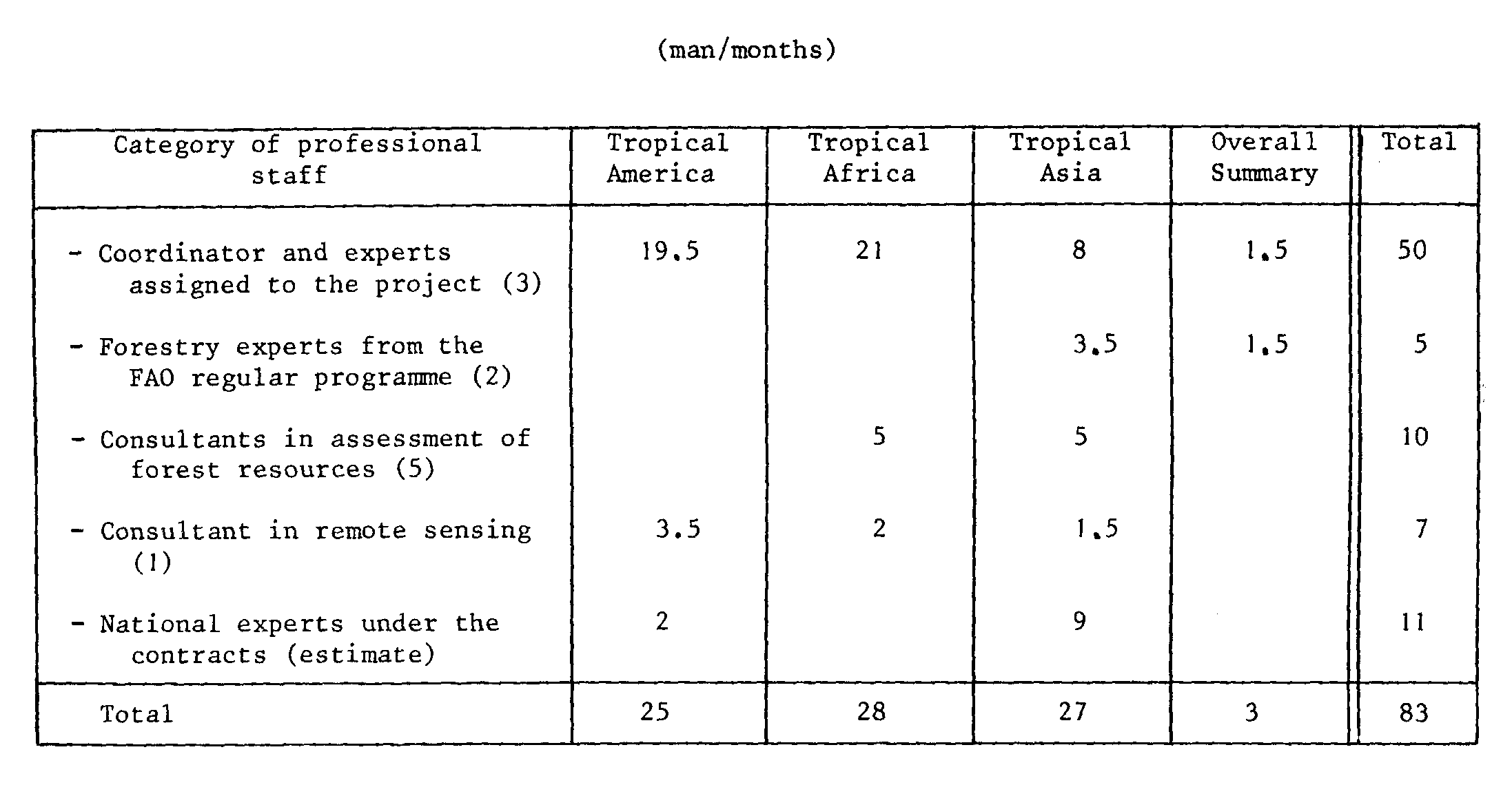
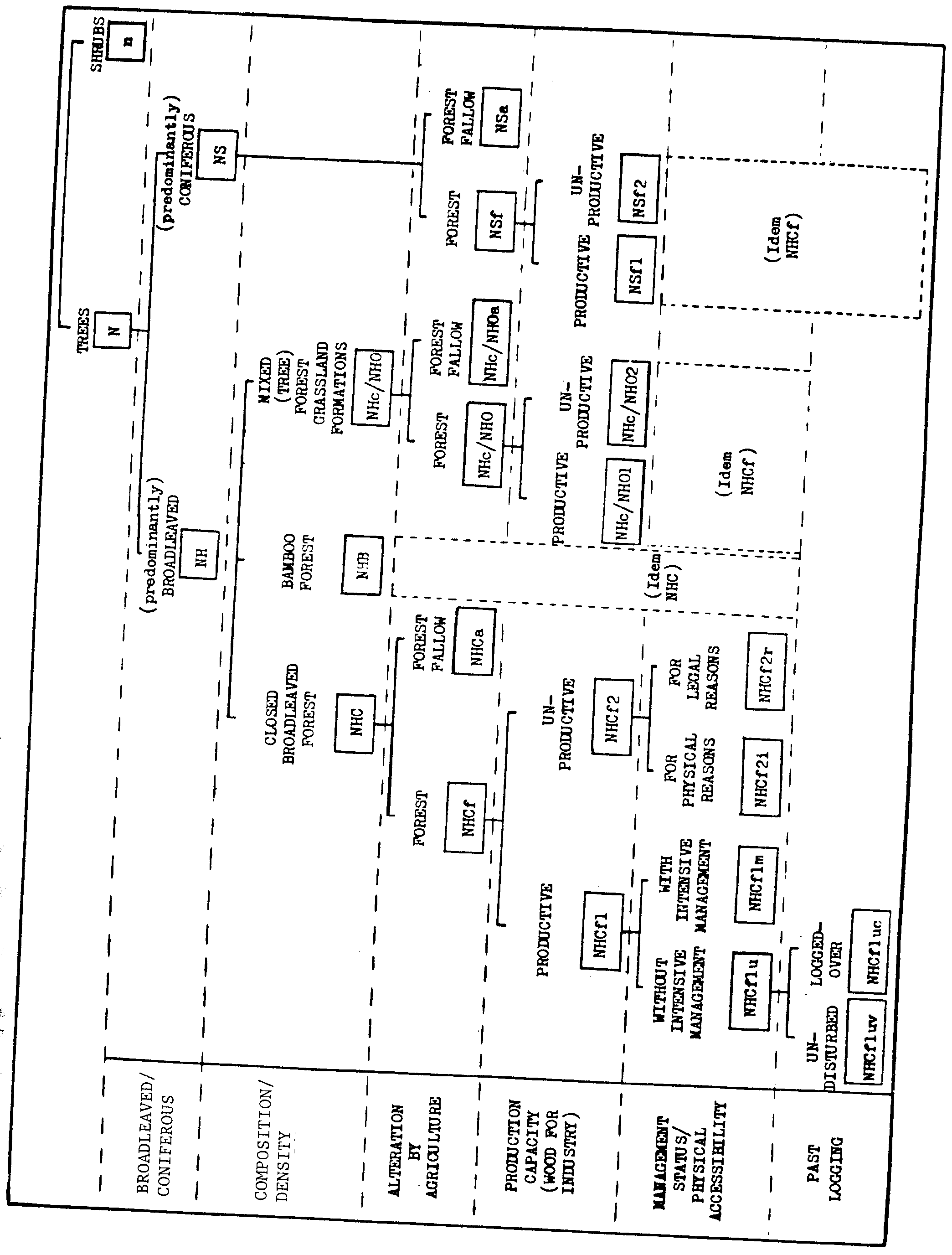
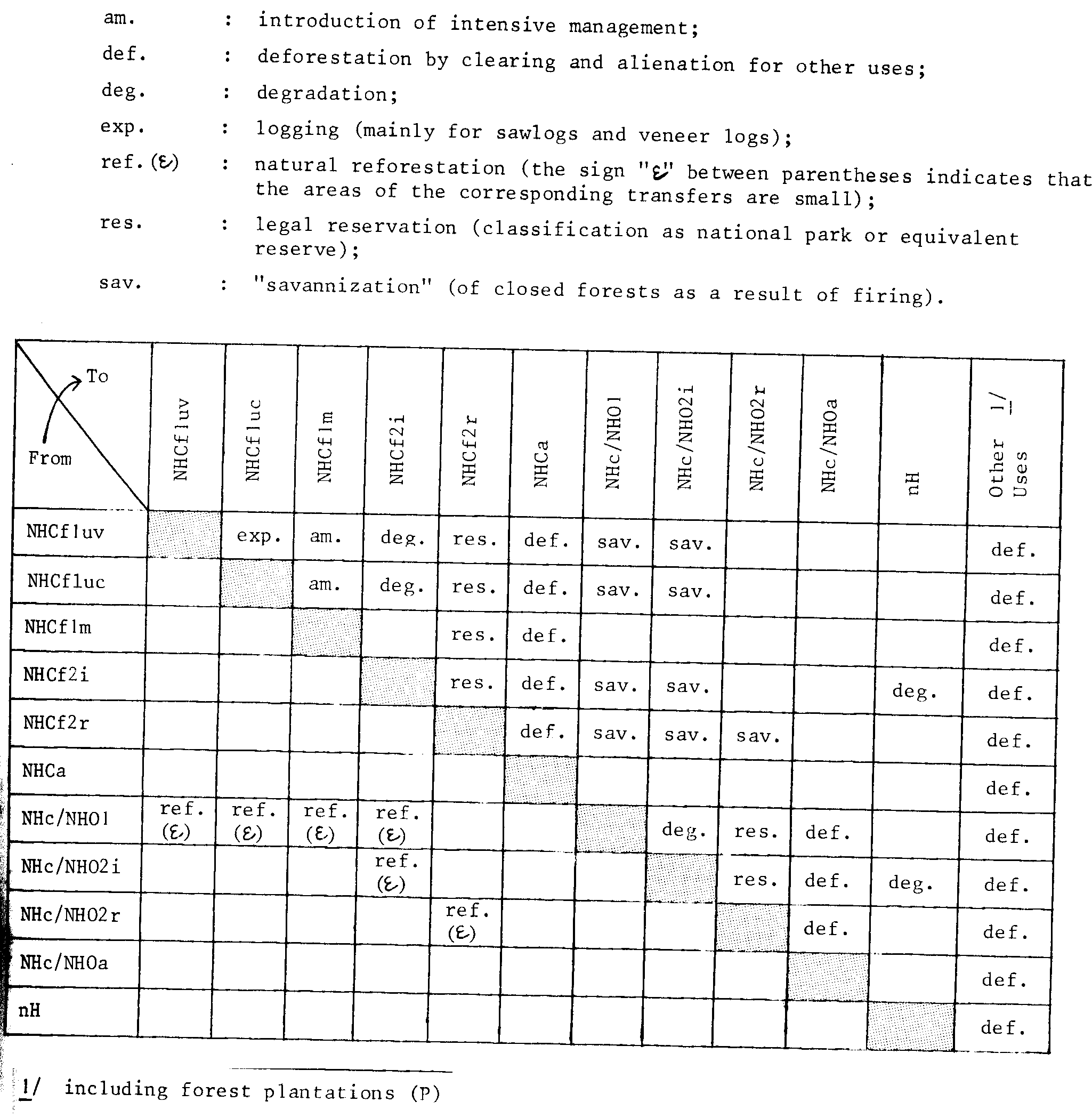
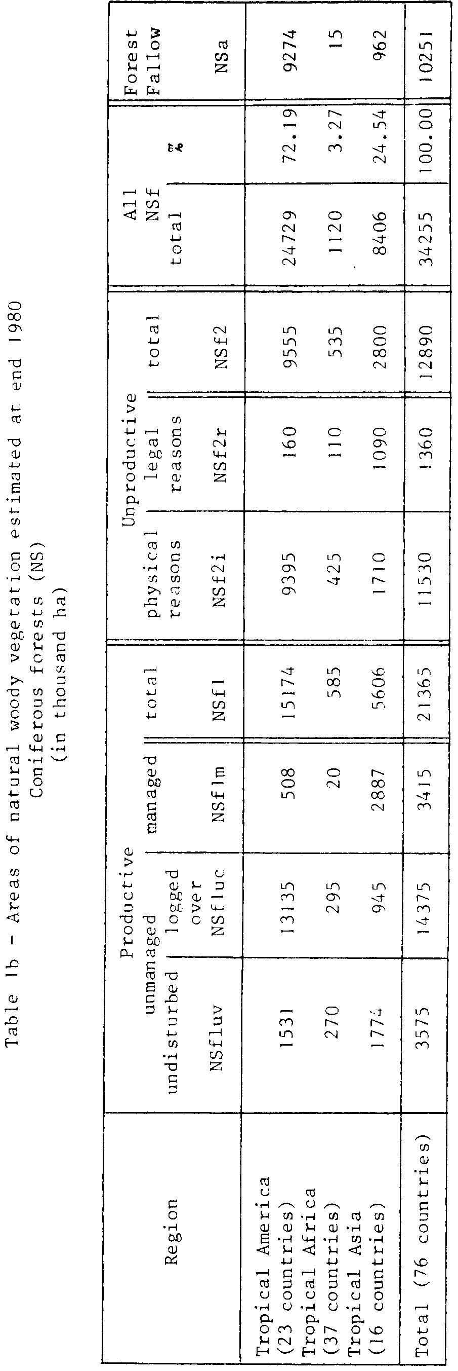
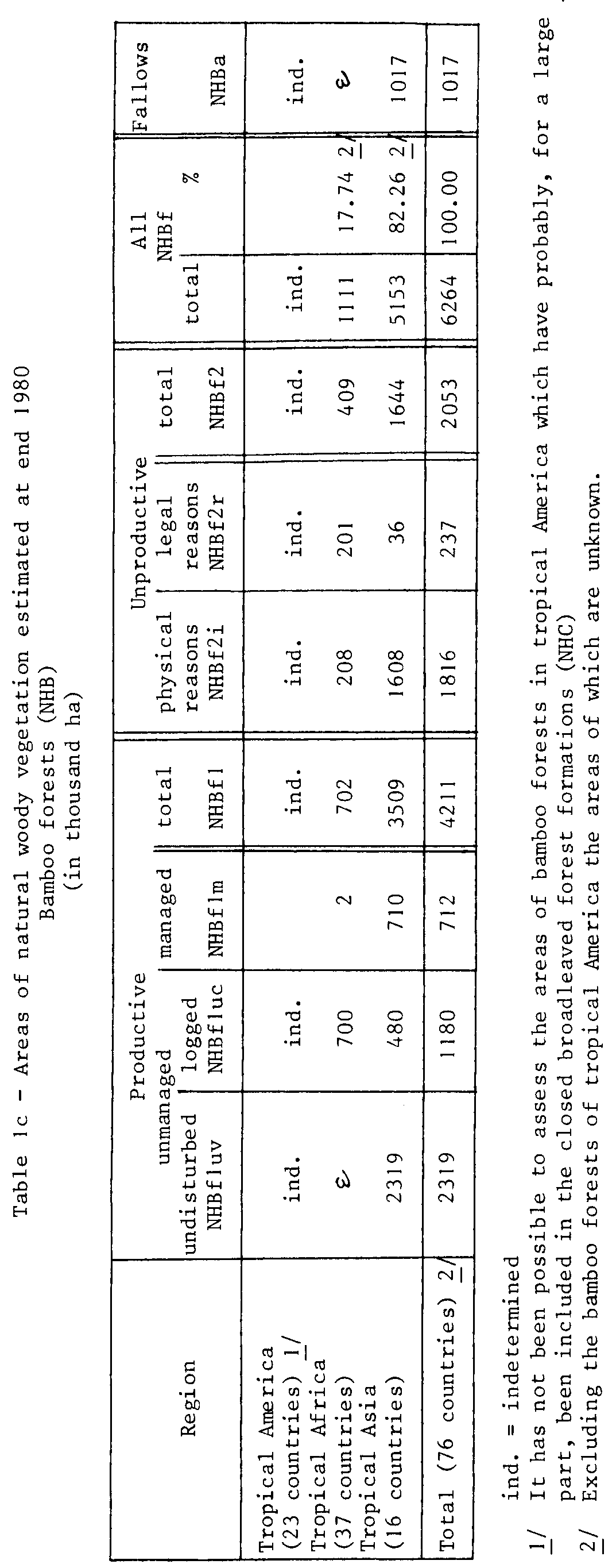
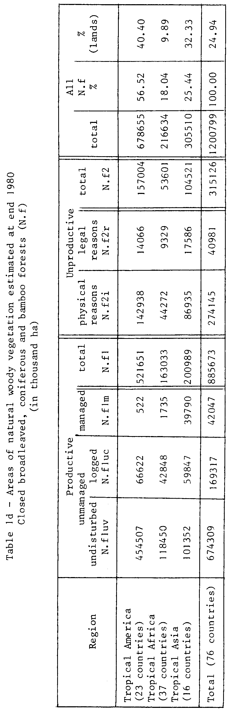
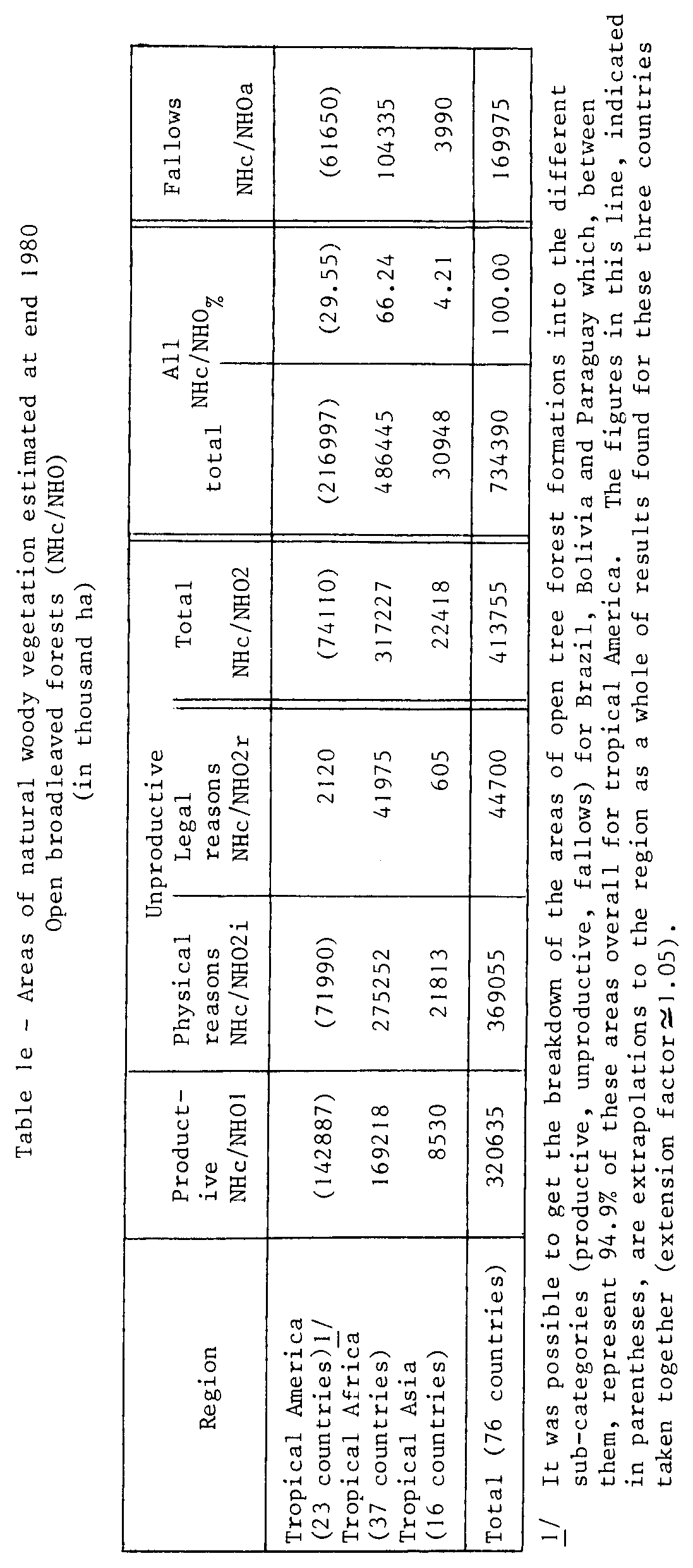
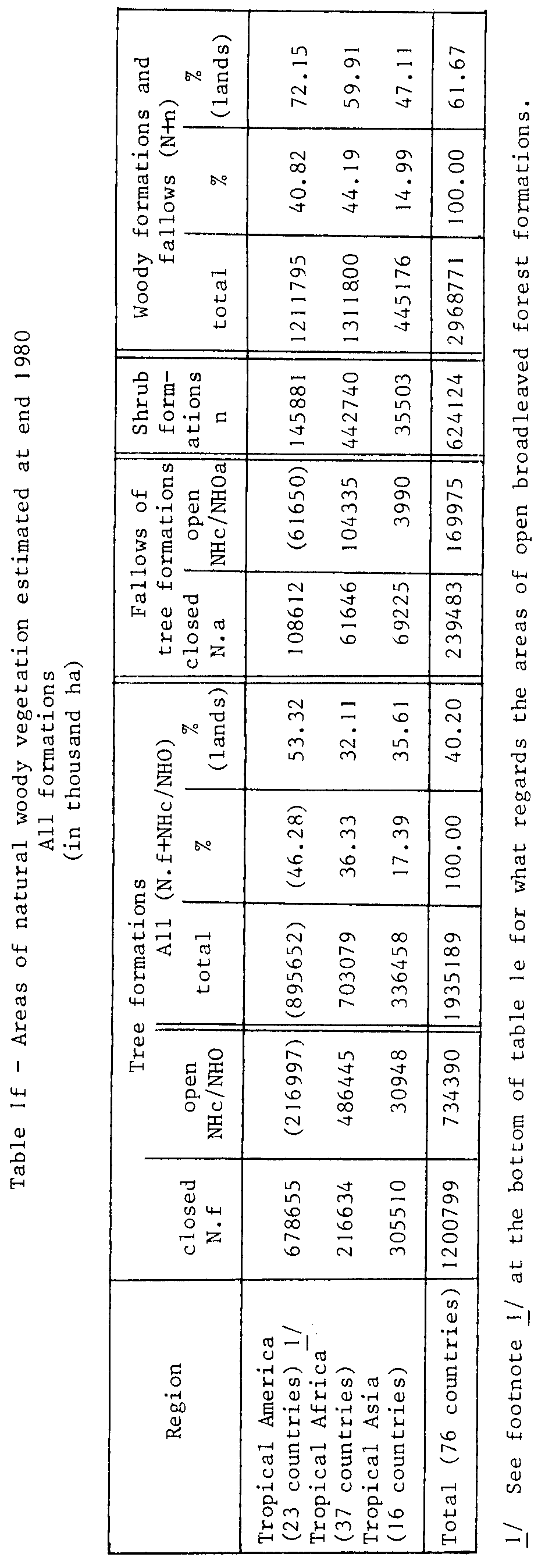
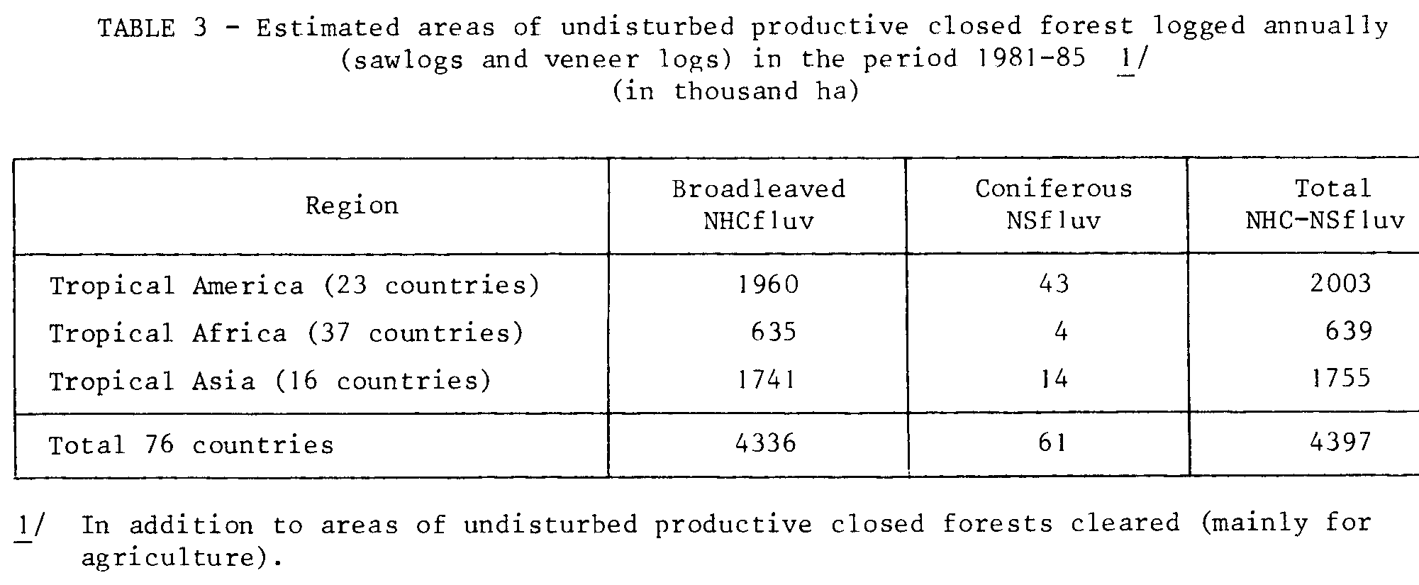
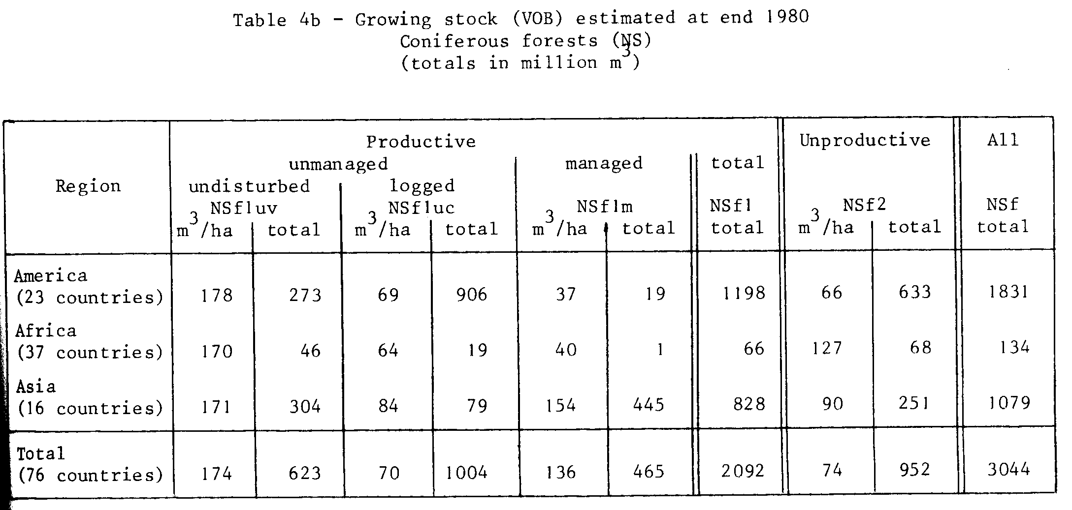
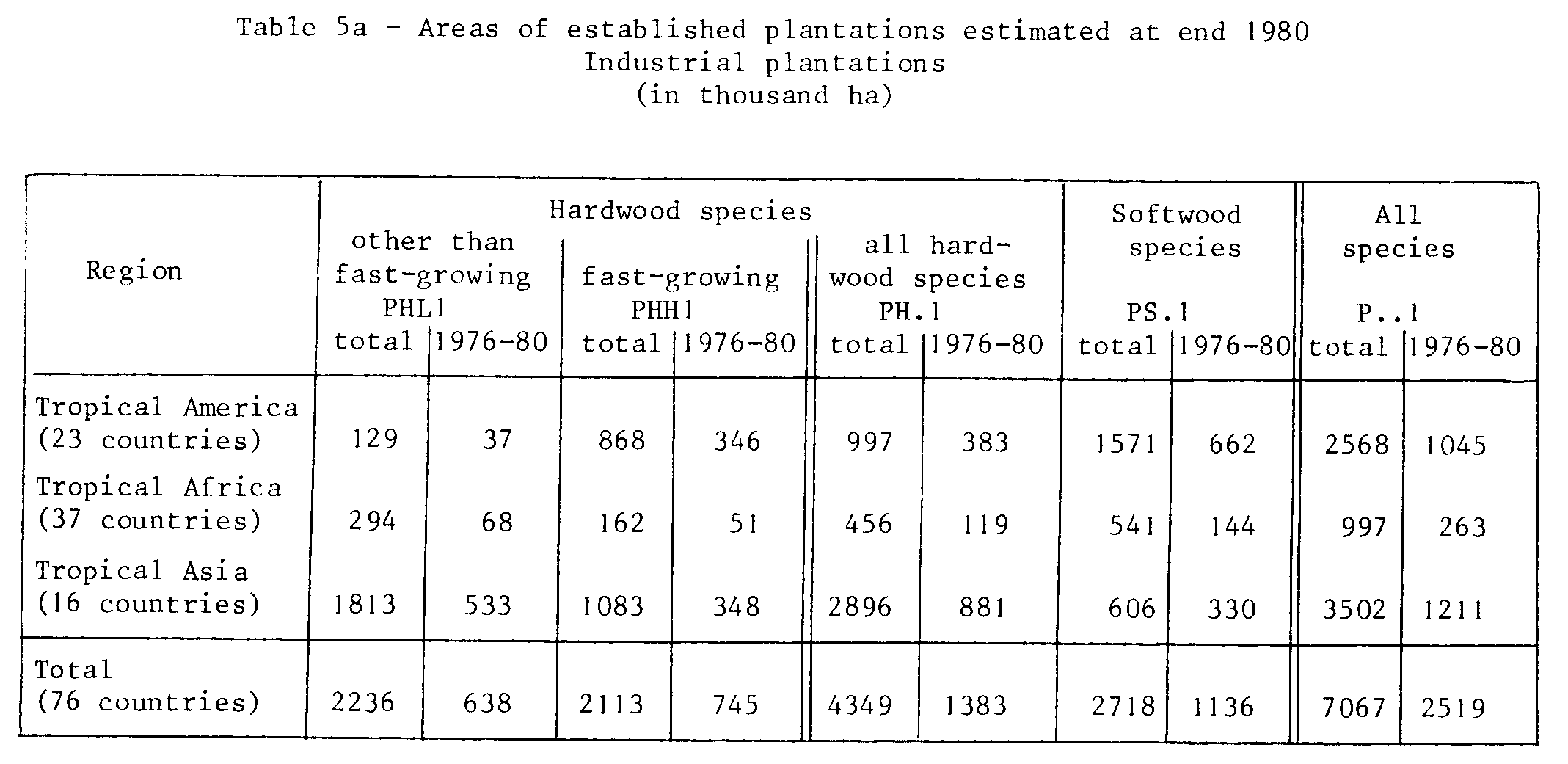
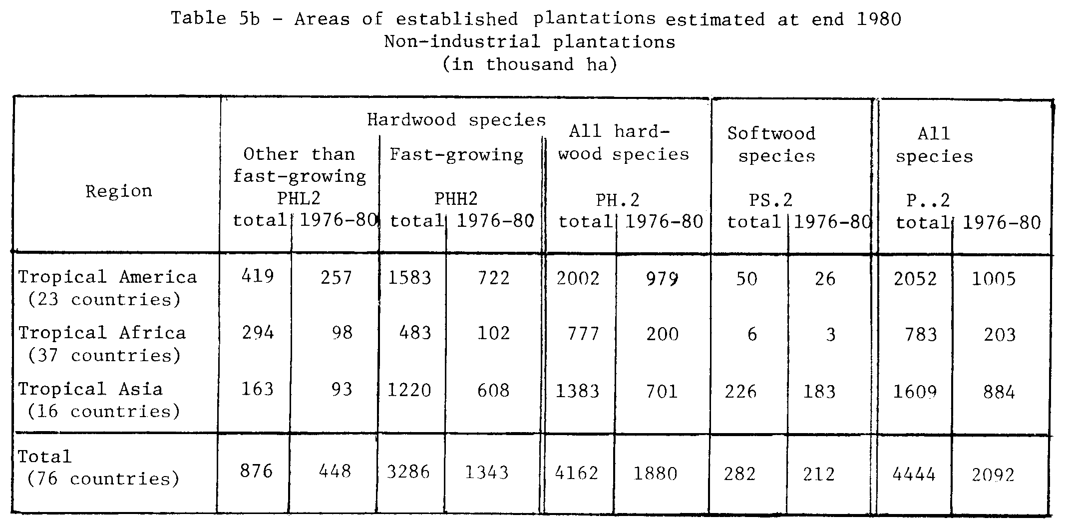
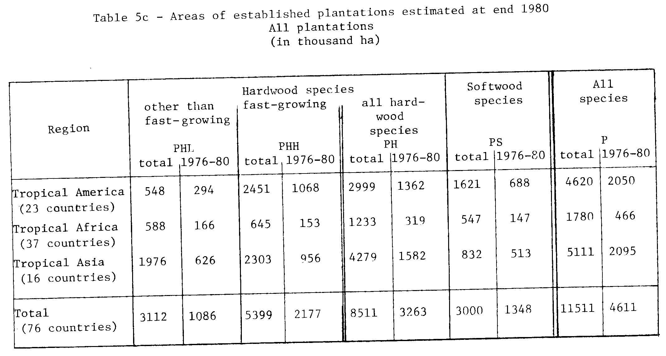
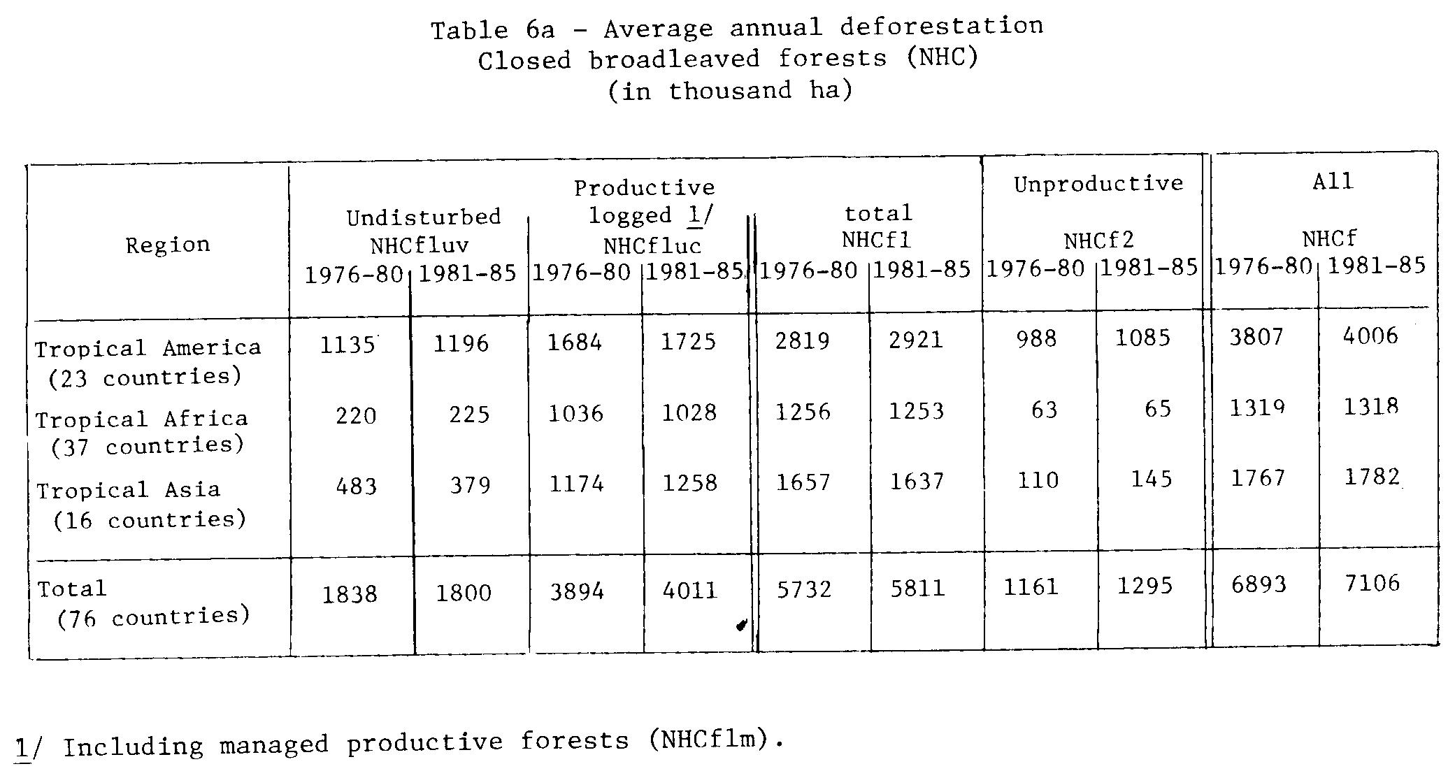
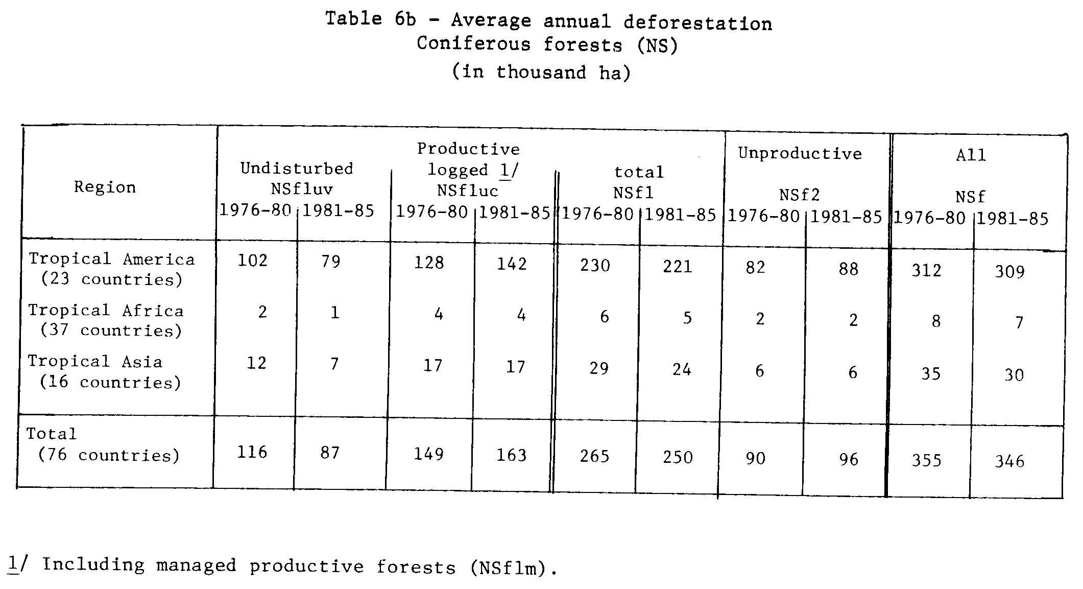
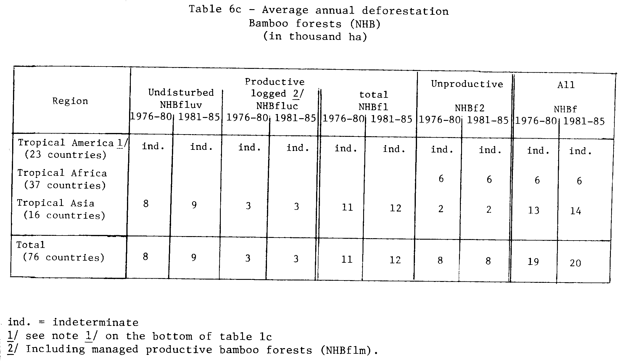
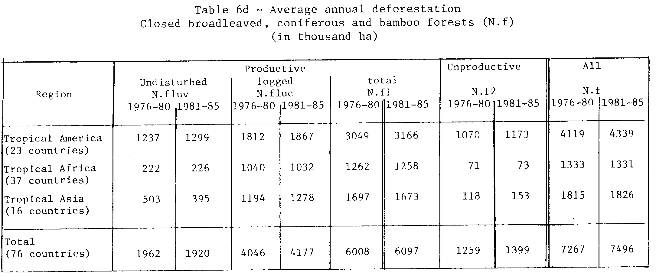
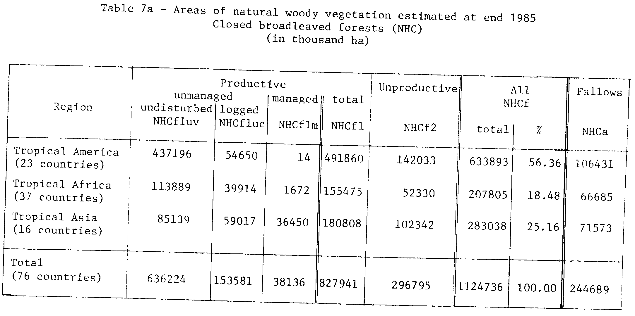
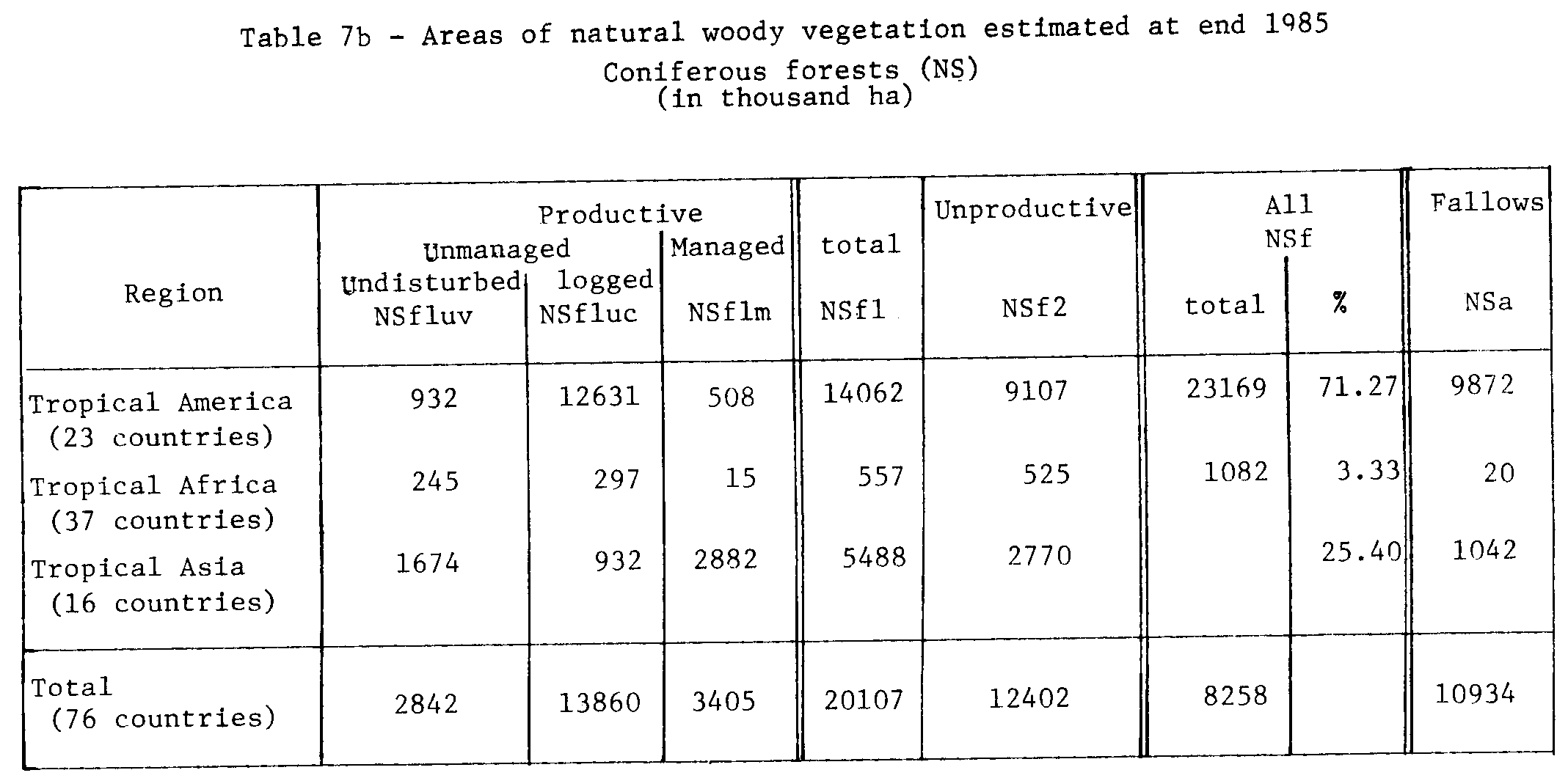
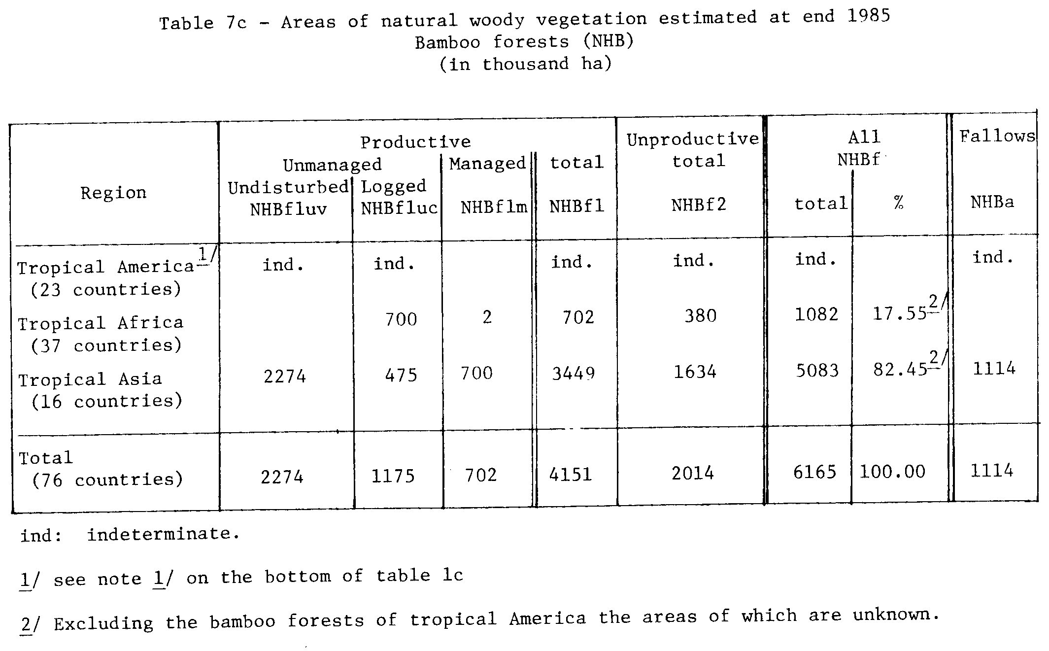
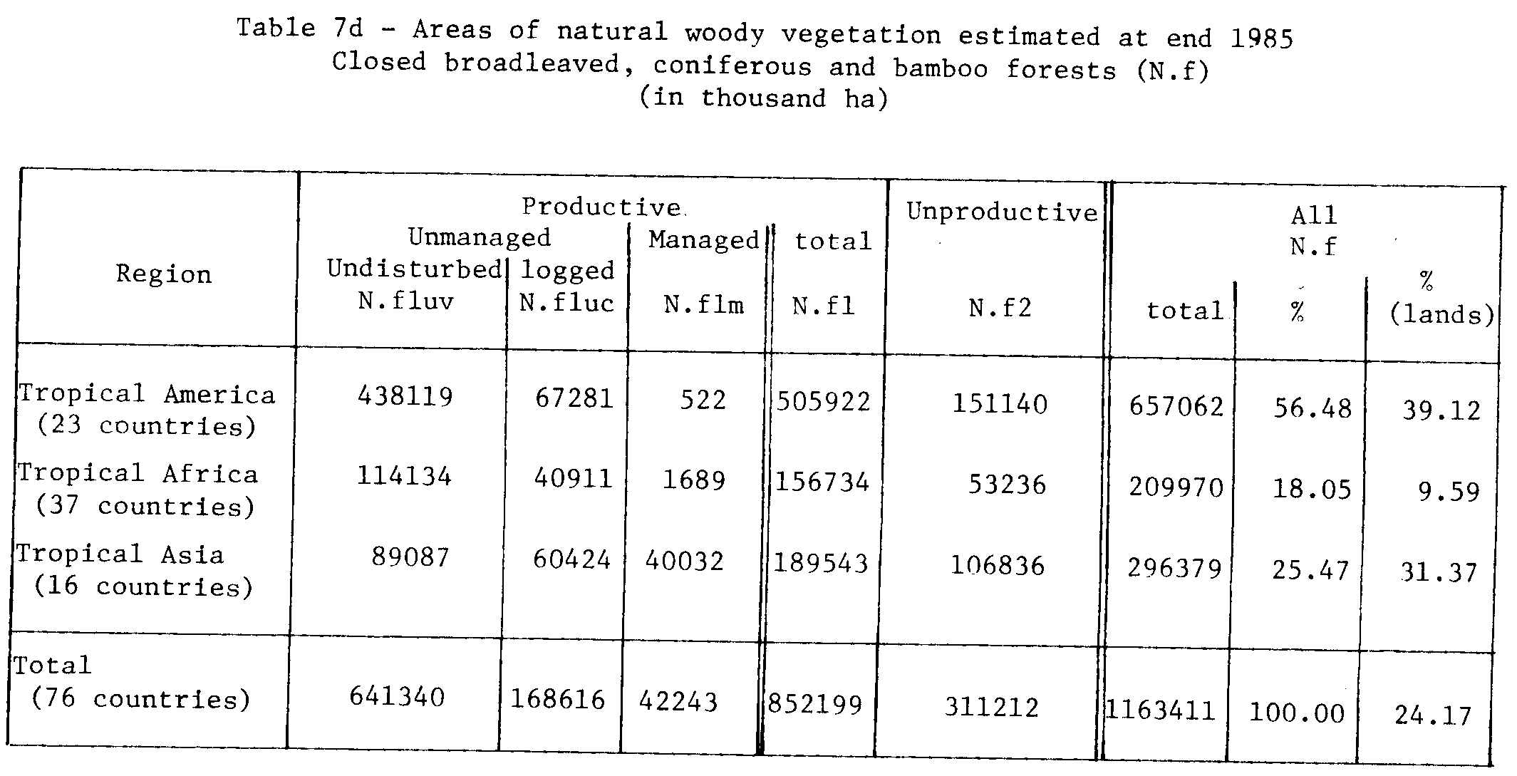
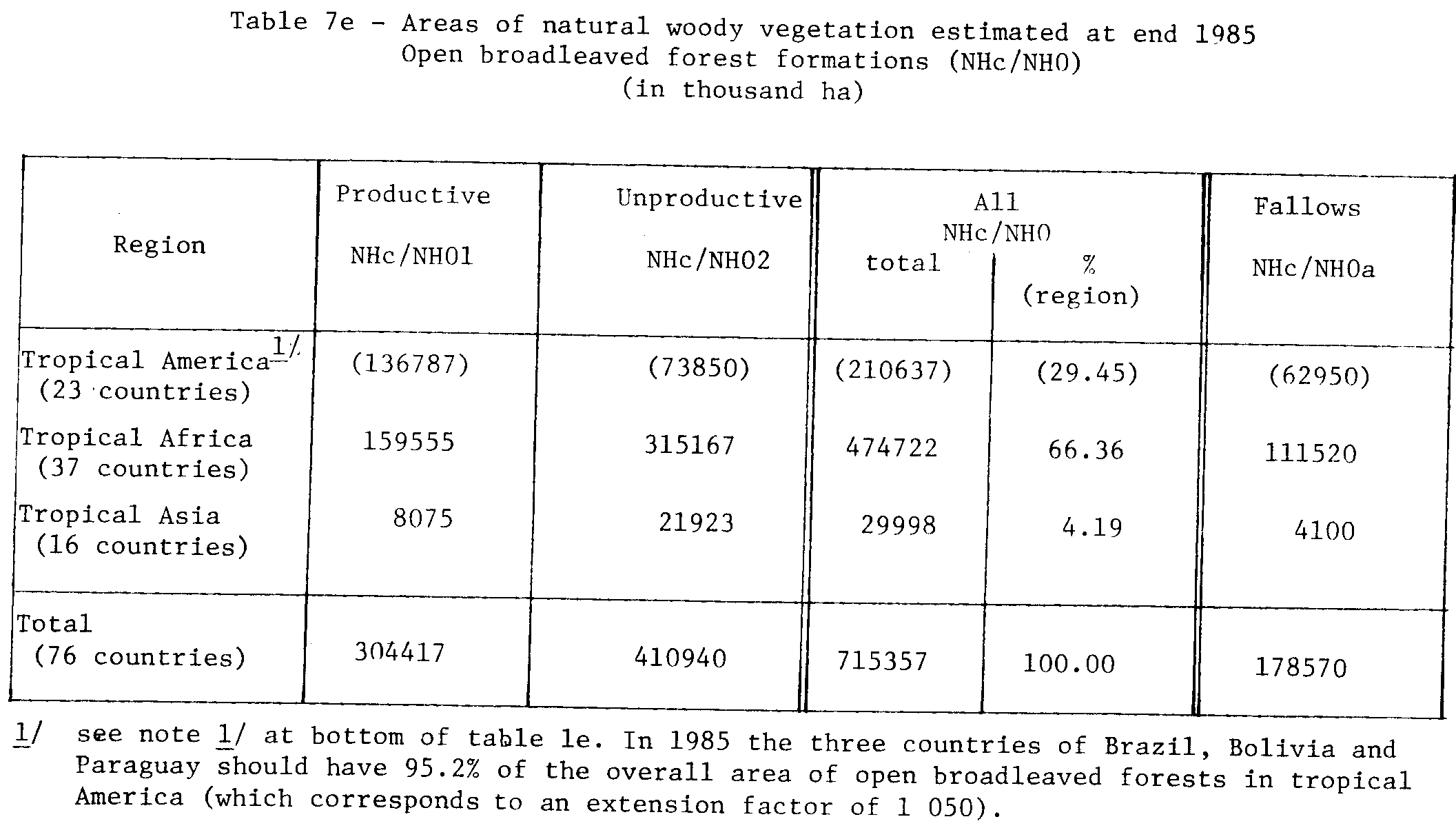
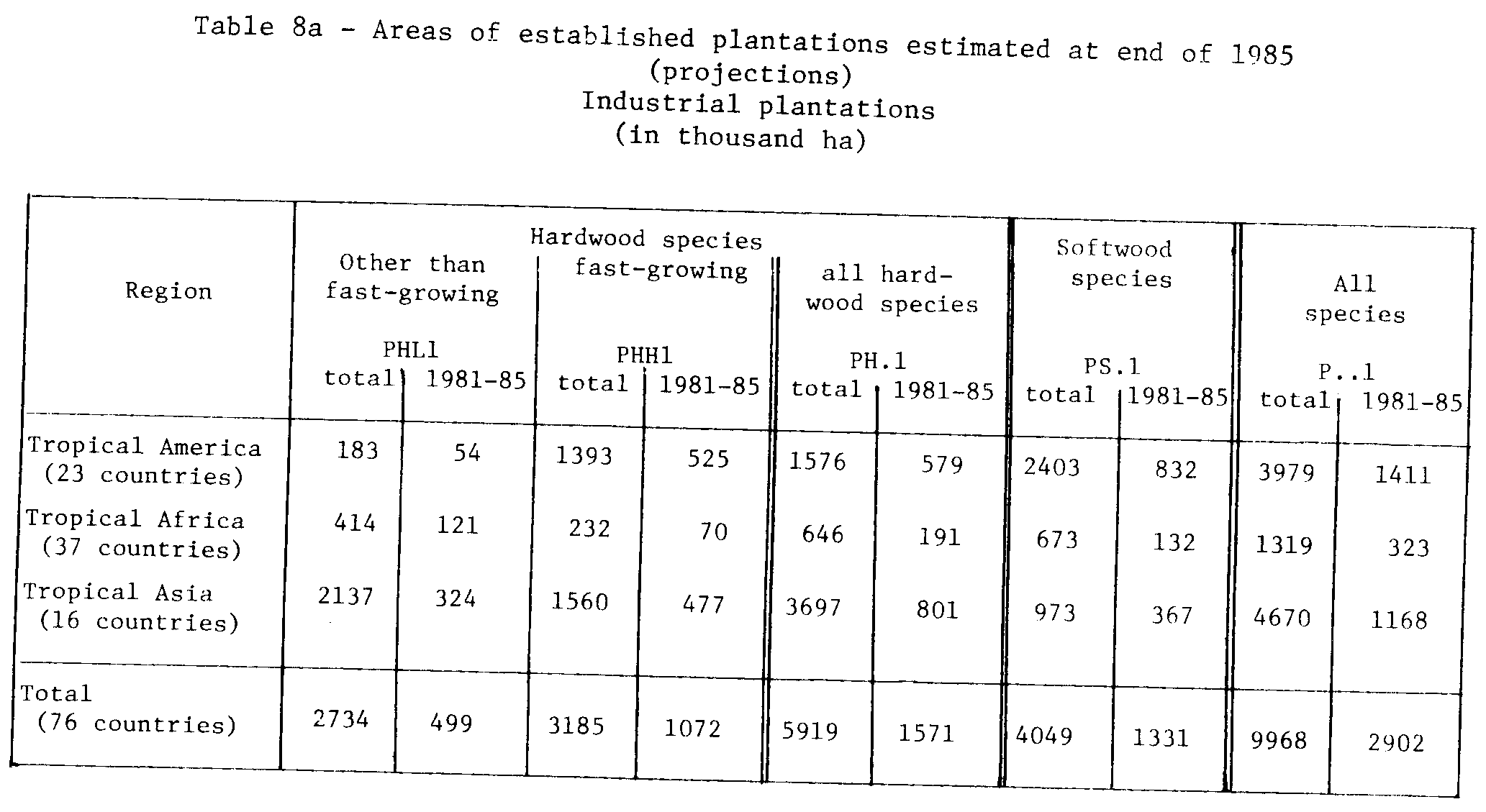
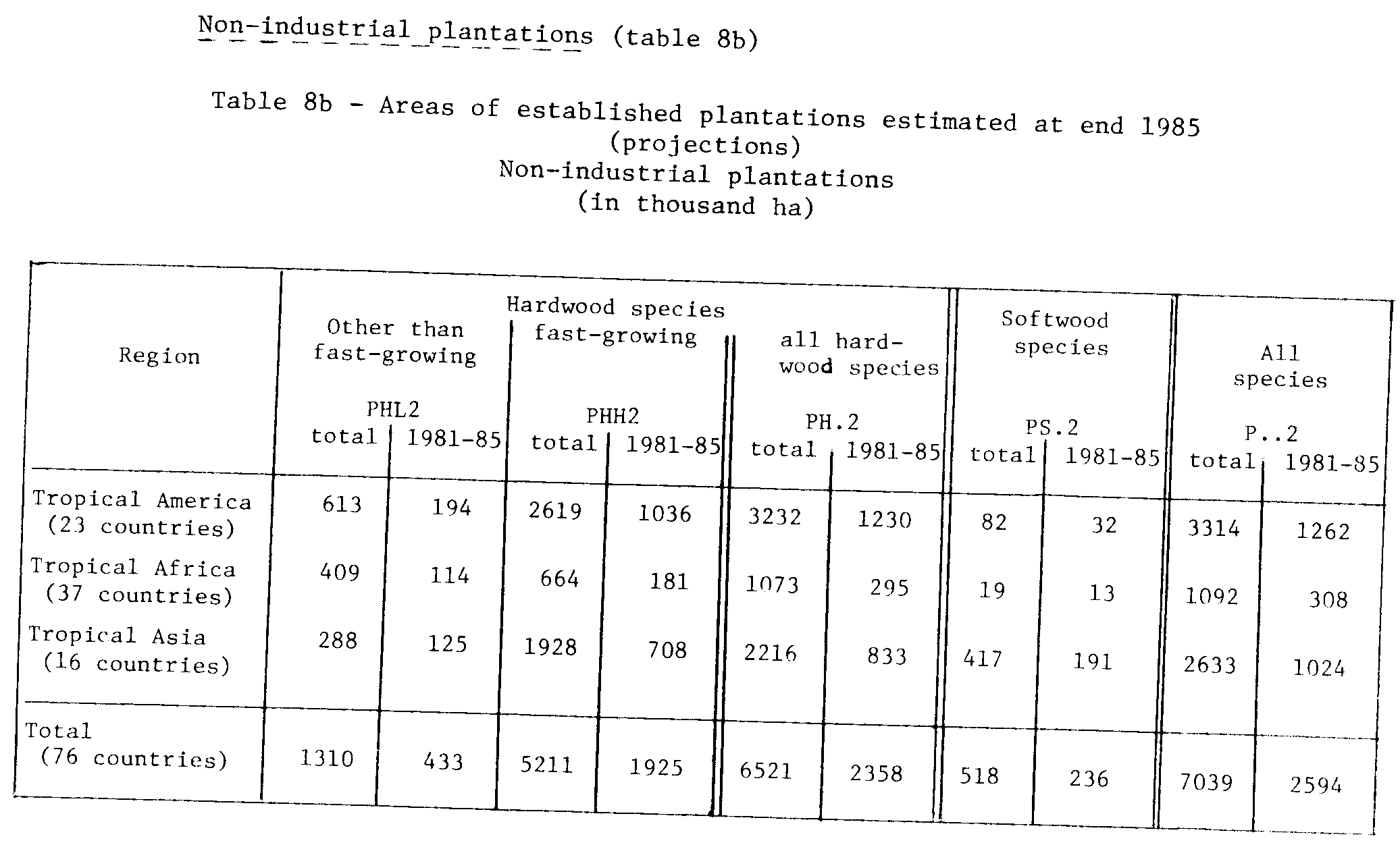
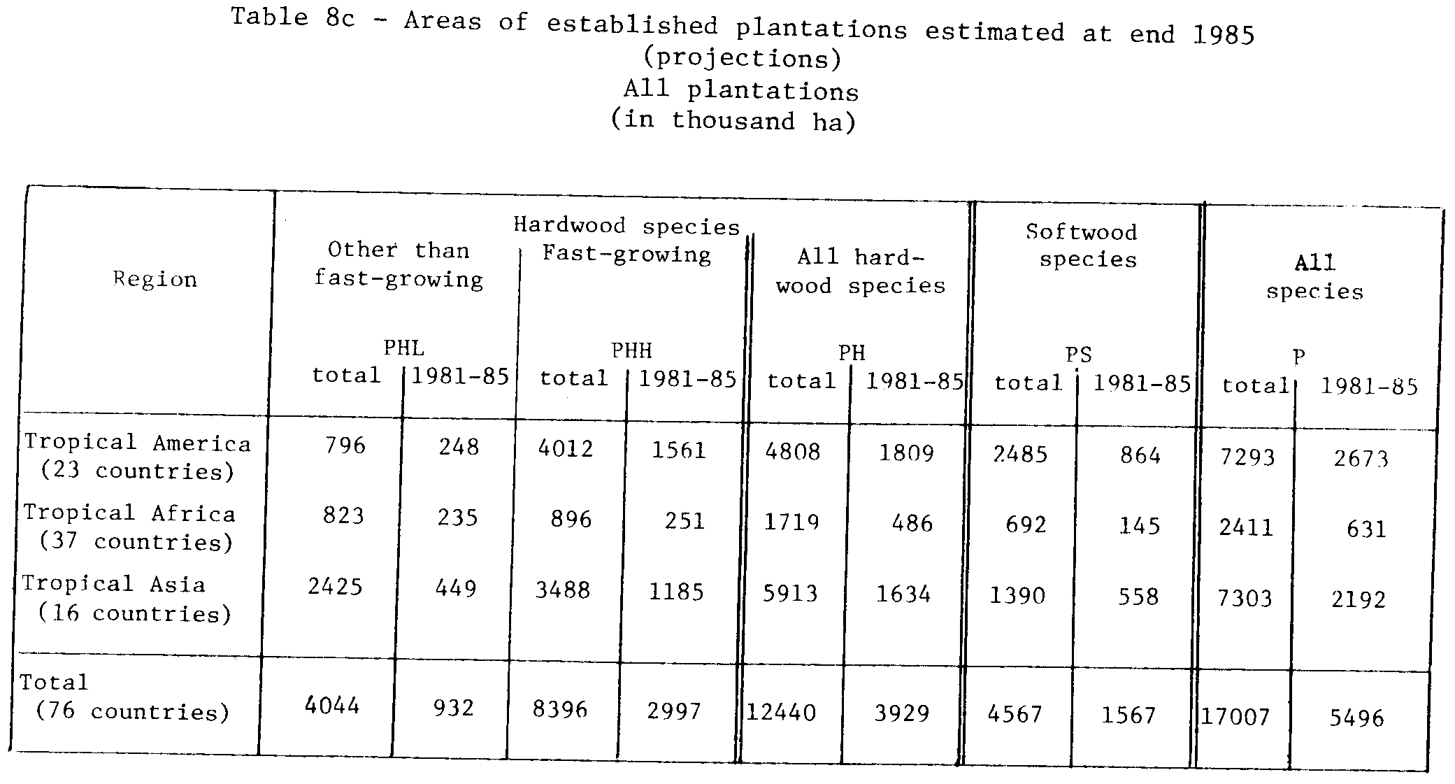
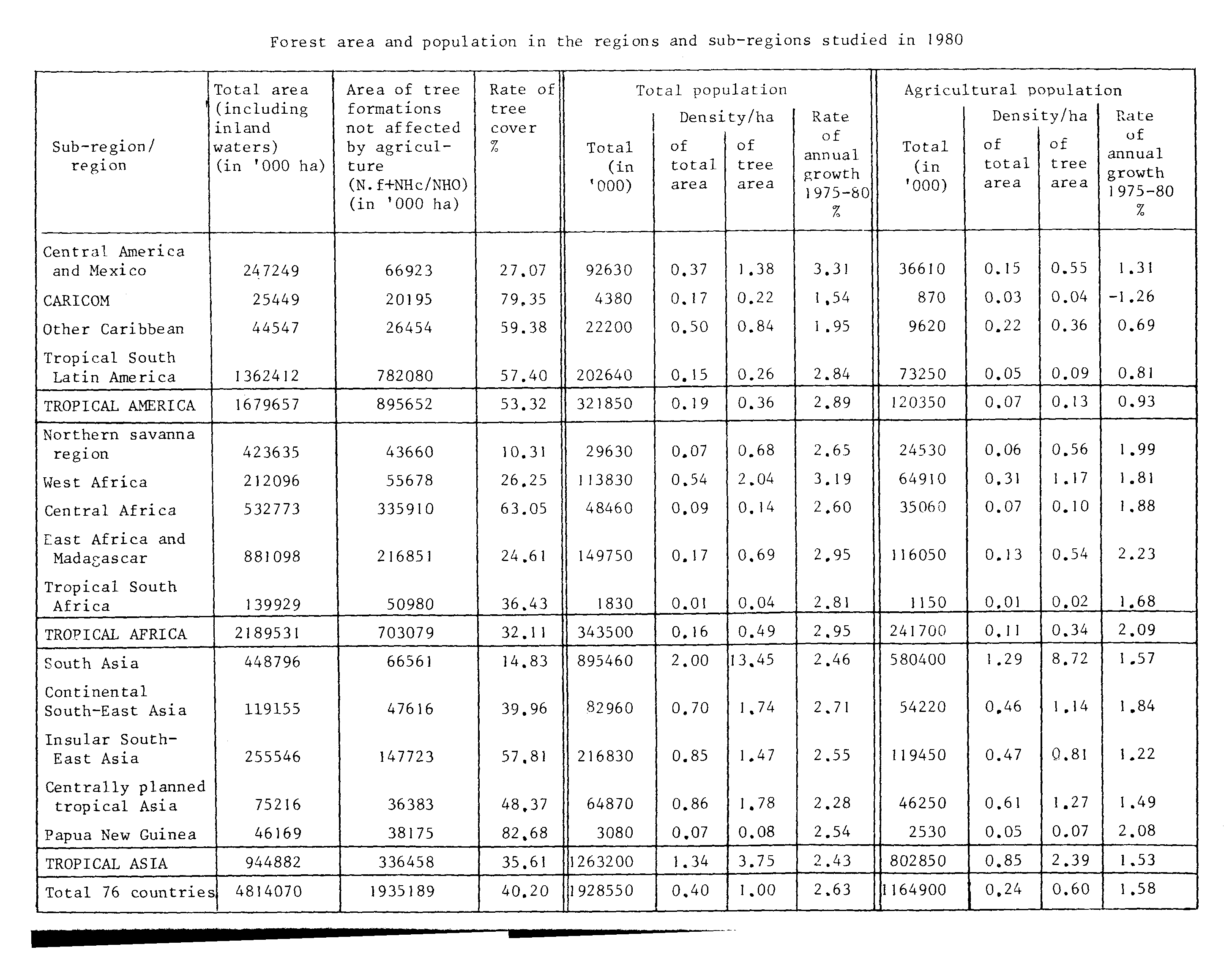
![[a]](tabpg36.gif)
![[b]](tabpg37.gif)
![[a]](tabpg38.gif)
![[b]](tabpg39.gif)
![[c]](tabpg40.gif)
![[d]](tabpg41.gif)
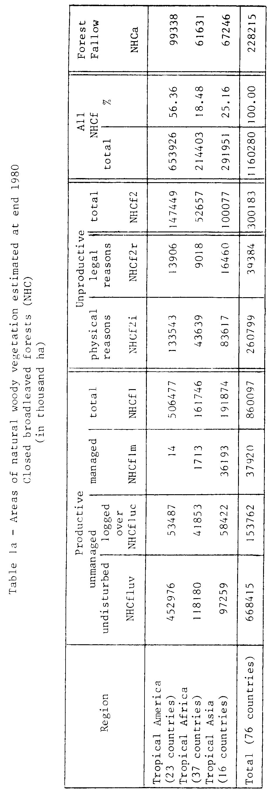
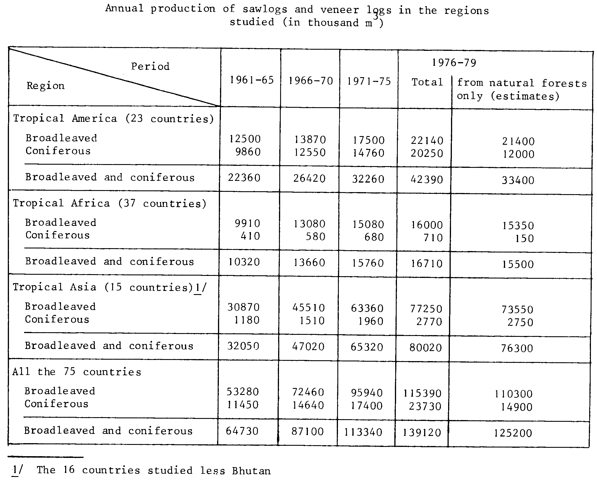
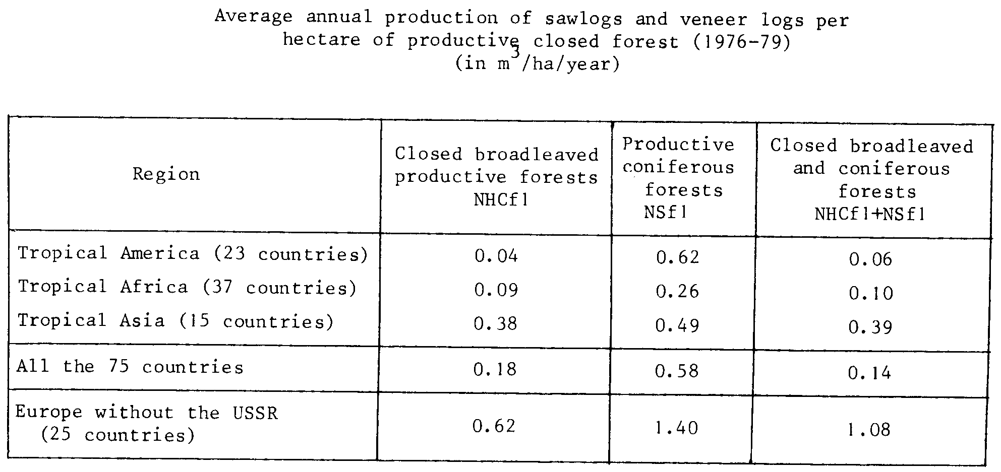
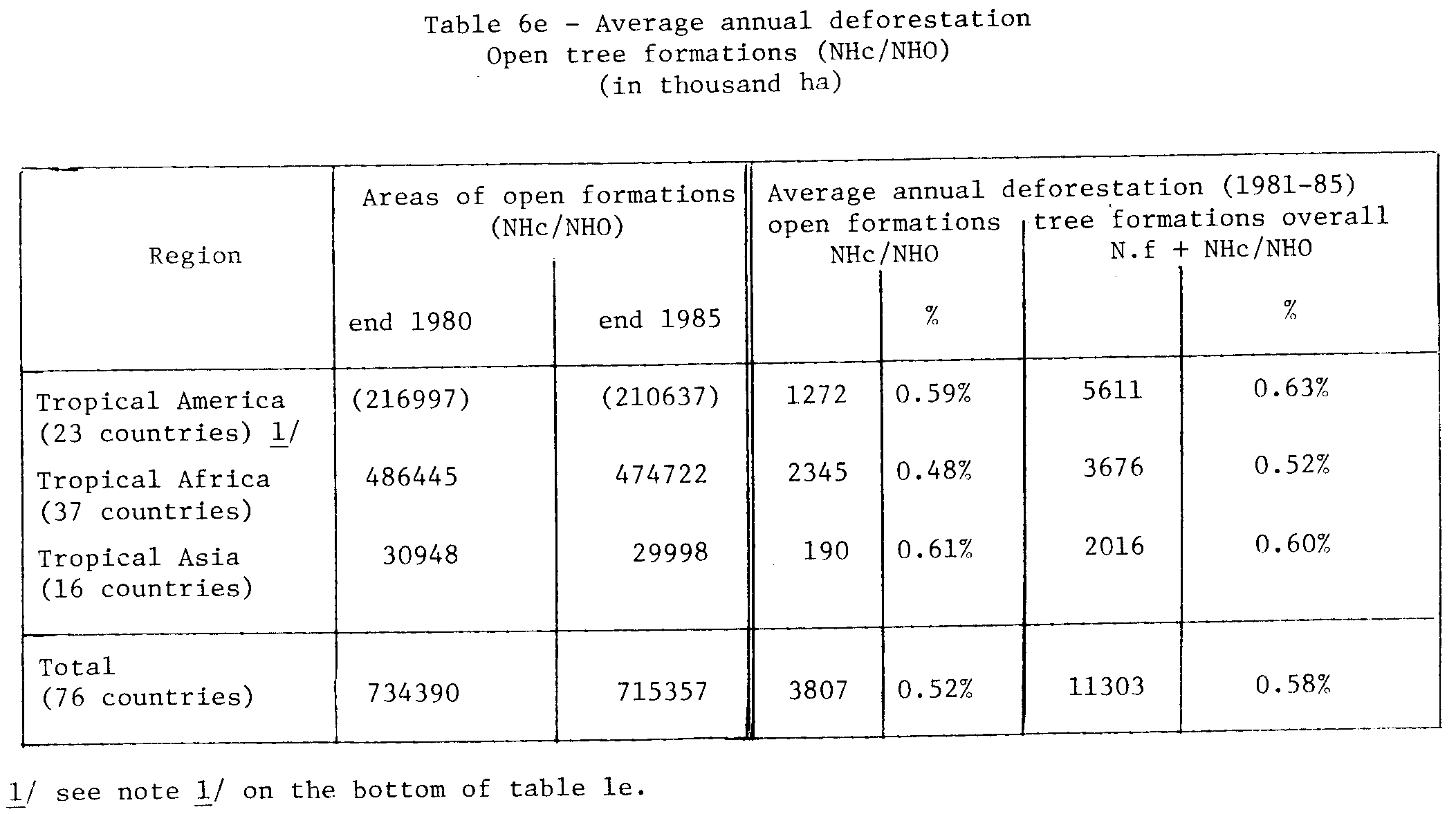
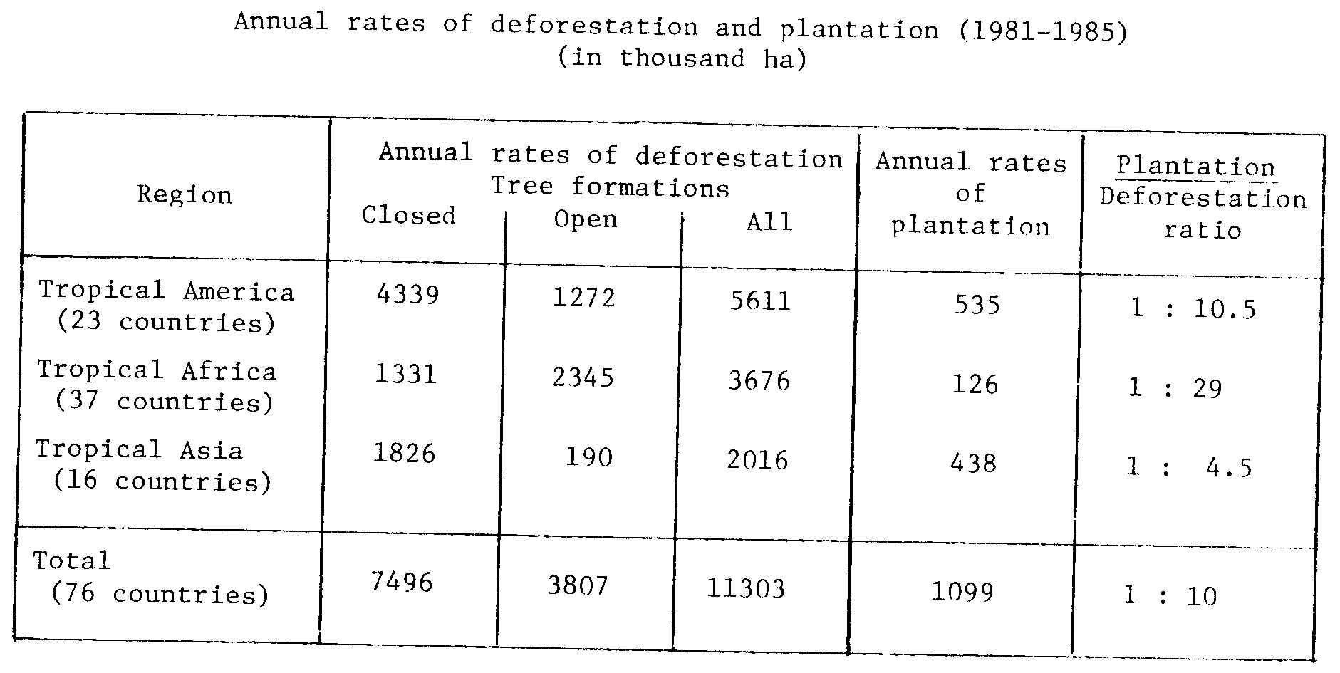
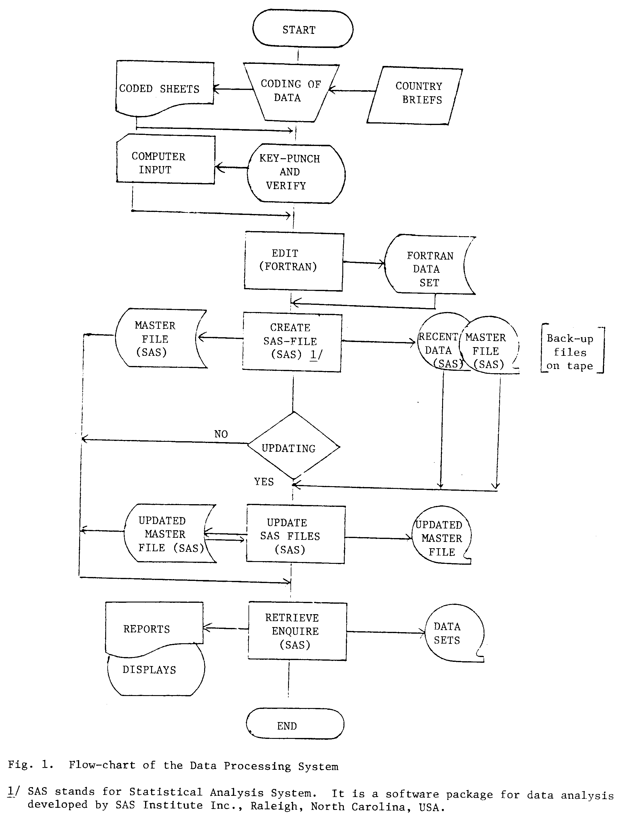