 Reproduced, with permission, from:
Skole, D., and C. Tucker. 1993. Tropical deforestation and habitat fragmentation in the Amazon: Satellite data from 1978 to 1988. Science 260: 1905-09.
Reproduced, with permission, from:
Skole, D., and C. Tucker. 1993. Tropical deforestation and habitat fragmentation in the Amazon: Satellite data from 1978 to 1988. Science 260: 1905-09.
David Skole and Compton Tucker
Landsat satellite imagery covering the entire forested portion of the Brazilian Amazon Basin was used to measure, for 1978 and 1988, deforestation, fragmented forest, defined as areas less then 100 square kilometers surrounded by deforestation, and edge effects of 1 kilometer into forest from adjacent areas of deforestation. Tropical deforestation increased from 78,000 square kilometers in 1978 to 230,000 square kilometers in 1988 while tropical forest habitat, severely affected with respect to biological diversity, increased from 208,000 to 588,000 square kilometers. Although this rate of deforestation is lower than previous estimates, the effect on biological diversity is greater.
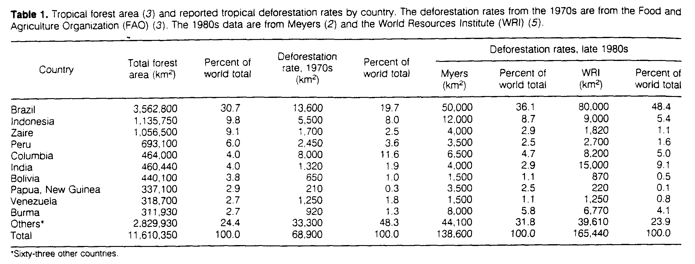
Deforestation has been occurring in temperate and tropical regions throughout history (1). In recent years, much attention has focused on tropical forests, where as much as 50% of the original extent may have been lost to deforestation in the last two decades, primarily as a result of agricultural expansion (2). Global estimates of tropical deforestation range from 69,000 km2 year-1 in 1980 (3) to 100,000 to 165,000 km2 year-1 in the late 1980s; 50 to 70% of the more recent estimates have been attributed to deforestation in the Brailian Amazon, the largest continuous region of tropical forest in the world (2, 4, 5).
The area and rate of deforestation in Amazonia are not well known, nor are there ,quantitative measurements of the effect of deforestation on habitat degradation. We used 1:500,000 scale photographic imagery from Landsat Thematic Mapper data and a geographic information system (GIS) to create a computerized map of deforestation and evaluate its influence on forest fragmentation and habitat degradation. Areas of deforestation were digitized into the GIS and the forest fragments and edge effects that result from the spatial pattern of forest conversion were determined.
Tropical deforestation is a major component of the carbon cycle and has profound implications for biological diversity. Deforestation increases atmospheric CO2 and other trace gases, possibly affecting climate (6, 7). Conversion of forests to cropland and pasture results in a net flux of carbon to the atmosphere because the concentration of carbon in forests is higher than that in the agricultural areas that replace them. The paucity of data on tropical deforestation limits our understanding of the carbon cycle and possible climate change (8). Furthermore, while occupying less than 7% of the terrestrial surface, tropical forests are the home to half or more of all plant and animal species (9). The primary adverse effect of tropical deforestation is massive extinction of species including, for the first time, large numbers of vascular plant species (10).
Deforestation affects biological diversity in three ways: destruction of habitat, isolation of fragments of formerly contiguous habitat, and edge effects within a boundary zone between forest and deforested areas. This boundary zone extends some distance into the remaining forest. In this zone there are greater exposure to winds; dramatic micrometeorological differences over short distances; easier access for livestock, other nonforest animals, and hunters; and a range of other biological and physical effects. The result is a net loss of plant and animal species in the edge areas (11).
There is a wide range in current estimates of the area and rate of deforestation in Amazonia. Scientists at the Instituto Nacional de Pesquisas Espaciais (12-15) estimated a total deforested area of 280,000 km2 as of 1988 and an average annual rate of 21,000 km2 year-l from 1978 to 1988. Other studies (2, 4, 5) have reported rates that range from 50,000 to 80.000 km year-l (Table 1). Additional deforestation estimates have been made for geographically limited study areas in the southern Amazon Basin of Brazil with Landsat and meteorological satellite data (16-20).
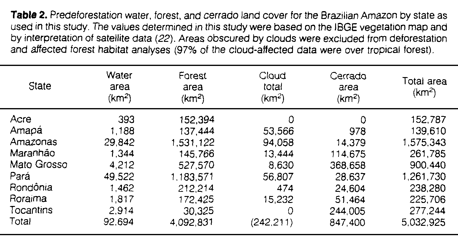
The Amazon Basin of Brazil has been defined by law to include the states of Acre, Amapa, Amazonas, Para, Rondonia, and Roraima plus part of Mato Grosso. Maranhao, and Tocantins and is referred to as the Legal Amazon (21). It covers an area of ~5,000,000 km2, of which ~4,090,000 km2 is forested, ~850,000 km2 is cerrado or tropical savanna, and ~90,000 km2 is water (Table 2). Confusion has arisen among researchers regarding the stratification of the Brazilian Amazon into forest, cerrado, and water strata. A Food and Agriculture Organization (FAO)-United Nations Environmental Program (UNEP) study (3) found 3,562,800 km2 of forest, whereas Fearnside and co-workers claim there is 4,195,660 km2 of forest, 793,279 km2 of cerrado (17), and 4,906,784 km2 total (13). Meanwhile, an IBGE study (22) found 20,972 km2 of water, 3,793,664 km2 of forest, and 1,149,943 km2 of cerrado for a total of 4,964,920 km2. These differences prevent comparison of different deforestation studies.
The use of satellite data and the GIS make it possible to explicitly stratify Amazonia on the basis of cover types (22), thereby providing a means of comparison with other studies. This approach is also necessary for spatial analysis of habitat fragmentation and edge effects of deforestation. Finally, GIS provides a data management tool with which we could manage large amounts of spatial data and precisely merge and geocode information from the more than 200 satellite images used in this study.
The large area of the Brazilian Amazon necessitates a straightforward and accurate method of measurement. Landsat Thematic Mapper photo products are inexpensive and of sufficient spatial and spectral resolution for the determination of deforestation. Analysis with visual interpretation techniques produces quantitative results similar to digital processing of full-resolution, multispectral data from the Thematic Mapper and SPOT (23).
We acquired 210 black and white photographic images of the entire Brazilian Amazon. They were obtained with channel five of the Landsat Thematic Mapper (1.5; to 1.75 um) at 1:500,000 scale and were primarily from 1988 (24). We digitized the deforested areas with visual deforestation interpretation and standard vector GIS techniques (Fig. 1). The digitized scenes were projected into equal-area geographic coordinates (latitude, longitude), edge matched, and merged in the computer to form a single, seamless dataset for the entire Brazilian Amazon.
Spatial analysis of the geometry of deforestation is critical to the estimation of forest fragmentation and the edge effect. If 100 km2 of tropical deforestation occurs as a 10 km by 10 km square and we assume that the edge effect is 1 km, the total area affected is ~143 km2. In contrast, if the 100 km2 of deforestation is distributed as ten strips, each 10 km by 1 km, the affected area is ~350 km2.
We extracted forest fragments <100 km2 that were isolated by deforestation and computed edge effects for a zone of 1 km along the boundaries. All areas of closed-canopy tropical forest deforested by 1988 were delineated, including areas of secondary growth on abandoned fields and pasture where visible (Fig. 1). Areas of long-term forest degradation along river margins in central Amazonia were also included, as; were scattered small clearings associated with rubber tappers, mining operations, airfields, and other small disturbances. All visible roads, power line right of ways, pipelines, and similar human-made features were also digitized into the GIS and treated as deforestation. We used 50 digital Landsat Multispectral Scanner (MSS) scenes from 1986 and 15 digital Thematic Mapper images from 1988 for detailed examination of Acre, Amazonas, Mato Grosso, Para, and Rondonia.
To determine the extent of deforestation in 1978, we used the GIS to digitize maps of scale 1:500,000 from single-channel Landsat MSS data, produced jointly by the Instituto Brasiliero de Desenvolvimento Florestal (IBDF) and the Instituto de Pesquisas Espaciais (INPE) in the early 1980s (12, 23). These maps did not differentiate between forest and cerrado cleaning. We compiled forest, cerrado, and water data by combining a vegetation map with analysis of Landsat images and meteorological satellite data (25). Our deforestation and affected habitat analyses for 1978 and 1988 were restricted to closed-canopy forest of the Brazilian Amazon.
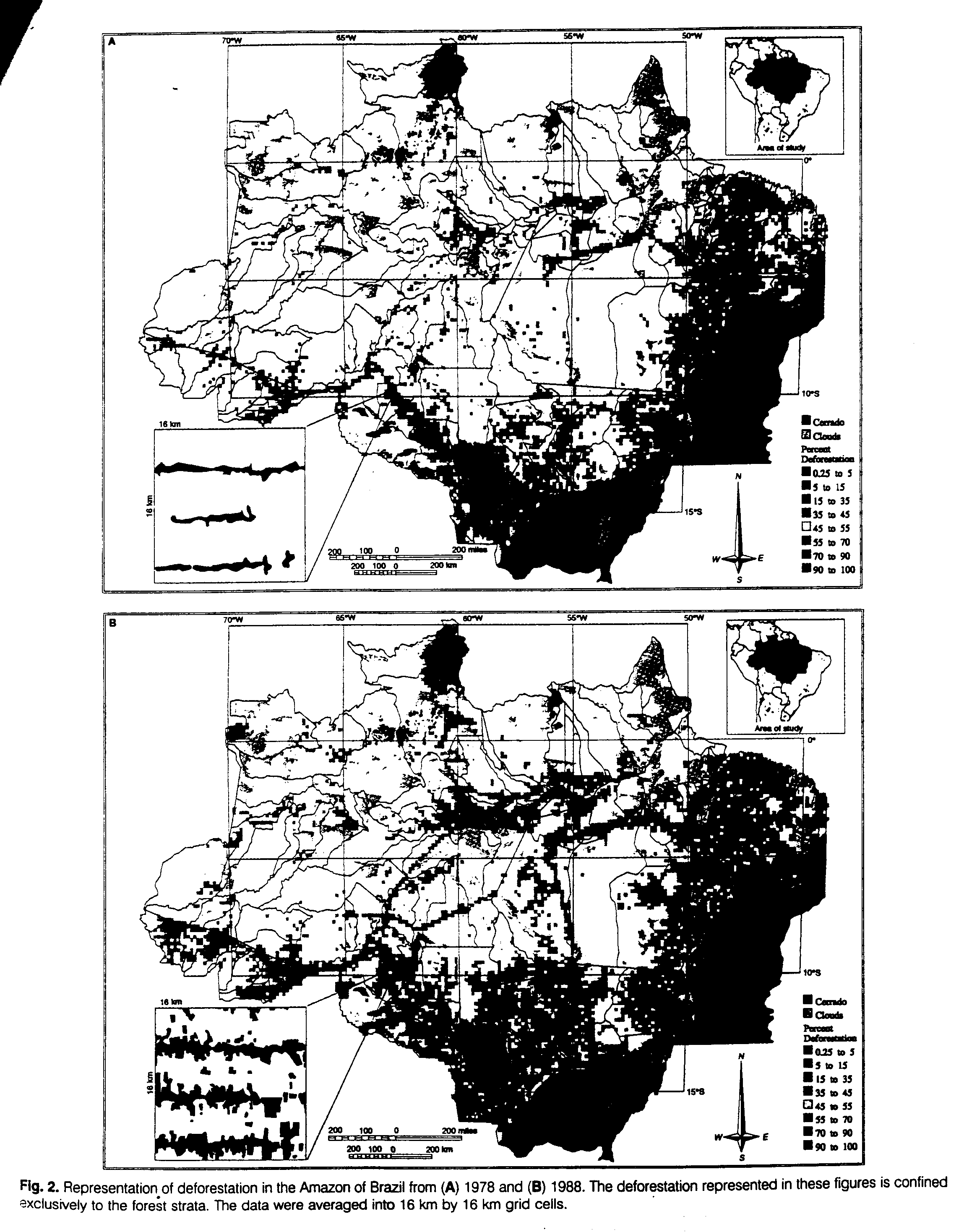
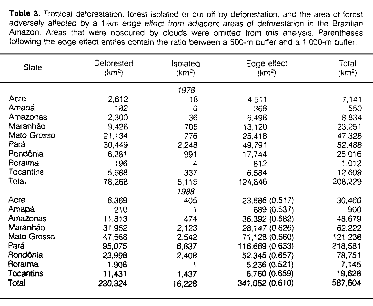
Distribution of deforestation and affected habitat in the Brazilian Amazon for 1978 and 1988 (Figs. 2 and 3) was concentrated in a crescent along the southern and eastern fringe of the Amazon [a spatial pattern similar to the distribution of fires observed from thermal anomalies in data from Landsat's Advanced Very-High Resolution Radiometer (AVHRR) (20)] and along major transportation corridors in the interior of the Amazon. Deforestation increased between 1978 and 1988 (78,000 to 230,000 km2), while the total affected habitat increased (208,000 to 588,000 km2) (Table 3). The total area deforested increased by a factor of two to three or more in every state except Amapa; but it is likely that the deforested area in Amapa is higher than our assessment because excessive cloud cover in this region prevented complete analysis (Table 2). We found that 6% of closed-canopy forest had been cleared as of 1988 and ~15% of the forested Amazon was affected by deforestation-caused habitat destruction, habitat isolation, and edge effects (Fig. 2 and Table 3).
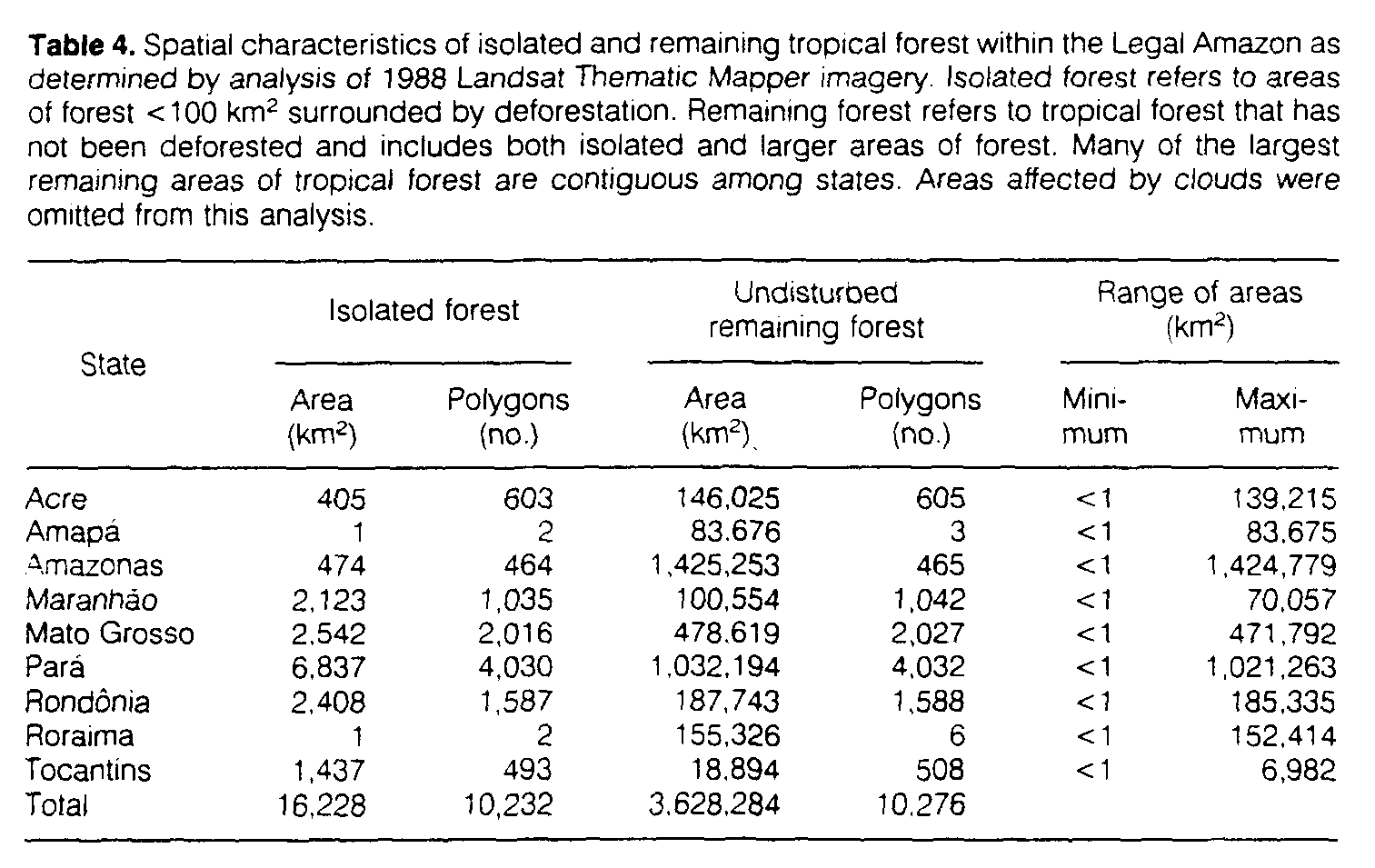
Our analysis of the spatial pattern of deforestation found a strong tendency toward spatial concentration; areas of undisturbed tropical forest tended to be sizable (Table 4). This is more pronounced than Table 4 indicates because many of the large areas of undisturbed tropical forest are contiguous among states.
For the entire Brazilian Amazon, our deforestation estimate is close to, but lower than, the estimates of Fearnside et al. (13) and the INPE (15) of ~280,000 km2 as of 1988. The difference is a result of three factors: (i) different stratification of forest, cerrado, and water; (ii) slightly different estimates of secondary growth, which is spectrally similar to intact forest in channel five; and (iii) positional accuracy, interpretation, and boundary generalization. We estimate that ~30,000 km2 of the difference is from a different evaluation of the forest-cerrado boundaries in Mato Grosso and Tocantins. By comparison, our analysis suggests that deforestation estimates based on coarse-resolution meteorological satellite data in the southern Amazon of Brazil have overestimated deforestation by ~50% (18, 23).
The average deforestation rate in the closed-canopy forests from 1978 to 1988 (~15,000 km2 year-l) (Table 3) is higher than the rate from 1975 to 1978 (3) but considerably lower than recent estimates (2, 4, 5, 20). Our estimates can be used in assessments of net flux of carbon from land clearing and biomass burning in the Brazilian Amazon. Current estimates of these fluxes have largely been based on model calculations with deforestation values much higher than we report. In addition, many deforested areas are in stages of regrowth following abandonment (26). If regrowth is widespread, estimates of the net flux of carbon should be further reduced because carbon accumulates in regrowing biomass.
The preponderance of affected habitat results from proximity to areas of deforestation (~341,000 km2 for a 1-km edge effect) and not from isolation of forest (~15,000 km2) or deforestation per se (~230,000 km2). While the rate of deforestation averaged ~l5,000 km2 year-1 in the Brazilian Amazonia from 1978 to 1988, the rate of habitat fragmentation and degradation was ~38,000 km2 year-l. Implications for biological diversity are not encouraging and provide added impetus for the minimization of tropical deforestation.
2. N. Myers, Clim. Change 19, 3 (1991).
7. R. A Houghton, Clim. Change 19, 99 (1991).
17. P. M. Fearnside, Environ. Conserv. 17, 213 (1990).
23. D. L. Skole, thesis, University of New Hampshire (1992).