 Reproduced, with permission, from:
Helldén, U. 1988. Desertification monitoring: Is the desert encroaching? Desertification Control Bulletin 17: 8-12.
Reproduced, with permission, from:
Helldén, U. 1988. Desertification monitoring: Is the desert encroaching? Desertification Control Bulletin 17: 8-12.
Ulf HelldénRemote Sensing Laboratory Department of Physical Geography, University of Lund Soelvegatan 13, S-223 62 Lund Sweden
This study is one of several carried out within the project "Regional Studies of Desertification and Its Control" initiated during 1981 in co-operation with the University of Khartoum. Sudan and completed in 1985. Its general goal was to develop, test and apply monitoring methods, for the understanding and prediction of desertification (Ref. 1). The Sahelian pre-drought, drought and post-drought period 1961-1979 and the Province Northern Kordofan was the focus of the project.
It was sponsored by The Swedish Agency for Research Cooperation with Developing Countries (SAREC) and the Swedish Board for Space Activities.
--Desertification is the diminution or destruction of the biological potential of the land, and can lead ultimately to desert like conditions (Ref. 2)
--Desertification can also be described as a process of impoverishment of arid, semiarid and some sub-humid ecosystems by the combined impacts of man's activities and drought (Ref. 3).
--Desertification has also been defined as a process leading to reduced biological productivity, with consequent reduction in plant biomass, in the land's carrying capacity for livestock. in crop yields and human well being leading to the intensification or extension of desert conditions (Ref. 4).
--Desertification (desertization) was defined as the spread of desert-like conditions in arid or semi-arid areas due to man's influence or to climatic change by Ref. 5.
It is implicitly understood that desertification leads to long lasting and possibly irreversible desert like conditions. "Decreasing productivity" is a key process included implicitly or explicitly in all definitions.
The impact of desertification and its causes in north Kordofan were described in several reports during the 1970's following the 1964-74 Sahelian drought. For example:
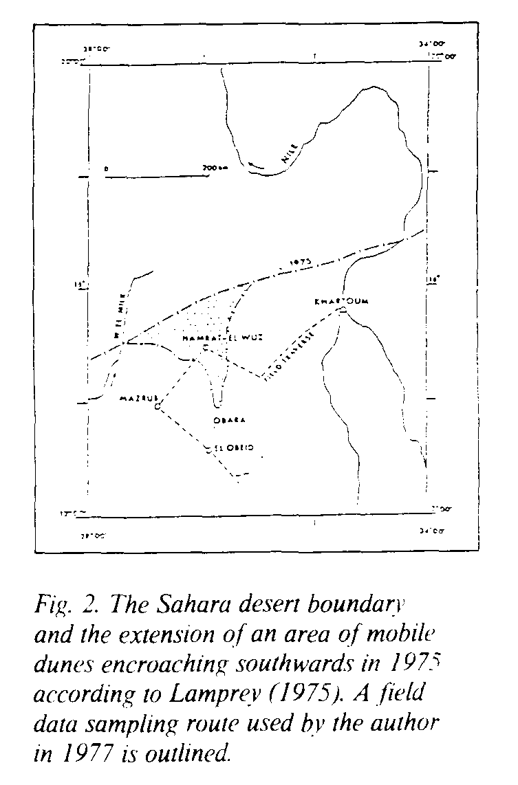
"It is evident that the desert southern boundary has shifted south by an average of about 90-100 km in the last 17 years...in several areas, particularly in northern Kordofan in the Hamrat El Wuz and Kheiran areas, sand encroachment has moved rapidly ahead of the southern boundary of the desert and loose sand is accumulating over the formerly consolidated sandy (and locally clay) soils...Shallow sand encroachment appears to have killed nearly all vegetation except the trees Acacia tortilis and Balanites aegyptica and a small number of dune adapted shrubs as far south as 15 N in the Hamrat El Wuz area. Immediately south of this area mobile dunes are moving southwards with the prevailing wind and are becoming an increasingly serious threat to the agricultural land and several villages in the Bashiri and Bara areas of the Kheiran region. The sand dunes are being augmented by the very large area of drifting sand further north near Hamrat El Wuz." (Ref. 6, p.4-6). This is a commonly accepted description of desertification in Kordofan reproduced e.g. by Refs. 7-9. It was even stated by Ref. 10 that: "Surveys have shown that the desert had advanced 90-100 km within a 17 years period and is currently advancing at the rate of 5 to 6 km per year".
A severe effect of the described desertification is declining food and meat production. "Food production has declined and continues to decline because of soil deterioration associated with desert encroachment and because of loss of land. especially land buried by sand." (Ref. 11., p.4).
Ref. 12, referring to Ref. 6, stated that the desert is continuing to move southwards at a rate of 5-6 km per year. It was also stated that desertification is spreading like cancer in other areas including the adjacent low rainfall savanna and that it is quite clear that desert encroachment in the Sudan is mainly a man made phenomenon caused by the misuse of land. Cultivation in marginal areas was assumed to be one of the main causes of desertification.
"...that the desert's edge is gradually shifting southward there is little doubt. The spread of the Sahara has probably been measured most precisely in Sudan. There, as elsewhere, vegetational zones are shifting southward as a result of overgrazing, woodcutting and accelerated soil erosion. Steppe loses ground to the desert, it creeps into the neighbouring savanna which, in turn, creeps into the forest" (Ref. 13).
Overcultivation has been mentioned as a major cause of desertification by Ref. 8. The matter is described in the following way by Ref. 14 (p.31): "Field study has firmly convinced us that transgression over the potential, i.e. climatically controlled border of millet cultivation, is the major factor in the process of desertification in Northern Darfur". It was stated by Ref. 15, (p.247): "Though the impression is created as if the desert was creeping southwards with the north-eastern Trade Winds the sands actually originate from the Qoz-belt itself, mobilized by intensive cultivation". This opinion contradicts the one presented by e.g. Refs. 6, 12, and 13.
Another mechanism of desertification described in the literature includes the expansion of existing vegetation-stripped village and water hole perimeters generated through overgrazing and wood cutting (Refs. 16, 9, 5, 17). When several village "desert patches" coalesce a local or regional desert is created. According to Ref 18 it could be proved, by the heir of satellite photographs, that desert expansion proceeds by way of forming new marginal islands around the villages of the settled cultivators in the Sahelian zone of the Sudan.
However, it was not possible to verify this concept of desertification in north Kordofan in the present project. The following section is condensed from Ref. 19.
A stratification of a transect through N. Kordofan was carried out based on Landsat false colour composites (FCC) (188/49, 51, 52) and one MSS 5 image (188/50) recorded Nov. 9, 1972 and compared with a corresponding stratification based on Landsat imagery (MSS 5 and RBV imagery) recorded Jan. 25, 1979 (Fig.1). All imagery was in the original scale of 1:1 million superimposed on maps of the same scale.
The desert boundary, defined as the border between semi-desert bush/shrub and grassland and with a more or less continuous vegetation cover, and areas with no or very scattered vegetation cover were mapped together with a delineation of other strata. It was not possible to identify any significant shifts in borders between 1972 and 1979. Neither was it possible to find any significant differences in the delineation of the desert margin/semi-desert when the maps were compared to the location of the desert margin as it was presented by Ref. 20, based on Landsat imagery from 1976, or as it was presented by Refs. 21-22. The border coincides roughly with the 100 mm isohyet at latitude 16 degrees North.
The 1975 desert boundary was mapped by Lamprey (Ref. 6) and compared with the one presented on a vegetation map of the Sudan by Ref. 23 in 1958. Lamprey based his map on a combination of reconnaissance flights and ground based surveys from a car. He concluded that the Sahara desert had advanced 90-100 km between 1958 and 1975. The 1975 border fluctuates around latitude 16 degrees N roughly corresponding to the 100 mm isohyet and in rough accordance with the Landsat based results presented above.
It seems, however, that the desert boundary described in the vegetation map of Ref. 23 from 1958 was defined to follow the 75 mm isohyet, located 90-100 km north of the 100 mm isohyet, rather than actually mapped (Ref. 12). It might explain why Lamprey found the 1958 desert boundary to be located 90-100 km north of the boundary defined by himself in 1975. There does not seem to be any evidence for the Lamprey conclusion that the Sahara desert had advanced 90-100 km in the area during the period 1958-1975. The vast Sahara dune complex encroachment mapped by Ref. 6 could not be found (Cf. Fig. 2)
In the study by the author, the extension of cultivated fields was mapped through interpretation of the 1972 and 1979 Landsat imagery to the scale of 1:1 million. The proportion of the Qoz zone considered to be under cultivation inside the transect was assessed for 1972. 1976 (recalculated from data presented by Ref. 21) and 1979. The proportions are 21%, 14% and 14% respectively. There is a good correspondence between these data and data for Northern Kordofan recalculated from the official agricultural statistics.
A 6,000 sq km area located in the centre of an old core area of cultivation was mapped to the scale of 1:500.000 through interpretation of the Landsat 1972 and 1979 imagery and compared to a map of cultivated fields based on interpretation of air photos (approximate scale 1:48,000) recorded in 1962. The proportion of cultivated land for the years 1962, 1972. 1976 (Ref. 21) and 1979 in the most intensively cultivated zone of the transect was 25%, 22%, 24% and 29% respectively. By adding the 1962, 1972 and 1979 maps to each other it was indicated that 40-50% of the land in this zone was used in the cultivation--fallow rotational process while half the area was never used for cultivation.
Precipitation data (annual and the sum of July-September), proportions of cultivated Qoz land, variation of yield and production for the staple food crops millet and sorghum together with estimates of the areas used to grow these crops for the period 1962-1978 were plotted in graphs. An explosive expansion of the areas cultivated was noted at the end of the 1960's in the middle of the Sahelian drought, followed by a decrease after the drought. The expansion can hardly be explained by a population increase during this short period. The fact that the major part of the Sudan Government water supply programme was implemented during the 1960's can possibly explain some of the increase. Almost 300 wells (bore holes) were opened during 1968-73 which is 51% of all the wells opened during the period 1919-1982 (581 wells), according to Ref. 24. The availability of new water resources might have resulted in the cultivation of areas which could not be reached before because of lack of water for the labour.
It seems that the farmers succeeded in keeping up food production fairly well during the drought in spite of declining yields. It was demonstrated by Ref. 25 that 85% of the variation in millet crop yields in Northern Kordofan could be explained by rainfall parameters during the 1952-1980 period. The very drastic expansion of the areas under cultivation at the end of the 1960's is a possible response by the farmer to declining crop productivity caused by drought. Analysis of the data indicates that the size of the areas under millet production in a specific year can be described as a linear function of the average yield of millet and sorghum for the two preceeding years in the time series 1962-1978. The multiple regression explains 81% of the millet area variation.
No significant northward transgression of the cultivation limit was noted between 1972 and 1979. It was found around latitude 14.5 degrees N on all Landsat data (1972, 1976, 1979). Ref. 26 considered in 1877 that almost all millet grown in Northern Kordofan could be found between latitude 13 degrees N and 14.5 degrees N. He stated that 800-900 seasonal wells were distributed over the area and that every square metre will produce but that probably only 1/5th of the land was planted. The reliability of the area assessment is of course very uncertain. It indicates that the proportion of Qoz land under cultivation, more than 100 years ago. might have been as high or even higher than it was in 1979.
To follow the development and possible increase of desertifed area surrounding villages and water holes, 77 villages, most of them located within the old core of intensive cultivation, were identified on air photos from 1962 and digital Landsat data from February 1973 and January 1979 and RBV imagery recorded January 1979. The 1973 Landsat MSS data were registered to the 1979 data through a nearest neighbour resampling. The residual error (X and Y) was assessed to less than half a pixel. The maximum width of existing perimeters were measured together with village diameters. The type (fula, well, borehole, hafir, water yard) and number of water sources available in each village were noted and the total water resources available in each village was assessed on a nominal scale. The water resources data were obtained from Refs 27 and 24. Possible relations and trends were studied through multiple correlation and variance analysis.
It was not possible to find any systematic change in the size of the perimeters for the periods studied. Just 7 out of the 77 village perimeters indicated a significant (95%-level) expansion. The size of existing perimeters could not be related to the size of corresponding villages. However, a relationship seems to exist between water resources available in a village and the width of its perimeter. It was indicated that some of the fluctuations in the size of the village perimeters can even be a result of rotational land use.
Kheiran is the name of a large dune complex elongated in North-South direction about 80 km x 15 km and located west and north-west of Bara forming the southernmost end of the dune front indicated in Fig. 2. "Kheiran" is the plural form of "Khor" meaning depression. The area is made up of transversal dune ridges (E-W) and interdunal depressions. The major part of the area is covered by vegetation. In 1911 Ref. 28 reported the area to be covered by tufts of coarse grass and scattered Marrakh (Leptadenia spartium/Leptadenia pyrotechnica) serving to keep the dunes stationary. Vegetation free dunes were reported around El Tawil and El Hamra as early as 1911.
In 1911 Ref. 28 assumed the Kheiran to represent the bed of an ancient stream rising in the Umm Durrag and Abu Hadid hills and losing itself on the level plains round El Obeid. He even suggested that the whole country covered by undulations was once a lake fed by streams from surrounding areas. According to Ref. 28 native tradition said that Kheiran was once a "bahr" (lake).
Ref. 29, 1937, was perhaps the first one to introduce the perception that Kheiran was an active Sahara dune complex lobe pushing the people southwards. He described the southern parts of Kheiran as a deforested and heavily grazed area with many active crescent dunes.
Kheiran has attracted people, at least since the beginning of the 19th century, because the ground water in the interdunal depressions is very close to the surface. According to Ref. 28 there were some 150 interdunal basins with a potential for irrigated cultivation in 1911. About 100 of the 150 were used for irrigated cultivation during the Turkish Government rule 1822-1882. Good access labour in the form of slaves was an important factor in the agricultural development. In winter 1910/1911 only 49 were irrigated. The decrease is explained by Ref. 28 as historical/political events and not by land degradation. Ref. 16 estimated some 40-45 depressions were under irrigated cultivation in the mid 60's implying that human exploitation pressure was probably higher or at least as high 150 years ago as it was during the Sahelian pre-drought, drought and post-drought period 1961 - 1979.
Air photos from 1962, Landsat MSS data recorded in October 1972. January 1973, January 1979 and October 1979 were used for a study of the barren dune field in the southern part of Kheiran. The dune field is located at the southernmost tip of the large dune complex mapped by Ref. 6 in 1974 and described as the front of active sand encroachment from the Sahara desert (Cf. Fig. 2).
All MSS data were precision corrected through a third order polynomial transform and registered to the October 1979 data using a nearest neighbour resampling algorithm. X and Y residual errors were less than 0.5 pixels.
No southward dune complex encroachment was found. Some new non-vegetated dunes were created in the south through vegetation clearing. followed by cultivation, on fossil dunes especially between 1962 and 1972.
As already mentioned, vegetation free dunes in the southern part of the Kheiran area was reported as early as 1911 (Ref. 28). It was reported that sand dunes around El Tawil seemed to gradually encroach southwards over the basin at the foot of the ridge. The El Tawil basin has been under irrigated cultivation ever since the beginning of the 19th century and is still not buried by sand. The land between Hamrat El Wuz and the barren dunes in southern Kheiran was covered by vegetation in 1972, 1979 according to Landsat data and in 1977, 1980, 1982 and 1983 according to field surveys in the area carried out by the author. There are no signs of an active sand creep connection between the Sahara and the barren dunes in southern Kheiran.
It was NOT possible to verify that:
--desertification takes place through a systematic Sahara desert boundary encroachment
--any major and systematic sand dune complex encroachment takes place.
--desertification takes place through a systematic expansion of desertified village/water hole perimeters.
--variations in crop yield and food production indicated desertification or that these variations are caused by a systematic expansion of cultivation into marginal and vulnerable lands.
--there has been significant northward transgression of the cultivation limit during the past 100 years.
There was no creation of long lasting desert-like conditions during the 1962-1979 period in the area corresponding to the magnitude described by many authors. There was however a severe drought impact on crop yield during the Sahelian drought 1964-1974. The drought effects on the natural vegetation productivity was most probably of the same magnitude. The impact of the Sahelian drought was short lasting followed by a fast land productivity recovery.
References
18. Ibrahim, F.N., 1979. Desertification. A world-wide problem. Haqeman. Item No. 17 16 60, 30 pp.
24. Rural Water Corporation, 1983. Wells archive at the Rural Water Corporation, El Obeid, Sudan.
28. MacMichael, H.A., 1911. The Kheiran. Sudan Notes and Records, III(4).
29. Smith, J., 1937. The Kordofan Gum Industry. Ministry of Energy, Khartoum Sudan.