 Reproduced, with permission, from:
Dregne, H. E. 1986. Desertification of arid lands. In Physics of desertification, ed. F. El-Baz and M. H. A. Hassan. Dordrecht, The Netherlands: Martinus, Nijhoff.
Reproduced, with permission, from:
Dregne, H. E. 1986. Desertification of arid lands. In Physics of desertification, ed. F. El-Baz and M. H. A. Hassan. Dordrecht, The Netherlands: Martinus, Nijhoff.
ABSTRACT
Desertification is a land degradation problem of major importance in the arid regions of the world. Deterioration in soil and plant cover have adversely affected nearly 50 percent of the land areas as the result of human mismanagement of cultivated and range lands. North America and Spain have the largest percentage of their arid lands affected. Overgrazing and woodcutting are responsible for most of the desertification of rangelands, cultivation practices inducing accelerated water and wind erosion are most responsible in the rain-fed croplands, and improper water management leading to salinization is the cause of the deterioration of irrigated lands. In addition to vegetation deterioration, erosion, and salinization, desertification effects can be seen in loss of soil fertility, soil compaction, and soil crusting. Urbanization, mining, and recreation are having adverse effects on the land of the same kind as is seen on range, dry farming, and irrigated lands. Combating desertification can be done successfully using techniques already known if financial resources are available and the political will to act is present.
Desertification of the arid lands of the world has been proceeding--sometimes rapidly, sometimes slowly--for more than a thousand years. It has caused untold misery among those most directly affected, yet environmental destruction continues. Until recently, few if any lessons seemed to have been learned from the past, in part because the problem was an insidious one that went unrecognized in its early stages or was seen as a local one affecting only a small population, and in part because new land was always available to start over again. As long as remedial action could be deferred by moving on to new frontiers, land conservation had little appeal. It was not until the 20th century--when easy land expansion came to an end--that governments and people finally realized that continued careless degradation of natural resources threatened their future.
INTERNATIONAL DIRECTIONS
The decade of the 1950's witnessed the first worldwide effort to call attention to the problems and potentials of arid regions. It started when the United Nations Educational, Scientific, and Cultural Organization (UNESCO) launched its Major Project on Scientific Research on Arid Lands in 1951. That project led to publication of a newsletter, the provision for funds for establishing and strengthening arid land research institutes, organization of conferences and symposia, and publication of a series of research reviews and special reports on a wide range of topics. The Major Project was terminated in 1962 and the arid land program was merged with the broader UNESCO natural resource program.
The impetus generated by the UNESCO project led to expanded interest in, and support of, arid lands studies throughout the world. By 1970, knowledgeable scientists were well aware of the magnitude of the land destruction that had taken place in the past, and that was becoming even more serious as population pressures increased.
At about the same time, one event served to focus world attention on desertification: the 1969 to 1973 drought in the African Sahel. Recognition of the severity of the drought affecting six countries on the southern border of the Sahara (Mauritania, Senegal, Mali, Upper Volta, Niger, and Chad) was slow to develop. Droughts, after all, were not unusual in the Sahelian countries; an equally bad or even worse one had struck the same region during the years from 1911 to 1914, and several other droughts had occurred before and after that time. It was only when the situation had become catastrophic that relief measures were undertaken on a large scale. Among the aftereffects of the human toll and the millions of livestock that died due to the drought, was the call by the United Nations General Assembly for the convening of an International Conference on Desertification. The conference was held in Nairobi, Kenya, in August and September of 1977, attended by representatives of nearly 100 nations and many international organizations; governmental and nongovernmental. In addition to providing a forum by which the world's attention was drawn to the land destruction that was occurring, the conference addressed the problem of combating desertification of arid lands. A plan of action was drawn to the land destruction that was developed and approved by the delegates (United Nations, 1978). Responsibility for following up and coordinating the implementation of the Plan of Action to Combat Desertification was entrusted to the United Nations Environment Program.
DEFINITION
Desertification is a term that has been in use since at least 1949 when Aubreville, a perceptive and well-informed botanist and ecologist, published a book on "Climate, Forets, et Desertification de l'Afrique Tropicale" (Aubreville, 1949). Aubreville thought of desertification as the changing of productive land into a desert as the result of ruination of land by man-induced soil erosion. He associated it with the humid and subhumid tropics where he worked. The causes of land destruction were tree cutting, indiscriminate use of fire, and cultivation, which exposed the soil to water and wind erosion. Desertification was not the result of the Sahara spreading outward but of localized activity that could begin anywhere. Aubreville was quite clear in his conclusion that desertification in tropical Africa was due to man's activity, and that there had been no significant climatic change during the past thousand or more years. Most of that destructive activity has occurred within recent historic time by the action of agricultural populations.
Despite the fact that a world conference has been held on the subject, there is no generally accepted definition of desertification. For most people, the word probably evokes a mental picture of a barren forbidding landscape resembling Death Valley or the Sahara. Fortunately, that grim picture does not apply to most of the land that has undergone desertification.
A definition of desertification should recognize that it is a land degradation process that involves a continuum of change, from slight to very severe degradation of the plant and soil resource, and is due to man's activities. The definition used here is the following:
Desertification is the impoverishment of terrestrial ecosystems under the impact of man. It is the process of deterioration in these ecosystems that can be measured by reduced productivity of desirable plants, undesirable alterations in the biomass and the diversity of the micro and macro fauna and flora, accelerated soil deterioration, and increased hazards for human occupancy.
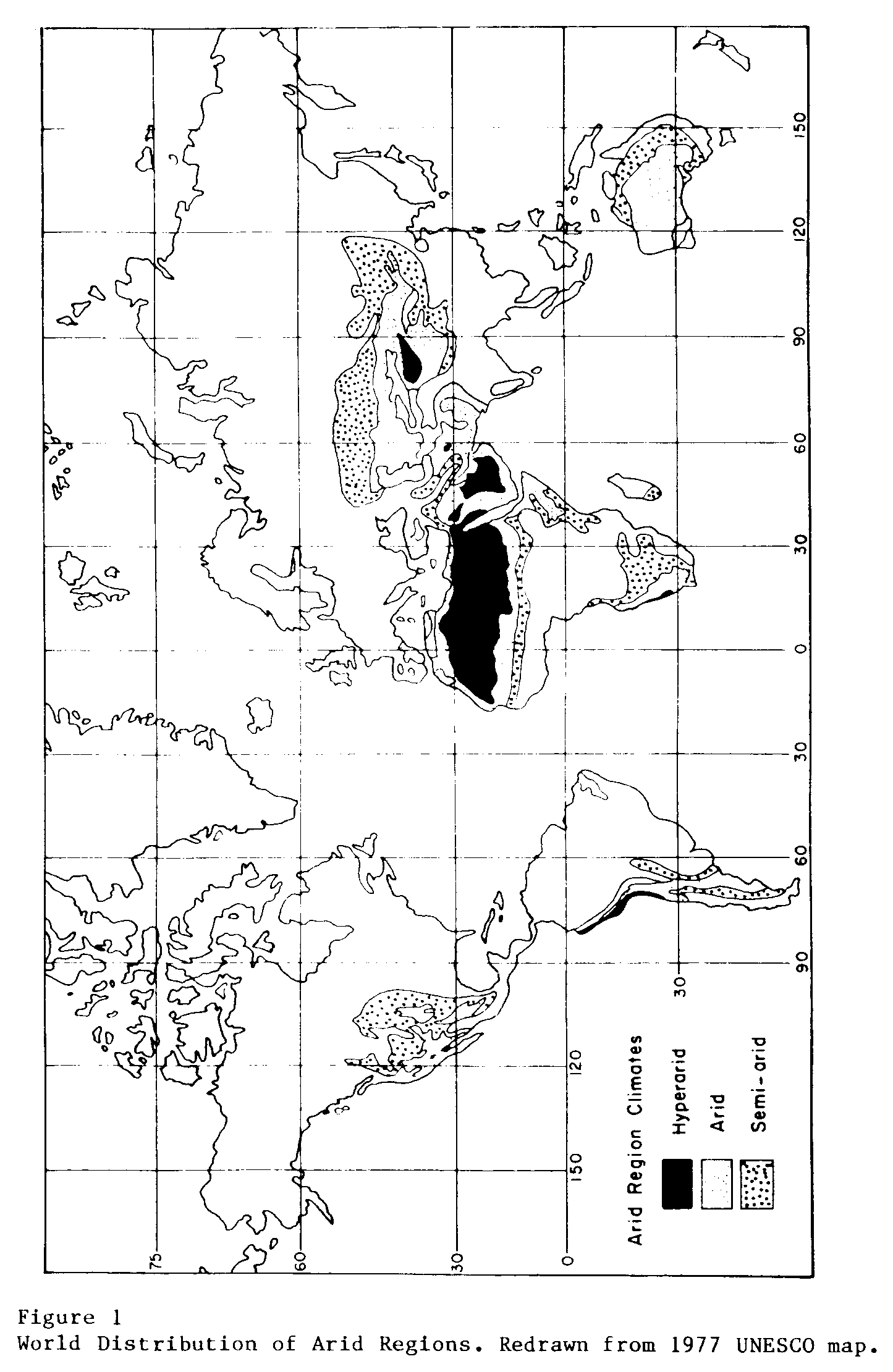
Figure 1 delimits the arid regions with which this monograph is concerned. The map is redrawn from a UNESCO map of the arid regions (UNESCO, 1977).
DESERT SPREAD AND DROUGHTS
A common misapprehension about desertification is that it spreads from a desert core, like a ripple on a pond. The truth is that land degradation can and does occur far from any climatic desert; the presence or absence of a nearby desert has no direct relation to desertification. Desertification usually begins as a spot on the land-scape where land abuse has become excessive. From that spot, which might be around a watering point or in a cultivated field, land degradation spreads outward if the abuse continues. Ultimately the spots may merge into a homogeneous area, but that is unusual on a large scale.
A second misconception is that droughts are responsible for desertification. Droughts do increase the likelihood that the rate of degradation will increase on non-irrigated land if the carrying capacity is exceeded. However, well-managed land will recover from droughts with minimal adverse effects when the rains return. The deadly combination is land abuse during good periods and its continuation during periods of deficient rainfall. The famous satellite photograph taken during the 1970's drought of a green rectangle (the Ekrafane Ranch) surrounded by brown denuded land in eastern Niger demonstrated dramatically the value of good range management during favorable and unfavorable years.
HISTORICAL DEVELOPMENT
Land degradation is by no means a new problem, despite the attention focused upon it in recent years. In some quarters, there is a tendency to blame desertification upon land pressures generated by the population explosion of the middle 20th century. While the rapidly expanding population has greatly exacerbated the situation, desertification is not a new phenomenon.
Historical evidence shows that serious and extensive land deterioration occurring several centuries ago in the arid regions had three epicenters: the Mediterranean Sea, The Mesopotamian Valley, and the loessial plateau of China. There were other places where destructive changes in soil and plant cover had occurred but they were small in extent or are not well known.
Last One Hundred Years
Desertification in Africa and elsewhere began long before the 1969-1973 drought struck the Sahel. Stebbing (1937a, 1937b) was the most persistent of those sounding the alarm over the rapid deforestation of the Sahelian and Sudanian vegetative zones. He looked upon desertification in West Africa as forest degradation that leads to erosion and, as a last stage, to barren sand or rock. That process is hastened, he contended, by blown sand from the Sahara being deposited on the deforested land. It was this latter activity that led him to refer to the "encroaching Sahara," a term he later regretted using (Stebbing, 1938). He disclaimed any attempt to give the idea that the Sahara was a vast sand field advancing in great waves like the incoming tide of a sea. The latter concept, however, has proved so attractive to numerous writers on desertification that it now represents a common view on the subject (Cloudsley-Thompson, 1974). There apparently is something fascinating about the idea of an expanding desert threatening mankind. Encroachment of moving sand dunes on desert oases and transportation routes is an aspect of desertification that is of small areal extent but is locally important and highly visible.
Warnings similar to those of Stebbing for the Sahel were made by other scientists in southern Africa, North America, South America, Asia, and Australia during the 1920's and 1930's. Research has been undertaken in many countries to develop techniques of grazing management and soil and water conservation that would halt and reverse desertification. As a result, there is now a good understanding of the basic principles of land conservation. Field application of those principles has been slow, unfortunately, and land degradation continues to undermine efforts to improve human well-being.
OCCURRENCE OF DESERTIFICATION
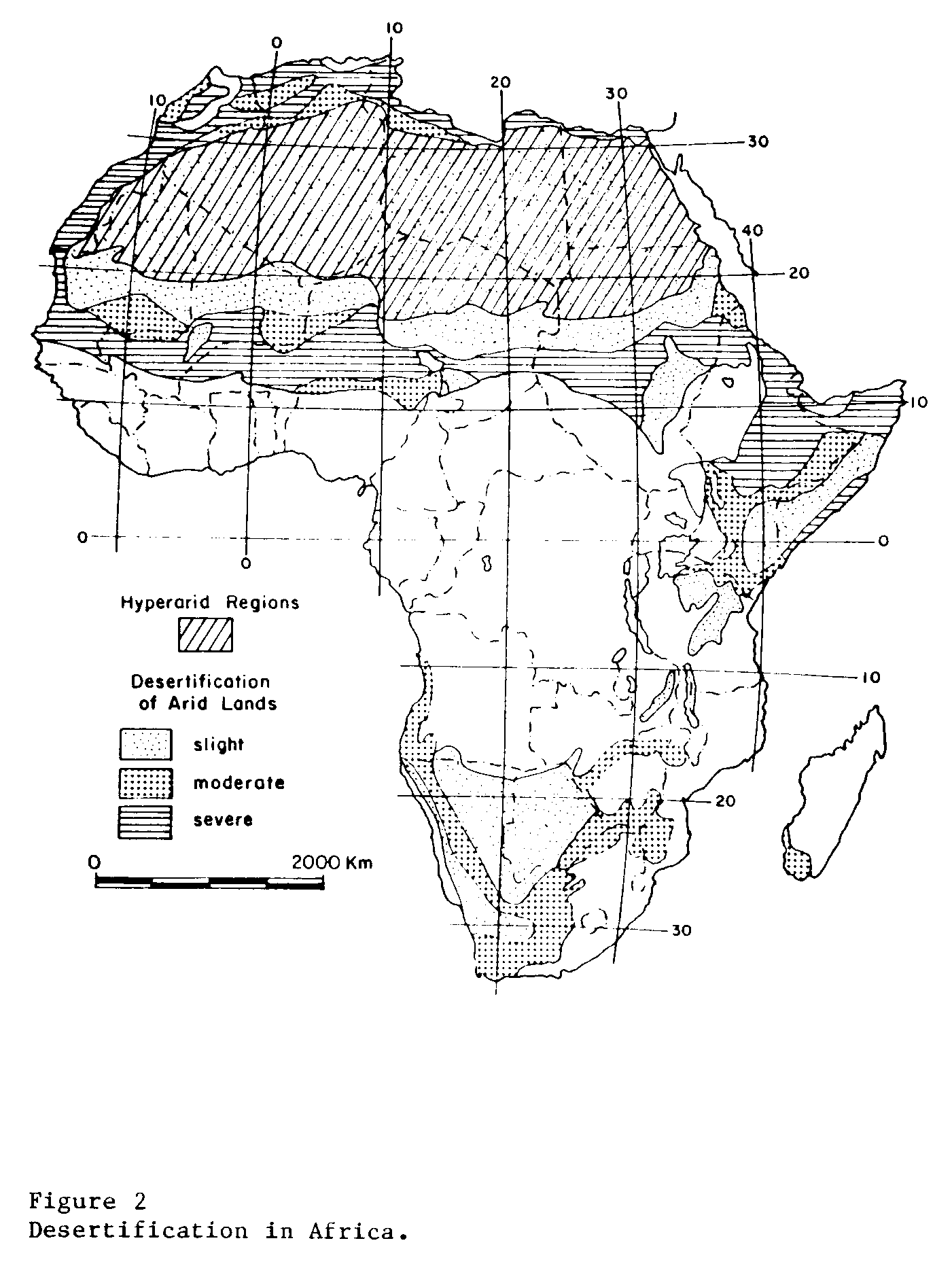
Desertification affects nearly all of the arid regions, to varying degrees, except for the extremely arid climatic deserts such as the Sahara, Atacama, and Taklimakan. An indication of the extent and intensity of the desertification that has occurred in the past is presented in Figures 23, 4, 5, 6 through 7.
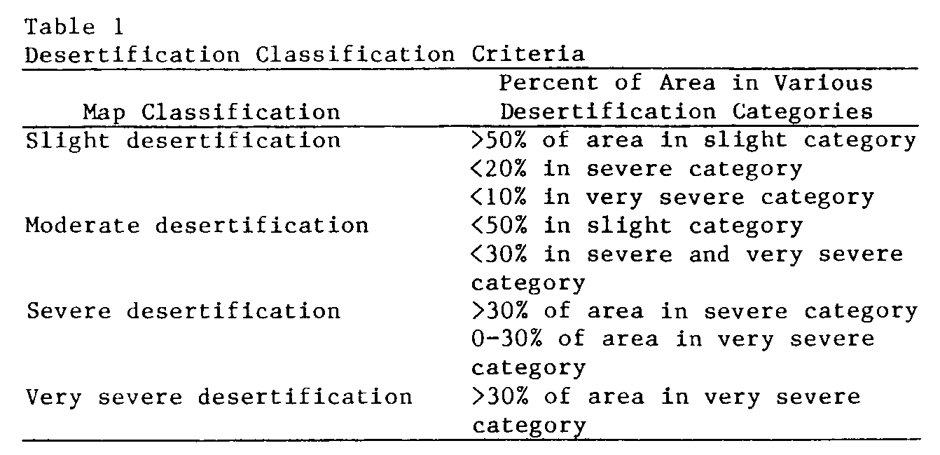
The classification system used in the preparation of continental desertification maps is based on four classes of desertification: slight, moderate, severe, and very severe. The criteria for each class are as follows:
Slight: Little or no degradation of the soil and plant cover has occurred.Moderate: (1) 26 to 50 percent of plant community consists of climax species, or (2) 25 to 75 percent of original topsoil lost, or (3) soil salinity has reduced crop yields 10 to 50 percent.
Severe: (1) 10 to 25 percent of plan community consists of climax species, or (2) erosion has removed all or practically all of the topsoil, or (3) salinity controllable by drainage and leaching has reduced crop yield by more than 50 percent.
Very Severe: (1) Less than 10 percent of plant community consists of climax species, or (2) land has many sand dunes or deep gullies, or (3) salt crusts have developed on very slow permeable irrigated soils.
The "very severe" category represents the extreme condition that many people associate with desertification. It is land so badly degraded that its utility by man or animals is virtually zero and the degradation is economically irreversible, for most purposes. While there are many small areas of land that fit into this category, there are few areas large enough to be shown on the continental maps. Practically all of the world's desertification can, at this point, be reversed.
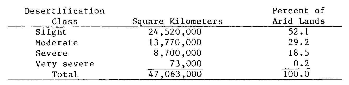
Delineations on the maps, because of the small scale employed, usually are combinations of different desertification classes, for example, and area shown as moderately desertified may have inclusions of slightly desertified and severely desertified land. The guidelines established to determine the map classification for any delineated area are given in Table 1. Table 2 gives data on the land area of the arid regions of the world in the four desertification classes. Most of the land used for agriculture in the arid regions is at least moderately desertified. The 52.1-percent figure for land in the category of slight desertification consists mainly of the naturally barren climatic deserts (hyperarid regions) where man's presence has been minimal.
AFRICA
The severe Sahelian drought that extended from through l969 focused the world's attention on the human aspects of land degradation and led to the convening of the 1977 United Nations Conference on Desertification. Drought, however, is not the cause of desertification; man is. The drought served only to place additional stress on the biological resources of the Sahel. If resource management has been good, little, if any, permanent damage is done by droughts. However, if resource management has been unwise, a drought accentuates the adverse impact of that management and accelerates land degradation (Weaver and Albertson, 1940). The latter is what has occurred widely in the Sahel and elsewhere.
All of the usual forms of desertification are present in the arid regions of the African continent and are manifested as serious local or regional problems (Figure 2). Overgrazing has reduced range productivity virtually everywhere outside the tsetse fly regions, in north, west, east, and south Africa. Wind and water erosion have devastated landscapes in the cultivated regions and in much of the rangelands (Rapp, 1974). Shortened fallow periods in the shifting cultivation system south of the Sahara have led to severe depletion of plant nutrients. Salinization and waterlogging of irrigated land is worst in the Nile Valley and North Africa but also occurs elsewhere. Mining has left surface scars wherever it is practiced. The environmental degradation continues and shows no sign of slowing down.
Desertification Characteristics
A number of factors have increased land degradation and the vulnerability of the African arid regions to desertification. Most of them have had similar effects in Asia and Latin America. They can be grouped in three categories: (1) increased human and animal population, (2) improved health services, and (3) injudicious use of technology.
Due to the increased sedentary population, pressures on cultivated land led to a shortening of the fallow period in the shifting cultivation cycle and the extension of cropping into the more precarious drier regions. Crop harvests became less reliable and more variable as the desert edge was approached. Concurrently, nomadic pastoralists were deprived of some of their best grazing lands as the cultivators moved in (Delwaulle, 1977). At the same time the rangeland area was contracting, populations of pastoralists and their livestock were increasing and the provision of improved veterinary services and the lack of a viable marketing system helped assure that animal numbers would grow rapidly (Widstrand, 1975). The result was inevitable: overgrazing and accelerated desertification.
Overgrazing inadvertently was made worse, particularly in the Sahel, by the drilling of additional wells that provided drinking water for livestock throughout the year. Without the rest period that intermittent water supplies previously assured, forage conditions deteriorated around the wells where water was no longer a limiting factor in livestock survival. Local authorities did not or could not impose a control system that would allow forage plants to recover from heavy grazing.
A crude estimate of the amount of crop yield reduction that could be attributed to salinization and waterlogging in the Nile Valley indicates it to be at least 17 percent on 80 to 90 percent of the old irrigated land. In the newly irrigated lands east and west of the delta, the figure is likely to be a minimum of 25 percent yield reduction. Both problems are serious ones that can become even more serious in the future if remedial measures are not taken. The situation in Algeria and Tunisia is similar to that in Egypt with respect to yield reductions.
Solutions to desertification problems in Africa are known-- and in general--can be implemented readily if resources are available to do so. An exploding population in the developing countries, however, means that land pressures will continue to build. Reducing livestock numbers in the grazing lands until forage productivity can be improved is very difficult, at best, and introducing range use controls on communal land is not easy. There is little likelihood that marginal dryfarm lands will be returned to pastoral use unless production on the better lands is increased enough to offset the loss of cultivated land. While the latter can be done, progress in that direction is very slow.
Destruction of woody vegetation has been hastened by the ever-increasing need for firewood to meet the demands of the larger population. The destruction is especially noticeable around the rapidly growing urban centers, where the circle of deforested lands gets larger every year (Delwaulle, 1973).
While desertification was a long-standing problem even in the absence of droughts, the gradually increasing vulnerability of the land made the impact of the inevitable droughts worse than ever (Dahl and Hjort, 1979). The factors responsible for that vulnerability are still operating, desertification continues, and future droughts will have ever-greater damaging effects.
Salt-affected soils are common in Tunisia and Algeria where both surface and well irrigation waters frequently are saline. Salinization is important in other irrigated areas but on a small scale.
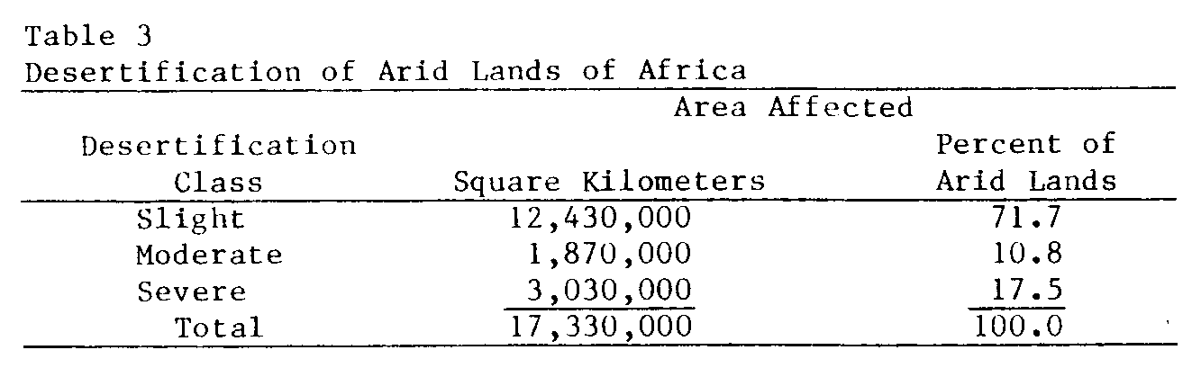
Magnitude of Desertification
About 18 percent of the arid region of Africa is severely desertified, and most of that represented by grazing lands and rain-fed cropping lands on the south side of the Sahara (Table 3). The other large area that is severely affected is the mountain slopes and the plains of North Africa. Moderate to high salinity affects about 30 percent of the irrigated land in Egypt (Aboukhaled et al., 1975).
Wind erosion is dominant in the drier regions and water erosion on the wetter sloping lands. Ethiopia, Kenya, and the Maghreb countries of Algeria, Morocco, and Tunisia have been subjected to especially serious water erosion, whereas wind erosion has been most damaging in sub-Saharan West Africa. While good data on the effect of land degradation on crop and livestock yields are not available, it seems likely that soil fertility losses, alone, have reduced dryland crop yields by 25 to 50 percent in the severely desertified areas. Animal productivity may well have declined by at least 50 percent nearly everywhere that domestic livestock are raised. In many areas south of the Sahara, rangeland forage production probably is less than 25 percent of the potential.
ASIA
Desertification in the arid regions of Asia is characterized by overgrazing of the rangelands of the Middle East and Central Asia, water erosion of cultivated lands from eastern China to the Mediterranean Sea, and salinization and waterlogging on a large scale in Iraq, Pakistan, China, and the Soviet Union. Mining (including oil and gas production) has caused severe land damage wherever it is carried on.
Overgrazing, soil erosion, and salt damage to irrigated land are long-standing problems in the Middle East and Central Asia, as is water erosion on the rain-fed cultivated lands of India, Pakistan, and the loessial plateau of China. Waterlogging and salinization are problems centuries old in the lower plain of the Yellow River in China, but are of relatively recent origin in the Indus Basin of Pakistan and India. Ameliorative measures to reduce land degradation have been undertaken in every country affected, with varying degrees of success. The problem is an immense one in terms of the area involved and the amount of degradation that has occurred (Figure 3).
Desertification Characteristics
Man first placed his imprint on the landscapes of Asia thousands of years ago. Historical records make it clear that the destructive impact of man was already apparent two or three thousand years ago in China and the Middle East. It was then that the first period of accelerated, man-made erosion began (Dregne, in press). Woodcutting and cultivation of sloping lands were responsible for most of the land degradation that occurred in the uplands of China and around the Fertile Crescent. Sedimentation of canals, waterlogging, and salinization combined to raise havoc in the Tigris and Euphrates valleys of Mesopotamia (Jacobsen and Adams, 1958).
Grazing pressure seems to have become a much greater problem in the past two or three decades than it was before. There has been an explosion of human and livestock population recently from India (Office of Environmental Planning and Coordination, 1977) to the Middle East (Pearse, 1971). Cultivation has been extended into pastoral lands, wells have been constructed to make pastures usable throughout the year, and improved transportation facilities have made formerly remote areas accessible to livestock. As a consequence, cropping has become a high-risk land use in the climatically marginal areas that formerly were the best grazing lands. At the same time, overgrazing of the remaining range lands is accelerated by the increased concentration of livestock on drier lands. Destruction of vegetative cover on sandy lands has led to widespread wind erosion, depletion of soil fertility, and the undertaking of expensive erosion control projects in China, Iran, Saudi Arabia, and elsewhere.
Magnitude of Desertification
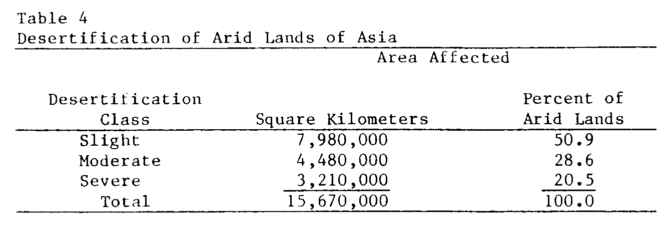
Asia has large areas where desertification is so severe that it borders on being classed as very severe desertification, but about half of the land is only slightly desertified (Table 4). Water erosion is spectacular in the loessial plateau in the middle reaches of the Yellow River. The eroded silt is sometimes so thick in the river that at Shanhsien, east of Xian, the sediment load has been measured at 46 percent. The river annually carries 1.3 billion tons of sediment, enough to cover 1,800 square kilometers of land 30 centimeters deep (de Crespigny, 1971). Virtually all of that represents loess eroded from 300,000 square kilometers of highlands. Efforts are being made to reduce erosion but the problem is so huge that progress is slow. Only the great thickness of the aeolian deposits has allowed cultivation to be continued on the eroding slopes.
Water erosion also approaches the spectacular on the slopes of the dryland farming areas of western India and northern Pakistan. Fortunately, the soils there are more resistant to displacement than in loessial material. Nevertheless, the damage--in the form of reduced yields--is serious nearly everywhere, and it is getting worse.
Salinization and waterlogging are as bad--and as difficult to control--in the irrigated region of southern Iraq as they are anywhere in the world. Deep fine-textured soils and almost flat topography make it hard to provide drainage that is adequate to maintain a deep water table and prevent salt accumulation. Techniques of soil and water management that are suitable for conditions in Iraq have been developed and tested successfully, but the technical problems are less difficult to resolve than the social ones (Dougrameji and Clor, 1977). Land reclamation is much easier on the more permeable soils of the Indus Valley and Central Asia.
Range productivity over most of the Middle East and western Pakistan is among the lowest in the arid world. A small beginning has been made in bringing the pastoral lands up to their potential productivity. Much remains to be done, however, because range management is only a young science in Asia. Recent emphasis on sand dune stabilization has led to a number of successful efforts to find effective methods and to identify adapted plants. Accomplishments have been outstanding, under very difficult circumstances.
A rapidly growing population and limited land resources mean that combating desertification will be difficult for the developing nations of Asia and very difficult for the poor countries. Land pressures must somehow be relieved, and that can only be accomplished by raising productivity and yields per unit area. A start can be made with presently available knowledge, but research and training will be needed to broaden the knowledge base and to provide guidance to the pastoralists and cultivators.
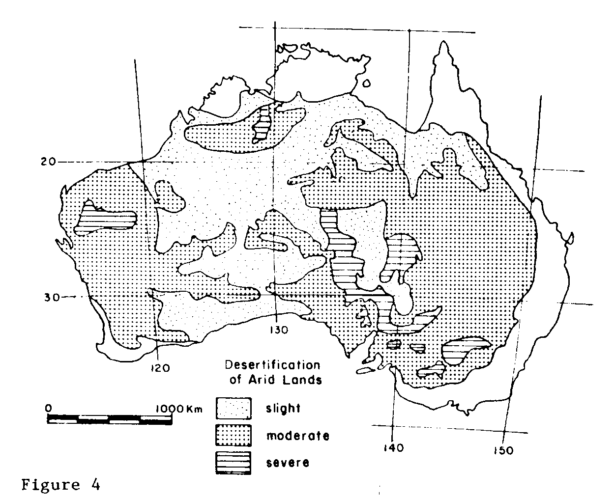
AUSTRALIA
Land degradation in Australia is, from the standpoint of area affected, a problem of overgrazing of range lands. Window and water erosion and salinization of irrigated and nonirrigated land are serious locally, primarily in small areas across the southern part of the continent, and their economic impact probably exceeds that due to overgrazing. Land degradation is usual around farming communities and popular tourist areas such as Ayers Rock.
Overgrazing began 50 to 100 years ago with settlement of the interior arid lands at a time when there was no information on the carrying capacity of range land, and little knowledge of climatic averages and extremes. During the first quarter of the 20th century, problems of wind and water erosion, salinization and waterlogging of irrigated land, and saline seepage of dryland areas arose as cultivation spread into the drier areas. Remedial action was undertaken on a concerted basis in the 1930s and l940s when states enacted soil conservation legislation and established units to correct land abuses and prevent further deterioration. At present, it probably is safe to say that overgrazing is much less of a problem than it was before 1940, that wind and water erosion still occur but to a lesser degree than before, that salinization of irrigated land in the Murray River catchment (watershed) is increasing, and that saline seepage of semiarid and subhumid lands is expanding steadily.
Desertification Characteristics
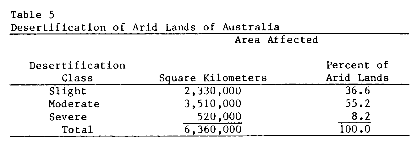
About 25 percent of Australia's arid regions are unoccupied (Condon, 1978) due to the unpalatability of spinifex grasses or to the remoteness of the land from population centers. Most of the remaining 75 percent is moderately desertified (Figure 4). Severe desertification is most extensive in the saltbush-bluebush (Atriplex-Maireana) vegetation type occurring in New South Wales and South Australia, where overgrazing has caused degeneration of the plant cover. Degradation of the vegetation due to overgrazing has also been severe on the fine-textured lowland soils (Vertisols) of eastern Australia and in the flood plains and surrounding slopes of coastal river valleys, particularly the Gascoyne, Ord, and Victoria catchments in Western Australia and the Northern Territory. Gully erosion has been severe on the Ord River catchment and significant on the other catchments, with greatly increased runoff where the trampling of livestock has developed water-repellent surface crusts. The presence of large numbers of feral donkeys in the Victoria River watershed compounds the problem of grazing control there.
Areas delineated on the map as severely desertified are not uniformly degraded. The typical spotty character of desertification shows up in river catchments as badly overgrazed and gullied land on flood plains and on the gentle slopes adjoining them, with moderately desertified areas in the less accessible parts of those shrub steppe zones.
Distribution of saline seeps on drylands, and salinized and waterlogged irrigated lands (Mabbutt, 1978), is also spotty. Seepage of salt-laden water on slopes has plagued cultivated lands in the semiarid and subhumid regions of Western Australia, South Australia, New South Wales, and Victoria for decades. The resulting saline soils on lower slopes and in waterlogged depressions ordinarily cover a few or several hectares and are surrounded by nonsaline soils. In Western Australia where the problem is most acute, seepage of saline groundwater into streams has also had a significant adverse effect on water quality.
Waterlogging in the Murray River and its tributaries is characterized by groundwater mounds affecting tens of thousands of hectares of irrigated land (Pels, 1978). The high groundwater levels lead to secondary salinization of soils as the salts originally present in the subsoils are carried to the surface through evaporation from the shallow water tables. Since waterlogging and salinization are functions of the irrigation water management and the presence or absence of a drainage system, salty land is interspersed with nonsalty land.
Wind and water erosion have been severe in the past but are less so now, by and large. Wind erosion is an old problem in the grazing and cultivated lands of New South Wales (Wagner, 1978) and the wheat lands of the Murray Mallee (Matheson, 1978). One of the special problems in the semiarid Australia is the appearance of "scalds," when sandy surface soils are blown or washed away and the slowly permeable subsoil of texture-contrast (duplex) soils is exposed. Revegetating scalds is difficult unless steps are taken to impound water on the surface. Mining towns such as Broken Hill have experienced accelerated wind erosion and dust storms as the land around the towns was denuded of vegetation.
Magnitude of Desertification
A 1969 report on land degradation in Australia (Newman and Condon, 1969) included an estimate that about 14 percent of the arid rangelands were severely degenerated in pastoral value, 23 percent were moderately degenerated, and 63 percent showed minor, little, or no degradation. Condon (1978) notes that much of the serious erosion and degeneration of rangelands that was evident until the late 1940s was a consequence of heavy use during the late 1800s. Since the 1940s there has been considerable improvement in range conditions, partly due to abnormally favorable rainfall over the last thirty years. The magnitude of desertification in Australia is shown in Table 5.
About 1 percent of the cultivated land in Western Australia is affected by saline seepage, with lesser percentages affected in the other states. Northcote and Skene (1972) estimate that 85,000 hectares of irrigated land in Australia are salt-affected, most of it in the Murray Basin. They also state that at least 197,000 hectares of dryland are affected by secondary salinization. Waterlogging and salinization go hand-in-hand in the Murray region.
Techniques to control desertification are well-known in Australia, the problem is recognized as a serious one, and state agencies are available to assist in carrying out reclamation and prevention programs. Grazing pressure probably has been reduced by half since the late 1800s and early 1900s and wind and water erosion in the more populous southern part of the continent is much less of a problem now. Soil salinity and waterlogging are more difficult to control because of the cost arising from the special conditions in the Murray irrigated area. One method used to dispose of saline drainage water without increasing the salinity of the Murray River water downstream is to divert it into evaporation basins. The principle is good but the cost is high and there are uncertainties about future contamination of groundwater by effluents from the basins.
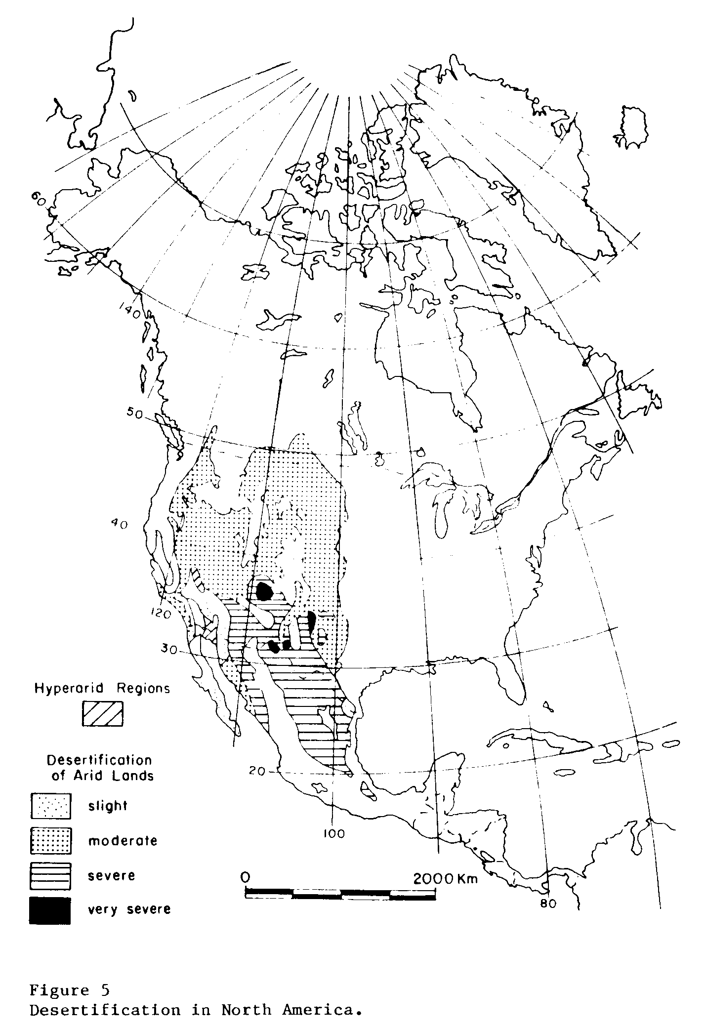
NORTH AMERICA
Overgrazing has left a lasting imprint on the arid lands of North America, and little has been accomplished in attempts to restore the land to its original productivity. Wind and water erosion are extensive and salinization and waterlogging-- of varying degrees of severity--are common in nearly all of the irrigated valleys. At present, desertification probably has been stabilized, with some improvement in plant cover of rangelands and in control of erosion and waterlogging over the past 30 years. Salinization of irrigated land is still occurring and the dryland saline seep problem is getting worse.
The overgrazing that destroyed or severely altered the original grass cover of the rangelands of Mexico and the United States began in Mexico after the Spanish conquest and spread into the U.S. Southwest. By the early part of the l9th century, overgrazing was already a fact on both sides of the international boundary. With the explosive expansion of cattle numbers in the Southwest when the railroads arrived, range carrying capacities were greatly exceeded, and that situation continued well into the 20th century. The increased gully (arroyo) formation that occurred in overgrazed rangelands during the latter part of the l9th century has been associated with range deterioration, erosion, salinization, and waterlogging first received attention from research organizations in the late 1800s and early l900s. Many of the basic principles for controlling desertification were established at that time. However, application of the principles did not become widespread until the 1940s and 195Os. Even though solutions are available now, much remains to be done to put them into practice.
Desertification Characteristics
There are about 450 million hectares in the arid regions of Canada, the United States, and Mexico. Approximately two-thirds of that total is moderately desertified and less than one-third severely desertified, with a considerable area of slightly desertified land and four small delineations of very severely desertified land (Figure 5).
In general, rangelands are moderately desertified in the north and severely desertified in the south. The dividing line approximates the ecotone between sagebrush (cool climate) and creosote bush (hot climate). Desertification is the result of a combination of overgrazing and water erosion. The four delineations of very severely desertified land on the map are in rangelands. Three of those four areas in New Mexico, Texas, and Chihuahua suffered first from overgrazing, then from wind erosion. The result is small hummocks of mesquite-topped sand dunes separated by completely barren blow-outs. The fourth-- and largest--of the very severely desertified areas is on the Navajo Indian Reservation of northern New Mexico and Arizona. Overgrazing by sheep has removed most of the perennial grasses and exposed the easily eroded, shale-derived soils to extensive sheet and gully erosion. It is unlikely that any of those four areas will recover naturally in the next hundred or more years, even if grazing is completely prohibited.
Wind erosion on dry-farmed lands is the second most extensive desertification process. The ravages of the drought-inspired Dust Bowl of the 1930s were but an extreme example of the damage wind erosion has caused in the western Great Plains, the Pacific Northwest and elsewhere. Wind erosion of cultivated land, whether dry farmed or irrigated, has been a problem ever since the original sod cover was broken in the dry regions. It is an ever-present threat, worsening during droughts and lessening during wet periods, but always occurring some-where every year. While sandy soils are the most susceptible, even line textured soils will blow when conditions are right, and along with the dust goes organic matter and nutrient elements. The introduction of sprinkler irrigation systems, especially the center pivot systems, has enabled previously suitable rolling sandy lands to be cropped successfully. If and when those soils are abandoned, for reasons of economy or shortage of water, the United States will face an even greater wind erosion threat than it has had to cope with in the past.
Accelerated water erosion has been especially serious on overgrazed rangelands and on cropland in the Palouse region of the Pacific Northwest and in the highlands of Mexico. Normal geologic erosion has been severe in the Badlands of South Dakota and in the shale materials of Wyoming, Colorado, Utah, and New Mexico but man has managed to make matters worse through overgrazing and cultivation.
While salinity and waterlogging problems are found in nearly every irrigated valley, the only areas large enough to be shown are in the San Joaquin Valley of California, the contiguous Imperial and Mexicali valleys, and the lower valley of the Rio Grande. Land degradation is more severe in the Mexicali Valley than in the adjoining Imperial Valley because (1) the salinity of the irrigation water is worse where Mexico diverts Colorado River water than where the Imperial Valley does, and (2) the Mexicali Valley does not have the intensive drainage network that the Imperial Valley has. Waterlogging is more of a problem in the northern states of the United States, whereas the combination of waterlogging and salinization is more serious in the south. Serious salinity problems are associated with marine shales in the numerous small irrigated valleys in the upper Colorado River watershed.
The special problem of saline seeps in nonirrigated croplands is widespread in the states of Montana, South Dakota, and North Dakota and in the prairie provinces of Manitoba, Saskatchewan, and Alberta (Vander Pluym, 1978). The affected areas are too scattered to be delineated on the map.
Soil compaction and soil crusting are problems associated with medium-and fine-textured soils. Man-induced compacted subsoil layers are especially common in fine-textured irrigated soils, and in medium-to moderately coarse-textured dryland soils. Surface crusting occurs on irrigated, dryland, and rangeland soils.
Magnitude of Desertification
Nearly 90 percent of North American arid lands are moderately and severely desertified (Table 6). The status of the U.S. rangelands does not appear to have been much improved in recent years, and less than 20 percent is producing anywhere near its potential. It is likely that the same condition prevails in Mexico.
Data on the status of wind and water erosion in the arid regions are not available. A 1979 report of the U.S. Soil Conservation Service said that 58 percent of the nation's cropland needed conservation treatment of an unspecified character. That figure was down from 64 percent in 1967. The major conservation treatment undoubtedly would be water erosion control.
An indication of the magnitude of the wind erosion problem can be obtained from annual surveys conducted by the U.S. Soil Conservation Service for the Great Plains. Since 1935, surveys have been made of the amount of land damaged by wind erosion in susceptible parts of the Great Plains. Annual totals have varied from about 400,000 hectares to a maximum of 6,000,000 hectares. The lowest amount of land damage occurred during the wet 1940s and 1960s; the highest was in 1955 during a protracted drought. In any one year, the percentage of damaged crop-land varied from 0.6 to 9 percent of the total cropland surveyed. There is no discernible trend upward or downward in the area damaged; the dryness of the particular year seems to determine how bad wind erosion will be.
Wind erosion in the prairie provinces of Canada--and the associated loss in soil fertility--has long been recognized as a serious problem (Soil Research Laboratory Staff, 1949). Soil and crop conditions are similar on both sides of the international boundary in the northern Great Plains, and so are erosional problems. Wind erosion is much less of a problem than water erosion in the arid regions of Mexico, where sandy soils are less prevalent in cropped areas than is the case in Canada and the United States.
Salinization is estimated to affect adversely about 25 percent of the irrigated land in the United States and a somewhat greater percentage in Mexico. Dryland saline seepage is a Canada-United States problem, with about 0.8 million hectares severely affected and perhaps another 2.7 million slightly or moderately affected. Waterlogging may affect about the same area as salinization but the two problems are not always found together.
Techniques for controlling desertification in North America are well-known. Recognition of the seriousness of the problem varies from year to year, usually depending on the amount of notoriety droughts or floods receive. In the United States, where soil conservation has been given considerable financial support at the federal level, only about one-third of the nation's cropland has been adequately treated against soil erosion. Much less than one-third of the depleted rangeland has been improved. The situation may be better in Canada but probably is worse in Mexico.
The reasons for the relatively poor performance in combating desertification are numerous. High among them is the emphasis on short-term versus long-term benefits (Boggess et al., 1979), inability to finance improvements, lack of clear-cut proof that control is profitable in the immediate future, and the absence of a public sense of urgency toward controlling land degradation (General Accounting Office, 1977).
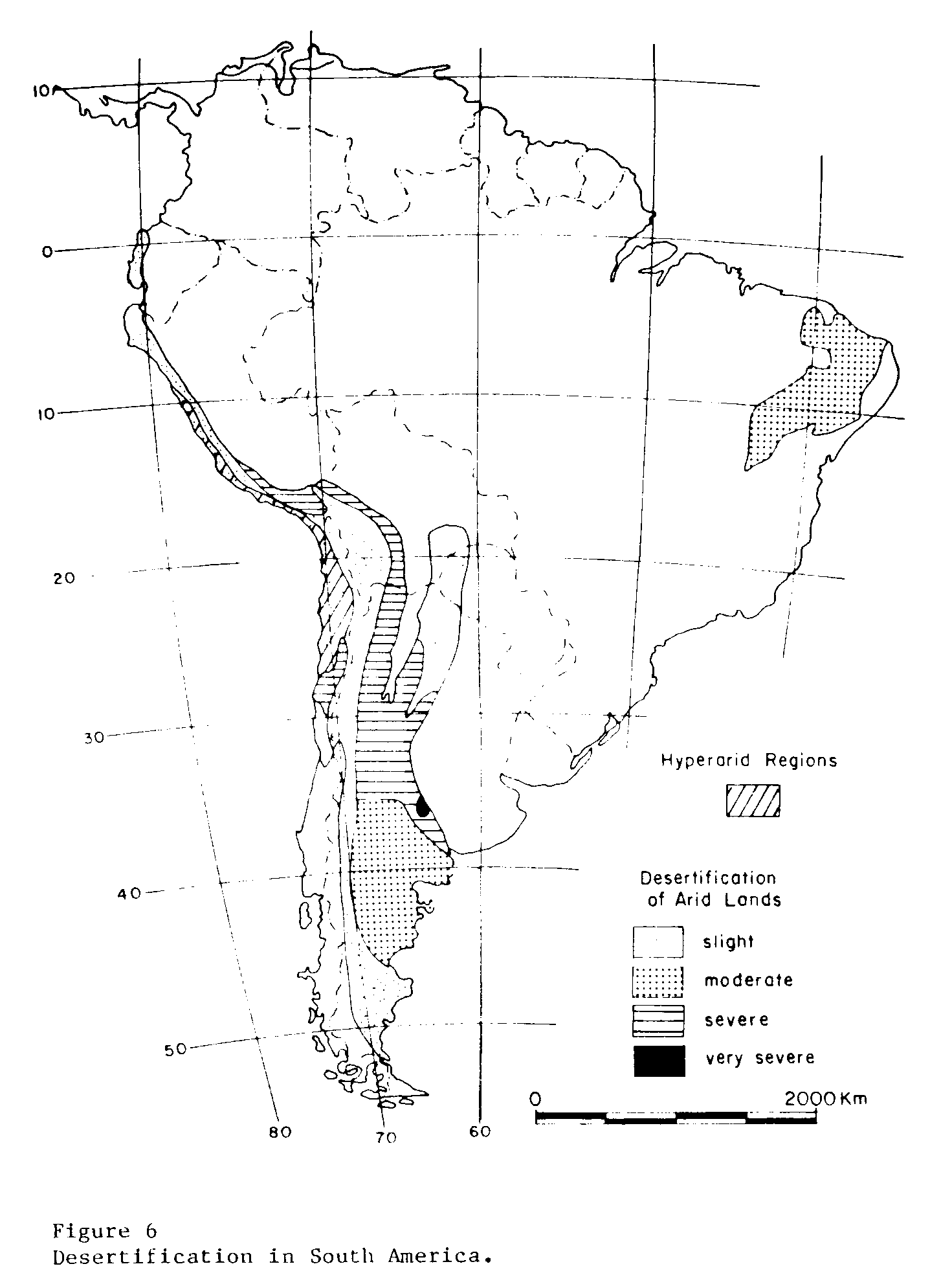
SOUTH AMERICA
Overgrazing, cultivation of unsuitable land, land degradation by woodcutting--and the associated water erosion--are long-standing problems in the arid regions of South America. Wind erosion is a major threat in the semiarid pampas in Argentina, where moving sand dunes have ruined much land. Salinity and waterlogging have adversely affected irrigated regions in western Argentina, particularly along the Rio Salado, and in the numerous narrow irrigated valleys crossing the coastal plain of Peru. The very large salinas and salarea (salt lakes) found in western Argentina, northern Chile, and the altiplano of Bolivia and Chile are of natural origin rather than being due to man's activities. There is little evidence of land improvement, and conditions are either worsening, or at least not improving, nearly everywhere.
Desertification Characteristics
Heavy woodcutting for mine timbers and fuel accompanied the settling of western South America by the Spaniards in the 16th and 17th centuries. Along with that went localized overgrazing of livestock and the cultivation of the nearby slopes, with the inevitable accelerated erosion, It was not until the 19th and 20th centuries, however, that land degradation on the slopes of the Andes Mountains and the coastal ranges become widespread. Population increases and land tenure systems in effect in most countries of South America have combined to put further pressure on the arid regions in recent years (Figure 6).
Desertification has been held to a moderate level in semiarid northeastern Brazil by the erratic character of the rainfall there. Land destruction probably would have been much worse if the rainfall were more reliable and if severe droughts did not occur so frequently. The original caatinga vegetation is xerophytic and is adapted to the long dry periods that occur each year (Banco do Nordeste do Brasil, 1964).
The coast of Peru is crossed by a large number of short rivers flowing from the Andes to the Pacific Ocean. Many of the irrigated valleys are affected to some degree by salinization and waterlogging. The valleys constitute only a small part of the coast desert of Peru and even less of the Chilean desert. Most of the desert has experienced little development or desertification.
Farther south, in the semiarid coastal mountains of Chile, land degradation due to overgrazing and cultivation of sloping lands has been severe around population centers. Indiscriminate woodcutting has also been an important negative factor in the development of the region.
In Argentina, which has more arid land than any other South American country, overgrazing has led to the degradation of range vegetation from the high plateaus in the north to the cold Patagonian desert in the south. Wind erosion plagues both range and cultivated lands, especially in the southern half of the nation.
Magnitude of Desertification
Overgrazing of rangelands has been the most destructive aspect of desertification in all the arid regions of South America. There has been a progressive elimination of palatable species by cattle, sheep, and goats over many decades. Along with this has gone the cutting of trees for timber, firewood, and charcoal. In the Gran Chaco of Argentina it is difficult to find good stands of the valuable red and white quebracho trees that once grew everywhere.
Water erosion has followed overgrazing through the continent, and wind erosion has become an acute problem in parts of Argentina (Prego et al., 1971). The most serious wind damage has been done in the dry-farmed areas of central Argentina where cultivation has led to the formation of mobile dunes. In 1963 an estimated 16,000,000 hectares of land were affected to varying degrees by wind erosion, and the situation has become worse since then. Soil fertility has declined and runoff has increased.
Salinization and waterlogging affect about 20 percent of the irrigated land in the coastal valley of Peru (Comite Peruano de Zonas Aridas, 1963) and large sections of the semiarid Gran Chaco, in and around the province of Santiago del Estero. The same problem, to a lesser degree, appears in the irrigated regions in arid western Argentina and in northeastern Brazil.
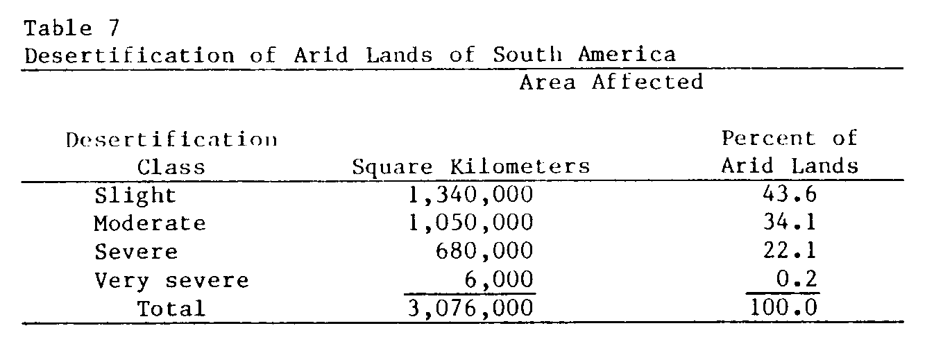
Although only about 22 percent of the arid regions of South America are severely or very severely affected by desertification (Table 7), the problem is critical because the best lands have been degraded and the degradation is continuing. Virtually no improvement of grazing lands has occurred anywhere, nor have soil salinization and water-logging been controlled. Some progress has been made in stabilizing sand dunes in the dry farming areas of Argentina but much remains to be done. Water erosion in the Andes and the semiarid western coastal ranges continues to present problems and may be getting worse. A fast-growing population virtually assures greater desertification in the years ahead unless governments become determined to cope with the problem.
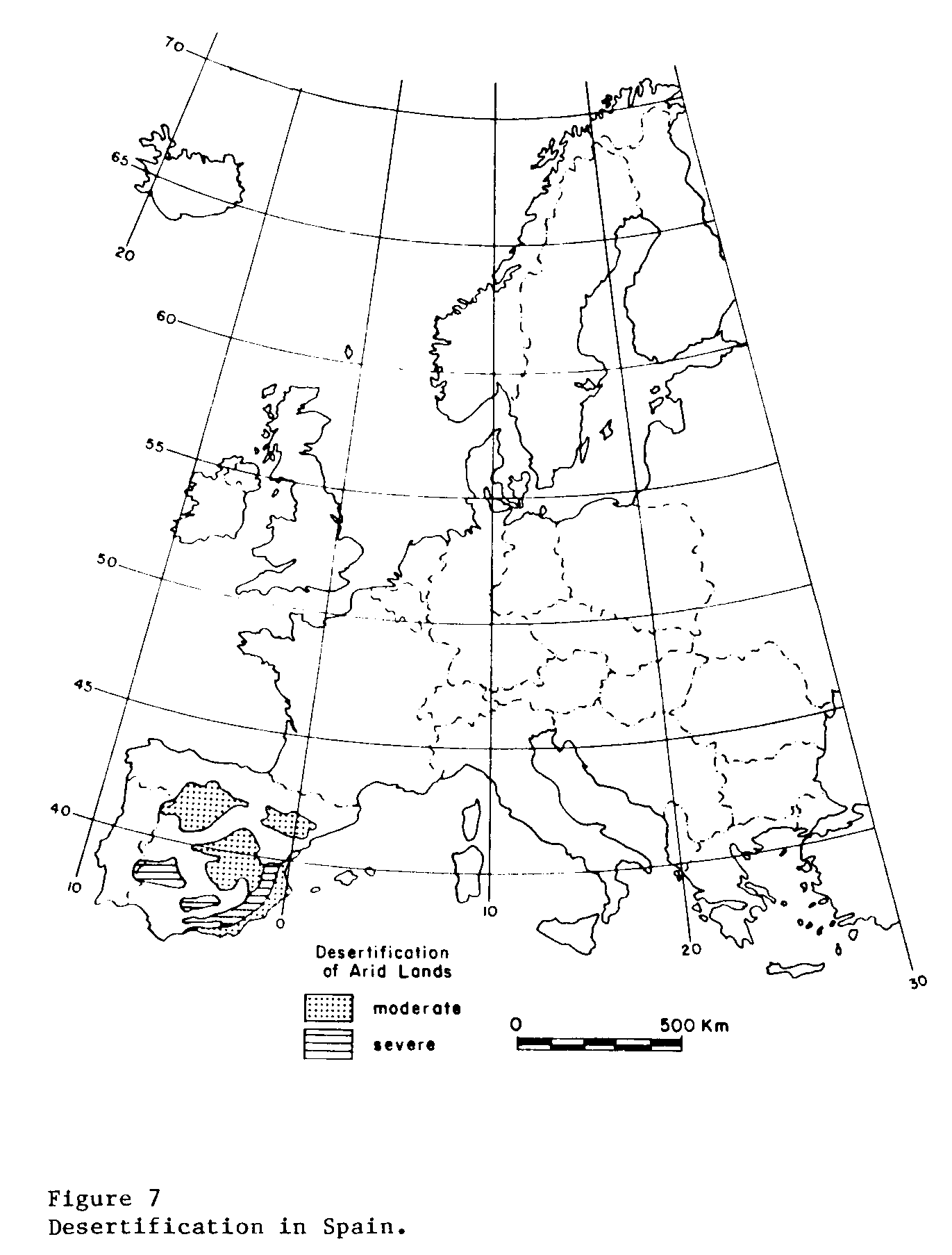
SPAIN
All of the arid regions of Spain have been moderately to severely desertified for decades, if not for centuries (Figure 7). Most of the damage has been done by heavy grazing and woodcutting, but wind and water erosion on cultivated land has also been extensive. Salinization and waterlogging of irrigated land is a major problem in parts of the Ebro River watershed in northeastern Spain. Destruction of the native vegetation and the subsequent water erosion of thin soils on slopes has had a devastating effect on the plant environment and on the potential productivity of the land. Mobile sand dunes are found along the Mediterranean coast.
Desertification Characteristics
During the past several centuries, heavy grazing by sheep and goats has led to the destruction of much of the herbaceous and woody vegetation on the noncultivated land (Albareda, 1955). Water erosion has been severe on the overgrazed slopes as a result of the loss of vegetative cover and the torrential character of the rains. Cutting of wood for fuel and construction and the extension of dryland farming into the pasture lands has accompanied overgrazing. Plant cover has changed to a more xeric type and surface runoff has increased.
A monoculture of grain in the cultivated regions has depleted the native fertility of the soil and has been responsible for increasing the susceptibility of the land to wind and water erosion. Extended droughts from time to time have served to accelerate desertification. Water erosion is severe nearly everywhere on sloping land.
Salinization and waterlogging do not affect a high percentage of the total cultivated land in Spain but important and large areas of affected soils do occur in irrigated valleys. The major salt-affected areas in the northeast are in the Ebro River watershed in the vicinity of Zaragosa and Herida. Seepage water from irrigation on the higher land has caused waterlogging and salinization of lower-lying areas (Martinez, 1978). Gypsum is a common constituent of the soils.
The other major salt-affected areas are in southwest Spain near the coast. The soils are composed of fine-textured sediments that were subjected regularly to flooding by seawater in the past. Surface and internal drainage of the irrigated land is poor and water tables generally are close to the surface. Pumping is required to lower the water tables (Ayers et al., 1960).
Magnitude of Desertification
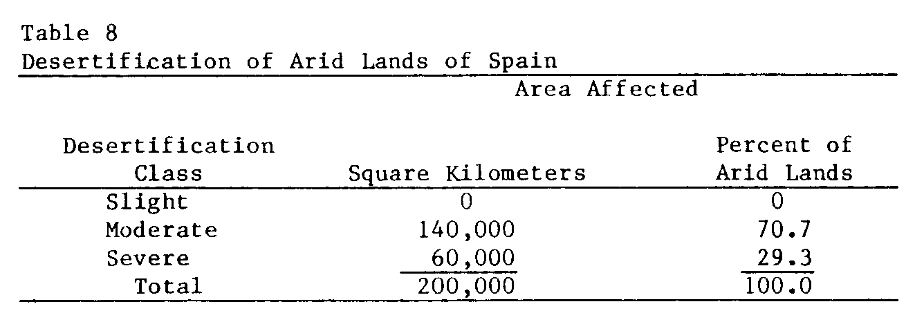
Approximately 50 percent of Spain is arid. In the arid regions about 70 percent is moderately desertified and 30 percent is severely desertified (Table 8).
Virtually all of the rangeland has suffered severe land degradation. Range productivity is probably stabilized at a low level now, with little improvement anywhere. Erosion continues on the extensive dryfarm lands except in a few places where soil and water conservation measures have been instituted. Soil fertility remains low.
Salinization and waterlogging affect about 240,000 hectares of irrigated land to various degrees (Ayers et al., 1960). Reclamation has been undertaken in several areas. Because of the need for more agricultural production and the gradual worsening of the salt problem, irrigation has received special attention in recent decades. Much remains to be done.
Soil and water conservation techniques for dryland farming are known but their application to the field is limited. Range management is not a well-supported science in Spain. Considerable progress has been made in the reclamation of saline soils and procedures for doing so are quite well-known (Martinez, 1978).
REFERENCES
Aboukhaled, A., Arar, A., Balba. A.M., Bishay, B.G., Kadry, L.T. Rijtema, P.E., and Taher, A. (1975) Research on Crop Water Use, Salt Affected Soils and Drainage in the Arab Republic of Egypt. Near East Regional Office, FAO, Cairo, 92 p.
Albareda, J.M. (1955) Influence des changements de la vegetation dans les sols arides. In: Plant Ecology, Arid Zone Research v, UNESCO, Paris, p. 84-88.
Aubreville, A. (1949) Climats, Forest, et Desertification de l'Afrique Tropicale. Societe de Editions Geographiques, Maritime et Coloniales, Paris, 255 p.
Ayers, A.D., Vasquez, A., de la Rublia, J., Blasco, F., and Samplon S. (1960) Saline and Sodic Soils of Spain. Soil Science, v. 90, p. 133-138.
Banco do Nordeste do Brasil (1964) O Nordeste e as Lavouras Xerofilas. Banco do Nordeste do Brasil, S.A., Departmento de Estudos Economicos do Nordeste, Fortaleza, Ceara, 238 p.
Boggess, W., McGrann, J., Boehlje, M., and Heady, E.O. (1979) Farm Level Impacts of Alternative Soil Loss Control Practices. Jour. Soil and Water Conservation, v. 34, p. 177-183.
Cloudsley-Thompson, J.L. (1974) The Expanding Sahara. Environmental Conservation, 1: 5-13.
Comite Peruano de Zonas Aridas (1963) Informe Nacional sobre las Zonas Aridas. Republica del Peru, Ministerio de Agricultura, Lima, 105 p.
Condon, R.W. (1978) Land Tenure and Desertification in Australia's Arid Lands. Search, v. 9, p. 261-264.
Cooke, R.H. and Reeves, R.W. (1976) Arroyos and Environmental Change in the American Southwest. Clarendon Press, Oxford, England, 213 p.
de Crespigny, R.R.C. (1971) China. St. Martin's Press, New York, N.Y., 235 p.
Dahl, G. and Hjort, A. (1979) Pastoral Change and the Role of Drought. Swedish Agency for Research Cooperation with Developing Countries Report R2: 1979, Stockholm, Sweden, 50 p.
Delwaulle, J.C. (1973) Desertification de l'Afrique au sud du Sahara. Bois et Forets des Tropiques, v. 149, p. 3-20.
Delwaulle, J.C. (1977) La situation forestiere dans le Sahel. Bois et Forests des Tropiques, v. 173, p. 3-22.
Dougrameji, J.S. and Clor, M.A. (1977) Case Study on Desertification. Greater Mussayeb Project. Iraq. United Nations Conference on Desertification A/CONF., 74/10, 102 p.
Dregne, H.E. (in press) Historical Perspective of Accelerated Erosion and Effort on World Cultivation. American Society of Agronomy, Madison, Wisconsin.
General Accounting Office (1977) To Protect Tomorrow's Food Supply Soil Conservation Needs Priority Attention. Report to the Congress, CED-77-30, Washington, D.C., 59 p.
Jacobsen, T. and Adams, R.M. (1958) Salt and silt in Ancient Mesopotamian agriculture. Science, v. 128, p. 1251-1258.
Mabbutt, J.A. (1978) Desertification in Australia. Water Research Foundation of Australia Report No. 54, Kingsford, N.S.W., Australia 132 p.
Matrinez Beltran, J. (1978) Drainage and Reclamation of Salt Affected Soils in the Bardenas area, Spain. International Institute for Land Reclamation and Improvement Publication No. 24, Wageningen, The Netherlands, 321 p.
Matheson, W.E. (1978) Soil Loss Made South Australia Come Down to Earth. Journal of Soil Conservation Service of N.S.W., v. 34, p. 88-100.
Newman, J.C. and Condon, R.W. (1969) Land Use and Present Condition. In: R.O. Slayter and R.A. Perry (Editors), Arid Lands of Australia, Australian National University Press, Canberra, Australia, p. 105-132.
Northcote, K.H. and Skene, J.K.M. (1972) Australian Soils with Saline and Sodic Properties. C.S.I.R.O. Soil Publication No. 27, Melbourne, Australia, 62 p.
Office of Environmental Planning and Coordination (1977) Country Report: India. Department of Science and Technology, Government of India, New Delhi, 71 p.
Pearse, C.K. (1971) Grazing in the Middle East: Past, Present, and Future. Journal of Range Management, v. 24, p. 13-16.
Pels, S. (1978) Waterlogging and Salinization in Irrigated Semi-arid Regions of NSW. Search, v. 9, p. 273-276.
Prego, A.J., Ruggiero, R.A., Alberti, F.R., and Prohaska, F.J. (1971) Stabilization of Sand Dunes in the Semiarid Argentine Pampas. In: William J. McGinnies, Bram J. Goldman, and Patricia Paylore (Editors), Food, Fiber and the Arid Lands, University of Arizona Press, Tucson, p. 369-392.
Rapp, Anders (1974) A review of Desertification in Africa-- Water, Report No. 1, Stockholm, Sweden, 77 p.
Soil Research Laboratory Staff (1949) Soil Moisture, Wind Erosion and Fertility of Some Canadian Prairie Soils. Department of Agriculture Publication 819, Ottawa, Canada, 78 p.
Stebbing, E.P. (1937a) The Encroaching Sahara: The Threat to the West African Colonies. The Geographical Journal, 86: 506-519.
Stebbing, E.P. (1937b) The Threat of the Sahara. Journal of the Royal African Society. Extra Supplement to vol. 36, 35 p., May 25, 1937.
Stebbing, E.P. (1938) The Advance of the Desert. The Geographical Journal 91: 356-359.
UNESCO (1977) World Distribution of Arid Regions. Map Scale: 1/25,000,000, UNESCO, Paris.
United Nations (1978) United Nations Conference on Desertification. Round-up, Plan of Action, and Resolutions, United Nations, New York, 43 p.
Vander Pluym, H.S.A. (1978) Extent, Causes and Control of Dryland Saline Seepage in the Northern Great Plains Region of North America. In: H.S.A. Vander Pluym (Editor), Dryland-Saline-Seep Control, Agriculture Center, Lethbridge, Alberta, v. 1, p. 48-58.
Wagner, R. (1978) Soil Conservation in New South Wales, 1938-1978. Journal Soil Conservation Service of N.S.W., v. 34, p. 124-132.
Weaver, J.E., and Albertson, F.W. (1940) Deterioration of Midwestern Ranges. Ecology, v. 21, p. 216-236.
Widstrand, C.G. (1975) The Rationale of Nomad Economy. Ambio, v. 4, p. 146-153.