 Reproduced, with permission, from:
U.S. Department of Agriculture, Soil Conservation Service. 1977. Some serious erosion areas in the United States. Forth Worth, TX: South National Technical Center. Unpublished technical notes.
Reproduced, with permission, from:
U.S. Department of Agriculture, Soil Conservation Service. 1977. Some serious erosion areas in the United States. Forth Worth, TX: South National Technical Center. Unpublished technical notes.
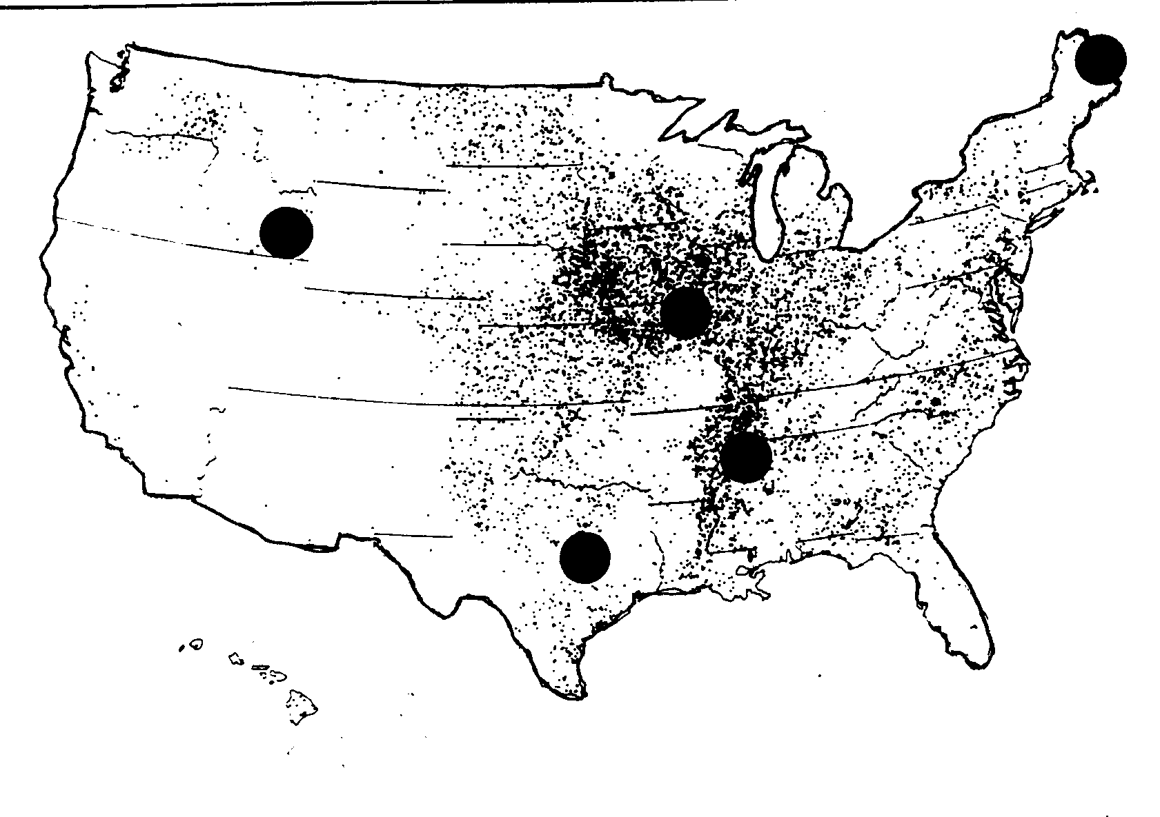
The colored areas on the map below, which show total tons of sheet and rill erosion on cropland, indicate several of the more serious erosion areas in the country.
Cropland Sheet and Rill Erosion: 1977
Total for United States is 2,000,000,000Data for Alaska not available
1 dot = 250,000 tons
* The Palouse, covering parts of Washington, Oregon, and Idaho, is dryfarmed to wheat, barley, peas, and lentils. Most of the cropland is hilly, with slopes of from 15-25 percent. Runoff from melting snow and heavy rains cause erosion of 50 to 100 tons per acre.
* Southeastern Idaho cropland is planted in hard red wheat one year and left fallow the next to conserve moisture. Erosion occurs during intense summer rainstorms and even more destructive rains in late winter, when a thawed layer of soil moves downhill over frozen subsoil. Annual erosion may reach 16 tons per acre per year on 35 percent slopes.
* Texas Blackland Prairie is an important farming area, with two-thirds of the land in crops, mainly cotton and grain sorghum. Rainfall averages 30 to 50 inches a year on the gently rolling land. Many soils in the area are highly erodible, and erosion is appreciably higher than the national average.
* Southern Mississippi Valley, including parts of five states, is about one-third cropland, much of it sloping to steep. The soils are deep, fertile, productive, and erodible. Many row crops are grown without adequate conservation practices, and annual soil losses on much of the land reach 20 tons per acre or
* The Corn Belt States experience some of the highest erosion rates in the country: in 1977, Iowa cropland lost an average of 9.9 tons of soil per acre; Illinois, 6.7 tons per acre, and Missouri, 10 9 tons per acre.
* Aroostook County, Maine, is famous for its potatoes. They are grown on slopes ranging from nearly level to 25 percent. The upper 2 feet of soil have been lost since cultivation began, lowering crop yields. Some sloping fields are losing as much as an inch of soil a year.