 Reproduced, with permission, from:
Zhu, Z., and T. Wang. 1993. Trends in desertification and its rehabilitation in China. Desertification Control Bulletin 22: 27-30.
Reproduced, with permission, from:
Zhu, Z., and T. Wang. 1993. Trends in desertification and its rehabilitation in China. Desertification Control Bulletin 22: 27-30.
By Zhu Zhenda
Director and Professor
International Centre for Research and Education on Desertification ControlInstitute of Desert Research
Chinese Academy of Sciences
Lanzhou, China
Desertification is an important ecological problem in the world today. Judging by the situation in China we consider that desertification is a process of environmental degradation under fragile ecological conditions and intensive human activities. This process of degradation leads to the occurrence of a desert-like landscape and a reduction in land productivity.
In the arid and semi arid regions of north China the main aspect of degradation is sandy desertification (including shifting sand dunes, sand dune reactivation, shifting sands spreading into grasslands and wind erosion in dry farmland). It covers about 334,000 km[2] of which 197,000 km[2] has already been desertified and 137,000 km[2] is being threatened by its process. A population of about 35 million people is affected. By comparing and interpreting aerial photographs taken at the end of the 1950s and the middle of the 1970s, we note that the sandy desertified land has increased from the previous 137,000 km[2] to 176,000 km[2]. In other words, 39,000 km[2] of sandy land was desertified during this 25 year period, an average annual loss of 1,560 km[2].
From 1975-1987, judging by aerial photographs, TM imagery analysis and field investigation, we note that the sandy desertified lands have increased by 25,200 km[2], an average of 2,100 km[2] annually. In north China. the sandy desertified lands are mainly distributed in:
(a) agropastoral regions in the semi arid zone - about 40.5% of total sandy desertified land;(b) undulating desert steppe in the semi arid zone - about 36.5%;
(c) marginal oases and lower reaches of inland river in the arid zone - about 23%.
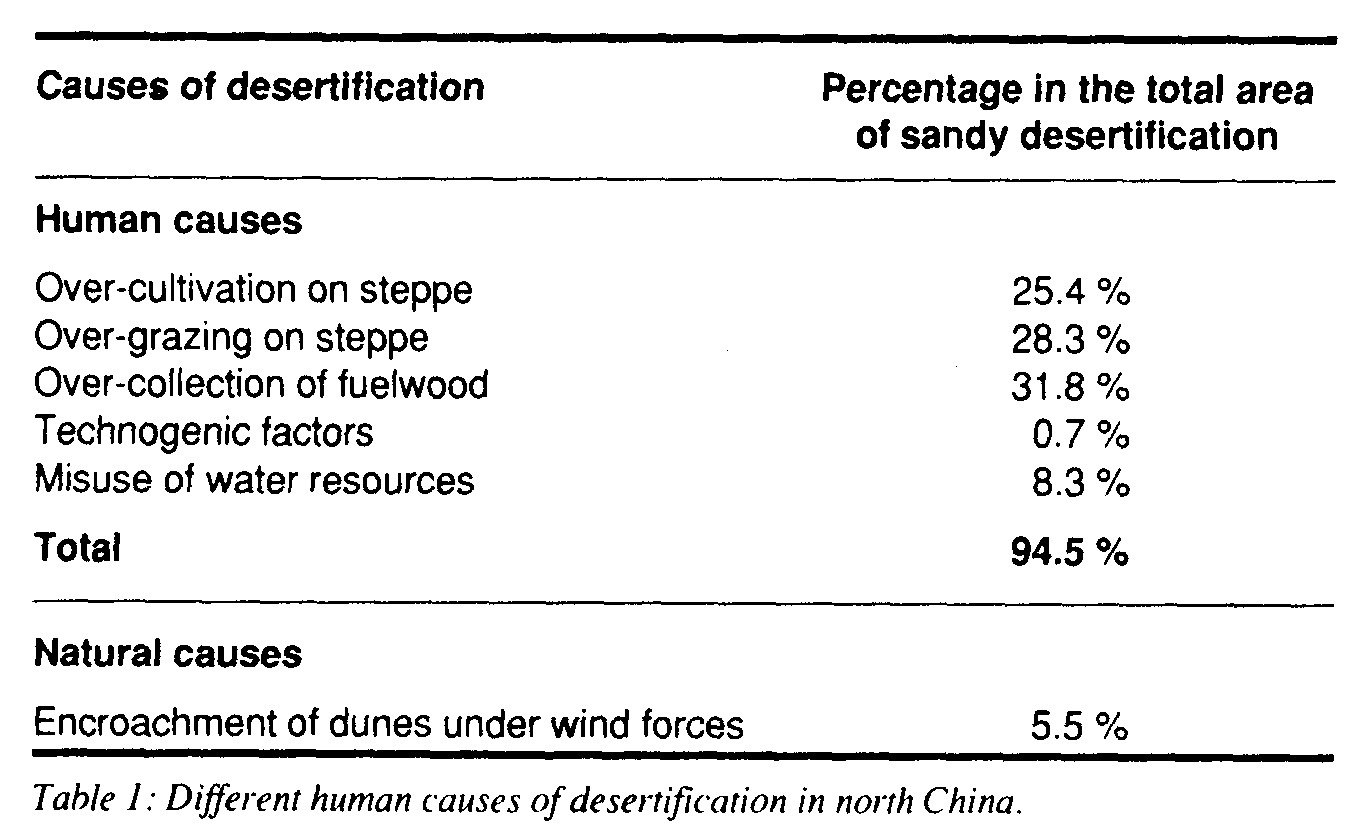
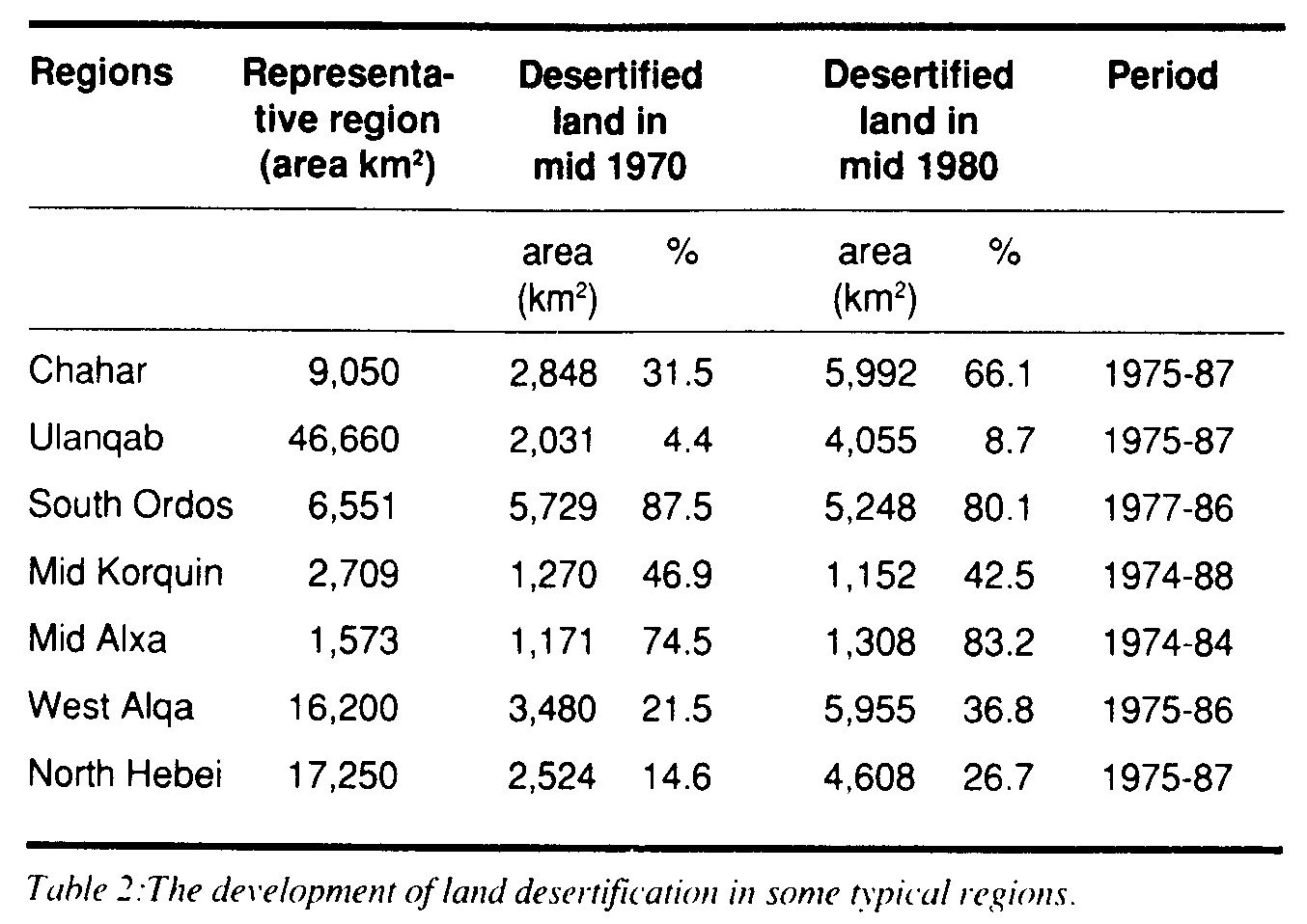
Table 1 shows the different human economic activities that cause the sandy desertification. Table 2 shows the development of desertified land in some typical regions in north China during the 1970s and 1980s.
From the view point of spatial distribution of desertification in the last 10 years, the following points are worth mentioning:
1 The dry farmlands in the sandy steppe region represent territories prone to desertification or land with high rates of ongoing desertification (Table 3). In the last 10 years the desertification of grassland has developed at an amazing velocity with the annual spread rate of desertified land reaching 5-10%.2 In some pre-existing desertified regions such as sandy land in Horqin and along the great wall in Shaanxi province, recent development and the adoption of some control measures has reduced the rate of desertification. The annual spread rate varies between 2-5%.
3 In recent years, with the construction of the energy base, in particular open coal mining, the desertified lands have spread rapidly. For example, the area of desertified land in Shenfu coal field is now some 62%.
4 In the last 10 years, desertification of grasslands has also developed very quickly (Table 4). For example, in the north pan of Ulanqab league the desertified land area has increased from 18.1% in the 1970s to 30.4% in the 1980s. It is characterized by the ground surface becoming rough, the appearance of shifting sand and the deterioration in quality of the grasslands.
5 When some control measures have been adopted over 10 years, the spatial range of desertified land has contracted. In the southeast part of sandy land in Mu Us, reversion was at an annual rate of between -0.6% to -0.8%.
6 In desertified regions with "ecological elasticity" in the semi-arid zone, desertified land can be rehabilitated in 5-7 years as long as some measures are adopted, including readjustment of the land use structure, fencing to exclude grazing animals, and afforestation and stabilization of shifting sand dunes. This can be seen, in particular, in the Huihe region of Hulun Buir steppe where the natural condition is better than other sandy areas. The desertified land has been transformed into woodland of Pinus sylvestris.
The development trend of desertification according to three landuse types in north China in recent years is summed up in Figure 2. From this analysis we can conclude that although the desertified area of some localities has been reduced since 1975, as a whole, desertification is still a spreading trend. In the rehabilitation of desertified land, protection should first be given to threatened productive desertified land, otherwise desertification will be exacerbated and will result in great economic loss.
In recent times desertification in subhumid and humid regions has also become an important ecological/environment problem. For example, the blown-sand lands dotted in the coastal region and north China plain cover 37,000 km[2]. Hot dry valleys in southwest China, such as the valleys of the Jinshajiang River and Minjiang River have developed sand dunes along their length. In the low reaches of Ganjiang River close to the city of Nanchang and on the banks of Poyang Lake in Jiangxi province, blown-sand lands cover an area of 3.2 x 10[4]ha.
Desertification caused by water erosion is also very severe. In the hilly region of granite red rock series and laterite in southeast China, the desertified area measures 0.197 million km[2]. In the mountain and hilly region in southwest China the desertified area is O.457 million km[2]. Therefore it is very important to find different ways to bring the different types of desertification under control.
Studies of the characteristics, development processes and trends of desertification, and practices to combat the problem have been carried out in different natural zones, namely at:
1 Linze station at an oasis in the margin of an arid desert zone;2 Shapotou station in a sandy desert region in an arid zone;
3 Yanchi station in a desert-steppe zone;
4 Naiman station in a semi-arid zone;
5 Yuchen station in a sub-humid zone; and
6 Nanchang station in a sub-tropical humid zone.
On the basis of this work, and over many years, we have developed a model for rehabilitation of desertified land which combines experimental, demonstration and popularization processes. The model is composed of three systems:
1 The target of rehabilitation is for complete desertification control and improvement of the economic development system. This includes the following:
(a) economizing in the use of resources;(b) moderate exploitation;
(c) environmental protection.
2 Measures should be suited to local conditions. For example, with regard to desertification in wind erosion zones in:
(a) Arid Regions
Water resources should be reasonably distributed from upper to lower reaches of the inland river and water-economizing agricultural practices should be developed. Protective networks should be established in oases and windbreaks of trees and shrubs should be set up around the oases. Plants should be grown and mechanical fences to control movement of sand should be set up to stabilize shifting sands outside the oases.(b) Semi-arid Regions
The structure of landuse in drylands should be readjusted and the carrying capacity should not be overtaxed by grazing. The forest and grassland area should be enlarged and those lands with better water and soil conditions should be used for intensive farming and be provided with shelterbelts. The planting of forest between dunes should be combined with the fencing of rangeland and forage farming should be carried out.(c) Humid and Sub-humid Regions
Sandy land should be flattened and irrigation systems set up. Sandy land should then be covered with clay and forests or grass should be planted. The construction of wind break forests should be combined with the planting of fruit trees or another economic crop.3 These measures are implemented through:
(a) High-level policy-making and the involvement of leading organizations at different levels.(b) The provision of technical advice to landusers from research institutes and science and technology departments.
(c) Cooperation with research institutes, local governments and local people.
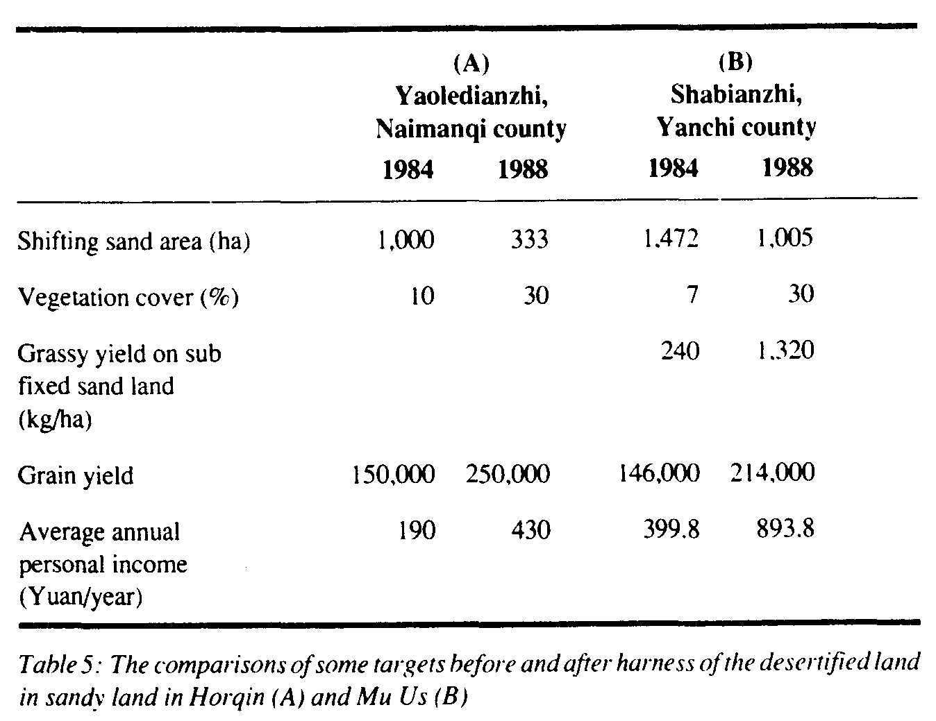
This model tallies with the actual situation of different desertified regions and also achieves the goal of integrating the ecological economic and social benefits together. Two examples of where the model has been successfully applied are shown in table 5. Another example in southern China is the Tangbeihe River basin of Xingguo county where severely desertified land caused by water erosion covered 82.4% of the whole basin. After 10 years of rehabilitation the vegetative cover has increased from 10% to 53%, the total grain yield increased by 32% and average personal income increased 7 times.
These examples prove that land desertification can be checked and that desertified land can be turned into productive agropastoral land so long as the necessary measures are adopted.
UNEP, 1991. Status of Desertification and Implementation of the United Nations Plan of Action to Combat Desertification, Nairobi, Kenya.
Zhu Zhenda, Liu Shu, 1981. Processes and control of desertification (in Chinese), Chinese Forest Press Beijing, China.
Zhu Zhenda, Liu Shu, 1989. Desertification and its control in China (in Chinese), Science Press, Beijing, China.
Zhu Zhenda, Wang Tao. 1990. An analysis of the trend of land desertification in Northern China during the last decade based on examples from some typical areas (in Chinese), ActaGeogr.Sin., 45, Science Press, Beijing, China.