 Reproduced, with permission, from:
Singh, G., R. Babu, P. Narain, L. S. Bhushan, and I. P. Abrol. 1992. Soil erosion rates in India. Journal of Soil and Water Conservation 47 (1): 97-99.
Reproduced, with permission, from:
Singh, G., R. Babu, P. Narain, L. S. Bhushan, and I. P. Abrol. 1992. Soil erosion rates in India. Journal of Soil and Water Conservation 47 (1): 97-99.
ABSTRACT: Because land degradation from water-induced soil erosion is a serious problem in India and only fragmentary information on factors affecting soil erosion is available, an attempt was made to prepare a countrywide map of soil erosion rates for land use planning. To prepare the map, available maps of soil, rainfall erosivity, slope, land use, forest vegetation, degraded land, sand dunes, and irrigation were used. Soil loss data from various research stations, watersheds, and sedimentation of reservoirs also were used. Soil losses for a number of places were estimated using the universal soil loss equation. Based on these 21 observed and 64 estimated soil loss data points spread over different land resource regions of the country and superimposing eight above-mentioned maps, iso-erosion rate lines were drawn. Annual erosion rate due to water is less than 5 Mg/ha/yr (2.2 tons/acre) for dense forest (above 40% canopy), cold desert regions, and arid regions of India. Wind erosion is also active in the Indian desert situated in the northwestern part of the country. Indo-Gangetic plains, including salt-affected lands, of Punjab, Haryana, Uttar Pradesh, Bihar, and West Bengal show moderate erosion rates (5-10 Mg/ha/yr). The areas revealing severe erosion---more than 20 Mg/ha/yr---include the Shiwalik Hills, northwestern Himalayan regions, ravines, shifting cultivation regions, Western Coastal Ghats and the black cotton soils areas of Peninsular India. Remaining parts of the country lose between 10-20 Mg/ha/yr. The map is a first approximation of soil erosion rates in India; it can be further refined as more data become available. In spite of limitations, this map will prove to be a handy tool for planners, watershed managers, and policymakers in developing appropriate land use for achieving sustained productivity.
An effort was made nearly a decade ago to estimate soil erosion in India through available information on soil loss from small runoff plots, small and large watersheds, and reservoirs (17), by land resource region (12). Later, soil erosion rates in large catchments were predicted using erosion prediction models (6, 18). These computations showed off-site deposition of sediment in reservoirs, but not the true on-site erosion rates, which include displacement and deposition of sediments within the catchment. More dependable soil erosion rates are required for land use planning and extension of soil water conservation works in the country.
Soil erosion is a complex phenomenon governed by a large number of factors, such as rainfall erosivity, soil erodibility, slope, land use, and conservation measures. There exists an iso-erodent map of India, based on distribution of erosion index values (18), that shows potential erosivity of rainfall. There also exists an erosion map prepared in the 1970s and later modified (1, 4). This map shows only the extent of various types of erosion in a generalized way.
The quantification of soil erosion is an expression of soil erosion rates, which is given in units of mass or volume per unit area per unit time. There is an urgent need, and this is an attempt, to prepare a first approximation map of soil erosion rates of India. The map is based on available information about soil types; rainfall erosivity potential; slope; land use; forest vegetation; and erosion rates of small, medium, and large reservoirs and catchments. Soil erosion rates of ravines, shifting cultivation, Shiwaliks, and snowclad cold desert also were considered in preparing the map. In India, Shiwaliks are northwestern foothills of the Himalayas in the states of Jammu and Kashmir, Punjab, Himachal Pradesh, Haryana, and Uttar Pradesh. They are comprised of sandstone, grit, and conglomerates, with characters of fluvial deposits with deep soils, but slopes near the foothills contain pebbles and boulders. These formations are geologically weak, unstable, and highly prone to erosion .
Scanty information is available on soil erosion rates in India. Existing data were used. These data sources were complemented by estimates of soil loss using the universal soil loss equation (USLE). The soil erosion map was prepared using eight different maps at 1:6,000,000 scale.
Data sources. Observed soil loss data for different land uses were collected from 21 research stations and watersheds under the Indian Council of Agricultural Research and other organizations in the country's 20 different land resource regions (12). Sedimentation data from small, medium, and large reservoirs (2) were assembled and an irrigation map (3) used to demarcate the catchments of the reservoirs. For cold-desert regions having a low erosivity factor, we adopted a reasonable value of soil loss (20). Information with respect to ravines, shifting cultivation regions, and Shiwaliks generated at the Indian Council of Agricultural Research stations were used for the erosion rates in these problem regions.
Soil loss estimation. Erosion estimates using the USLE were made at 64 stations. The USLE is the best empirical soil loss prediction equation, in spite of its limitations (21). That equation is A=R K L S C P, where A is average annual soil loss, R is the rainfall erosivity factor, K is the soil erodibility factor, L is the slope-length factor, S is the slope steepness factor, C is the cover factor, and P is the conservation supporting-practice factor.
For the rainfall factor, R, we used the 1978 iso-erodent map of India (18). We estimated the soil erodibility factor, K, with the help of a nomograph (21), using data from the 64 soil series (16) mapped on a 1:7,000,000-scale soil map of India (14). The topographic factor, LS, was calculated (21) using a slope map of 1:6,000,000 scale (9). The crop management factor, CP, was estimated using C values from different research stations in the country, along with associated conservation practices, such as contouring, contour bunding, bench terracing, and other practices (13). The map of the agricultural regions of India at a 1:6,000,000 scale (7) and the area under different crops (5) was used in computing the crop management factor.
Map development. All 21 of the observed points and the 64 estimated points were plotted on a 1:6,000,000-scale map of India. Eight, 1:6,000,000-scale maps of soil type, slope, rainfall erosivity, land use, forest vegetation, degraded land, sand dunes, and irrigated land were superimposed. Ravines were delineated using a wasteland map of India (8).
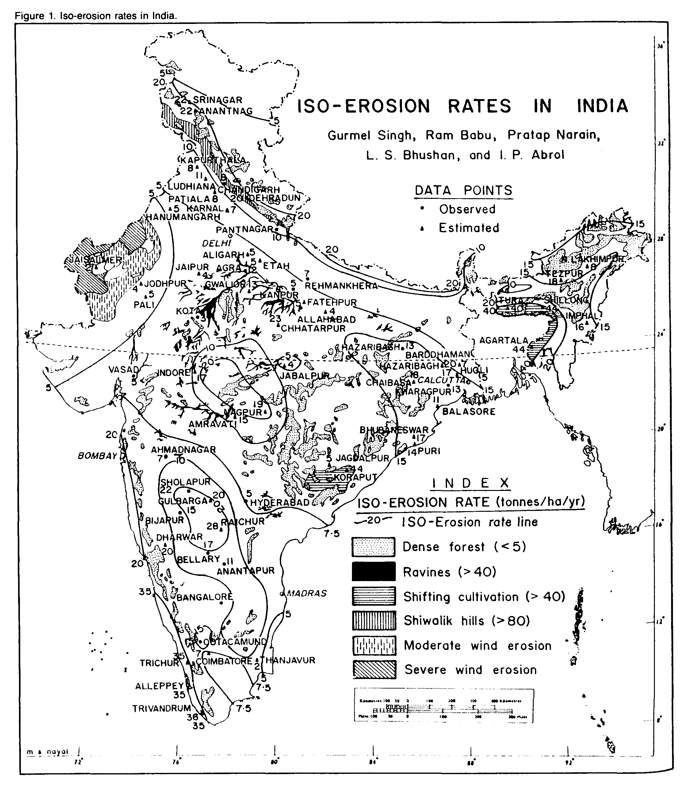
Shiwalik regions reportedly yield a great deal of sediment to Sukhana Lake in Chandigarh (15). This is due to pinacle erosion in this region, although some ranges of Shiwaliks are vegetated too. Pinacle erosion is the result of deep vetrical rills, which leave islands in the bed of a gully, possibly due to an imbalance of excessive sodium and complete deflocculation in these formations. Therefore, an accepted average soil erosion of 80 Mg/ha (35.7 tons/acre) was used for the Shiwalik regions.
In Indian deserts, situated in the northwestern portion of the country and covering about 286,000 km2 (110,500 square miles), wind erosion is also active over 129,000 km[2] (50,000 square miles) (8). The removal and deposition of sand during a 70-day period from April to June may vary from 1,449 to 5,560 Mg/ha (645 to 2,480 tons/acre) (11).
The extent and degree of sand dunes in Rajasthan state was delineated from the Agricultural Atlas of Rajasthan (19). The National Forest Vegetation map (10), prepared by the Forest Survey of India, was superimposed to delineate forest areas. On this map, forests are divided into three classes: dense forest, with crown density greater than 40%, covering 10.9% of the land; open forest, with crown density of 10-40%, covering 8.4% of the land; and nonforest areas, covering 77.8% of total area of the country. In the dense forest area, average annual soil loss ranged from 2 to 3 Mg/ha (0.9 to 1.3 tons/acre); hence, this area was delineated in the less-than-5 Mg/ha (2.2 tons/acre) soil loss category. For open forest, soil loss values varied widely, from 5 to 20 Mg/ha (2.2 to 8.9 tons/acre). Nonforest areas were considered in croplands for which CP values have been calculated separately.
Iso-erosion rate lines were drawn considering all these factors, which resulted in the iso-erosion rate map of India.
The iso-erosion rate map (Figure 1) is a first approximation of water erosion in India. The number identifying each isoerosion rate is the numerical value of erosion rate in Mg/ha/yr along that line. Points lying between the indicated iso-erosion rates can be approximated by linear interpolation. The annual water erosion rate values ranged from less than 5 Mg/ha/yr for dense forest, snowclad cold deserts, and the arid region of western Rajasthan to more than 80 Mg/ha/yr (36 tons/acre) in the Shiwalik hills. Ravines along the banks of the Yamuna, Chambal, Mahi, Tapti, and Krishna Rivers and in the shifting cultivation regions of Orissa and the northeastern states also revealed soil losses exceeding 40 Mg/ha/yr (18 tons/acre). The annual erosion rates in Western Ghats coastal regions varied from 20 to 30 Mg/ha (9 to 13 tons/acre).
Erosion rates in the black soil region (vertisols) of the country, occupying a 64-million-ha (158-million-acre) area in Karnataka. Andhra Pradesh, Madhya Pradesh, and Maharashtra states, generally were 20 Mg/ha/yr. Red soils of Chhotnagpur plateau also recorded a soil loss value of 10 to 15 Mg/ha/yr (4.5 to 7 tons/acre/year). The northwestern hills of Jammu and Kashmir, Himachal Pradesh, and Uttar Pradesh and the northeastern hills of Bengal and the northeastern states contribute more than 20 Mg/ha/yr. Foothills of the Himalayas and the Doon Valley produced 20 Mg/ha/yr of soil loss. Erosion rates on alluvial Indo-Gangetic Plains of Punjab, Haryana, Uttar Pradesh, Bihar and West Bengal are moderate (5-10 Mg/ha/yr). The salt-affected saline and sodic soils of these plains were within limits of 5 Mg/ha/yr.
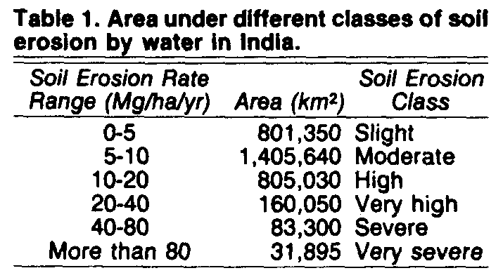
We classified soil erosion rates into six categories (Table 1), based on our personal experience. Table 1 also shows the areas under various erosion classes. These classes ultimately must be based on soil depth and the loss of soil productivity as it relates to erosion.
The map is a first approximation of soil erosion rates in India. It can be further refined as more data become available. In spite of limitations, this map will prove to be a valuable tool for planners, watershed managers, and policymakers who must develop appropriate land uses for achieving sustained productivity.
1. Ahmad, s. 1973. Soil erosion in India. Asia Publ. House Bombay, India.
5. Fertilizer Association of India. 1988-1989. Fertilizer statistics 1988-1989. New Delhi, India.
6. Garde, R. J., and V. C. Kothyari. 1987. Sediment yield estimation. J. Irrig. and Power, 44(3).