 Reproduced, with permission, from:
National Aeronautics and Space Administration (NASA). 1993. Earth Observing System (EOS) Reference Handbook, ed. G. Asrar and D. J. Dokken. Washington, D. C.: National Aeronautics and Space Administration, Earth Science Support Office, Document Resource Facility.
Reproduced, with permission, from:
National Aeronautics and Space Administration (NASA). 1993. Earth Observing System (EOS) Reference Handbook, ed. G. Asrar and D. J. Dokken. Washington, D. C.: National Aeronautics and Space Administration, Earth Science Support Office, Document Resource Facility.
In the next century, planet Earth faces the potential hazard of rapid environmental change, including climate warming, rising sea level, deforestation, desertification, ozone depletion, acid rain, and reduction in biodiversity. Such changes would have a profound impact on all nations, yet many important scientific questions remain unanswered. For example, while most scientists agree that global warming is likely, its magnitude and timing (especially at the regional level) are quite uncertain. Additional information on the rate, causes, and effects of global change is essential to develop the understanding needed to cope with it. The National Aeronautics and Space Administration (NASA) is working with the national and international scientific communities to establish a sound scientific basis for addressing these issues through research efforts coordinated under the U.S. Global change Research Program (USGCRP), the International Geosphere-Biosphere Program (IGBP), and the World Climate Research Program (WCRP).
Scientific research shows that the Earth has changed over time, and continues to change. Human activity has altered the condition of the Earth by reconfiguring the landscape, by changing the composition of the global atmosphere, and by stressing the biosphere in countless ways. There are strong indications that natural change is being accelerated by human intervention. In its quest for improved quality of life, humanity has become a force for change on the planet, building upon, reshaping, and modifying nature--often in unintended ways.
Carbon dioxide, methane, nitrous oxide, and other gases trap heat emitted from the Earth's surface, thus warming the global atmosphere. Measurements over the past several decades have documented a rapid rise in concentrations of these greenhouse gases, but the long-term trend of global temperature is not yet predictable (see Figure 1). Changes in other variables (e.g., global cloudiness, concentration of atmospheric dust particles, ocean circulation patterns) also have an impact on global temperature. The existing space-based systems for global monitoring lack the spatial, temporal, and spectral coverage needed to provide observations of sufficient accuracy and precision to interpret the interactions among these variables, and their individual and combined contributions to global climate. Furthermore, current modeling of these interactive processes is not sufficiently accurate to generate reliable predictions of the magnitude and timing of global climate change.
Only through research can scientists further knowledge of climate change, providing guidance to policymakers who must balance the needs of constituents with the welfare of the planet and the species that inhabit it. The study of ozone levels by the Upper Atmosphere Research Program (UARP) illustrates how Earth science research yields a clear picture of human-induced global change. In the 1970s, scientists first proposed the chemical processes by which human-made chlorofluorocarbons (CFCs) deplete stratospheric ozone. After a long-term research program based on in situ and space-based observations, the international scientific community reached a consensus on global ozone depletion. The evidence and understanding gained from this research led to the Montreal Protocol for worldwide reduction in the production of CFCs in the 1990s.
Mission to Planet Earth (MTPE) is a NASA-initiated concept that uses space- and ground-based measurement systems to provide the scientific basis for understanding global change. NASA's contributions to MTPE include ongoing and near-term satellite missions, new missions under development, planned future missions, management and analysis of satellite and in situ data, and a continuing base research program focused on process studies and modeling. The space-based components of MTPE will provide a constellation of satellites to monitor the Earth from space. Sustained observations will allow researchers to monitor climate variables over time to determine trends; however, space-based monitoring alone is not sufficient. A comprehensive data and information system, a community of scientists performing research with the data acquired, and extensive ground campaigns are all important components. More than any other factor, the commitment to make Earth science data easily available to the research community proves critical to mission success. Brief descriptions of the various elements that comprise the overall mission are provided in the following subsections.
Satellites stationed in a variety of orbits form the space component of MTPE. No single orbit permits the gathering of complete information on Earth processes. For example, the medium-inclination orbit of the recently launched Upper Atmosphere Research Satellite (UARS) was chosen specifically because of the UARP focus on the processes influencing ozone depletion. High-inclination, polar-orbiting satellites are needed to observe phenomena that require relatively detailed observations on a routine basis, often from a constant solar illumination angle. Geostationary satellites are needed to provide continuous monitoring of high temporal resolution processes; an international array of these platforms now provides coverage on a near-global basis. This coverage will be improved early in the next century by geostationary satellites planned by NASA and its international partners. Each NASA flight program includes a dedicated science team, and the data from each will be made available to the global scientific community on a full and open basis.
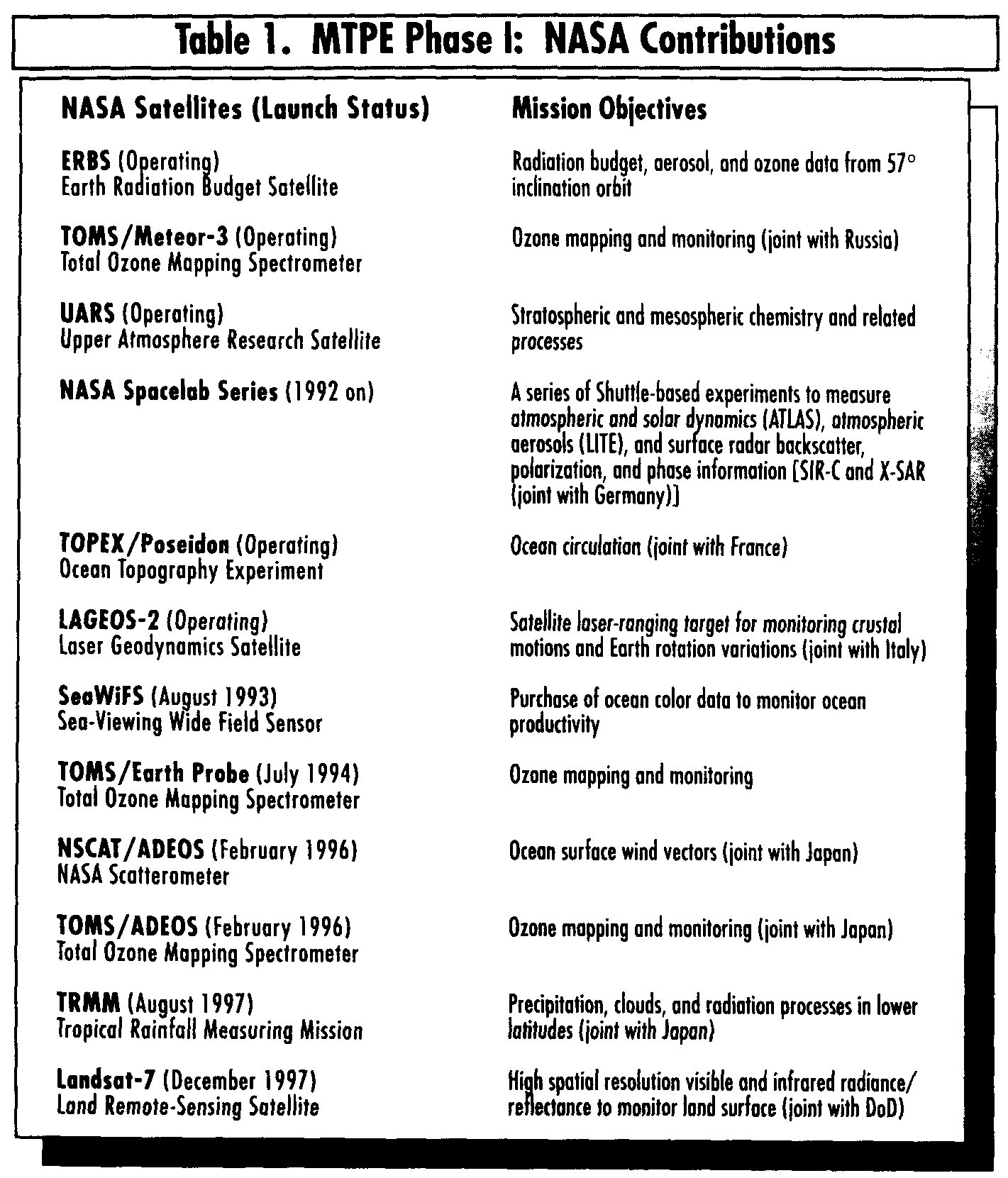
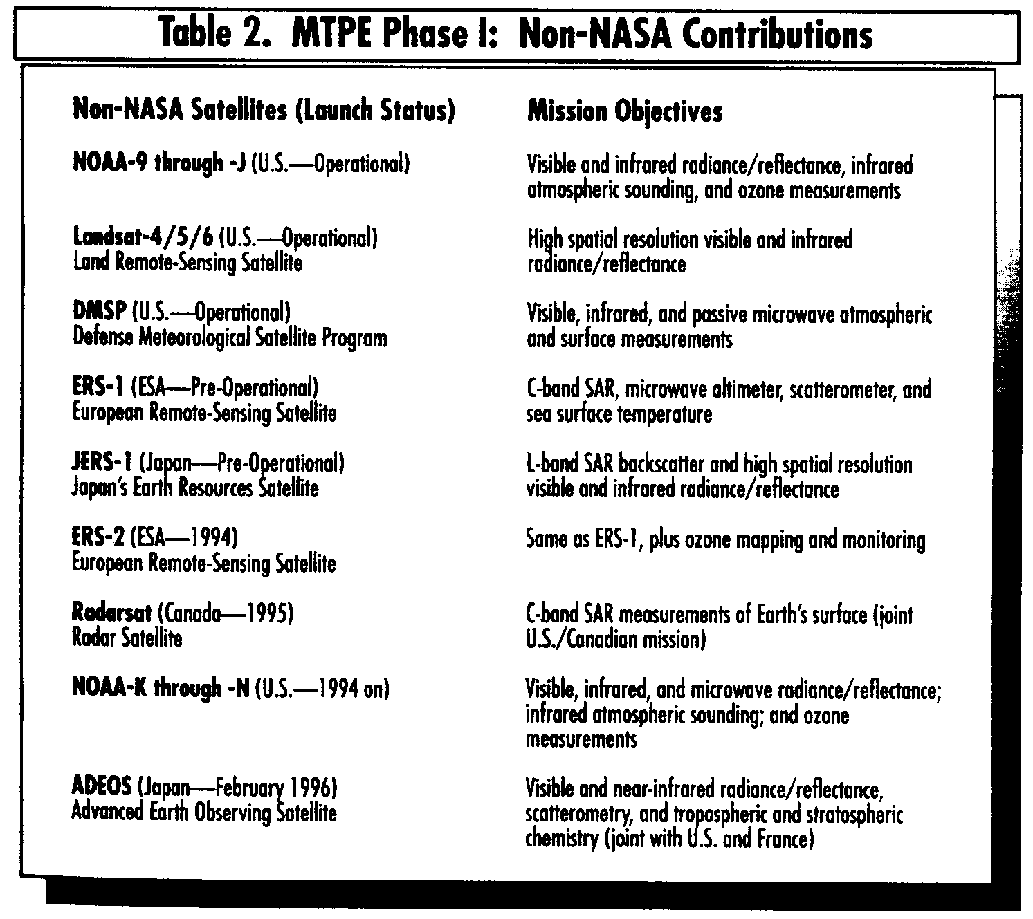
Table 1 delineates NASA's contributions to Phase I of MTPE, and Table 2 identifies the international suite of Earth observations satellites that will be in place during this period.
The Earth Observing System--a series of polar-orbiting and low-inclination satellites for long-term global observations of the land surface, biosphere, solid Earth, atmosphere, and oceans--is the centerpiece of MTPE. In tandem with EOS, the polar-orbiting and mid-inclination platforms from Europe, Japan, and the U.S. National Ocean and Atmospheric Administration (NOAA) form the basis for a comprehensive International Earth Observing System (IEOS). NASA, Japan, and the European Space Agency (ESA) programs will establish an international Earth-observing capability that will operate for at least 15 years. IEOS will allow scientists to obtain information at many levels of detail, covering all major Earth system processes.
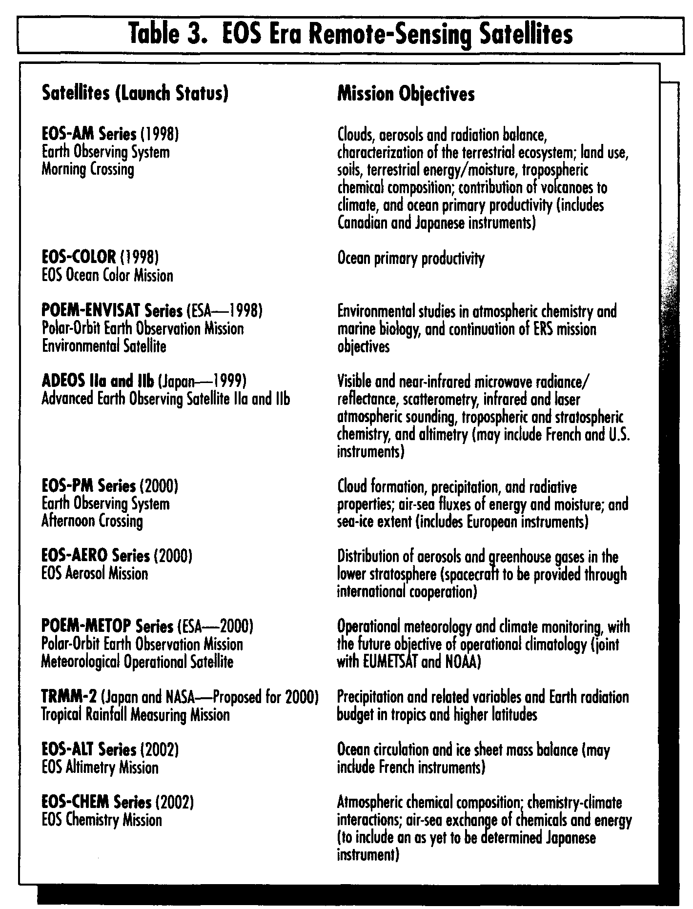
Table 3 identifies the NASA, other U.S., and international contributions of Earth observations satellites during the EOS period. Additional details on these satellites are presented in the Mission Elements section of this Handbook. EOS will carry two classes of instruments: Facility Instruments supplied by NASA in response to general mission requirements, and Principal Investigator (PI) Instruments selected through a competitive process and aimed at the focused research interests of the selected investigators. Of course, the latter are also responsive to overall EOS objectives. The EOS Instruments section provides details on the science to be accomplished and engineering specifications for the 23 instruments remaining as part of the EOS Program (except for the as yet to be determined Japanese instrument to be accommodated on the EOS-CHEM series).
EOS science objectives address the fundamental physical, chemical, and biological phenomena that govern and integrate the Earth system. EOS observations will permit assessment at various Earth system processes, including the following:
The goal of the EOS mission is to advance scientific understanding of the entire Earth system by developing a deeper comprehension of the components of that system and the interactions among them. To quantify changes in the Earth system, EOS will provide systematic, continuous observations from low Earth orbit for a minimum of 15 years. Mission objectives in support of this goal are listed below:
- The role of clouds, radiation, water vapor, and precipitation- The productivity of the oceans, their circulation, and air-sea exchange
- The sources and sinks of greenhouse gases, and their atmospheric transformations
- Changes in land use, land cover, primary productivity, and the water cycle
- The role of polar ice sheets and sea level
- The coupling of ozone chemistry with climate and the biosphere
- The role of volcanoes in climate change.
To reach the above objectives, the EOS Program has pursued a number of initiatives beyond the development of EOS spacecraft and instruments. These essential elements--the EOS Data and Information System (EOSDIS), interdisciplinary research, education, and international coordination--receive coverage elsewhere in this Handbook.
The EOS Investigator Working Group (IWG)--which includes all selected Interdisciplinary Science Investigation PIs, Instrument PIs, Lead U.S. Co-Investigators for non-U.S. investigations, and Facility Instrument Team Leaders--establishes EOS science objectives in coordination with the national and international Earth science community. IWG and the following panels provide NASA with recommendations related to the design and implementation of all elements comprising EOS:
- Atmosphere- Biogeochemical Cycling
- Land/Biosphere
- Oceans
- Solid Earth
- Modeling- Physical climate and Hydrology
- Calibration/Validation- EOSDIS Advisory
- Instruments
- Payload Advisory
- Precision Orbit Determination/Mission Design.
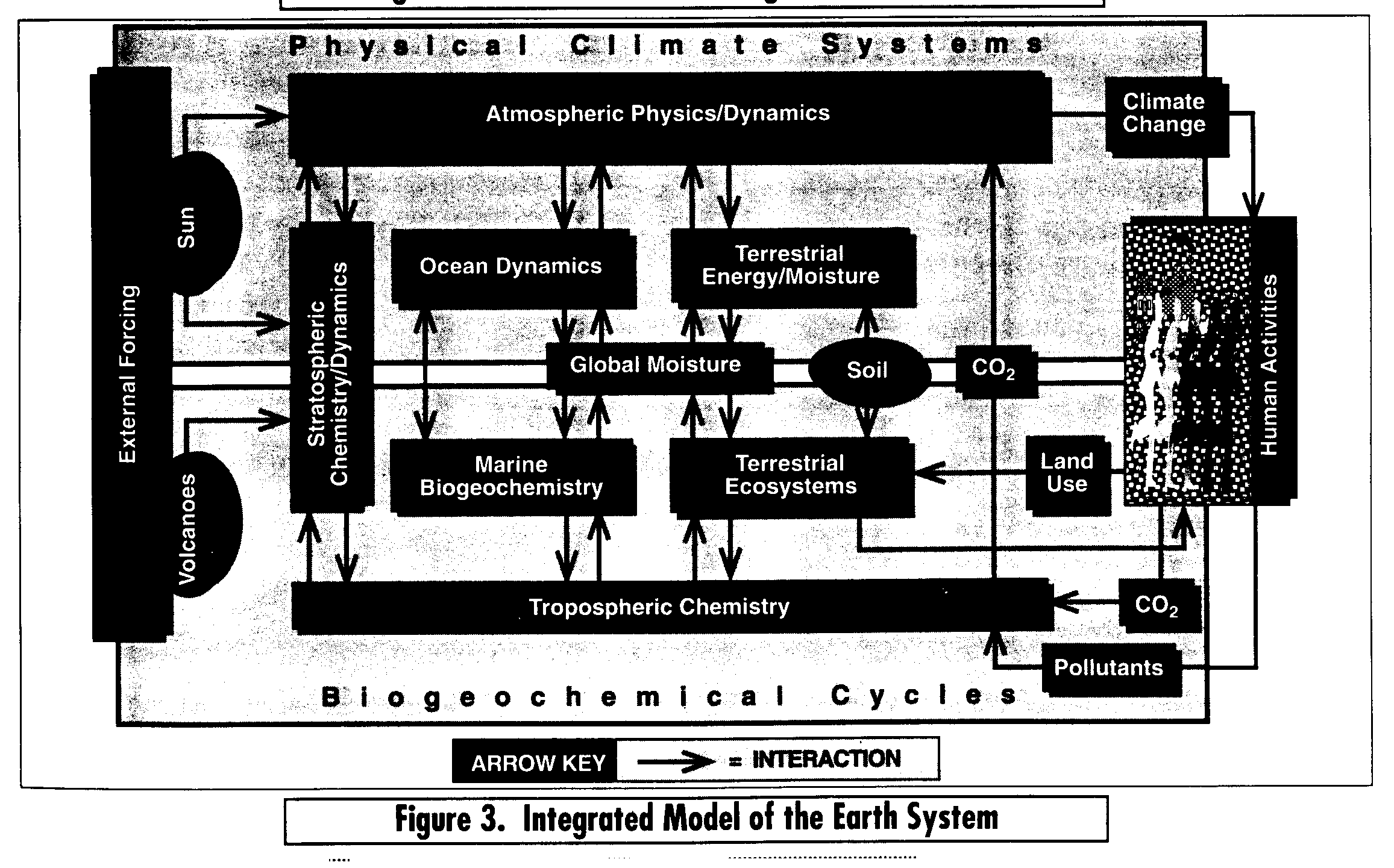
The data collection segment of MTPE--EOS, Earth Probes, geostationary satellites, and ground-based programs--will provide the comprehensive global observations necessary to understand how the processes that govern global change interact as parts of the Earth system. Through this refined knowledge, models will be developed to help predict future environmental change on local, regional, and global scales. For those who make observations of the Earth system and develop models of its operation, Earth system science means the creation of interdisciplinary models that couple elements from formerly disparate sciences, such as ecology and meteorology. Figure 3 provides a conceptual model of the Earth system.
The EOS Program provides resources to support the scientific research required to turn satellite measurements into science data products for inclusion in or validation of models; specifically, EOS supports scientific investigations through its Interdisciplinary Science Investigations and instrument teams:
Refer to the EOSDIS Architecture section for a discussion of the different types of products to be made available as EOSDIS evolves to a full operational capability.
EOS investigations are intended to characterize the Earth system as an integrated whole, while also quantifying the regional processes that govern it. Research will be based initially on the existing sources of ground- and space-based observations (see Pathfinder Data Sets section), and will continue through and beyond the launch of the EOS satellites. Efforts to understand these Earth system elements will shed light on how the Earth functions as a coupled and integrated system, how it responds to human-induced perturbations, and how this response manifests itself as global climate change.
NASA's long-range planning calls for continuation of MTPE into the next century. These plans include a new generation of satellites in geostationary orbit and additional Earth Probe satellites addressing specific Earth science investigations. Of course, the data system aspects of MTPE will continue throughout and beyond the lifetime of the EOS mission.
In addition to the approved Earth Probes missions identified in Table 1 (i.e., TOMS, NSCAT, and TRMM), several mission categories have been identified to provide critical Earth science measurements not provided by the international constellation of satellites. NASA intends to pursue collaborations with domestic and/or international partners in the following disciplines: Gravity and magnetic fields, solid Earth topography, and ocean topography. A follow-on to TOPEX/Poseidon is being actively sought to satisfy the latter category. Specific instrumentation and platforms have yet to be identified for the other two. Additional Earth Probes will be launched as particular observations are requested by the international science community, or as data gaps develop. The main driver behind this program is to provide focused missions in a faster, better, and cheaper manner, alleviating lengthy procurements. These small- to moderate-sized satellites will have extremely focused objectives, and obtain measurements that are not possible with EOS or other instrument suites.
As currently envisioned, NASA's Geostationary Platform Program entails a constellation of five satellites making continuous observations currently with the polar-orbiting EOS satellites. The Geostationary Earth Observation (GEO) platforms are required to resolve dynamic processes that operate on the scale of minutes to hours, to detect unpredictable short-term events, and to observe weak signals that can only be detected by instruments capable of "staring" for relatively long periods. Much as geostationary weather satellites track storm systems today, these platforms will monitor dynamic short-term phenomena that cannot be observed from polar or low-inclination orbits. The science objectives for the geostationary platforms will complement those of the polar-orbiting and inclined orbit missions by improving understanding of short-term processes, which will then be interpreted into global Earth system models.
EOS and Earth Probes will provide high spatial resolution global information, and geostationary platforms will provide a time-continuous database over the full Earth disk. The various orbits of these space-based elements of MTPE will give Earth scientists as cohesive a set of observations--at all spatial and temporal scales--as possible on Earth system processes.
MTPE offers a new perspective on the functioning of planet Earth through coordinated, long-term, space-based and in situ observations, and a program of interdisciplinary research addressing priority issues of Earth system science. This Presidential Initiative is supported by Congress, which granted NASA a "new start" budget line item for the EOS Program in 1990. Following this mandate from the Administration and Congress, NASA has placed itself at the forefront of Earth observations satellite technology development and data management. The improved measurement and modeling capabilities that result directly support the U.S. and international global change research programs, and reinforce NASA's position as a world leader in space-based remote sensing.
The remainder of this Handbook describes the elements comprising the EOS mission in greater detail--its scientific foundations and the specific plans for bringing mission concepts to reality.
The EOS Program has undergone major revision since the last edition of this Handbook was published. The EOS chronology section provides an overview of the reconfiguration of the program, which resulted from a congressional mandate to substantially reduce the budget through 2000. The EOS Science section addresses the interdisciplinary focus on global climate change, a consequence of honing overall program objectives. A Pathfinder Data Set section has been added to inform readers of what is being done now to further global change research. Interagency cooperation in EOS has been strengthened through National Space Policy Directive 7, which established the Space-Based Global change Observation System (S-GCOS). The Interagency coordination/cooperation section addresses this recent development. Finally, the reader should pay particular attention to the Mission Elements section, which provides details of the international instrument suites that comprise IEOS. This section provides as comprehensive and up-to-date coverage as possible given the transient nature of payload configurations imposed by constrained national budgets the world over. This section and the EOS Instruments section describe the current Earth remote-sensing satellite scenario and the instrumentation that will yield the observations needed to further global change research.