 Reproduced, with permission, from:
National Aeronautics and Space Administration (NASA). 1993. Earth Observing System (EOS) Reference Handbook, ed. G. Asrar and D. J. Dokken. Washington, D. C.: National Aeronautics and Space Administration, Earth Science Support Office, Document Resource Facility.
Reproduced, with permission, from:
National Aeronautics and Space Administration (NASA). 1993. Earth Observing System (EOS) Reference Handbook, ed. G. Asrar and D. J. Dokken. Washington, D. C.: National Aeronautics and Space Administration, Earth Science Support Office, Document Resource Facility.EOSDIS will manage the data resulting from NASA's Earth science research satellites and field measurement programs, and other data essential for the interpretation of these measurements. EOSDIS will supply data archive, distribution, and information management services; for EOS satellites, EOSDIS will also provide data product generation and command and control functions. EOSDIS will provide data sets generated by assimilation of applicable observations into global climate models. To this end, EOSDIS must perform a wide variety of functions, supporting individuals located in various organizations and carrying on several distinct types of activity including:
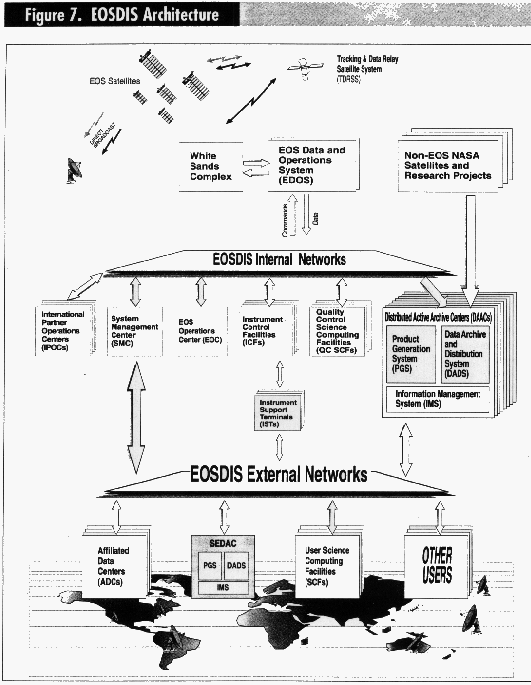
These groupings of functions and activities together with their interrelationships are illustrated in Figure 7. Multiple boxes indicate distributed capabilities. For instance, data use in research, algorithm development and maintenance, and data product generation, archiving, and distribution are carried out in many different locations, while mission planning, scheduling, and control take place at one site [i.e., the EOS Operations Center (EOC)].
NASA is implementing EOSDIS using a distributed, open system architecture. This allows for the distribution of EOSDIS elements to various locations to take best advantage of different institutional capabilities and science expertise. Although EOSDIS is physically distributed, it will appear a single logical entity to the user. EOSDIS will consist of an EOSDIS Core System (ECS) to provide centralized mission and instrument command and control functions, and distributed (but common) product generation, archive, and information management functions. Capabilities also exist outside of the core, including site-unique extensions to core capabilities, computing facilities for EOS researchers, and so on. As can be seen in Figure 7, the EOSDIS architecture is composed of several types of elements, most of which will be geographically distributed, thereby providing a resilient program. The following paragraphs provide details on each of the components making up the data system. They should not be considered a prioritized ranking; rather, each functions proves invaluable in the successful implementation of EOSDIS.
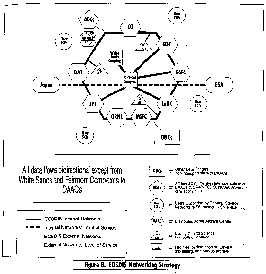
Internal and External Networks. The large, distributed community of Earth scientists and other users requires large network capacity and broadly available, easy connectivity. This is the function of the EOSDIS External Network. In implementing the external network, NASA is currently using NASA Science Internet and its connections to the National Science Foundation (NSF) Internet, and will make maximum use of the National Research and Education Network (NREN) as it develops. The interconnection of the EOSDIS elements requires a secure, high-bandwidth network functioning in a controlled manner to enable the various elements to support one another in a timely fashion and to support communication with the satellites. The EOSDIS Internal Network will meet these requirements. Figure 8 illustrates the internal and external network connections that must be made, but not necessarily the actual architecture of backbone and tail circuits.
Science Computing Facilities (SCFs). After networks, the key item determining the nature of EOSDIS access will be the type of equipment required to support the user interface. For the primary user community of environmental researchers, SCFs will provide this capability. SCFs will range from personal workstations to supercomputers supporting algorithm development and other EOSDIS functions. To enable access from a wide variety of researchers, EOSDIS will make available to users software toolkits that can be run on computers readily affordable within typical research grants. These toolkits will facilitate access to EOSDIS services and, in some cases, allow local provision of EOSDIS services. EOSDIS will provide access and as many services as possible to users who possess as little as a personal computer and modem. Many other sources, both within and external to NASA, will provide research funding for computing equipment and communications to support the needs of the Earth science community.
Quality Control (QC) SCFs. QC SCFs include special software to enable investigators responsible for standard product algorithms to perform scientific quality a control of their products. Located at the investigators' home institutions, these SCFs will be connected to the EOSDIS internal network.
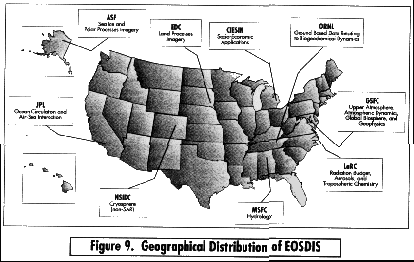
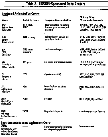
Distributed Active Archive Centers (DAACs). Eight DAACs covering various types of Earth science data have been selected by NASA to carry out the responsibilities for processing, archiving, and distributing EOS and related data and for providing a full range of user support. These institutions ensure that data will be available indefinitely in an easily usable form. Acting in concert, DAACs will support global change researchers whose needs cross traditional discipline boundaries, while continuing to support the particular needs of the discipline community. DAAC assignments were based primarily on the current distribution of scientific expertise and institutional heritage and capability (see Figure 9); the planned responsibilities of these centers are listed in Table 8. Each EOS DAAC contains functional elements that include a Product Generation System (PGS), a Data Archive and Distribution System (DADS), and an Information Management System (IMS). These elements include a common "core" set of functions provided by the distributed ECS, and also some DAAC-unique extensions required to support each DAAC's discipline user community. Other Federal agencies may share management and funding responsibilities for the active archives under terms of agreements negotiated with NASA. During the EOS operational lifetime and beyond, NASA may make arrangements to transfer responsibility for some or all EOS data and products from EOS active archives to permanent archives.
Socio-Economic Data and Applications Center (SEDAC). An additional center--Consortium for International Earth Science Information Network (CIESIN)--receives funding from NASA to act as a link between the EOS Program and the socio-economic/educational user community. The data acquisition, processing, archival, and data distribution functions at CIESIN are similar to those carried out by the eight DAACs; however, SEDAC is connected to EOSDIS only via the external network. Figures 7 and 8 illustrate the role of CIESIN within the overall framework of EOSDIS.
EOS Data and Operations System (EDOS). This distributed component of EOSDIS provides for command uplink and data capture through NASA's Tracking and Data Relay Satellite System (TDRSS) at the White Sands Complex in New Mexico, and production processing of EOS data at a facility in Fairmont, West Virginia. Production processing involves the separation of composite downlink transfer frame data streams into individual payload/instrument data packet streams (i.e., Level 0 processing). EDOS also provides a long-term backup archive of the Level 0 processed data. The uplinking of commands to and the acquisition of Level 0 data from EOS instruments on the international partner satellites will be handled via interfaces to the respective ground systems.
EOS Operations Center (EOC). This center is responsible for mission control, mission planning and scheduling, instrument command support, and mission operations. All communications with the platforms and instruments go through EOC
International Partner Operations Centers (IPOCs). These centers perform functions similar to those of EOC for the international partner observatories.
System Management Center (SMC). In coordination with the DAACs, SMC ensures appropriate data flows, and manages production schedules and resource usage. Its functions include configuration management; high-level scheduling of system, site, and element activities; monitoring of production and performance; resolving faults; security; and accounting and billing.
Instrument Control Facilities (ICFs). These facilities consist of several Instrument Control Centers (ICCs). Each ICC plans and schedules instrument operations, generates and validates command sequences, provides the capability to forward commands and to store them for later transmission, monitors the health and safety of instruments, and provides instrument controllers with status information on their instruments. The international partner ICCs will perform similar functions for their instruments on EOS spacecraft.
Instrument Support Terminals (ISTs). Residing at Instrument PL and Team Leader sites, ISTs are used to access ICCs for information on the health and safety of individual instruments. They enable PLs and their engineering support teams to provide command inputs to the ICCs, and to participate with instrument and mission controllers in the diagnosis and resolution of performance anomalies.
Field Support Terminals (FSTs). FSTs will provide mobile communications to coordinate platform data acquisition with field experiments and the necessary display capabilities to support field campaigns.
Product Generation System (PGS). This DAAC element performs data processing functions, including routine generation of standard products, quick-look products, metadata, and browse data sets. These operations also extend to reprocessing of data and retrospective production of new standard products. Computational support for other activities, including research and special product trials, can also be included in these facilities.
Data Archive and Distribution System (DADS). This DAAC element is responsible for archiving and distributing EOS data and information, including Level O and higher data products, ancillary and correlative data, metadata, command histories, algorithms, and documentation. Data will be distributed from DADS to EOS scientists, other EOS facilities, and other research users electronically via networks or on high-density storage media (e.g., optical disks), depending on the requested volume.
Information Management System (IMS). As the user interface, IMS provides information about EOSDIS data holdings on a 24-hour basis; provides pointers to external archives with which EOSDIS interoperates; accepts user orders for EOS data; provides information about future data acquisition and processing schedules; accepts and forwards data acquisition and processing requests; and maintains information on system status, management, and coordination. The IMS will be distributed to individual DAACs; however, in keeping with the transparent user interface, researchers accessing IMS will see the same comprehensive "Earth science" view of the overall EOSDIS database, spanning the holdings of all the DAACs.
Affiliated Data Centers (ADCs). These non-EOS data centers will provide special access to non-EOS data or to special non-EOSDIS services required by the EOS Program. Examples of planned ADCs include NOAA/National Environmental Satellite, Data, and Information Service (NESDIS) national data centers, and the NESDIS GOES archive at the University of Wisconsin.
A Permanent Archive. Funded independent of the EOS budget, this type of facility may take responsibility for the permanent archiving and user services for EOS data and products during and beyond the scope of the EOS mission. Agreements with these archives will be negotiated by NASA Headquarters, with EOS Project coordination, and these agreements will become part of the EOS Project Data Management Plan. Examples of permanent archives include USGS/EDC and NOAA/NESDIS.
User needs for EOSDIS will become more clearly understood as researchers work with and respond to early versions of the system; undoubtedly, user needs will change over time. New information systems technology will continually emerge, including new database and information management technology applicable to Earth science data as well as faster processors and more capable networks. To succeed over its lifetime, EOSDIS must be responsive to change; its design and the implementation process must facilitate change even while supporting ongoing operations and user services. Development and prototyping will continue throughout the life of the system.
The EOSDIS design will maximize openness to change through the incorporation of layering and standards, and vendor independence to the fullest extent possible. The prototyping program will allow new features, functions, and implementations of new technology to be tested and evaluated in a near-operational setting, with successful prototypes implemented in the operational EOSDIS. EOSDIS evolution has already begun with work on Version 0, and will continue with the subsequent versions described below.
EOSDIS Version 0. This working prototype (with some operational elements) is being developed between 1991 and 1994. This system interconnects existing Earth science data systems via electronic networks, interoperable catalogs, and common data distribution procedures to provide better access to existing and pre-EOS data. Starting with existing heterogeneous Earth science data systems, Version O will evolve toward the full EOSDIS by taking maximum advantage of existing experience and by ensuring that no disruption in current user services occurs. Through interconnection of the existing systems, Version O serves as a functional prototype of selected key EOSDIS services. As a prototype, it does not have all the capabilities, fault tolerance, or reliability of later versions; however, EOSDIS Version O supports use by the scientific community in day-today research activities. Such use tests existing services to determine what additional or alternative capabilities are required of the full EOSDIS. Operational use of Version 0 is expected in mid-1994.
EOSDIS Version 1. This version will be implemented in steps over the 1995-1997 time frame. It will be designed and developed while Version 0 is operating, thus benefiting from Version 0 user feedback. Version 1 will be physically distributed, but the system will appear completely integrated to users and will provide researchers with the complete set of capabilities needed for EOS science and mission operations. The new capabilities of the Version 1 data and information system will progressively replace (after a period of parallel operations) the Version 0 system to provide smooth and transparent transition to enhanced services.
EOSDIS Version 2. EOSDIS Version 2 will be implemented before launch of the first EOS satellite in 1998. The mission and instrument command and control functions and product generation functions discussed above will be greatly enhanced, and full capacity will be available to support all functions for the first EOS platform.
Subsequent versions of EOSDIS will supplement capacity and service as required by EOS spacecraft launches. EOSDIS capabilities will be evaluated continually by the research community, and technology will be refreshed or augmented as the need arises.
Standard DATA Products. Data products that are generated as part of a research investigation using EOS data, are of wide research utility, are routinely generated, and in general are produced for spatially and/or temporally extensive subsets of the data are to be considered standard data products. All EOS instruments must have standard Level 1 data products, and most will have standard Level 2 data products. Some EOS interdisciplinary Science Investigations will also generate standard data products. Specifications for the set of standard data products to be generated by the EOS Project will be reviewed continuously by EOS IWG and NASA Headquarters to ensure completeness and consistently in providing a comprehensive science data output for the EOS mission. Standard data products will normally be generated in the EOS PGS elements. The list of data products to be available prior to launch of the various EOS platforms is currently under revision, and will be included in the 1994 edition of the EOS Reference Handbook.
Special Data Products. Data products that are generated as part of a research investigation using EOS data and that are produced for a limited region or time period, or products that are not accepted as standard by EOS IWG and NASA Headquarters, are referred to as special data products. Special data products will normally be generated at investigator SCFs. Special products may be reclassified later as standard products upon review and approval by EOS IWG and NASA Headquarters; in which case, the algorithms and processing will migrate to the PGS elements and be placed under the appropriate configuration controls.
Level Definitions. The various levels of data referred to in this document are identical to those defined by the EOS Advisory Panel in its report and are consistent with the committee on Data Management, Archiving, and computing (CODMAC) definitions. For some instruments, there will be no Level 1B product that is distinct from the Level 1A product. In these cases, the reference to Level 1B data can be assumed to refer to Level 1A data. Brief definitions follow: