 Reproduced, with permission, from: Freeman, P. H., and R. Fox. 1994. Satellite
mapping of tropical forest cover and deforestation: A review with recommendations
for USAID. Arlington, VA: Environment and Natural Resources Information Center,
DATEX.
Reproduced, with permission, from: Freeman, P. H., and R. Fox. 1994. Satellite
mapping of tropical forest cover and deforestation: A review with recommendations
for USAID. Arlington, VA: Environment and Natural Resources Information Center,
DATEX.
A Project of DATEX Inc.
Satellite imagery is being harnessed to the task of mapping tropical forests, deforestation, and forest biomass. This report reviews four ongoing efforts by the United States and others to map tropical forests worldwide and track forest cover change with satellite imagery. The report analyzes the implications of this work and the information beginning to flow from it for USAID's programming and project support in biodiversity and tropical forest conservation. Potential uses include identification of strategically important areas for assistance, monitoring forest cover change in protected or critically important areas, and use of imagery as a common frame of reference for planning and coordination of conservation actions.
Recommendations are made on the use of remotely sensed information and GIS technologies for addressing global conservation issues. It is recommended that USAID: 1) become more knowledgeable about these technologies and their applications, 2) use results of ongoing forest mapping for programming assistance, 3) support ongoing forest cover mapping by "ground-truthing" image analysis where USAID field projects are active, 4) disseminate within USAID information about forest mapping efforts, 5) use satellite images for planning and monitoring field actions, and 6) use GIS and satellite imagery for facilitating donor coordination.
This report reviews four major efforts to map tropical forest cover from space, and the promise as well as problems related to using remote sensing, geographic information system (GIS) software and hardware, and new and more powerful computers for this purpose. The four mapping efforts are NASA's Pathfinder program, the Commission of European Communities' TREES program, the South American PANAMAZONIA program, and U.N. Food and Agriculture Organization's World Forest Resources Assessment work. These mapping efforts are analyzed against a background of factors related to remote sensing and GIS technologies in the fourth section of this paper. In the fifth section implications for USAID are analyzed and the paper concludes with six recommendations for integrating the knowledge and tools of remote sensing technologies and ongoing surveys into USAID program planning and project assistance concerned with biodiversity and tropical forest conservation.
Background
During the past twenty to thirty years, the vast realm of tropical forests has been succumbing to agricultural land clearing and the logger's saw. Now -- at the end of the 20th Century -- that we have taken measure of the planet we are aware of the global consequences, as distinct from our limited appreciation in the past of deforestation impacts in North Africa, Europe or the eastern United States. We now know that massive deforestation carries great costs: probable exacerbation of global climate change and loss of much of the planet's genetic legacy. These realizations have spurred international actions in recent years to conserve tropical forests and to determine their role in climate change.
USAID and other development assistance organizations have mobilized unprecedented efforts to curb destruction of tropical forests and preserve their biological resources. To plan and track these efforts requires knowledge of the rate and pattern of deforestation as well as of the total forest resource. Lacking that knowledge USAID can neither act effectively nor gauge the results of its actions. In addition, the effect of tropical deforestation on the earth's carbon cycle and on global climate remains ill-defined until more precise estimates of carbon stored in forests and lost to deforestation can be made. Acquiring this knowledge on a Pan-tropical scale requires a coordinated mapping and assessment effort.
Until recently, assessments of tropical forests and their change have had to be estimated from a variety of sources, few accurate maps, and disparate years of observation. The result has been widely varying estimates of tropical deforestation, from a high of 20.4 million hectares per year to a low of 15.5 million hectares per year [3]. Presented in table format, these quantitative measures lend scant guidance to forest protection planning and management.
The importance of maps
To comprehend and assess the role of tropical forests and deforestation with respect to global climate or biodiversity, comparable maps of all the tropical forests are needed. Further, maps of the extent of tropical forests for at least two points of time must be mapped so as to reveal the rate and pattern of deforestation. Also, to estimate tropical forest biomass, the extent of forests of different biomass volume must be mapped. Finally, to track future progress in slowing deforestation, maps are needed that plot changes detected from space or on the ground.
Mapping and monitoring of tropical forests cover on a global basis can only be done with remotely sensed images and geographic information system (GIS) tools that plot and calculate the results of image analysis. Imagery from NASA's Landsat satellites has been obtained for most of the tropical world on a more or less continuous basis since 1973. These images provide a 20-year time series that allows a before and after analysis for a period of unprecedented change in tropical forest cover. From analyses of these images and other data, maps are being compiled that show the extent of forests and the pattern of deforestation, described later in this paper. Complementary maps of forest management zones, parks, protected areas, and other significant features such as transportation grids are also needed for conservation planning and climate change research.
Technical, methodological, and, eventually, political complexities described in this section have characterized efforts to map tropical forests from space. Early satellite images fell short of initial expectations. Higher resolution imagery arrived in the early 1980s when tropical nations were resisting pressure to slow deforestation. International consensus over the gravity of tropical deforestation did not emerge until later in the decade when the focus of attention shifted to global climate change. Meanwhile remote sensing and GIS technologies have been evolving at an accelerating pace, making it difficult to manage comparable, multi-year global mapping efforts.
The last 20 years mark the emergence, evolution, and proliferation of satellites designed to monitor the earth and its environment -- the National Aeronautic and Space Administration's (NASA) Landsat series, the French SPOT satellite, the National Oceanic and Atmospheric Administration's (NOAA) TIROS weather satellites and others launched by the European Space Agency, India, Japan and the former USSR. For individual countries or areas some of this imagery has been used to detect forest loss, for instance in the Ivory Coast, portions of the Brazilian Amazon, and in Thailand, where logging has now been banned. However, satellite imagery in the 1970s produced data of far coarser resolution and at scales far smaller than the aerial photographs with which foresters and resources managers were accustomed to working. The imagery fell short of early expectations of its usefulness for resource inventories. At the same time the impetus to monitor forest cover change had not yet materialized.
On a global scale, the use of remote sensing to map deforestation and forest cover has only just begun. It was the explosion of national and international interest in global climate change that spurred efforts to map tropical forests from space. This has led to a number of simultaneous mapping efforts, some overlapping, distinguished by differences in image analysis methods and classification schemes.
Complex and rapidly evolving technologies
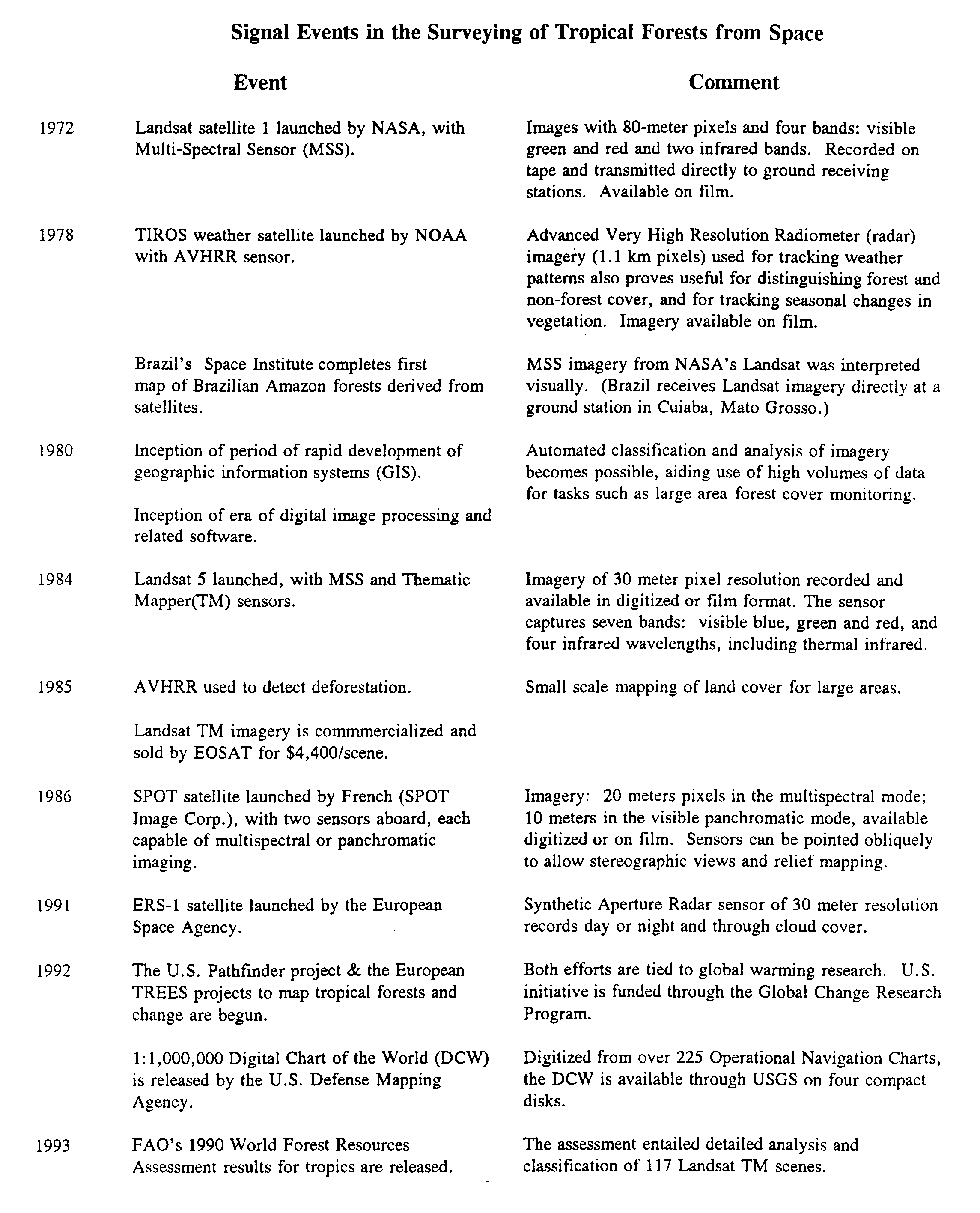
Satellite sensor-based mapping of tropical forest cover worldwide is clearly a massive effort, yet one that is extremely sensitive to the rapidly evolving technologies that characterize this field. Table 1 tracks some of the key events. A strong advance in one technical area, such as higher resolution sensors or automation of image classification, can dramatically change another, such as computer hardware and software requirements. The dynamic interplay of these technologies has exerted a strong influence on global forest cover change detection and mapping, compelling continuous innovation of mapping methods.
Remote sensing, analysis, and mapping technologies are evolving rapidly [4]. Among other features are the continuous development and deployment of ever more detailed and versatile sensors; the development of image analysis software; the expected declassification of certain imagery or sensor technology [5] to permit higher resolution images, commercial computer hardware and software developments that are occurring at a dizzying pace; and the rapid development during the past decade of GIS, including the recent creation of global scale digitized base maps. Increases in the speed and memory of personal computers(PCs) and the development of PC-based GIS software have put satellite imagery analysis at the fingertips of individual researchers whereas in the past only well-funded laboratories could aspire to such work.
The accuracy of remotely sensed data is increasing. It is a function of resolution [6] and electromagnetic spectra sensed, and advances have occurred on both fronts. Since 1973 pixel [7] sizes have gone from 80 meters on a side (the Landsat MSS sensor) to 10 meters on a side (the SPOT IMAGE sensor), and new imagery with 3 meter pixels and less is to be acquired in the near future. Also, one "peace dividend" of the Cold War has been the declassification of existing inventories of high resolution imagery, including imagery from the former USSR -- already being marketed by a consortium of Russian, Canadian and U.S. firms [8] -- as well as imagery from the U.S. Central Intelligence Agency.
From an initial four electromagnetic bands Landsat sensors have increased to seven to include visible blue and thermal red. Radar sensors, such as those aboard the ESA's ERS-l satellite, penetrate the cloud cover that frequently obscures rainforests, and SPOT's sensors (two are aboard) can be pointed to achieve stereographic coverage, making topographic mapping from space possible. NASA is now testing two new sensors -- the Airborne Synthetic Aperture Imaging Radar (AIRSAR) that can detect crops under native trees, and the Airborne Visible and Infrared Imaging Spectrometer (AVIRIS) which registers data from 224 electromagnetic bands, permitting analysis of chemicals in vegetation.
These advances are none too soon, as tropical nations endeavor to better manage forests. The depiction of forest cover on a continental scale (1:1,000,000 or smaller), e.g. of the Amazon or Central Africa, can be accomplished with low resolution imagery and digital image processing, as exemplified by Woods Hole Institute mapping of South American forest cover with 1.1 kilometer resolution NOAA satellite imagery (Advanced Very High Resolution Radiometer or AVHRR). Driven primarily by interest in global carbon cycle modelling, the coarse resolution of the imagery results in generalized vegetative classifications. At the same time, improved national forest conservation and management programs are being put in place in virtually all tropical nations. Many are strongly supported by international non-governmental organizations such as the World Conservation Union, the World Wildlife Fund, and Conservation International, as well as the development assistance community. These national conservation programs require relatively large scale maps (1:250,000 [9] or larger) that depict biologically and ecologically significant formations, including changes over time as influenced by natural and human events. To be useful for planning, these maps usually include other land uses and related concerns. Monitoring conservation progress is also creating a burgeoning demand for mapped information on land uses and natural resources of greater spatial as well as temporal resolution. These demands are challenging the technical frontiers of satellite imaging and analysis methods as well as institutional abilities to manage and communicate information.
The delayed employment of satellite technology for global forest cover mapping
Remote sensing and mapping technologies are only now -- 20 years after the launch of Landsat-l -- being harnessed to the task of a common world map (or a series of continental maps) of tropical forest cover change. Even most national level attempts to measure the extent of forest cover with the help of satellite imagery -- virtually all of which have been collected and used by the FAO for its Forest Resources Assessment work -- have failed to measure changes. According to FAO's Paul Howard, "no single tropical country has carried out a national forest inventory containing information that could be used for reliable estimation of woody bio-mass volume or...forest cover change." [l0]
Initially, methodological problems interfered with the effective use of remotely sensed images. In 1973 when Landsat's Multi-Spectral Scanner (MSS) imagery first became available, methods to interpret and classify images had to be developed. Initially, visual analysis and classification on photographic reproductions of the imagery was the norm. Measurements had to be conducted on the ground to determine the spectral "signature" of different kinds of vegetative and non-vegetative cover to guide imagery analysis. Work on ground truthing in the tropics lagged behind work in higher latitudes. In Brazil, where a Landsat ground receiving station has supplied imagery of the Amazon since the early 1970s, the first forest cover survey (using MSS imagery, bands 5 and 7) of the Amazon by INPE (the Brazilian Space Research Institute) was not complete until 1978.
The relatively coarse resolution of the MSS imagery (80-meter pixels) limited interpretations of vegetative cover to generalized classifications. Although adequate for detecting major changes in land cover (e.g. forested vs. non-forested), most satellite-based forest mapping in the 1970s was motivated by forest resource management needs that require more detail than is revealed by the imagery. Information compiled by the United Nations Food and Agriculture Organization in the course of examining all available maps on tropical forest cover worldwide revealed that the accuracy of MSS imagery-assisted inventories in the 1970s and 1980s was more a function of complementary field work and aerial photo interpretation than the information provided by the imagery. Even into the 1980s after the availability of higher resolution Thematic Mapper imagery, reliability varies greatly among different inventories that have employed imagery [11].
In the past ten years the utility of satellite based imagery has increased dramatically with improvements in resolution, digital image processing, modelling, and GIS applications. Now, in addition to monitoring change in forest cover, remote sensing technology is being used in the northern latitudes for such purposes as inventory mapping and updates, forest sampling and plot analysis, regrowth monitoring, and insect and disease management.
Cost of the technology has entered into the equation, probably delaying its application to large area forest cover mapping. The Thematic Mapper imagery, provided with the launch of Landsat 4 in 1982 was commercialized in 1984. Its price jumped from the cost of reproduction to $3,600 and later $4,400 per scene (for all seven bands), making the data virtually inaccessible except for high priority research and surveys. To process, analyze, and convert the data to map format requires high speed, large capacity computer work stations, image processing and GIS software, and special printers, with total costs of roughly $150,000 to $200,000. Developing country agricultural ministries, and particularly their forestry departments, have not been able to afford such equipment. Special research institutes, such as INPE in Brazil, NASA in the U.S.A. and the European Joint Research Center in Ispra, Italy have been the centers of such activity.
Political forces to slow tropical deforestation entered into play in the 1980s, partly as a consequence of higher quality imagery supplied by Landsat's Thematic Mapper. The fast pace of deforestation in Rondonia, Brazil during the mid-80s was detected in dramatic TM images that revealed the consequences of penetration roads into primary forests of the Amazon in a few short years. However, national and international resolve to effectively hold the line on deforestation did not harden until the late 1980s and had to compete with the reluctance of tropical nations to bow to international concerns over biodiversity loss as well as the booming market in tropical hardwoods.
Even in the U.S. and Europe where the technologies and methods originated, the political support needed to mobilize public monies to undertake global level satellite-based forest surveys was absent. FAO had to carry out its recent world forest resources assessment with minimal resources. Only with the initiation of research on global climate change, did funds become available to map forests over large areas of the tropics.
The five phases of tropical forest mapping from space
Some perspective can be gained by examining these events and considerations over time and projecting them into the near future. Five development phases, slightly overlapping, appear to characterize the development of satellite imagery and its use for tropical forest cover mapping.
The calibration or validation of various global models, especially of the carbon cycle and of global climate will mark this phase as well. The resulting improved projections and timetables of climate change will exert an important influence on national and international decisions concerning greenhouse gas emissions.
Four ongoing surveys of tropical forest cover and tropical deforestation are briefly described next. A detailed survey and description of these efforts has also been compiled in an atlas format index under a separate cover [l4]. Early results of these multi-year surveys are already revising previous estimates of deforestation rates.
Pathfinder. The Pathfinder survey is sponsored by NASA and the U.S. Environmental Protection Agency (EPA). It is one piece of the global carbon research of the U.S. Global Change Research Program that is developing the scientific basis for policies related to global change. Underway since 1992, Pathfinder mapping will cover 75 percent of the world's tropical forested area. The program's researchers will measure tropical forest cover and change at three points in time -- early 1970s, 1980s and 1990s -- on all the continents. The mapping is being implemented as two parts, one by NASA's Goddard Space Flight Center, with university-based researchers as partners, and the other by EPA researchers.The first of the two Pathfinder sub-projects is being carried out by the Universities of Maryland and New Hampshire. They are acquiring and interpreting approximately 2,700 Landsat images (900 images at three points in time) to determine tropical forest cover and change in Southeastern Asia (University of New Hampshire), South America and Africa (University of Maryland). USAID has underwritten some of the work corresponding to Central Africa. Preliminary results of work in South America and Central Africa have already been published [l5].
In the second sub-project, tropical forest cover of Mexico, Central America and the Caribbean is being mapped by the EPA as part of a land cover map of North America. EPA researchers in Las Vegas, Nevada will map ground cover and vegetative change. This work was just getting underway in the Fall of 1993.
In both cases vegetation will be classified into six categories -- forest, nonforest vegetation, deforested areas, regenerated forest cover, cloud and water cover and "unknown".
FAO. Satellite imagery figured strategically in the FAO's decennial World Forest Resources Assessment, whose report for tropical countries was published in November 1993 [l6]. The assessment employed Landsat satellite imagery to analyze forest cover at two points in time (1981 and 1990) for a 10 percent sample of the world's tropical forests. The sample comprised 117 sites statistically chosen from four broad ecological zones (tropical rainforest, moist deciduous forest, dry deciduous forest, and upland formations). For each site comparable Landsat scenes for the two dates were acquired, analyzed, and field checked. The objective was to provide more precise estimates of forest cover and change at the regional and global levels than would be possible with existing data. Thirty-one of the 47 sample sites in Africa had been analyzed by the end of 1993 and the results are reported in the report mentioned above; work continues in other regions.
The analytical results and other available information are being merged into a GIS system that identifies four classes of natural woody vegetation (continuous closed canopy and continuous open canopy forests, fragmented forests, and shrubs) as well as forest plantations. FAO measured change in these types of cover during the interval of study and, among other analyses, interpreted change as a function of population density.
The assessment also employed AVHRR imagery and analysis in West Africa and the Amazon to study the effect of forest fragmentation on forest degradation and, by inference, biodiversity loss.
TREES. The TREES [l7] project is sponsored by the European Space Agency and the Commission of European Communities (CEC). The project, based at the CEC's Joint Research Center in Ispra, Italy, is also mapping global tropical forest cover. The work manifests the European community's concern over the relationship of global warming and forest cover loss. To some extent it duplicates the Pathfinder efforts to map forest cover, however the methods and the time frame differ.
TREES aims initially to establish a baseline of tropical forest cover for the late 1980s on the basis of 1.1 kilometer resolution Advanced Very High Resolution Radiometer (AVHRR) imagery, available from NOAA (at a cost of $100 per scene) and from TIROS satellite ground receiving stations around the world. Validation of image classification will employ the results of the FAO sample scenes as well as by "nesting" higher resolution SPOT and Landsat TM imagery into the AVHRR scenes.
A second phase of TREES will then monitor active deforestation areas, identified with AVHRR imagery, by means of higher resolution images from the European ERS-1 satellite, SPOT and Landsat. A third phase of TREES will model tropical deforestation, examining the dynamics and biospheric role of tropical forests.
AVHRR imagery was selected to determine forest cover and change in the mid-1980s as an alternative to the high cost of the commercialized Landsat imagery. Initial success led to the foundation for the TREES project. While other organizations also use the AVHRR resource, such as The Woods Hole Research Center, TREES seems to be the leading proponent [18].
The TREES project plans to model factors affecting tropical deforestation, including population. However, as in the case of data on forest cover change over time, time series of demographic data of sufficient detail, i.e. for the smallest sub-national units, are also lacking or unavailable for analysis. Coordinated efforts have recently begun to compile the most detailed demographic data possible, under the aegis of CIESIN [19], and, like ongoing U.S. efforts to map tropical forest changes, the data compilations are underwritten by the U.S. Global Change Research Program [20].
PANAMAZONIA. The PANAMAZONIA project is a large-scale South American effort to map the forest cover of the Amazon Basin at two points in time (mid-1980s and late 1980s), and will distinguish only forest and nonforest vegetation. Areas deforested during the period will be plotted. A completion date has not been set. This survey, led by Brazil's INPE, involves the cooperation of eight Amazonian Basin countries. Independently of this effort INPE has surveyed forest cover in the Brazilian portion of the Amazon basin since 1978. Much of the project consists of training by Brazilians of neighboring country technicians in satellite image interpretation methods and the mapping of those portions of the Amazon falling within their boundaries.
Together these mapping efforts cover most of the world's tropical forests at comparable levels of detail and time periods. An exception is the forests of Central Africa which lie in the one area of the tropics lacking a Landsat ground receiving station. Few images of the area have been recorded and downloaded to other receiving stations, and consequently there is poor MSS and TM coverage over time. Coverage is poor for the 10-meter resolution panchromatic sensor aboard the continuously recording SPOT satellite as well, due to cloud cover in the lower Congo Basin. Only small-scale AVHRR imagery is available for long-term comparison (since approximately 1979).
The results of the FAO assessment are now available [21]. The FAO now estimates that 15.4 million hectares of tropical forest were lost each year between 1981 and 1990. Yearly loss by earlier FAO estimates was 11.3 million hectares. Yearly loss of tropical moist deciduous and dry zone forests (8.3 million hectares per year) exceeds yearly loss of tropical rainforests (4.6 million hectares per year). Preliminary results of Pathfinder work in the Brazilian Amazon are also in hand [22], and initial results from the TREES and PANAMAZONIA efforts should become available in 1994. These surveys are providing an unprecedented common baseline on tropical forest cover, information on the pattern of deforestation since 1973, and data and interpretations that should prove useful to comprehending the global dynamics and significance of tropical forests.
Parallel to these continental scale, satellite image-based studies of forest and other land cover are efforts to establish more detailed and complex land cover classification schemes. Foresters and ecologists need forest ecosystem knowledge that involves field studies and permanent sample plots, as proposed by the International Union of Forestry Research Organizations (IUFRO) [23]. Some of these studies are also employing entire satellite scenes as an initial frame or reference [24]. Meanwhile, satellite instrument advances should facilitate further strides in analytical potential in much the same way that the Thematic Mapper on Landsats 4 and 5 used in combination with SPOT images opened horizons far beyond the capabilities of the MSS sensor aboard Landsat 1.
Events are converging to extend satellite imagery use beyond its status as a research or specialized management tool to a new role as an analytical frame of reference for informing and planning sustainable development. The first is acceptance in the national as well as international political arena of the seriousness of global environment issues. The second is the parallel and rapidly advancing development of satellite-based remote sensing and the computer hardware and GIS software for the monitoring, analysis and display of global phenomena. The third is the information now available or soon to be available from global mapping efforts: the imminent completion of the Pathfinder, TREES and PANAMAZONIA surveys of tropical forests, the preliminary findings of these surveys, the recently published results of the FAO forest assessment for tropical countries, and completion of the FAO sample site analyses.
Interpreting tropical forest cover change
A fourth element -- the interpretation of tropical forest and other land cover changes that have been identified by remote sensing -- is an ongoing process, already begun by FAO in its World Forest Resources Assessment. Interpretation of satellite based forest cover maps for the purpose of managing forest resources or protected areas entails spatially linking demographic variables, economic activity, and other spatial data such as transportation and communications grids, place names, and administrative boundaries (political, protected, or reserved areas, etc.). For example, in some the American tropics, forest clearing patterns are largely explained by roads grids and the condition of roads. Improvements in surface from earth to gravel or the strengthening of bridges so as to provide access by heavier trucks can trigger forest harvesting. In West Africa, by contrast, the FAO found dense populations rather than roads explain deforestation patterns. There, a pattern of fragmentation through a forest zone was found, as opposed to a pattern of frontiers of deforestation coinciding with penetration roads which is seen in the lightly populated State of Acre in the Brazilian Amazon. The boundaries of state administered forest reserves and concessions, the terms of concessions, and spontaneous or assisted population movements to agricultural frontiers also explain forest change. The interpretation of forest cover change detected in satellite images must take into account these multiple influences.
Interpretive work of multiple factors involves the use of GIS tools to assemble population, socioeconomic and other data in the form of spatially referenced data bases (e.g. with coordinates of places and boundaries of minor administrative units for data disaggregation) and the use of a suitably scaled digitized base map which includes a common grid reference (e.g. Universal Transverse Mercator or other), populated places, roads, rivers, and other standard features. The data sets are "layered" and analyzed in various combinations, or composites, to reveal patterns and relationships.
GIS data sets needed for these tasks are steadily accumulating, but there are important gaps. GIS data sets of protected areas and habitats are available from the World Conservation Monitoring Center's (WCMC) Biodiversity Map Library. Both the Nature Conservancy and Conservation International have digitized data sets of priority conservation areas in Latin America. On the other hand geo-referenced socioeconomic data needed to help interpret imagery are lagging behind. This will pose limitations to the integration of these data into planning and monitoring work with remotely sensed images. Population and socioeconomic data are needed for the most local administrative units for which they are tabulated, and maps that accurately depict these units are equally essential.
Until recently the lack of a common, suitably scaled digitized base map has posed a limitation for compiling global forest cover and other layers of data. Now the 1:1,000,000 scale Digitized Chart of the World (DCW) is available commercially (a one gigabyte CD-ROM of DCW files covering a continent and available from the USGS costs approximately $1,000) [25]. However, the DCW has limitations and is currently undergoing revisions. It is based upon Operational Navigation Charts of the same scale, some of which were produced 15 or more years ago. Roads and population center data are dated and sparse on many of these charts. Details on smaller rivers and local relief that are easily detected and coincide with classification boundaries often do not have corresponding features on the DCW base map. It remains to be seen how useful the DCW will be in portraying the results of world forest cover surveys.
The geo-referenced data sets and programs that display and analyze them that are the essence of GIS offer a unique benefit to environmental research and analysis. Written reports on a common area present information that is often difficult to synthesize for lack of comparability. In contrast GIS programs make possible the combination and re-combination of data sets as well as additions of new data overlays -- including those derived from satellite analysis -- for the same site. The studies that are possible through GIS applications, using existing base or thematic maps and statistical data sets, will result in a virtual explosion of interpretations of environmental and related socioeconomic phenomena, all the more now that a common digitized base map of the world is available. Thus, as multiple GIS data bases pertaining to the same satellite image build up and are made accessible through electronic networks, a valuable and readily communicated store of data and knowledge accrues, available to multiple uses and researchers.
Data and information management requirements
A continuing and rapidly evolving data and information management effort is required to organize, catalog, archive, and make available the vast amounts of data, survey results and interpretations that are available in electronic format. Unique data issues are posed by the technology and related communication developments, including cost of data set management, data security, data accuracy, and resolution. Despite impressive advances in computer hardware and GIS software, the volume of remotely sensed data to be processed -- because of higher resolution and more bands sensed -- is equally impressive. The sizes of satellite image files and vector GIS files can be enormous, measured in gigabytes. Some of these issues have been recently discussed by the USAID-sponsored Natural Resources Information Consultative Group in the context of GIS and remote sensing support for Africa Bureau programs.
Archiving and distribution of satellite imagery is exemplified by a "meta data base" (or directory of data sets) called the Global Land Information System program, accessible by modem and managed out of the U.S. Geological Survey's EROS Data Center, Sioux Falls, SD. The fruit of eight person years of computer programming, a user interface displays available Landsat and AVHRR imagery on screen for any portion of the globe against a background of national boundaries. Desired images can be ordered by modem.
Data management systems must also deal with the increasing number and amount of digitized or geo-referenced data of wide interest and utility. Making baseline data or the results of analyses accessible requires specially designed management systems. An example is the spatially explicit, menu-driven information management system developed for the Pathfinder Project. It features data query, data archive, data management and data distribution components. The data distribution function will be used to send data sets in an open, networked UNIX environment and in a complete self-extracting format. The NASA-sponsored Socioeconomic Data and Applications Center, being built by the Consortium for International Earth Science Information Network (CIESIN), is another major data management effort designed to provide data management and related on line services, including catalogs of data sets, analyses, information guides, and communication services.
These developments in remote sensing, GIS, and information management are lending new dimensions to ecological research and are beginning to influence conservation management. They will also influence in the near term -- by 1994 -- the pursuit of the U.S. government's international environmental goals and activities, and the formulation of USAID's approach to global environmental issues, as discussed next.
The recent or imminent availability, through the programs described above, of information critically important to tropical forest and biodiversity conservation and to global climate change -- two of the agency's priority environmental issues -- clearly points to the need for USAID to acquire the capability to work with the information. The potential uses of this information for program planning are growing, especially at the regional and national levels.
While it is true that biodiversity conservation strategies are well advanced on a continental basis and at the country level -- thanks to the efforts of National Conservation Strategies, National Environmental Action Plans, and other strategies developed by the World Conservation Union, World Wildlife Fund, The Nature Conservancy and local organizations -- USAID must nevertheless develop its own global strategy and program. That program must be linked to development assistance efforts overall, and in a downsized development assistance program biodiversity conservation priorities may not coincide with other development assistance priorities. The geographic frame of reference offered by ongoing continental and global mapping efforts will help see and sort out conservation priorities, and -- with the analytical power of GIS -- relate these to other development priorities.
Opportunities
Maps and statistics flowing from the continental scale mapping projects described in this paper can fulfill several important program and project planning needs. In the case of tropical forest conservation, ongoing mapping will soon provide the basis for identifying strategic opportunities for assistance, such as frontiers of deforestation or habitat loss, especially within internationally defined conservation areas. General vegetation or land cover maps derived from imagery can also serve as a frame of reference for planning and displaying conservation actions. With high resolution imagery now available project specific actions can be plotted and tracked.
Monitoring of biodiversity "hotspots" or critical areas can also be carried out or assisted using the high resolution imagery possible.
Remote sensing technology can be more generally promoted and extended as a strategic tool in environmental management, e.g. monitoring fires or land clearing in forested zones, the condition of managed watersheds and coastal zones, or the impact of measures designed to halt deforestation. Space imagery can also play an indispensable role in disaster prevention and relief as it has for the past seven years in the Famine Early Warning System in Sahelian Africa. Finally, the technology can be joined with field studies to carry out environmental assessments and to monitor mitigating measures that affect land cover over large areas.
The information and data management features of GIS and remote sensing also open up the possibility of a common information base for program coordination. This could take the form of an electronic atlas of development efforts. Coordination within USAID, between USAID, other federal agencies and NGOs, and between USAID and other donors on biodiversity actions can be greatly facilitated by the use of a common geographic frame of reference, namely digitized maps available to all actors and selected remotely sensed images. Current information technologies make it possible for all involved to have online access to the same GIS maps and images in electronic format.
USAID capabilities
USAID technical staff must acquire the ability to use these new information tools effectively and intelligently. This entails an understanding of the remote sensing and GIS technologies. This understanding should be developed sufficiently to allow key USAID staff to tap available expertise and tools. In USAID's new organizational scheme there should be a point of expertise that is charged with coordination, access, assistance, and information dissemination.
To date the use of satellite imagery for terrestrial assessments has been an ancillary technical activity in USAID's overall program, of interest primarily to individual missions or projects. Notwithstanding considerable agency support for specific remote sensing activities in the 1980s [26] there is virtually no inhouse expertise at present on remote sensing technologies. During most of the 1980s the Research and Development Bureau had a remote sensing advisor; the staff position was abolished upon his retirement, however.
At present, USAID/Washington management capability in remote sensing questions is limited to a few centrally managed projects that have employed the technology. These are the Global Bureau's Biodiversity Conservation Project, which has supported forest cover mapping from space in Central Africa, and the Africa Bureau's Famine Early Warning System (FEWS) and African Emergency Locust and Grasshopper Control projects which employ AVHRR imagery and access GIS capabilities through the USGS's EROS Data Center. The Africa Bureau has also secured through the USDA a full-time GIS professional who is assisting several missions to install and use GIS. To access remote sensing and GIS expertise not available within USAID, the Africa Bureau has also supported the formation of an ad hoc Natural Resources Information Advisory Group (NRICG), whose secretariat is in the World Resources Institute. The NRICG includes remote sensing experts who are available to advise bureau staff on technical questions (see appended list).
In summary, remote sensing technical competence in USAID is very limited. Expertise is accessed through contracts or advisors, and in the context of project specific actions, mainly at the subregional or mission level. Only in the Africa Bureau is there program level expertise. At present USAID lacks a strategy specific to this technology and its contribution to the Agency's goals.
A strategic role for remote sensing and GIS in USAID's current and future programs dealing with tropical forest conservation, biodiversity conservation, and other themes is a clear possibility. To develop that role USAID needs to become conversant with the technologies' potentials as well as their limitations, apprise itself of the information resources that are flowing from the use of remote sensors and GIS in ongoing global mapping and global change research programs, use the information effectively, and stay up to date on these rapidly evolving technologies and information products, as recommended below.
1. Become knowledgeable about the technology.
USAID's new Bureau for Global Issues, Field Support and Research (G Bureau) should quickly inform itself and the Agency at large about present global forest mapping work and related global change research efforts.
This could entail the organization of a short training course or workshop, or a series of presentations, on the FAO results, the Pathfinder work and related research as well as the wide dissemination of briefing materials. Particularly in this period as USAID defines its role and programs vis a vis global environmental issues, it is important that environmental policy and technical staff be brought up to date on satellite-assisted surveying and monitoring technologies related to global biodiversity, climate change, and forest conservation.
An organizational point of knowledge and expertise should be established in the G Bureau for assistance, access and coordination on remote sensing and related GIS questions.
2. Inform USAID programming with information from ongoing tropical forest cover assessments.
USAID should prepare to employ the incoming and future results of ongoing tropical forest assessments and related environmental topics for global and regional program planning.
One option would be to form a remote sensing technical advisory group to orient USAID's staff in the ways the information could be used for program planning. The group would advise USAID on the predictably large body of information that is accumulating on tropical forest cover and change. (It could also examine the potentials and limitations of remote sensing technologies for USAID program planning, monitoring and project implementation.) The advisory group could be patterned after the NRICG group that supports the Africa Bureau and would include some of the same individuals (see appended list of NRICG members).
A second option would be to prepare analytical materials to assist in defining program priorities. This would entail the preparation of a series of continental maps based on incoming information from the FAO Assessment, Pathfinder, and TREES projects. It would entail plotting of additional layers of information, via GIS, to render these materials of greatest use. Additional information would include: boundaries of protected areas and special management areas (many available as GIS files from World Conservation Monitoring Center or The Nature Conservancy), locations of development activities supported by USAID, multilateral development banks (MDBs), or others, which impinge upon viable protection or management of these areas (data sets generally not available; would have to be compiled); road infrastructure and planned infrastructure (GIS files generally not available but MDBs can help collect and compile the information), and rural population distribution (data generally available but GIS files of administrative unit boundaries and rural centers may have to be compiled).
3. Support on-going forest cover mapping.
USAID should identify ways to assist ongoing forest cover and forest change analysis work being undertaken by NASA and EPA.
This would represent a concrete expression of support on a global issue. For example, with appropriate design and coordination field data collected by USAID's country or regional projects concerned with forest resources and biodiversity conservation could serve the ground truthing requirements of space-based forest mapping efforts. Guidance developed by the International Union of Forest Research Organizations could be followed for setting up permanent field plots in project areas. USAID could also underwrite certain aspects of the work underway, including special products, publications, or reports on survey results aimed at audiences in USAID-assisted countries.
4. Disseminate within USAID information about forest mapping efforts.
USAID should expand the review started in this report and continuously track current efforts to map tropical forest cover and biodiversity habitat.
The results should be presented in a format useful to USAID programming and planning, e.g. an atlas format index, briefing papers, databases, etc.
The index of global or continental tropical forest mapping projects that is being produced parallel to this report represents one form of information tracking. The index could be expanded to account for the 30 or more national or sub-national tropical forest assessments that are currently under way in the tropics as well as a select group of smaller area forest assessment projects. The index is not duplicated by any other agency at the present time.
USAID should survey and catalog the current use of remote sensing technologies and related GIS applications within its current forestry and biodiversity portfolio, identifying potentials for collaboration with ongoing tropical forest mapping and monitoring efforts.
5. Use satellite images for planning and monitoring field actions.
USAID's should examine the role that satellite imagery could routinely play in planning and monitoring field actions or coordinating field actions with other donors.
For example, USAID-supported policies and field actions to stem incursions into protected areas can be monitored or verified with high resolution imagery. Satellite images reproduced as base maps and showing other information could be used in coordinated planning of multi-donor efforts such as large watershed management.
6. Use GIS and satellite imagery as coordinating tools.
USAID staff charged with internal and external program coordination should examine the potentials of these information technologies in terms of specific coordinating tasks related to tropical forest and biodiversity conservation.
An immediate possibility is that of plotting USAID-sponsored Global Environmental Facility (GEF) activities concerned with biodiversity conservation on the Digital Chart of the World, and displaying available information on protected areas, and compiling locations of biodiversity conservation-related activities being planned or undertaken by others -- NGOs, other bilaterals, etc. This common GIS format could also be used by the GEF secretariat.
1. Director, Environment and Natural Resources Information Center, DATEX Inc., Arlington, VA.
2. Director, Population Images Inc., Bethesda, MD.
3. R. Monastersky, "The Deforestation Debate," Science News, July 10, 1993, pp. 26-27.
10. Paul Howard, FAO, personal communication to Peter Freeman, ENRIC, [date ?].
17. TRopical Ecosystem Environment observation by Satellites.
19. Consortium for International Earth Science Information Network, Saginaw and Ann Arbor, Michigan.