 Reproduced, with permission, from:
Malingreau, J. P., F. Achard, G. D'Souza, H. J. Stibig, J. D'Souza, C. Estreguil, and H. Eva. 1993. AVHRR for global tropical forest monitoring: The lessons of the TREES Project. In The application of remote sensing to tropical forest inventory and monitoring. Proceedings of the First TREES Conference, 21-22 October 1993, Belgirate, Italy. Ispra, Italy: Joint Research Center.
Reproduced, with permission, from:
Malingreau, J. P., F. Achard, G. D'Souza, H. J. Stibig, J. D'Souza, C. Estreguil, and H. Eva. 1993. AVHRR for global tropical forest monitoring: The lessons of the TREES Project. In The application of remote sensing to tropical forest inventory and monitoring. Proceedings of the First TREES Conference, 21-22 October 1993, Belgirate, Italy. Ispra, Italy: Joint Research Center.The Application of Remote Sensing to Tropical Forest Inventory and Monitoring
Keynote Paper
A VHRR FOR GLOBAL TROPICAL FOREST MONITORING: THE LESSONS OF THE TREES PROJECT
J.P. Malingreau, F. Achard, G. D'Souza, H.J. Stibig, J. D'Souza, C. Estreguil and H. Eva
TREES Project, Institute for Remote Sensing Applications
Joint Research Centre, 21020 Ispra, Italy.
Tel: +39 332 789830 Fax: +39 332 785545
Tropical forest monitoring has acquired an important environmental significance in the last decade. This particular biome has indeed been subjected to intense manipulation and rapid transformation. Tropical forest monitoring at global scales can be carried out using AVHRR data. The paper describes a major effort undertaken by the Joint Research Centre at Ispra in the collection and analysis of a multiannual set of AVHRR data acquired over the whole tropical belt. Such data, collected from a series of local stations, have been assembled, screened and analysed with the purpose of deriving a tropical forest base map and for identifying areas of active deforestation. Methods have been adjusted to particular forest types and forest-non forest interface typologies. Validation techniques using high resolution data sets (TM and SPOT) and field work have been refined and systematically applied. The vast amount of information collected from satellite and other data sources as well as the information generated by the project have been assembled in a comprehensive Tropical Forest Information System.
The large scale transformation of the Earth's vegetation cover represents an important ecological event of the second part of this century. Rapid and extensive changes in tropical areas, in particular, are likely to have an impact upon a series of environmental factors which are of value for mankind. Investigators have repeatedly pointed to the possible consequences of large scale deforestation for biodiversity, land and water resources, regional and global climate and, above all, economic conditions of the concerned populations. While conservation and exploitation of forest resources can both be justified, the simultaneous formulation of guidelines towards such apparently contradictory objectives is difficult. Perspectives and opinions on those issues will usually determine the requirements for information on the nature, extent, distribution and conditions of those vegetation formations.
While deforestation or forest exploitation typically proceeds along fronts (as in logging concessions), in small openings (in shifting cultivation) or in a more diffuse manner (selective cutting), the accumulated effect of the associated land cover transformation is felt over larger areas. This makes necessary the development of observation and measurement techniques along a range of scales. At a local and detailed level classical approaches using airphotography and high resolution imagery have been pursued for several decades. At the more generalised regional to global levels, efforts have been concentrated upon the use of methods and techniques offering the best (if not optimum) compromise between resolution, breadth and frequency of coverage and usable information content. Several approaches can be considered; one approach is to rely upon a sampling design using high resolution data (FAO, 1991). Alternatively, it is possible to contemplate the collection of a comprehensive set of measurements covering the whole extent of the population under analysis. It is in such perspective that the potential of the NOAA-AVHRR lkm resolution data for forest identification and mapping has been demonstrated during the last few years. Case studies covering the three continents where deforestation is occurring on a significant scale have been produced (for a review on South America, see D'Souza and Malingreau, 1993; see also Proceedings of Int. Space Year Conf. of Sao Jose dos Campos, Malingreau et al. 1992).
The present paper reports on an attempt to apply current knowledge in AVHRR data analysis to a global assessment of tropical forest cover. The TREES Project (Tropical Resources and Environment monitoring by Satellites) was established in 1990 as a joint activity between the CEC Joint Research Centre and the European Space Agency (TREES, 1991). It has the objective of the collection and analysis of a pan tropical satellite data set over forested areas and the development of new approaches to vegetation monitoring (particularly with respect to ERS-1 SAR exploitation).
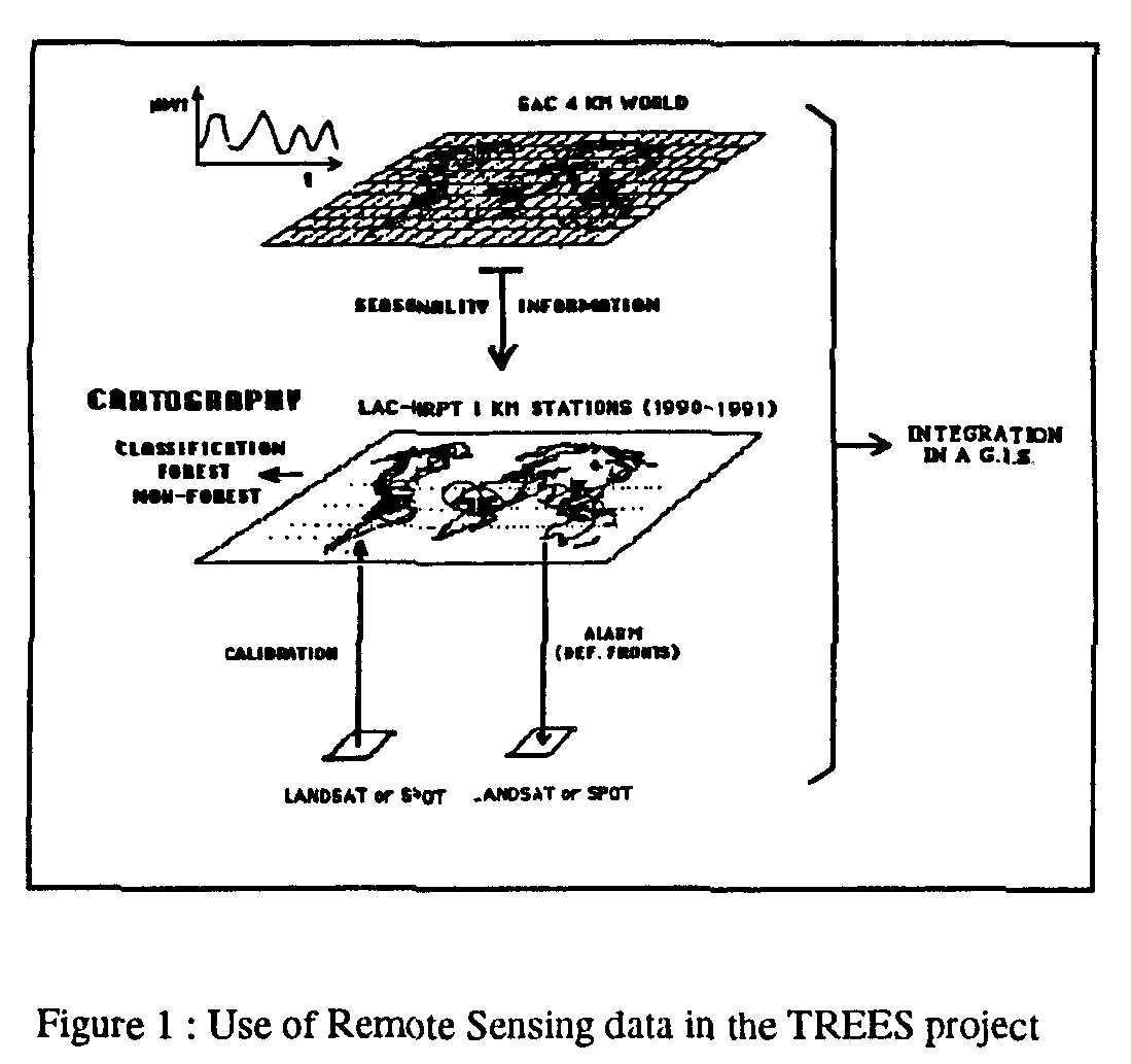
The methodology developed in the framework of the TREES project uses the AVHRR lkm products at the core of the approach. In this sense, all remote sensing work in the project is oriented towards the interpretation of the AVHRR data set in terms of forest canopy characteristics. Two additional sources of information are considered: selected high resolution Landsat TM data for validation, and low resolution AVHRR GAC data for time-series analysis and seasonality determination (Fig.1). Information derived from these two products entirely serves the lkm data set analysis. The centrality of the AVHRR HRPT (or LAC) product is justified by the fact that only such coverage is global, repetitive, at an appropriate ground resolution and in a useful spectral domain. Maintaining a uniform and coherent data base was deemed important at the outset of the undertaking. This strategy was, in addition, relying upon the recent experience in AVHRR data analysis which, as already mentioned, was found sufficient to embark upon a large scale exercise.
Three categories of tasks are considered in the overall TREES project perspective:
- the first one relates to the base line inventory of the forest surfaces. This analysis is derived from a multispectral 1 km AVHRR data set. It concerns in priority the rainforest biome and adjacent semi-seasonal formations. While the most generalised classification level contains only forest - non forest classes, other classes have been added in the regional analyses (see section 7). The classification procedure is supported by a validation/calibration exercise which is carried out using selected Landsat TM images. Attempts at identifying and mapping the seasonal character of the forest cover have also been initiated using the 10 year time series of NDVI data derived from the AVHRR GAC product.
- the second task relates to the setting up of a monitoring system. The objective is to progressively develop a continuous monitoring approach which would direct the attention to the most active land cover change - i.e. deforestation - areas. These would then be the focus of intensive and detailed observations. Grafted to this task in the concept of the so-called "alert system" (Myers, 1992).
- the third task relates to the analysis of the derived information in terms of spatio-temporal patterns of deforestation. The modelling of such determinants as population densities, resource and environment conditions and socio-economic constraints will be considered. Efforts are also initiated to make the TREES derived data available as inputs into surface-atmosphere modelling exercises.
The core of the TREES project consists of the Tropical Forest Information System (TFIS) which organises the data base (remote sensing or cartographic) and current knowledge (reports, field observations, etc.) in a systematic manner. The TFIS which is considered indispensable for management and the analysis of the vast amounts of data required is briefly described in Section 8.
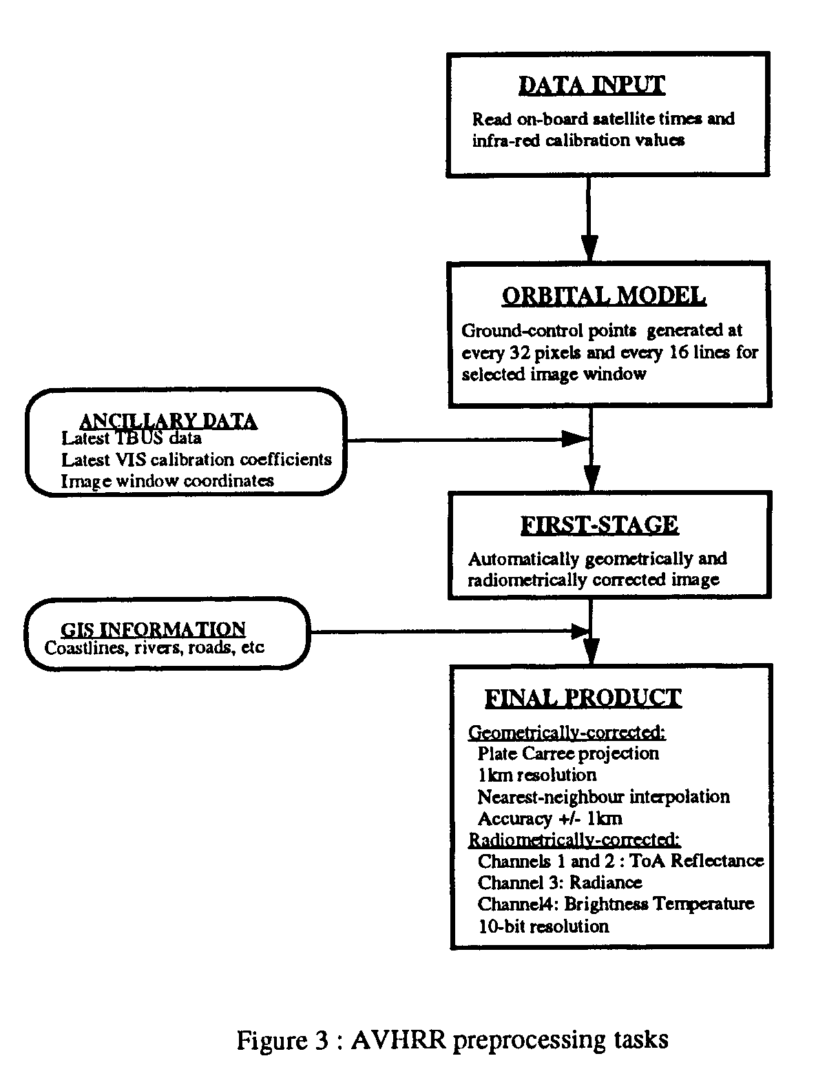
The acquisition of the so called "wall to wall" coverage of the tropical belt using AVHRR lkm data was obviously the first operation to be carried out at the outset of the TREES Project. Given the characteristics of the AVHRR data and the usually adverse meteorological conditions over the equatorial belt the data collection requirements were very stringent; they can be summarised as follows:
Region			Number of AVHRR scenes 90-93
Southeast Asia			160
Africa				150
South America				100
These data are held in the TREES raw data collection.
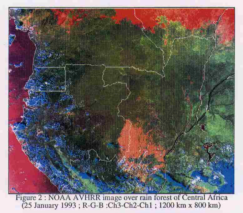
Given the large amount of satellite data available and their highly variable quality, an intensive screening process has been organised. The objective of this visual screening is to select and retain for preprocessing the orbits/acquisitions which present acceptable characteristics in terms of cloud cover, haze/smoke, angular position in the path, missing lines etc. Close to nadir passes have priority to avoid excessive distortions and strong atmospheric attenuation. Criteria related to image quality in terms of cloud/haze conditions are kept flexible and thresholds of acceptability are regionally dependent. Around the Equator itself experience has shown that the screening must try to maximise the selection of small areas of "clear" data in order to assemble image mosaics with all the retained portions. In areas with a more pronounced dry season, the search is oriented towards the selection of full acceptable orbits which will be entered in a composite image. Regional adjustments to this screening process prevent, at this stage, the automation of the procedure. The selected passes are assembled in an image catalogue (colour composites using Ch.3 red, Ch.2 green, Ch.l Blue. 1 in 4 pixel sampled data).
The preprocessing of the selected passes includes the following steps:
Each continent is divided in a series of fixed windows which are based on a broad ecological stratification. This windowing is deemed necessary to
The flowchart in Fig.3 describes the components of the preprocessing.
Elements of AVHRR image analysis can be grouped into four categories: spectral discriminators (contrasts), temporal discriminators (seasonality), spatial-textural features (patterns) and indicators of deforestation (fires, roads, etc). There is obviously no unique methodology which can be applied across the board since reflectance characteristics, spatial mosaics, atmospheric effects and seasonality introduce considerable variability across regions.
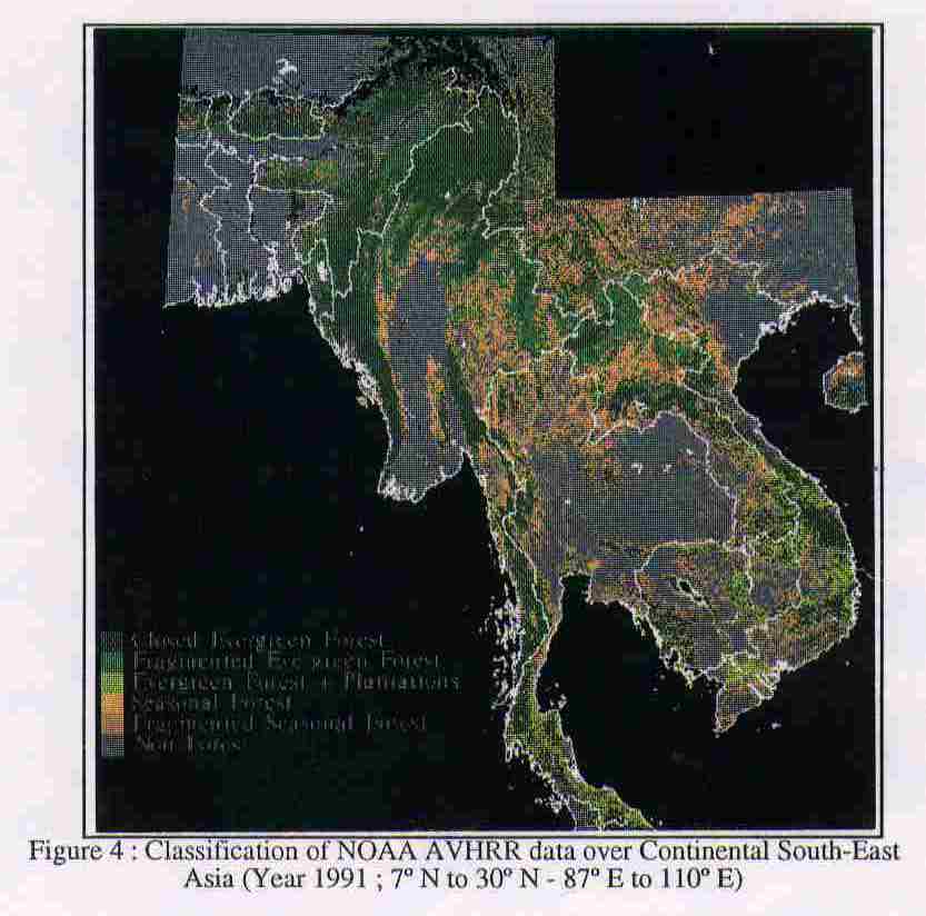
In the case of a region characterized by well marked seasonality, a good mosaic image can usually be created using selected dates and a maximum vegetation index criteria. An unsupervised classification is then applied and the clusters obtained after iteration (minimum distance criteria) are interpreted and aggregated using recent thematic maps for selected regions. This approach has been applied to Continental Southeast Asia (Fig. 4) and South America with acceptable results.
When AVHRR data are very patchy - often the case on the equator - and cover complex vegetation mosaics a progressive understanding of the spectral characteristics of the scene is obtained through an intensive analysis of the data in the available windows. In such case indeed, it is mainly the spectral characteristics of the data which represent the main element of identification (at the exclusion of other possible elements such as spatial patterns, temporal changes etc.). The transect approach has been developed to cope with such situations (Estreguil et al., 1992; Estreguil and Malingreau, 1993). Radiometric transects over portions of Sumatra have, for example, shown that contrasts between closed forest blocks and various surrounding degraded covers can be identified by using a combination of vegetation index and middle-infrared measurements. Techniques of spatial analysis are then used to emphasise such contrasts in order to better delineate difficult boundary situations. The knowledge of local spectral patterns has then been successfully incorporated into image classification. Several dates are classified and a mosaic of classifications is used to produce the final map (Estreguil and Malingreau, op.cit.).
Finally, a third approach is adopted when image quality or contrast does not allow an automatic classification. It is based upon a visual analysis of image products. Three channels of AVHRR are used to form an image composite - these are usually ch.3, 2 and 1 printed in red, green and blue. The stretching of the histogram values in the colour range is manually established so as to reveal the greatest contrast between vegetation features of interest. These are sometimes separated by very small differences in digital counts and it is crucial to attain an image product which reveals those contrasts (Malingreau et al, 1989). Individual channels are sometimes used when found more appropriate. The delineation of major vegetation formations is made on a printed image with the assistance of existing vegetation maps, high resolution images and field work. Once confirmed, the boundaries are digitised and incorporated in the TFIS. They can then be replaced over series of AVHRR images taken at different periods of time in order to further verify the position of class boundaries.
In the three cases, the result of the AVHRR data classification consist of a digitised map with an identified level of forest related information. These preliminary documents are then verified using the high resolution data sets.
A large scale land cover classification based upon AVHRR images reveals complexity in spectral classes, particularly if the AVHRR coverage is composed of several single images. The reflectance characteristics of different forest types, the variable spectral response of seasonal forests, degradation and fragmentation are responsible for variations in the signal. Different atmospheric conditions, topographic effect and bi-directional reflectance also influence image characteristics.
The objective of the validation procedure is twofold:
- validate the interpretation of the AVHRR data in terms of vegetation classification; given the low resolution of this data set and the possible strong seasonality effect upon the interpretation, confirmation of the class assignment is sometimes necessary. This is done by visual comparison.
- calibrate the AVHRR measurement. It is well known that analyses based upon the 1 km resolution can over- or underestimate forest cover depending upon the local pattern of forest - non forest interface (fragmentation). Biases in AVHRR measurements have been recognised for example in studies over the Amazon basin where deforestation is overestimated as in the case of Rondonia (fishbone pattern) (Cross, 1991). Deforestation can also be underestimated using AVHRR data when the forested area is large and openings are small and distributed without a clear geometric pattern (i.e. shifting cultivation - Stibig, 1993).
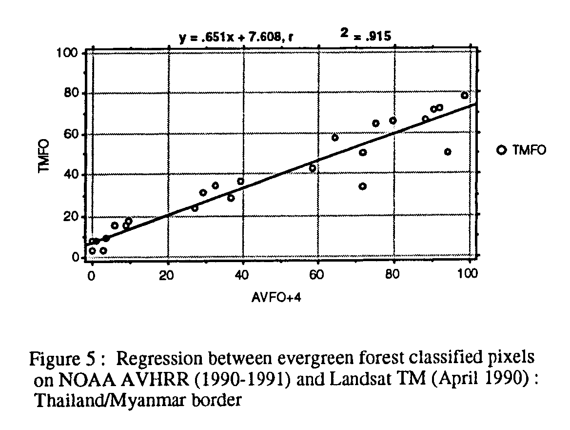
The validation process relies on the important assumption that the "truth" is represented by the information derived from the high resolution data (in this case Landsat TM). The extensive field work carried out by regional specialists is undertaken in support to the TM analysis and never directly linked to the AVHRR data themselves. A major difficulty which must be mentioned in this respect is that correct vegetation classification is difficult on mono-temporal high resolution data sets. The acquisition of seasonal Landsat TM data sets is, however, very cumbersome and in all cases very costly. In an exploratory phase the acquisition of high resolution data sets covering as wide as possible a range of forest-non forest interfaces was given priority. The selection of the sample images has, therefore, been purposive by regional coverage and availability (18 Landsat TM images for Asia, 7 for Africa and 40 for Sth America have so far been selected). The subsampling procedure is based upon a systematic positioning of l5 x l5km measurement units (Secondary Sampling Units) across the Landsat images. Regression is then calculated on the basis of the classified TM and AVHRR pixels in 25 secondary sampling units per Landsat frame. An example of those results over evergreen forest is given in Fig. 5 (Stibig, 93). Equal area estimates are in this case found for the 20-30% forest cover situation; for lower cover percentage the AVHRR underestimates the "true cover"; for more dense cover, AVHRR overestimates the actual percentage. These regressions which are systematically established for different forest types and fragmentation patterns are then used for correcting the AVHRR forest area calculation. Other sampling approaches will be tested (Kleinn et al. 1993). The role of microwave data (ERS-l) in this validation perspective is currently being examined (Leysen et al. 93).
Seasonal changes in the radiometric characteristics of the forest canopy are at the same time a source of information on vegetation types and a source of error in image analysis. The difficulties encountered in the use of single date high resolution images have been referred to in the previous Section. The TREES project is introducing a seasonal characteristic in the vegetation classification through the systematic use of temporal data. In the first place, the AVHRR lkm data set used in the classification is always composed of at least three dates (early, mid- and late dry season): radiometric changes associated with the progression of the dry season lead to the identification of the seasonal character of the formation. Second, longer time series of vegetation index data derived from the AVHRR 10 year GAC data set are progressively introduced in the classification process. Problems of associating long time series information at low resolution (usually, 6-8 km) with more detailed classification derived from a very short time series and at the higher 1 km resolution level are yet to be solved.
The overall problem of vegetation classification at the scale considered by the TREES project also requires further attention. Indeed, if it is accepted that satellite imagery is the major source of information for global mapping of vegetation, classification schemes must be developed which at the same time satisfy the need for information by foresters, ecologists, climate modellers etc. and the capabilities of the observation/mapping technology. The TREES project contributes to the discussions on this topic thorough the UNEP/WCMC/GCTE Working Group on Vegetation Classification (Malingreau and Achard, 1993). Currently, the classes retained in the analysis relate to dense evergreen forest, dense seasonal forest, fragmented forest canopy (evergreen and seasonal), non forest cover. Subclasses are regionally determined; they include other non forest classes (i.e. mixed forest-savanna class in Africa, or identifiable seasonal forest classes such as mixed seasonal and dipterocarp forests).
A coherent geographical information system has been developed in the framework of the TREES project with the following criteria in mind (D'Souza et al. 1993):
The data types held in the TFIS are:
The TREES Project has demonstrated that the AVHRR 1 km data can provide the material for carrying a base line assessment of tropical forest cover. The approach is based upon an intensive data collection exercise and the development of regionally-tuned classification techniques. The support of high resolution data is considered indispensable in the framework of the so-called validation and calibration exercise. Comparison of TREES classification with reliable published forest cover maps show that a level of congruence is usually obtained for the closed evergreen forest, the closed seasonal forests and for those forested areas presenting low fragmentation levels. Discrepancies between results obtained from various sources are linked, among others, to the ever present problems of vegetation classification. An intensification of the joint use of low and high resolution data sets as well as the systematic conduct of the classification using the full power of the Tropical Forest Information System will further increase the accuracy and the level of confidence in the final results.
The lessons learned from this first TREES project have led the Joint Research Centre to propose a second phase called TREES II (1994-1998). This project will be geared to the development of a prototype operational tropical forest monitoring system. The plan calls for a better streamlining of all the remote sensing operations, for the full utilisation of the TFIS in the classification process and for the incorporation of a variety of non-remote sensing data sources in the analysis. Improved linkages with well identified users of tropical forest data will be organised. At this stage, it is expected that the series of AVHRR instruments will remain the prime provider of data for this global forest monitoring exercise.
Cross, A., 1991, Tropical forest monitoring using AVHRR: towards an automated system for change detection. UNEP-GRID Geneva, 44 p.
D'Souza, G. and J.P. Malingreau. 1993. NOAA-AVHRR studies of vegetation characteristics and deforestation mapping in the Amazon Basin. Submitted to Remote Sensing Reviews.
D'Souza, J.C., Stuttard, M. and P. Byrne. 1993. GIS design issues in setting up a tropical forest information system (TFIS) for the TREES Project. Proceedings of EGIS 93. March 29 - April 1, 1993. Genoa. Italy.
Estreguil, C., Malingreau, J.P. and F. Achard. 1992. Spectral Contrasts associated with forest types in tropical areas as seen on AVHRR data. IGARSS Houston 1992.
Estreguil, C. and J.P. Malingreau. 1993. Vegetation characteristics and land cover mapping with NOAA AVHRR data in the humid wet tropics. Submitted to GeoCartoInternational.
FAO, 1991, Forest Resources Assessment Project. Forestry Project Profile ndeg.7, Rome.
Kleinn, C., Dees, M. and D.R. Pelz. 1993. Sampling aspects in the TREES Project - Global inventory of tropical forests. Final Report. Abteilung Forstlische Biometrie, Univ. Freiburg. Joint Research Centre. Ispra. 36 p. + annex.
Leysen, M., J.A. Conway and A.J. Sieber. 1993. A case study comparing multitemporal ERS-1 SAR data and Spot data for tropical forest mapping. SPOT-ERS-1 Conference. CNES and ESA. Paris.
Malingreau J.P and F. Achard. 1993. Towards an improved vegetation classification scheme for global vegetation monitoring. Taking into account the contribution of remote sensing. Presentation at the UNEP/HEM/WCMC/GCTE Workshop on "Improved Vegetation Classification Scheme for Global Mapping and Monitoring." Charlottesville, USA. 24-26 Jan.1993.
Malingreau, J.P., R. DaCunha and C. Justice, Eds. 1992. World Forest Watch Conference Proceedings. Joint Research Centre, Ispra. EUR 14561 EN. 84 p.
Malingreau J.P., C.J. Tucker and N. Laporte. 1989. AVHRR for monitoring global tropical deforestation. Int. J. of Remote Sensing, 10, 855-68.
Myers, N. 1992. Future operational monitoring of tropical forests: an alert strategy. in: J.P Malingreau et al. Eds. World Forest Watch Conference Proceedings. Joint Research Centre. Ispra. EUR 14561.EN. pp.9-140
Stibig, H.J. 1993. Global Tropical Deforestation (Monitoring) Using satellite Observation Techniques. Report. Signum - Gesellschaft fur Digitale Satellitenbildverarbeitung. Joint Research Centre. Ispra. 46 p.+Appendix
TREES, l991, TREES Strategy Proposal 1991-93, Part l: AVHRR data collection and analysis, CEC-JRC publication EUR 14026 EN, Ispra, Italy, 20p.