 Reproduced, with permission, from:
U.S. Congress, Office of Technology Assessment. 1993. The future of remote sensing from space: Civilian satellite systems and applications. OTA-ISC-558. Washington, D.C.: Government Printing Office.
Reproduced, with permission, from:
U.S. Congress, Office of Technology Assessment. 1993. The future of remote sensing from space: Civilian satellite systems and applications. OTA-ISC-558. Washington, D.C.: Government Printing Office.
Many variables determine weather. For example, atmospheric pressure, temperature, and humidity at different altitudes affect the development and progress of storm systems, the amount of precipitation a region receives, and the number of cloudy days. Over time, these factors contribute to the climate on local, regional, and global scales. Throughout the day, sensors located on the land and oceans and in the atmosphere and space:
Data gathered by these sensors are essential to understanding weather and climate. Despite efforts to date, large gaps still exist in scientists' understanding of the detailed mechanisms of weather and climate and in their ability to predict how weather and climate will change. Climatologists would like more data on atmospheric chemistry and dynamics, the extent of clouds, winds at the oceans' surfaces, and upper atmosphere winds. As the recent concern over the degradation of Earth's protective ozone layer demonstrates, human activities alter atmospheric chemical constituents and affect the structure and health of the atmosphere. By closing these data gaps, scientists hope to understand the forces that affect Earth's weather and determine its climate. They also hope to differentiate natural variability from anthropogenic changes in weather and climate.
Satellite sensors offer wide, repeatable coverage, long-term service, and the ability to monitor several aspects of weather and climate simultaneously. Data from satellites contribute to both short- and long-term weather prediction and modeling and enhance public safety. In the short run, images of weather systems, obtained primarily from satellites in geosynchronous orbit, allow forecasters to predict the probable paths of severe storms. Data collected by polar orbiting satellites concerning the atmosphere, land, and oceans, are invaluable for understanding and modeling atmospheric temperature, humidity, wind, and the extent and condition of global vegetation (plate 3).
As noted earlier, NOAA operates two satellite systems to gather data concerning weather and climate in order to support the national economy and promote public safety.
To provide complete U.S. coverage, NOAA normally maintains two GOES satellites in orbit (box 3-A). However, difficulties experienced in constructing the next series of GOES satellites, GOES-Next, and the lack of a backup for the current series, have left the United States dependent on a single satellite, GOES-7, the last in the current series. To maintain critical weather observations over the United States, NOAA has signed an agreement with ESA and Eumetsat (box 3-B), the European Organisation for the Exploitation of Meteorological Satellites,[1] to lend the United States Meteosat-3 to supplement observations from GOES-7 and to stand in should GOES-7 fail (figure 3-1). This arrangement illustrates the high level of international cooperation in meteorological remote sensing, which is carried out in other areas as well. Because weather patterns move across national boundaries, international cooperation has been an important component in the collection of weather data. Governments need to cooperate with each other in order to follow weather patterns that transcend national boundaries.
GOES-7 is currently operating well, but it and Meteosat-3 are about one year past their design lives. The first satellite in the series of GOES Next satellites is scheduled for launch in spring 1994 (figure 3-2). The follow-on GOES-Next satellite has been plagued by technical and programmatic setbacks that, until the summer of 1992, led to major schedule slips and large cost overruns. Changes in management have resulted in controlled costs and good schedule success. However, until GOES-Next has been successfully launched and placed in operation, the United States faces the risk of losing weather information now provided by geosynchronous satellites.
During the early 1980s, in an effort to improve the satellite data available to the National Weather Service, NOAA funded and NASA developed new, more complex sensor and satellite designs for the GOES series. NOAA termed the new satellite series GOES-Next. GOES-Next will retain the existing visible imaging but also will provide higher resolution infrared imagery to enhance the prediction and monitoring of severe weather. A separate, continuously operating improved atmospheric sounder[2] should allow for uninterrupted data on the atmosphere, contributing to improved storm prediction.
NOAA and NASA have a history of more than 30 years of cooperation on environmental satellites. NASA developed the first TIROS polar orbiting satellite in 1960, and in 1974 it launched SMS-GOES, the precursor to NOAA's GOES system. Generally NOAA has relied on NASA to fund and develop new sensors, several of which NOAA adopted for its environmental satellites. A 1973 agreement between NASA and NOAA resulted in the Operational Satellite Improvement Program (OSIP) within NASA, which provided funding at the rate of some $15 million per year to support development of new sensors and other technologies to improve NOAA's operational satellites. In the 1970s, highly successful cooperation between NASA and NOAA resulted in the development of several sensors, including the Advanced Very High Resolution Radiometer (AVHRR) and the Total Ozone Mapping Spectrometer (TOMS).[3] During the early 1980s, in an attempt to cut its spending on satellite development, NASA eliminated spending on OSIP, leaving NOAA to fund development of GOESNext, using NASA as the procurement agency. Problems with program management, unexpected technological challenges, and overly optimistic bids accepted from contractors have caused the development of GOES-Next to exceed its original estimated costs by over 150 percent (box 3-C).[4] If Congress wishes NASA to continue to engage in research and development for NOAA's operational sensors and satellites, it could direct NASA to reinstate the OSIP budget line for sensor development and provide sufficient funds to support OSIP. In addition, Congress could direct NASA and NOAA to develop a more effective relationship for the development of new operational systems. Alternatively, Congress could fund NOAA sufficiently to allow NOAA to develop its own advanced sensors. However, the latter option would require that NOAA develop sufficient expertise in satellite design and development to manage new development projects, which would likely cost more than directing NASA to take on the task again.
The POES program (box 3-D), like the GOES program, employs a two-satellite system. One polar orbiter repeatedly crosses the equator at approximately 7:30 am local standard time (the "morning" orbiter) and the other satellite crosses the equator at approximately 1:30 pm (the "afternoon" orbiter). Although NOAA's funding for the POES system has been highly constrained by tight NOAA budgets and by cost overruns of the GOES program, NOAA has nevertheless managed to keep two operating satellites in orbit at all times.[5] At the same time, it has actively sought international cooperation as a means of spreading the burden for providing important information to all countries of the world, and as a means of reducing U.S. costs.
For the future, NOAA is considering incorporating several of the instruments NASA has under development for the Earth Observing System in its operational satellites. For example, the Atmospheric Infrared Sounder (AIRS), planned as a high-resolution instrument that will provide temperature and humidity profiles through clouds, would be a candidate for use on future NOAA satellites.[6] However, NOAA will have to gain extensive experience with the NASA instruments and the data they provide in order to transfer them to operational use. NASA will also have to take into account the instrumental characteristics necessary for developing an operational sensor. NOAA is also investigating other new instruments to improve the quality of its POES data collection.[7] Over the years, NOAA has established an enormous base of international data "customers" who depend on the delivery of data of consistent standards and familiar formats. It therefore carefully considers any changes to the format and eschews technical or financial risks to its operations.
The United States historically has transmitted data from the polar metsats at no cost to thousands of U.S. and international users, who collect data using inexpensive Automatic Picture Transmission (APT) recorders or High Resolution Picture Transmission (HRPT) recorders as the satellite passes over. Some 120 governments and thousands of other users around the world benefit from this service.[8] In return, through the World Meteorological Organization,[9] many of these users provide the United States with local ground-based and radiosonde[10] data, which are essential to understanding large-scale weather patterns and climate. Some countries contribute directly to U.S. programs by supplying satellite instruments. Over the last few years, France has supplied the ARGOS onboard data collection receiver, and, with Canada, the SARSAT location system for the POES satellites; the United Kingdom has supplied the SSU.
Negotiations are currently underway between NOAA, representing the United States, and ESA and Eumetsat for Europe to assume responsibility for morning-crossing operational meteorological data on the European METOP polar platform. Originally, Europe had planned to fly a large polar orbiting platform called POEM (Polar Orbit Earth Observation Mission), planned for launch in 1998. It would have included both research instruments and operational monitoring instruments. However, in order to reduce technical and financial risk, ESA and Eumetsat decided in late 1992 to split up the platform and place the operational and climate monitoring instruments on the Eumetsat METOP platform and the upper atmosphere, ocean, and ice research instruments on the ENVISAT platform.[11] The United States will also fly an improved AVHRR and an Advanced Microwave Sounding Unit (AMSU) on METOP-l, which is planned for launch in 2000. This will reduce U.S. costs of providing data from the second polar orbiter, which is an important first step in saving U.S. costs for the entire polar satellite system. It may also enable the United States and Europe to provide more accurate coverage of weather and climate.
In the early part of the next century, Europe plans to provide nearly half of the polar-orbiter program. NOAA expects the cooperative polar metsat program to lead to nearly identical U.S. and European instruments, spacecraft, instrument interfaces, standard communication procedures, and data transmission standards. This is essential to reduce problems of integrating instruments and to assure that international partners can use each other's data with a minimum of complication.
The program will include some moderate enhancement of instrument capabilities and the addition of a TOMS to maintain the capability to monitor atmospheric ozone.
This cooperative structure should enable the United States and Europe to supply polar orbiter data to the rest of the world. Eventually the two partners might wish to embark on a broader cooperative effort including other countries, which would reduce U.S. and European costs and give greater likelihood to a widely accepted international data standard. For example, Russia operates a polar-orbiting meteorological satellite, Meteor-3, which already carries a TOMS instrument supplied by NOAA. Both the United States and Russia would likely benefit from closer cooperation on Earth observation satellite systems.
A more broadly based organization, including for example, Russia, China, and India, could also lead to a more capable system of polar orbiters. As noted earlier, the United States and other spacefaring nations have organized the Committee on Earth Observations from Space (CEOS) in order to encourage development of complementary and compatible Earth observation systems (and data), and to address issues of common interest across the spectrum of Earth observation satellite missions.[12] Chapter 8, International Cooperation and Competition, discusses these and other cooperative arrangements in more detail.
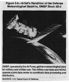
DoD maintains an independent meteorological system, the Defense Meteorological Satellite Program (DMSP), managed by the Air Force Space Command (box 3-E). DMSP (figure 3-3) uses a satellite platform very similar to the NOAA POES platform and operates in near-polar orbit, but carries somewhat different instruments. Among other data, DMSP provides visible and infrared ground images, measurements of soil and atmospheric temperature and moisture content, location and intensity of aurora (for radar and communications), and measurements of sea state and wind fields for naval operations. The military also uses three-dimensional cloud data from DMSP in computer models used in operational planning. The phenomena observed by DMSP are similar to those of interest to civilian weather forecasters, but several of the data requirements, such as wind speed at the oceans' surface, are of crucial interest to the military.
Are two polar-orbiting satellite systems required? Critics of the policy of maintaining separate polar-orbiting systems argue that the United States cannot afford both systems.[13] DoD and NOAA counter that each satellite system serves a unique mission. The NOAA satellites routinely provide data to thousands of U.S. and international users. DMSP serves a variety of specialized military needs and provides valuable microwave data to the civilian community. For example, often the United States has troops involved in exercises or stationed in remote locations that would not have other sources of weather information. DoD and NOAA regularly exchange meteorological data. NOAA benefits from DMSP data, and DoD also routinely uses data from NOAA. Yet DoD's needs for both training and operations can be unique. DoD requires a reliable source for global weather forecasting, a function it argues is not duplicated within NOAA. Military analysts fear that civilian satellite systems, which are not under DoD control, would be unable to deliver crucial weather information to their users in time. DoD also wants to have a domestic data source insulated from international politics because data from another country's satellites might not always be made available. Finally, differences in the priorities of instruments result in differing replacement criteria for satellites when an instrument fails. For NOAA the sounder on its POES has the greatest priority. The DMSP imager holds the highest priority for the DoD. For these reasons, DoD claims a distinct need for its own meteorological system.
Congress may wish to revisit the question of the possible consolidation of DMSP and the NOAA polar orbiting system as it searches for ways to reduce the Federal deficit. Such a study should include a detailed analysis of the benefits and drawbacks of consolidating civilian and military sensor packages in one system, and the ability of a combined system to serve military needs in time of crisis. It should also look for innovative ways for NOAA and DoD to continue to work in partnership to carry out the missions of both agencies.
The first European Meteosat satellite was launched by ESA in 1977. Eumetsat took over overall responsibility for the Meteosat system from ESA in January 1987. The first spacecraft of the Meteosat Operational Programme (MOP-l) was launched in March 1989. MOP-3 is now being prepared for launch in late 1993. It has a 7-year design life. ESA has developed the MOP satellites on behalf of Eumetsat.
The Meteosat/MOP spacecraft design, instrumentation, and operation are similar to the current U.S. NOAA GOES spacecraft. The spin-stabilized spacecraft carry:
Meteosat spacecraft are in position to survey the whole of Europe, as well as Africa, the Middle East, and the Atlantic Ocean. They relay images and data to a Meteosat Operations Control Centre within ESA' s Space Operations Control Centre in Darmstadt, Germany. A Meteorological Information Extraction Centre, located within the Meteosat control center, distributes the satellite data to various users.
The Japanese space agency, NASDA, developed the Geostationary Meteorological Satellites 1-4, which were launched in 1977, 1981, 1984, and 1989. GMS-5 is projected for a 1995 launch. [14] The GMS satellites are manufactured by Hughes Space and Communications Group and the Japanese corporation NEC, and draw heavily on Hughes' U.S. experiences with GOES. The Japan Meteorological Agency operates the third and fourth satellites, collecting data from the systems' radiometers (visible and infrared sensors), and space environment monitors.
The former Soviet Union assembled an integrated network of meteorological, land, and ocean sensing systems that have served a wide variety of military and civilian purposes. Now essentially controlled by the Russian Republic, these satellites represent one of the most capable array of remote sensing systems deployed in the world. The CIS operates eight different space platforms (including the Mir space station) that provide remotely sensed data.[15]
The CIS Meteor environmental satellite system consists of two or more polar orbiters, each of which lasts only a relatively short time in orbit. Each Meteor satellite provides data roughly similar to the NOAA POES satellites. Meteor satellites carry both visible-light and infrared radiometers, and an instrument for monitoring the flux of high energy radiation from space. Data from these instruments lead to information about the global distribution of clouds and snow and ice cover, global radiation temperature of the surface, cloud-top heights, and vertical distribution of temperature. The data can be received around the world by the same APT stations that receive data from the U.S. polar orbiters.
11 The minutes of the ESA Ministerium of November, 1992, state:
(1) the Envisat-1 mission planned for launch in 1998, which will be mainly dedicated to understanding and monitoring the environment and to providing radar data as a continuation of the data provided by ERS 2.(2) the Metop-1 mission planned for launch in 2000, which will provide operational meteorological observations to be carried out taking into account the requirements expressed by the Eumetsat Council and in accordance with the terms of an Agreement to be concluded with Eumetsat.