 Reproduced, with permission, from:
Thomas, M., and N. Roller. 1993. CIESIN's experiences with integrated global change research. In Proceedings of the 25th International Symposium on Remote Sensing and Global Environmental Change, 294-305. Vol. 2. Ann Arbor, MI: Environmental Research Institute of Michigan.
Reproduced, with permission, from:
Thomas, M., and N. Roller. 1993. CIESIN's experiences with integrated global change research. In Proceedings of the 25th International Symposium on Remote Sensing and Global Environmental Change, 294-305. Vol. 2. Ann Arbor, MI: Environmental Research Institute of Michigan.M. Thomas and N. Roller
Consortium for International Earth Science Information Network
University Center, Michigan U.S.A.
Global change is a subject that must be studied in an integrated manner, involving both the natural and human sciences. In 1991 CIESIN sponsored eight such integrated global change research pilot projects. Collectively, these projects provided insights into the generic process and attributes of effective integrated global change research.
Natural scientists have traditionally approached global change research by developing models of physical processes at large scales, and building data bases to exercise them. The pilot projects suggests that there are few comparable global process models in the human sciences. This observation has implications in terms of the types of data sets that must be made available for global change research and the need to develop additional models.
The pilot projects also revealed the value of remote sensing data in integrating global change research. Satellite images were used to facilitate communications, establish joint human-natural science strata, identify of important changes, and design of data collection procedures to learn more about the causes of the changes. Conceptual, graphical, statistical, and image- and geographically-based techniques were used integrating natural science, human science, and remote sensing data.
Scientific findings indicate that changes to the global environment may be occurring at an unprecedented rate, affecting not only the plants and animals that share life on Earth with us, but the quality of human lives as well. Until recently, global environmental change research focused primarily on understanding physical processes behind such phenomena as climate change and ozone depletion. We now appreciate that a clearer understanding of the interrelationships of physical and social factors involved in such phenomena is also urgently needed by researchers, policy makers, and the world's people as they seek solutions for sustainable development of the Earth's resources.
Understanding the complex issues associated with global change phenomena will require forging strong interdisciplinary links between the natural and human sciences, as well as providing needed information to the policy makers of all nations who must confront environmental and social issues. These activities must begin with sharing of information and knowledge that transcends political and cultural boundaries, and with mechanisms for sharing global change information throughout the world. To this end, the Consortium for International Earth Science Information Network (CIESIN) is helping to build and maintain information gateways for accessing, integrating, analyzing, disseminating, and exploring data on global environmental change.
The purpose of this paper is to review and discuss results of CIESIN's Pilot Project Program, one of a number of recent efforts towards fostering the integration of natural and human science global change research. This program was conceived by CIESIN as a mechanism for providing an initial demonstration of many of the concepts involved in its mission. The program consisted of nine pilot projects. While each project had its own specific study objectives, it was intended that, taken together, they would help provide the broad base of experience required to develop some of the insights and experience CIESIN needs to accomplish its mission.
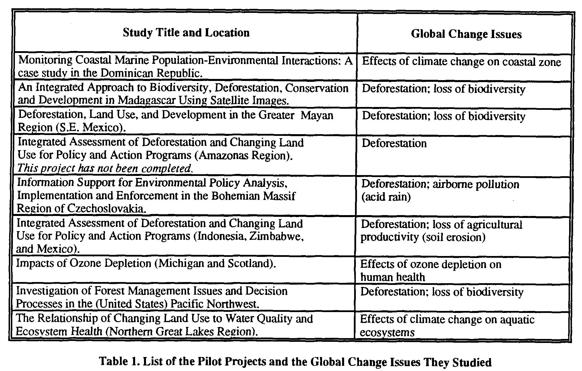
The CIESIN Pilot Project Program was initiated with a request for proposals in August 1990. Following an independent review of the proposals that were received, CIESIN selected nine proposals for funding in late December 1990. The performance period of the projects was January through December of 1991. A list of the titles of selected projects and the global change issues investigated is presented below in Table 1.
3.1 Scope of the Projects and Relationships Between Projects
The pilot projects investigated topics related to several important global change issues, including deforestation, loss of biodiversity, climate change, airborne pollution, ozone depletion, and loss of agricultural productivity (See Table 1). Each of the individual pilot projects followed the strategy of studying global change by examining its regional or local manifestations or causes. All projects were initiated with the aim of conducting interdisciplinary research into the human dimensions of an important global change issue, and involving the use of both human science and natural science data.
The specific objectives of the science pilot project program were to (1) begin to identify the data and information needs of interdisciplinary global change research, emphasizing the "human dimensions" of these needs; (2) explore the issues associated with integrating natural science, human science, and remote sensing data; and (3) demonstrate the feasibility of managing, evaluating, and transferring knowledge generated by global change research to a variety of users to support decision-making and policy formulation.
With respect to the first objective, CIESIN viewed the pilot projects as an early opportunity to identify many of the generic categories, as well as specific types, of data, information, and models required for human dimensions analyses of global change issues. Specifically, CIESIN hoped to gain an appreciation for the variety of data and information formats that must be accommodated, so it could "scope and dimension" its operational functions and capabilities. CIESIN also wanted to understand the problems the pilot project investigators encountered in the process of locating and accessing the data and information they needed, particularly human science data.
Secondly, CIESIN intended for the pilot projects to explore the largely uncharted process of interdisciplinary global change research, emphasizing the human dimensions of the process. Specifically, CIESIN hoped to become familiar with the process of "interdisciplinary research" by sponsoring a "sample" of what it considered to be typical global change research studies and then closely monitoring and observing what occurred. From these observations, it was expected that CIESIN would learn about the various problems associated with data location and access, data integration, data analysis, and producing user relevant information that researchers need help in overcoming.
Finally, CIESIN intended to extract from what it observed that which would provide guidance for its organizational and operational development. More specifically, it was expected that information would be obtained about: (1) how to satisfy policy makers' needs for information, (2) the products and services required to satisfy these user needs, (3) the functionality required of the CIESIN Global Environmental Information System for producing these products and services, (4) methods of effectively transferring the knowledge generated by research to users, and (5) methods of encouraging cooperation among researchers and synergy in their research.
3.2 The Global Change Research Process
Review of the pilot projects indicates that there may be some very significant differences between the way human science and natural science global change research is currently implemented. Natural scientists have traditionally approached global change research by developing models of physical processes at large (e.g., regional and global) scales, and building data bases to exercise them. Evidence from the pilot projects suggests that there are few comparable global process models in the human sciences. This may be partly due to the lack of perceived direct connection between individual humans on a global scale, compared to, for example, climate models, in which even small interactions involving energy provide a common link between processes at different scales.
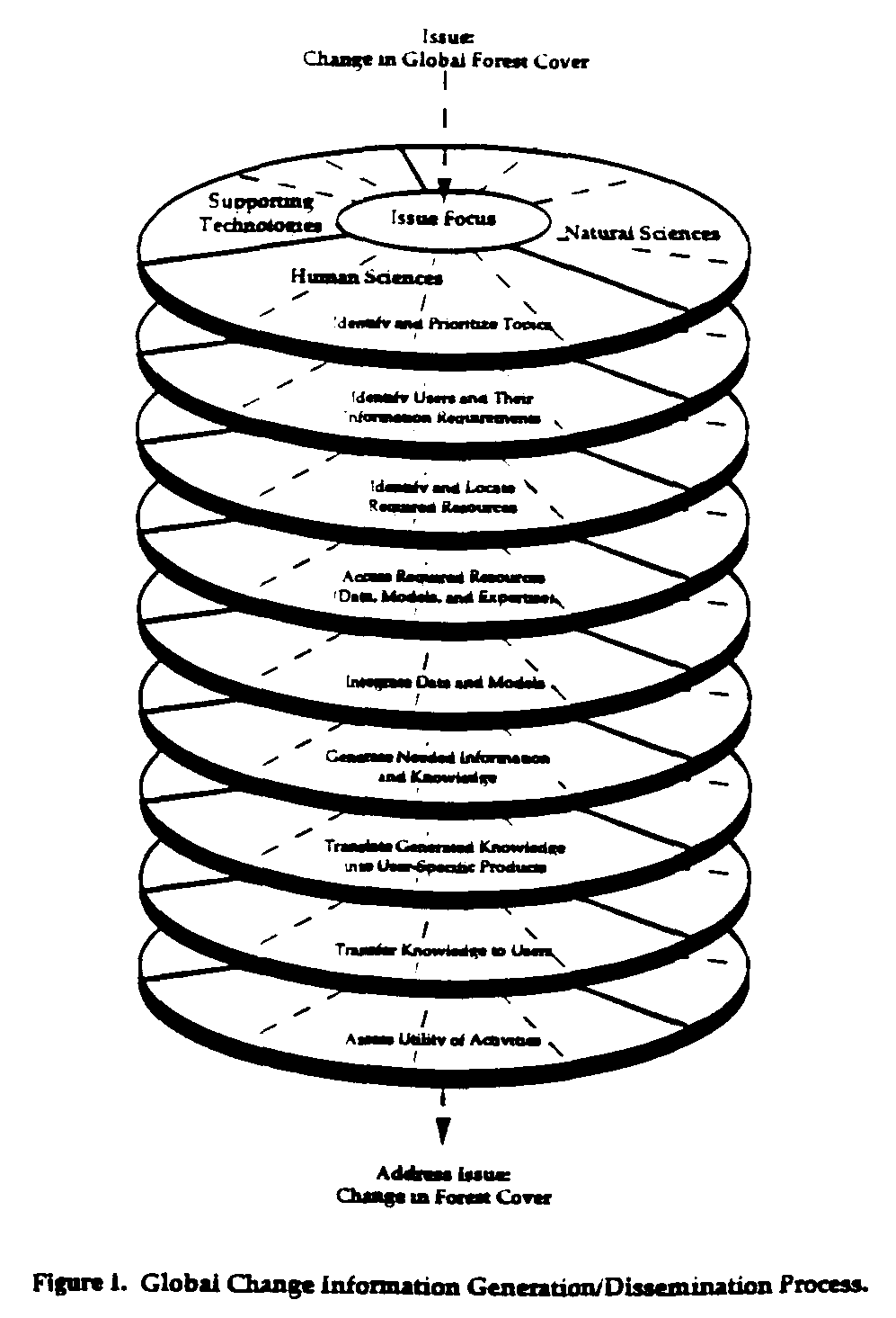
One of the most important results of the pilot projects was that they collectively illustrated that the process of doing global change research consists of a set of generic, inter-related activities (Figure 1). It was possible to observe the importance of the need to include all of the generic component activities of the process in each research project by comparing the relative success of each investigator with respect to whether or not they included all of them in their project. Results suggest that, in general, the essential, generic component activities that make up the process of effective integrated, interdisciplinary global change research include: (1) identification of user needs; (2) location and accessing of desired data; (3) producing the desired information from the data; and, (4 translating and transferring the desired information. These activities, as part of a process that is continuous, have indistinct boundaries, but discussing them as if they are separate steps is useful for examining what is involved in each activity, the global change research process as a whole, and in organizing a discussion of the entire process.
3.2.1 Identify User Needs
The pilot projects provided significant information on the types of data useful to researchers trying to meet the needs of decision makers. Even though the issues that are being studied in global change research are of worldwide importance, the methods that are currently being used to study their human dimensions typically rely on assembling compatible local or regional data sets. For these data sets to be effective on a global scale, however, data collection plans must include the needs of human dimensions global change research. Criteria for identifying essential data resources that researchers use in selecting which issues to study should be policy driven, and therefore issue oriented. An issue-oriented focus will, in turn, determine the specific data variables to which access must be facilitated, and suggest the data sets that are actually relevant (e.g., population statistics for "District A" for 1970, 1980, 1990), which are a function of geographic region, the time interval of interest, and other factors.
3.2.2 Locate and Access Required Data
Acquiring the desired data requires both locating the data and accessing the data. Locating the data involves searching for, and identifying a repository of, the desired information. Accessing the data may require solving a myriad of technical, political, and bureaucratic problems. If the data do not exist, then the investigator must develop and carry out a plan to collect the missing data.
A primary finding was that a significant amount of the data desired were not available from well-known archives. The significance of this finding is that (1) simply linking well-known data archives will not in itself provide access to all the data desired by users; and (2) data location is a very difficult task that may require a level of familiarity with issues and geographic regions that will find difficult to achieve. Some of the desired data were not easy to access even after it was located, due to logistical issues, the format of the data, and other factors. Another important finding was that a significant amount of the human science data needed by the investigators, such as information on attitudes and perceptions, and cultural constraints, did not exist, and had to be generated.
It is also worth noting that much of the previously existing data actually used in the pilot projects, especially the human science data, was not originally in digital form. Rather, it was in the form of maps or tables. Much of the human science data generated by the investigators were in the form of responses to questions in surveys that were summarized in narrative text. Development of a capability to access, store, and distribute such data must take these characteristics into account.
3.2.3 Produce Information
Producing the desired information is where the "science" in the global change research process is really done. It involves integrating and analyzing data using a variety of procedures to produce knowledge.
In order to make optimal use of multi-source global change data, effective integration methodologies must be developed. Integration methodologies should govern the collection of new data, as well as the analysis of existing data. Integration of data at the point of collection is the result of a well-thought-out plan, in which the types of data to be collected are specified and designed to be complimentary and the location and timing of their collection are coordinated. This type of integrated data collection plan can coordinate the acquisition of data within a single project, or between projects. The Pacific Northwest project was noteworthy for demonstrating a within-project integration plan to collect relevant human science, natural science, and remote sensing data over the same geographic area and time to assess the human and physical causes of changes in the forest and their effects on humans and the environment.
Another noteworthy example of integrated data collection comes from the Madagascar pilot project. In this project there were efforts of human and physical scientists to collect jointly useful data at the same place and time. The participants in this project found this type of planning and coordination to be difficult, but ultimately their results were more rewarding than a non-integrated effort. In many developing countries, maps are not available or are seriously outdated. Current satellite remote sensing was used to update maps and plan data collection activities in Mexico, Madagascar, Zimbabwe, and Indonesia.
The difficulty of achieving meaningful integration of already existing data was also demonstrated. Some projects found that existing data could not be meaningfully integrated (e.g., Mexico), due to various differences in the way the variables were originally defined and subsequently collected. Some investigators found that even the data they generated themselves could not be meaningfully integrated and compared with other data for assessing change (e.g., Madagascar). These findings demonstrated that, unless data is accessed or collected according to a data integration plan, subsequent data integration may not be possible or meaningful.
3.3 Building Comparable Global Change Process Models
Effective global change research should consider the acquisition and/or development of global human science models and associated data. To become truly global in scope, human process models need to focus beyond the traditional local and regional studies but, at the same time, the reason that global human science data is used only as a context for the local study, if at all. For the near-term, this finding means that providing access to local and regional human science data will be proportionately more important than providing access to global data sets, except for context development.
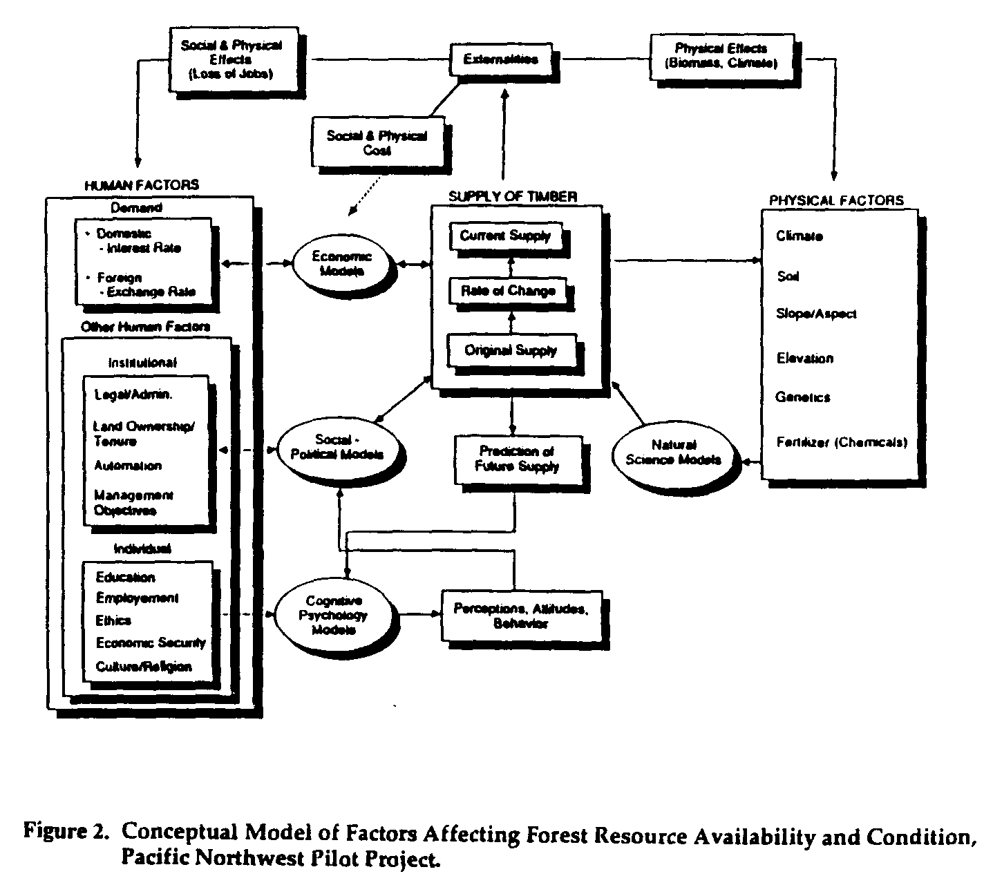
Exceptions to the above observations should be noted. For example, it may be that global market economic models provide a means for relating local and regional human processes to global processes through the impacts of these processes on global markets. As an example, the CINTRAFOR model developed at the University of Washington connects the price of forest products in the Pacific Northwest with forest products elsewhere in the world (e.g., Japan) through a global economic model which describes the flow of global forest products. In this case, price, demand and supply are all human dimensions components that operate at both local and global scales, and thus can be used to relate local human processes to global human processes. This type of model could be used to track globally traded commodities (e.g., forest products) that potentially impact a global change (e.g., carbon flux, biodiversity) and thus provide not only global human process models, but also models capable of connecting and integrating human processes and physical processes. The conceptual model of factors affecting forest resource availability and condition developed by the Pacific Northwest Pilot Project also incorporates trade and other economic factors (see Figure 2).
3.4 The Value of Remote Sensing to Integrated Research
One of the goals of the pilot project activities was to learn more about the potential use by human scientists of current and Earth Observing System (EOS)-era remote sensing data. By providing an interdisciplinary research team a common frame of reference, remote-sensed images served to facilitate communications for both types of scientists. Moreover, by establishing joint human-natural science strata, data can be collected in a way that will enhance their integration, interpretation, and comparison. Human scientists used remote sensing data: (1) as a means of focusing the study design current base map for planning operations and data collection; (2) as a surrogate measure of population density and economic status, and infrasturcture (e.g., number and size of huts, cropping patterns, roads); (3) for monitoring types and rates of land surface change imposed by human activity; (4) for soliciting information from knowledgeable individuals during interviews; (5) for checking the credibility of information obtained by interviews; and, (6) as a means of gaining access into institutions, and to selected individuals.
However, human scientists were much less familiar with the use of remote sensing data than natural scientists, and certain obstacles also prevented greater use of remote sensing by human scientists, including: (1) lack of training in what information was available, how it could be obtained, and how it could be used: (e.g., stratification); (2) data costs are great relative to typical human science project budgets; and, (3) resolution of satellite data is marginal for extracting many types of traditional human science data (e.g., size and construction of human structures). Because of their unfamiliarity with sources of data, and their unfamiliarity in assessing remote sensing data quality issues (e.g., cloud cover, time-of-year, availability of digital tape), several of the pilot project of the human scientists used satellite remote sensing for the first time in the course of their pilot project, and most of them found it to be useful. This fact confirms the observation that simply making remote sensing data available (which satellite remote sensing data has been for 20 years) is not sufficient to ensure its use. Human scientists often needed conceptual guidance and technical assistance in making use of remote sensing data.
3.5 Research and Knowledge Transfer Integration Techniques
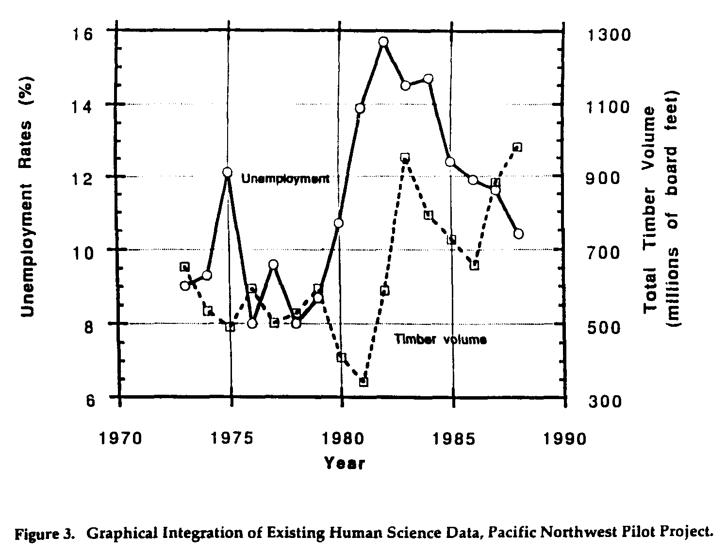
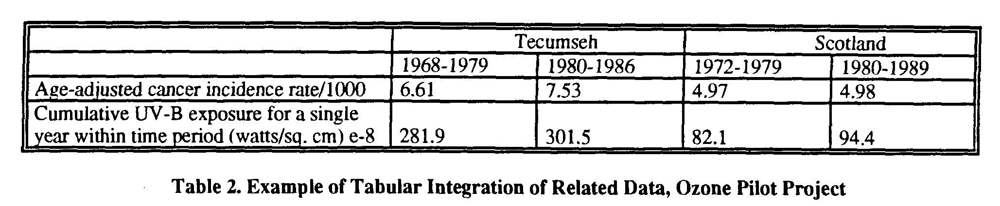
The pilot projects demonstrated many methodologies for both integrating existing data and deriving new data and information. Methods found to be particularly successful included graphical, geographical, and image-based technologies, such as graphical and tabular integration, mathematical and statistical analysis, conceptual and analytical models, geocorrection models, and geographic information system (GIS) technology. Moreover, the simpler types of integration (e.g., graphical and tabular integration) were effective for combining data that have some common collection characteristic, such as similar time periods and/or geographic areas. An example of integration of this type for a single geographic area is the Pacific Northwest project graph of the temporal trend of unemployment and timber volume harvested for a county in Washington state (Figure 3). Another example, this time from the Ozone project, compares estimated UV-B exposure (watts/sq. cm.) and cancer incidence (Average Age-Adjusted Annual Cancer Incidence for Two Time Periods Among Men and Women Ages 45-69 Years) for a similar period of time, but two different geographic areas (Tecumeseh and Scotland) (Table 2).
A somewhat more complex type of integration and analysis was illustrated by the mathematical and statistical procedures employed by several of the pilot projects. Mathematical clustering and similarity analysis were used by several pilot projects. Statistical procedures such as correlation and regression were also used.
Models were also used for integrating and analyzing data. Conceptual models are potentially useful to both scientists and applied users for visualization and understanding relationships between system components and defining the needs for data. The Madagascar project initiated development of a forest system exploitation model to explain relationships between human and environmental factors that influence the use of forest resources. This modeling technique was also used in the Pacific Northwest project (See Figure 2). Analytical models, such as the mathematical model for deriving ozone exposure developed by the Ozone pilot project, are mainly useful to the scientist as an integration tool, although the result (ozone exposure) may be useful to both scientists and applied users.
Another significant use of models was to integrate different sets of image-based satellite remote sensing data for subsequent analysis. Geocorrection models, radiometric correction models, and change detection models were useful in integrating separate remote sensing data sets from different times and different sensors for assessment of changes. Spectral data transformation models were used. Their purpose is to integrate several spectral bands of remote sensing data to create new variables that maximize the potential for displaying and analyzing information for specific applications. For example, the Mexico pilot project used the Tasseled Cap Transformation to produce phenomenologically-significant information for crop and vegetation identification.
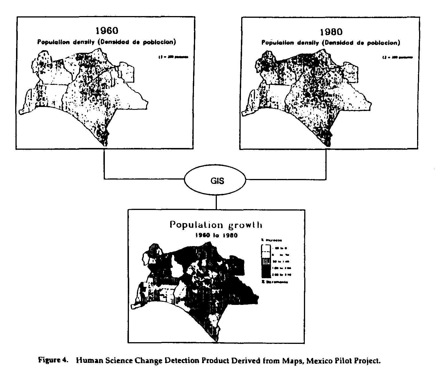
Perhaps the most significant methodology for integration and analysis of data for global change studies was exemplified by the use of geographic information system (GIS) technology. Many of the pilot projects used a GIS to integrate a variety of types of spatially formatted natural and human science data and remote sensing data. These projects demonstrated a variety of analysis procedures that resulted in several forms of derived data and information products. For example, change images were a common form of GIS product. The Mexico project compared different human science variables collected at different times to determine magnitudes of change and areas affected. Figure 4 shows the kind of demographic change map that resulted.
Integration and joint analysis of remote sensing data and selected natural and human science variables was also used to produce derived data or information products. The Dominican Republic project produced a thematic image map of coastal water depth (Figure 5). Generating this product involved using a water-depth algorithm to integrate remote sensing data, water depth measurements, and bottom type reflectance measurements. A perspective view model was used to integrate remote sensing and digital topographic data to convert a forest change image developed by the Pacific Northwest project into an oblique-view perspective (Figure 6). Such images are potentially valuable for analytical use, as well as for visualization and knowledge transfer.
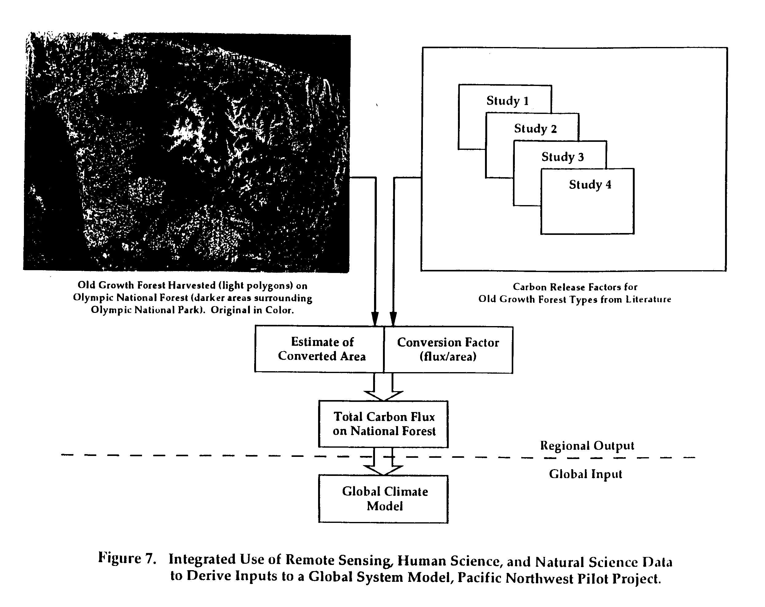
The Pacific Northwest project also demonstrated joint GIS analysis of remote sensing information, natural science information and human science information, to derive inputs for a model of carbon exchange due to logging. Change information derived from remote sensing data was integrated in a GIS with maps of old growth forest and national forest boundaries. Logging of old growth forest on U.S. Forest Service land was then determined through a co-occurrence analysis. The co-occurrence data on area of old growth logged were then combined with carbon flux conversion factors from the literature to produce inputs to a model that generated an estimate of the net carbon flux on the National Forest due to old growth logging. The procedure and its components are outlined in Figure 7.
4.0 CONCLUSIONS AND RECOMMENDATIONS
CIESIN's pilot projects have provided a better understanding of the process of global change research. Consideration of the findings of the pilot project program described in this report has led to the development of three major conclusions, which are helping CIESIN define its role as a facilitator of global change research and as a developer of global change data products and services for researchers and decision makers.
Effective research in the human dimensions of global change will require a different approach than that which has been used in research on the physical processes of global change. Key findings include the following:
Policy-directed global change research for decision makers may require innovative, proactive support programs. These activities include understanding decision makers' needs for information, producing credible information that is relevant to these needs, and transferring that information to decision makers in understandable forms. In order to accomplish these objectives in an effective way, the various components of a global change research process must be integrated and focused.
* Presented at the 25th International Symposium, Remote Sensing and Global Environmental Change, Graz, Austria, 4-8 April 1993.