 Reproduced, with permission, from:
Thomas, M., N. Roller, J. Colwell, and C. Kottak. 1993. Integrating regional studies of deforestation into a global change context. In Proceedings of the 25th International Symposium on Remote Sensing and Global Environmental Change, 559-70. Vol. 1. Ann Arbor, MI: Environmental Research Institute of Michigan
Reproduced, with permission, from:
Thomas, M., N. Roller, J. Colwell, and C. Kottak. 1993. Integrating regional studies of deforestation into a global change context. In Proceedings of the 25th International Symposium on Remote Sensing and Global Environmental Change, 559-70. Vol. 1. Ann Arbor, MI: Environmental Research Institute of MichiganM. ThomasConsortium for International Earth Science Information Network
N. Roller and J. Colwell
Environmental Research Institute of Michigan
C. Kottack University of Michigan
Deforestation is a land cover change that physically occurs on a local or regional level, but which collectively has global effects. To understand, predict, and manage deforestation at the global scale, it is necessary to integrate data from both human and natural science disciplines and generalize from the results of local and regional studies.
CIESIN-sponsored investigations of deforestation in the United States, Madagascar, Indonesia, and Mexico were integrated through a process that included: (1) development and testing of common global change deforestation hypotheses; (2) development, use, and analysis of common human factor questionnaires; and (3) development of a common conceptual model of the deforestation process. The research was designed so that results addressed specific information needs of the land owners, resource managers, and policy makers involved in decisions which may lead to deforestation. Merging remote sensing-derived change images with human science data (e.g., land ownership, local and regional economics, market forces and cycles, and employment data) in a geographic information system, was useful in illustrating the effects of land use policies.
Since the 1970s, much research has been conducted on the local and regional effects of deforestation. Recently, an additional concern has developed about the cumulative effects of deforestation at the global scale. At the 1992 United Nations Conference on Environment and Development, deforestation was identified as a policy issue of global importance. Recent pilot projects sponsored by the Consortium for International Earth Science Information Network (CIESIN) indicate that to effectively understand, manage, and predict deforestation at the global scale, we need to integrate and generalize from the results of local and regional studies. To determine the causes and potential effects of deforestation, studies of deforestation must also include an integration of data from both human and natural science disciplines.
CIESIN's mission is to support global change research and policy development by facilitating access to, use, and understanding of global change data and information worldwide. CIESIN was established as a Congressionally-directed study and demonstration to help optimize the government science information systems by facilitating access to, the use of, and understanding of global change information worldwide. It is particularly concerned with issues associated with the human dimensions of global change.
The CIESIN pilot project program emphasized the understanding of the generic process, issues, and needs of global change research. An additional purpose of the projects was to document the data and methodologies used in real-world global change research, including the practical problems encountered and the solutions that were found. The specific objectives of the pilot project program were to (1) begin to identify the data and information needs of interdisciplinary global change research, emphasizing the "human dimensions" of these needs; (2) explore the issues associated with integrating natural science, human science, and remote sensing data; and (3) demonstrate the feasibility of managing, evaluating, and transferring knowledge generated by global change research to a variety of users to support decision making and policy formulation.
The pilot project program investigated topics related to several important global change issues, including deforestation, loss of biodiversity, climate change, airborne pollution, ozone depletion, and loss of agricultural productivity. Each of the individual pilot projects followed the strategy of studying global change by examining its regional or local manifestations or causes. All projects were initiated with the aim of conducting interdisciplinary research into the human dimensions of an important global change issue, and involving the use of both human science and natural science data. Project teams included investigators who were scientists from both natural and human science disciplines. For a more complete description of the pilot project program, see "CIESIN's Experiences with Integrated Global Change Research" (Thomas and Roller, 1993) also included in the proceedings of the 25th International Symposium.
2.1 Deforestation Pilot Projects
Of the nine pilot projects, five focused on deforestation issues. The project locations and specific investigations undertaken reflected a diverse look at forest resources, including utilizational, international, political, socioeconomic, and ecological perspectives. The projects were located in the United States, Madagascar, Mexico, the Amazonas Region of Brazil, and Indonesia. Each project is briefly described below, with the exception of the Amazonas Project, which is not yet completed.
2.2 Pacific Northwest
This project studied changes the forests of the Pacific Northwest (PNW) region of the United States. This topic and region were selected to investigate: (1) forest management in the PNW can affect the net carbon storage in that region of the world: (2) forest management could have an effect on endangered habitats and endangered species; and (3) forest management in the PNW could have effects on other global change issues, including sustainable yield, fresh water, and Health.
In addition, the implications of PNW forest management throughout the Pacific Rim, and ultimately globally, make the PNW issues easily extrapolated to global issues. Also of interest is that the appropriate way to manage forests in the PNW is currently the subject of considerable debate, locally, regionally, nationally, and internationally. As such, there are a variety of decision makers interested in the debate. Another reason for selecting the PNW is that considerable data and information already exists. Finally, the management of these forests is an ideal subject for learning more about how to integrate the human and natural sciences through multidisciplinary investigations.
The project began by developing an understanding of the elements of the dynamics of forest management in the Olympic Peninsula. A review of the literature and interviews with knowledgeable literature persons led to an initial conceptual model and a candidate list of possible global change hypotheses. This model and these hypotheses guided the subsequent data collection and analysis. A site visit was then made to interview policy and decision makers in the PNW. Subsequent to this visit there was an intensive effort to acquire relevant data from a variety of sources. Some of these data were captured and stored in a GIS. Later, integrated products were prepared. A preliminary human factors questionnaire was also developed and then tested on a second visit to the site. Following a second site visit, the results of the human factors questionnaire were analyzed and additional integrated information products generated.
2.2 Madagascar
Madagascar is an ideal laboratory for the study of the impact of deforestation on biodiversity in relation to land-use patterns, because so many globally recurrent causes and effects are illustrated there. The island has been biologically isolated for 55 million years. Currently, Madagascar has two percent of the world's plant species, although it covers just 0.07 percent of the earth's surface area. Today Madagascar is suffering from massive forest degradation.
This study focused on northern Madagascar, where cash cropping is placing significant pressure on the land, and has been a major cause of forest depletion. A conceptual model was developed to facilitate understanding forest change and to explore the role of humans as agents of deforestation. This model identifies categories of users, their economic needs, and their perceptions of the environment. It is useful for making projections about future environmental impacts by analyzing political, cultural and economic factors relevant to a given environment.
Satellite images and aerial photographs were used to choose four village clusters for integrated research studies. Socioeconomic data were collected by interviews in the four village clusters. The integrated methodology of the study involved systematically cross-checking views from above (satellite images and aerial photographs) and below (biotic and socioeconomic ground truthing). Meetings were held with individuals and groups with various kinds of authority and power at local, regional, and national levels. These meetings were effective for identifying key persons and decision makers.
2.3 Mexico
In Mexico, deforestation is estimated to be around 800,000 hectares, contributing 27.5 tons of carbon to the atmosphere every year. During the past 20 years, Mexican national policies of energy development and colonization have led Mayan Indians to adopt non-traditional and more intense approaches to cultivation that have displaced secondary forest and devastated primary forests through timbering, coffee, and cattle production, as well as traditional agrarian colonization.
The focus of this study was to investigate how various uses of land lead to deforestation in the southeastern region of Mexico. The key objectives of this study were (1) to relate the patterns of deforestation and land use change to the involvement of different local populations in a regional economy dominated by petroleum development, and (2) to evaluate the effect of deforestation on the regional hydrological cycle as it determines the vulnerability of local ecosystems to the impacts of global climate change.
The study explored how to combine global, regional, and local level data into an integrated analysis of complex change. It used remote sensing data at varying scales, including satellite imagery, cartographic aerial photographs, and more detailed ground photographs of land use. It also used the Mexican official population and agrarian census for the region at various dates in the 20th century to study the trajectory of changing regional economic and agrarian organization. It employed anthropological field studies of specific communities whose populations have participated in the transcendental regional changes initiated by Mexican national development policy. Geographical information systems with socio-economic and land use data were used to integrate information on deforestation patterns from satellite images.
2.4 Indonesia, Zimbabwe, and Mexico
The Multi-Method Monitoring (3M) Program in Indonesia, Zimbabwe and Mexico attempted to incorporate disparate sources of physical, biological, social, economic and health data using a Geographic Information System (GIS) to provide spatial analysis capabilities to local planners and policy makers. The approach capitalizes on the intuitive nature of spatial analysis in preference to the more abstract quantitative and tabular statistical presentations of data.
The project in Indonesia included two components: (1) introducing a simple GIS to regional planning offices, and (2) exploring the causes and consequences of deforestation in the Lahat District of South Sumatra. Remote sensing data have been integrated into the local monitoring system and used to provide baseline data for the Lahat study. In Zimbabwe, an ARC/INFO system was used to tie together data sets (including Landsat images and aerial photography) to evaluate a small village development project in the Merewa Development District. Merewa is one of the communal areas where land pressures and population growth are significant factors in regional deforestation. The Mexico portion of the study did not deal with deforestation issues.
3.0 RESULTS AND DISCUSSION
Although the four pilot projects supported by CIESIN investigated different aspects of deforestation, they shared a common theme: to investigate deforestation using an integrated, interdisciplinary methodology. The projects resulted in several general observations or findings with respect to their use in integrating local and regional studies on deforestation into a global context. Each finding is discussed individually.
Finding: Global change issues are multidisciplinary in scope. Global change is a combination of physical change and human influences on and reactions to those changes. Therefore, the research efforts to understand deforestation as a global change must investigate both natural and human science cause and effect. Moreover, to understand, manage, and predict deforestation at the global scale, we need to integrate and generalize from the results of local and regional studies, and these studies must include an integration of data from both human and natural science disciplines.
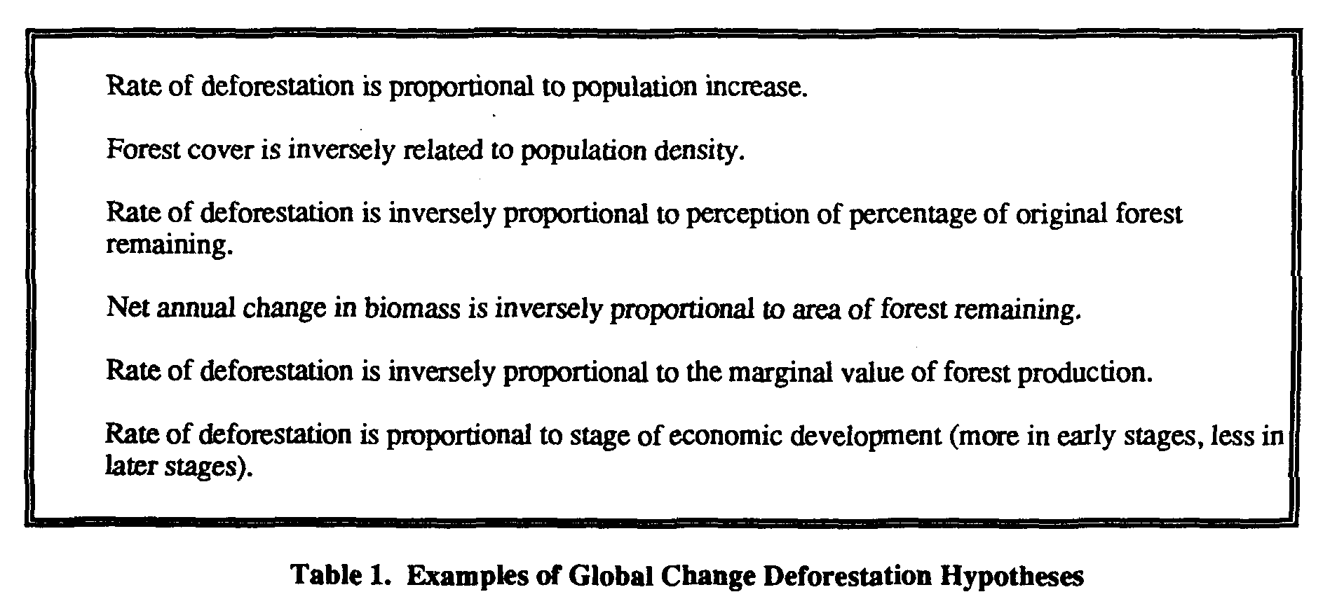
One of the most important elements of integrating the natural and human dimensions of the issue is the development and testing of common global change deforestation hypotheses. In order for effective research on the global effects of deforestation to be achieved, global change hypotheses, models, and variables need further development and acceptance.
Discussion: Results of the deforestation pilot projects, conducted in widespread regions of the world suggest a set of common or "baseline" global change deforestation hypotheses that ask similar questions and that facilitate collecting comparable data about forest dynamics in separate geographic areas. Suggested global change deforestation hypotheses are shown in Table 1.
Rate of deforestation is proportional to population increase.
Forest cover is inversely related to population density.
Rate of deforestation is inversely proportional to perception of percentage of original forest remaining.
Net annual change in biomass is inversely proportional to area of forest remaining.
Rate of deforestation is inversely proportional to the marginal value of forest production.
Rate of deforestation is proportional to stage of economic development (more in early stages, less in later stages).
Table 1. Examples of Global Change Deforestation Hypotheses
Establishing common hypotheses relatively early in the planning process will help in the selection of questions that need to be addressed, appropriate variables to measure and models to use, technical expertise needed on the research team, and milestones to be tracked. The PNW and Madagascar projects agreed, in advance, that there were relevant hypotheses that could be studied in these quite different socio-economic environments. An example of a common global change hypothesis investigated by these projects is that the perception of a person, group, or society concerning the amount of deforestation that has already occurred will affect the propensity to be involved in or accept further deforestation. Another example is that people perceive more adverse effects of deforestation when they don't directly benefit from it.
Another important element of research integration is the development of a common conceptual model of the deforestation process, although it is perhaps the most difficult element to achieve. This is principally due to the fact that the human dimensions of deforestation add an additional overlay of variables to a model already complicated by physical and biological factors. Limiting the model to the hypothesis selected and variables measured is one way of simplifying a model. For example, the forest exploitation system model developed in the Madagascar study was limited to external natural variables (e.g., climate change, drought, cyclone, exotic species invasion), external anthropogenic variables (e.g., political instability, policy change, fuel crisis, recession, migration), human exploitation (e.g., commercial logging, fuel-wood gathering, commercial agriculture), and location of infrastructure.
Broadly speaking, the projects used three major classes of data: human science, natural science, and remote sensing data. Probably most global change research projects emphasizing the human dimensions of global change will require a mix of these classes of data. Generalization about the appropriate mixes and proportions of data types beyond this point becomes difficult because the particular combination of variables (e.g., demographics, economics, attitudes and perceptions, and land cover) that are required for a given research project are highly dependent on the specific global change issue under consideration.
Selection of appropriate variables to measure, particularly in the human sciences, needs further development, partly because the questions being asked by scientists and policy makers are not always clear. This requires that the investigators understand the needs of the user groups-the land owners, resource managers, and policy makers-involved in decisions which may lead to deforestation. The use of survey research is a valuable source of information about the causes and effects of global change, particularly in the human dimensions. However, considerable thought must be given to construction of surveys that are relevant to the topic, or to the hypothesis selected.
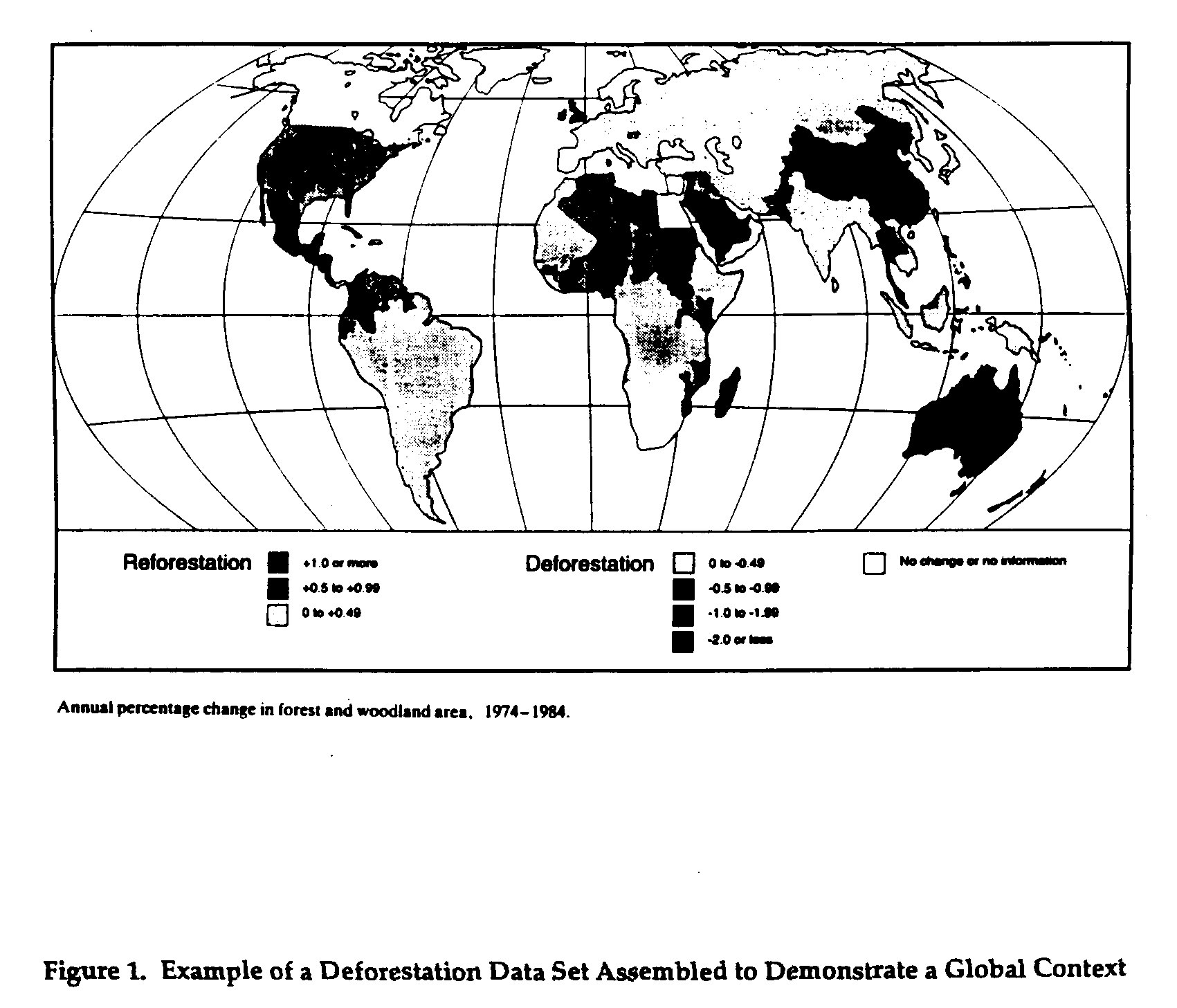
Selection of a study site that is appropriate in the sense that it will support testing a global hypothesis is also important. Global coverage data sets which suggest where important interactions are taking place between humans and their environment are especially useful for this purpose. An example of a deforestation data base assembled to provide a global context is shown in Figure 1.
Finding: Methods of integrating and presenting data found to be particularly successful included graphical, geographical, and image-based technologies.
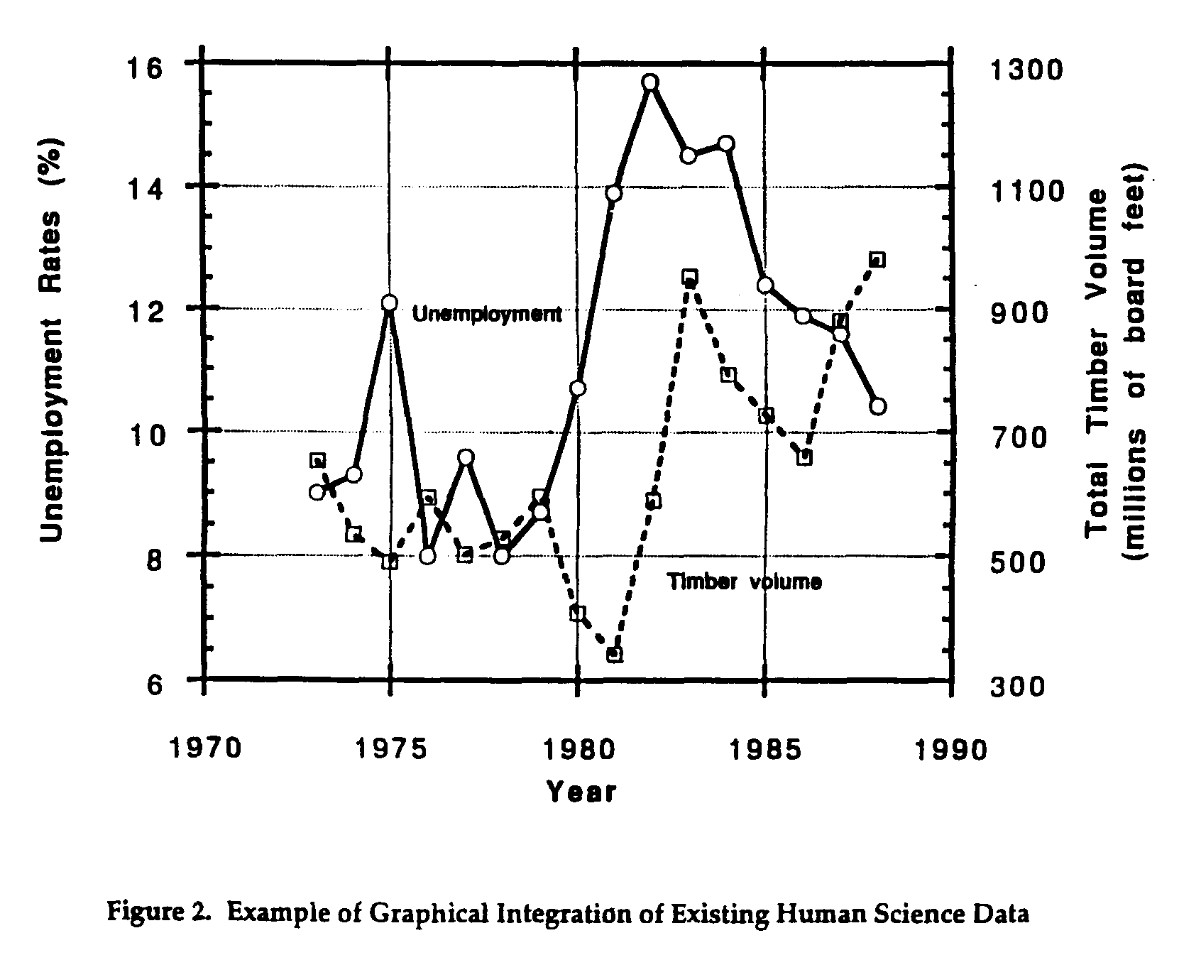
Discussion: The pilot projects demonstrated many methodologies for both integrating existing data and deriving new data and information. Among the simpler integration methodologies were graphical and tabular integration, which were effective for combining data that have some common collection characteristic, such as similar time periods or geographic areas. An example of integration of this type for a single geographic area is the Pacific Northwest project graph of the temporal trend of unemployment and timber volume harvested for a country in Washington state (Figure 2). In fact, it was observed across all projects that the simpler types of integration were valuable to both the investigator and to policy makers. By merely providing data access and combining appropriate data variables, CIESIN was able to directly meet the needs of many user groups without large expenditures of resources or lengthy product development activities.
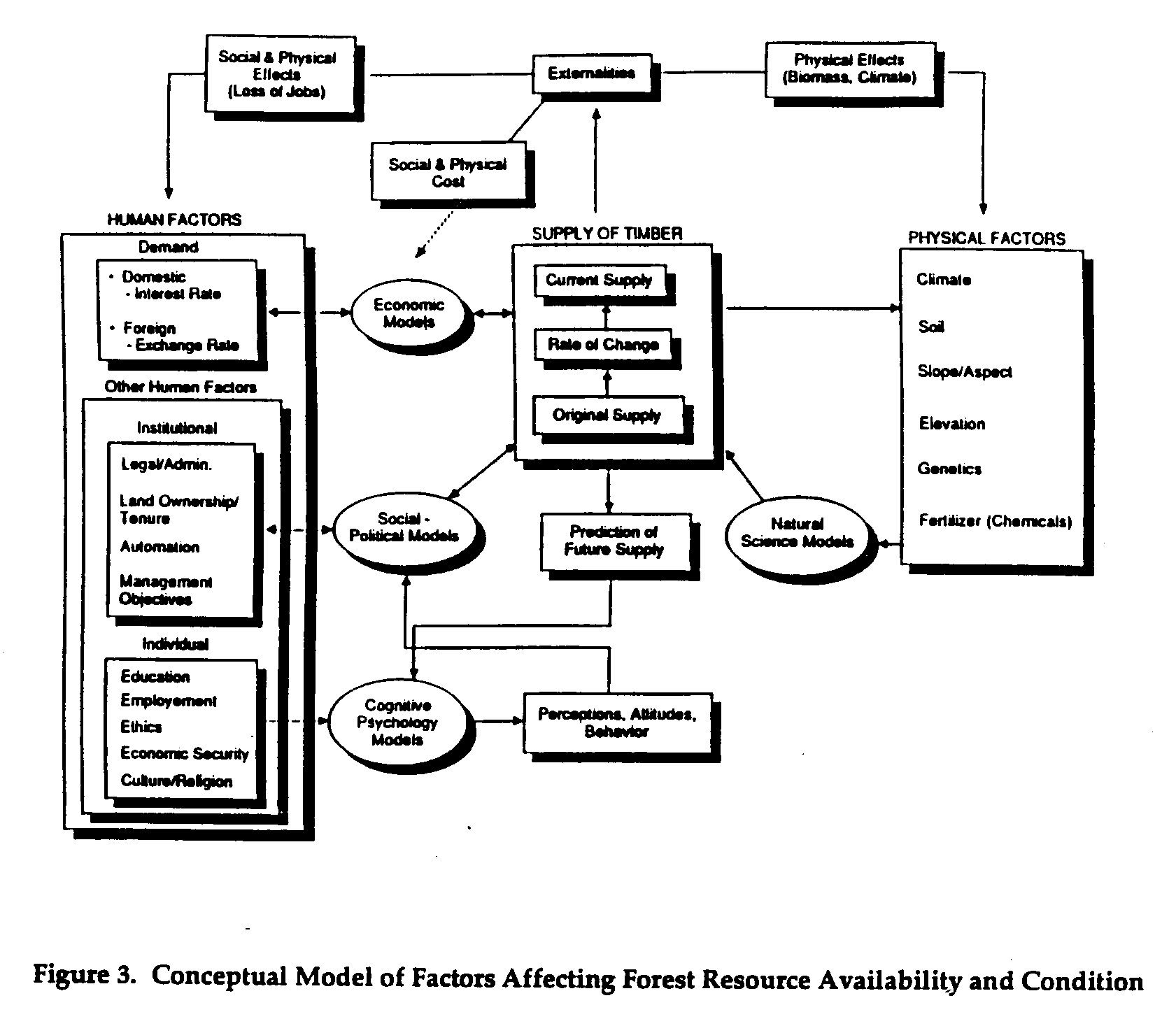
Among the more complex types of integration and analysis were the mathematical and statistical procedures: e.g., mathematical clustering, similarity analysis, correlation, and regression. Models were another mechanism used by the pilot project investigators for integrating and analyzing data. Conceptual models are potentially useful to both scientists and applied users for visualization and understanding relationships between system components and defining the needs for data. The Madagasar project initiated development of a forest system exploitation model to explain relationships between human and environmental factors that influence the use of forest resources. The Pacific Northwest demonstrated development of a conceptual model of the factors affecting forest resource availability and condition (Figure 3). Analytical models were used to integrate image-based satellite remote sensing data for
subsequent analysis. Geocorrection models, radiometric correction models, and change detection models were all useful in integrating separate remote sensing data sets from different times and different sensors for assessment of changes. A typical example of the type of product they were used to generated is the Landsat derived forest change image. Spectral data transformation models were also used. Their purpose is to integrate several spectral bands of remote sensing data to create new variables that maximize the potential for displaying and analyzing information for specific applications. For example, the Mexico pilot project used the Tasseled Cap Transformation to produce phenomenologically significant information for crop and vegetation identification.
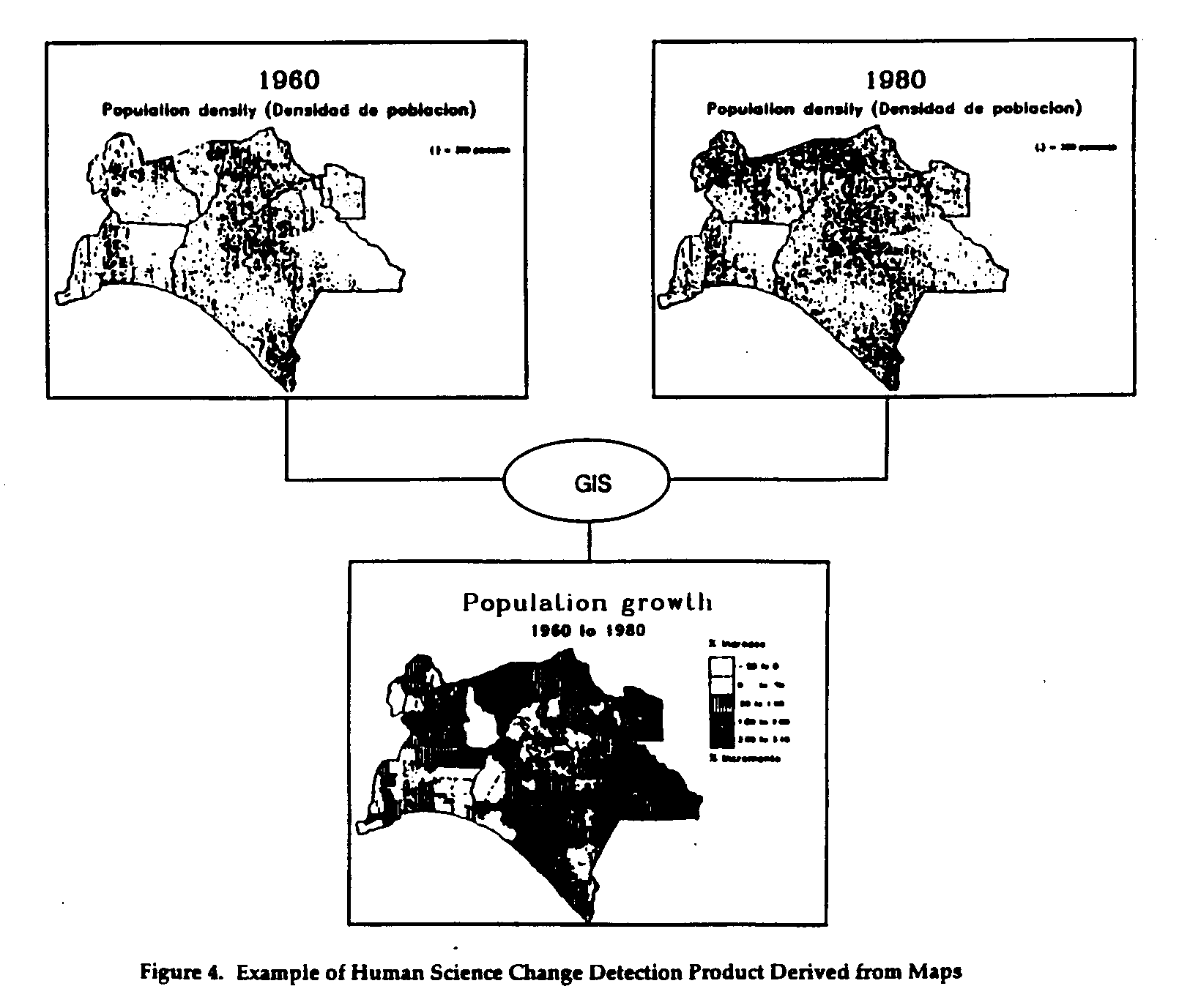
Perhaps the most significant methodology for integration and analysis of data for global change studies was exemplified by the use of GIS technology. Many of the pilot projects used a GIS to integrate a variety of types of spatially formatted natural and human science data and remote sensing data. These projects demonstrated a variety of analysis procedures that resulted in several forms of derived data and information products. Change images were a common form of GIS product. The Mexico project compared different human science variables collected at different times to determine magnitudes of change and areas affected. Figure 4 shows the kind of demographic change map that resulted.
Many of the pilot projects demonstrated integration and joint analysis of remote sensing data and selected natural and human science variables within a GIS to achieve a derived data or information product. A perspective view model was sued to integrate remote sensing and digital topographic data to convert a change image developed by the Pacific Northwest project into an oblique-view perspective (Figure 5). Such images are potentially valuable for analytical use, as well as for visualization and knowledge transfer.
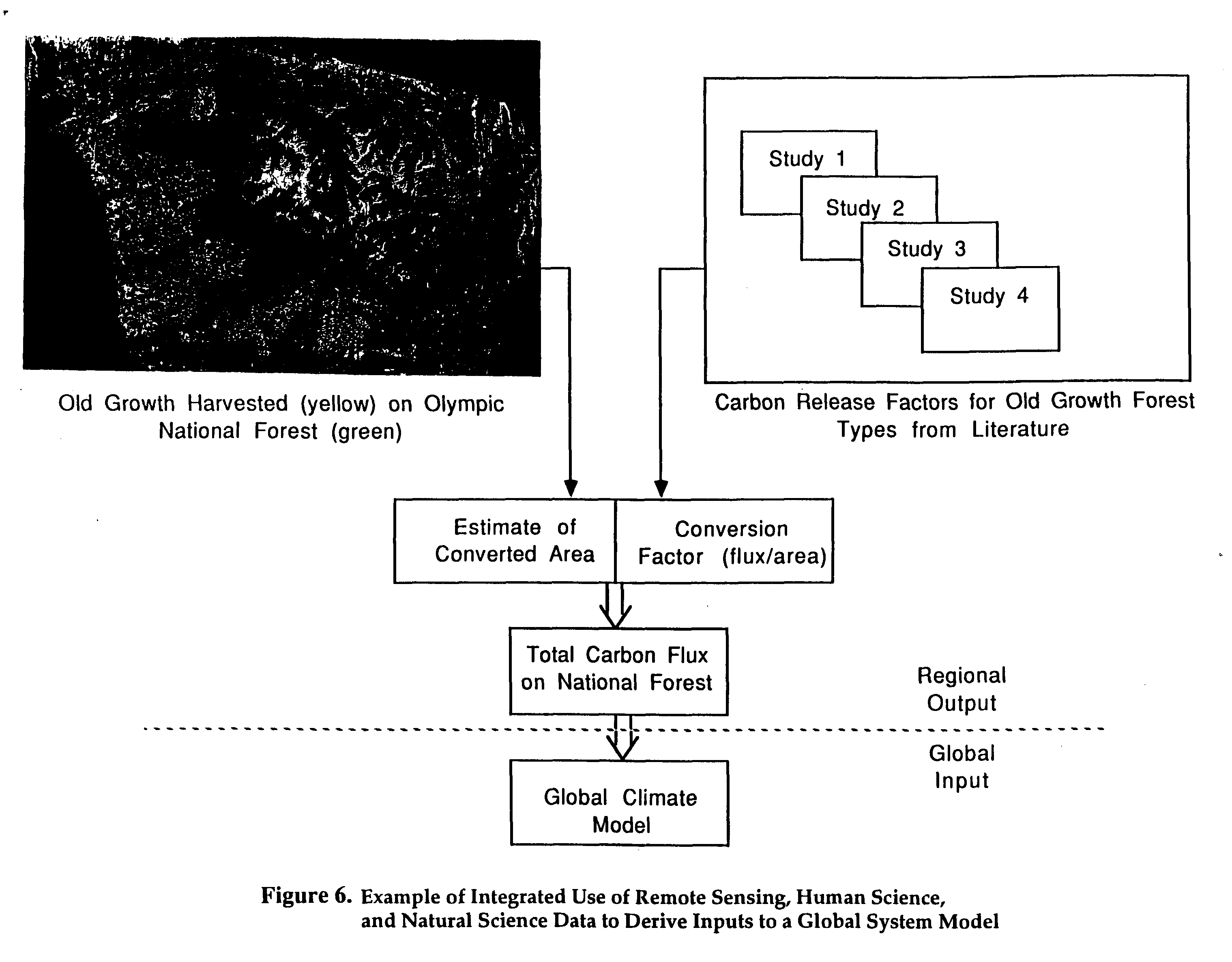
The Pacific Northwest project demonstrated Joint GIS analysis of remote sensing information, natural science information and human science information to derive inputs for a model of carbon exchange due to logging. Change information derived from remote sensing data was integrated in a GIS with maps of old growth forest and national forest boundaries. Logging of old growth forest on U.S. Forest Service land was then determined through a co-occurrence analysis. The co-occurrence data on area of old growth logged were then combined with carbon flux conversion factors from the literature to produce inputs to a model that generated an estimate of the net carbon flux on the National Forest due to old growth logging. The procedure and its components are outlined in Figure 6.
Finding. Satellite and other remotely sensed data were very helpful in deriving data on deforestation and presenting results in an understandable form. Remotely-sensed change detection images often provided the most useful information.
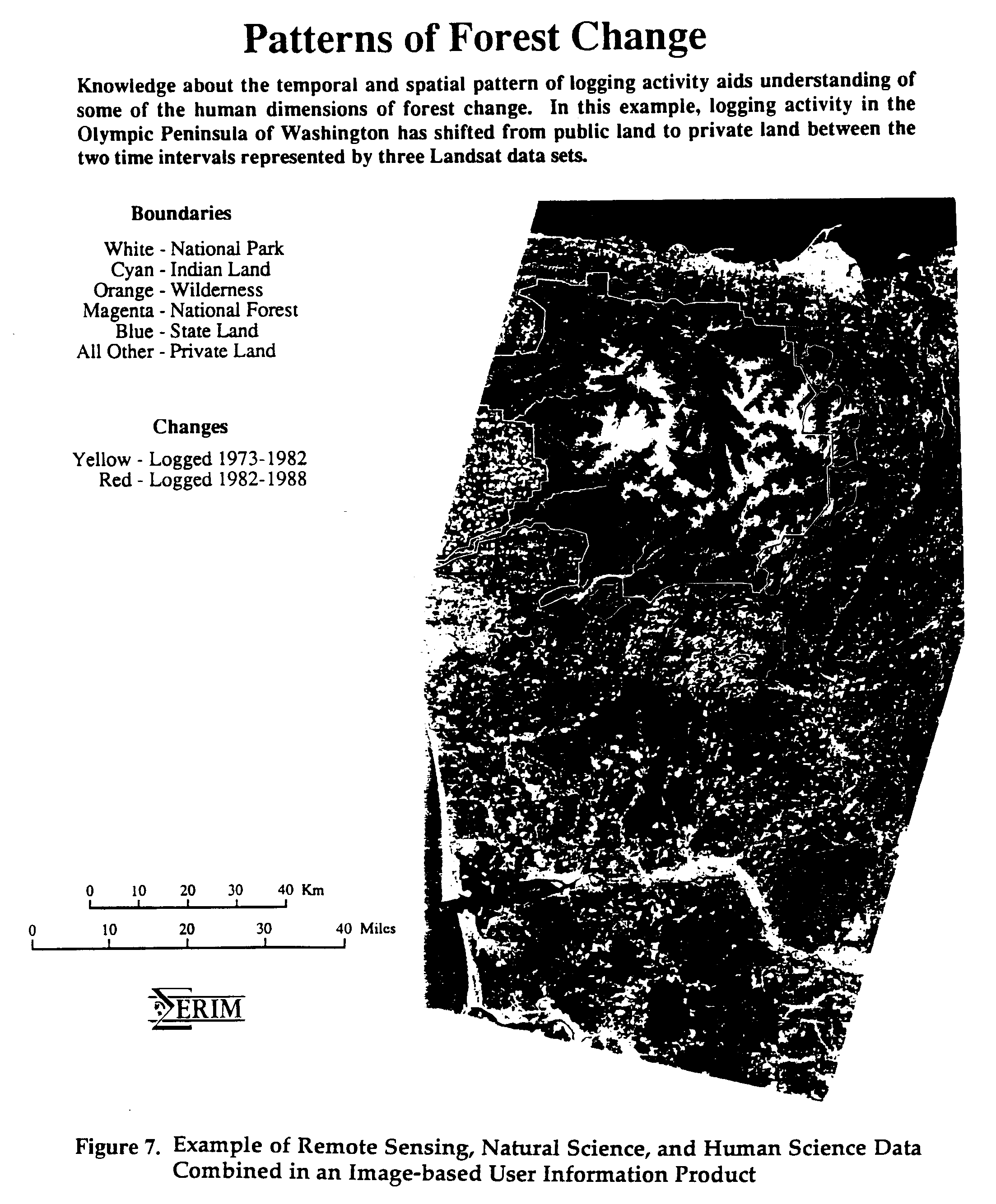
Discussion. Remote sensing played a major role in facilitating collection of new human and natural science data. This is somewhat of a departure from the general situation, because although natural scientists routinely use remote sensing data, the same cannot be said for human scientists. In this program, because of the support (both technical and financial) and encouragement they received, several human scientists experimented with remote sensing and found it useful to their studies. Figure 7 shows an example of its usefulness for integrating human science data.
The kinds of natural science data accessed, collected, or created typically included forest cover at various time intervals, biomass, and species composition. Information about changes in each of these databases over time were specifically sought. Integrated natural-social science information that was also sought included patterns of land use and land-use change over time. This information can be used by the researcher and policy maker to determine where, when, and how much deforestation occurred. Social science data that was sought included population density and dynamics, resource demand and other economic factors, cultural and political considerations, and perceptions of the environment and what constitutes environmental impact. This information can be used to determine the why and so what questions of the studies' hypotheses.
Satellite remote sensing data were found to be very helpful deriving this information and in presenting it. Remote sensing derived change images were especially effective identifying how much deforestation occurred and where it occurred in a certain time period. Remote-sensed images were found to act as surrogates for demographic and economic factors, for example, in Madagascar, hut density could be used as a measure of population density, the presence of a tin roof on a hut was a measure of wealth, and the occurrence of roads and other routes into forested areas provide some indication of opportunities for resource exploitation. When this information was merged with human science data (e.g., land ownership, local and regional economics, market forces and cycles, and employment data) in a GIS, it also illustrated effects of the policies of the land owners.
Finding: Research into global change issues must be planned and carried out for the purpose of developing products and services which meet specific needs of the land owners, resource managers, and policy makers involved in decisions which may lead to deforestation.
Discussion: Deforestation issues of concern to decision makers vary with time, type of decision maker, and the geographic location of decision maker. The information needs of decision makers are determined by what they perceive to be currently important global change issues to which they are required, or to which they wish, to react.
The pilot projects demonstrated that identification of user needs involves two key activities. First, an analysis of the information needs of decision makers; and second, an analysis of the associated data needs of scientists who are trying to supply the decision-makers with information. For example, the Pacific Northwest project made extensive lists of potentially interested science users and applied users from (among other sources) current newspaper articles.
Finding. It was observed that, contrary to the common presumption that scientists and decision makers need significantly different kinds of information, simple data and information products that were highly relevant to the issue were generally helpful to research teams, government decision makers, and the local populations. The key to this utility is to make the data accessible and comparable in the context of policy issues and significant research questions.
Discussion. In many cases, generation of such products filled previous gaps in the data base available to both user groups. Simple line maps and remote sensing images, particularly in large-scale and natural color were shown to be widely accepted by the public and by policy makers. Moreover, the demonstration of maps and images of local areas demonstrates to the local population a real interest in them and their area--one way of overcoming an inherent distrust of strangers and researchers.
Researchers and field personnel without pervious training in remote sensing interpretation also preferred these images despite inherent problems associated with loss of resolution and computer enhancement. The availability of these images also enhanced ground truthing, since local people who were more familiar with the area could assist in interpreting the images. Since filed time is expensive, reducing the time needed for ground truthing could result in significant cost savings.
The Madagascar project also found it is extremely important to have current satellite remote sensing data available during data integration planning activities. In many developing countries, maps are not available or are seriously outdated. Moreover, the lack of access to all but the simplest database interpretation technology and expertise sets a limitation on the effectiveness of combining multiple sources of information into one image or graphic. Current satellite imagery can aid in both the logistical planning for, and the collection of, compatible natural and human science data.
Other examples include graphs of temporal trajectory of related relevant data (e.g., timber harvest vs. unemployment and two different and partially conflicting maps of "old growth forest").
4.0 CONCLUSIONS
The four pilot projects investigating deforestation were international in scope. In order to understand the global effects of deforestation, the projects attempted to use an integrated, multidisciplinary approach to studying deforestation at the local and regional levels. The results of the pilot program suggest that effective integration is difficult to achieve, but that is possible. Problems to overcome include the different perspectives and approaches of individual members of a research team, the general lack of human science data on global change issues, developing a data collection plan that adequately addresses user needs or issues, and then delivering the information products which meet the needs of the land owners, resource managers, and policy makers involved in decision which may lead to deforestation.
The pilot projects demonstrated that an integrated, interdisciplinary approach is useful in providing (1) a better understanding of the process of doing global change research was gained; and (2) a better understanding of how CIESIN and others can facilitate the process of doing global change research. A successful global change research project, in general, must have an integrated, natural and human science data collection plan, a conceptual model of the deforestation process, and a clear understanding of the needs of the user groups in order to develop the desired products. For individual local and regional projects to have a global change context, they also need to collect related and comparable data and provide the opportunity to address global change hypotheses. Remote sensing can play an important role in each of these activities, particularly in the use of simple, true-color satellite imagery to establish baseline conditions and derived change images to show historical changes and current locations of rapid change.