 Reproduced, with permission, from:
Cohen, S. J. 1986. Impacts of CO2-induced climatic change on water resources in the Great Lakes Basin. Climatic Change 8: 135-53.
Reproduced, with permission, from:
Cohen, S. J. 1986. Impacts of CO2-induced climatic change on water resources in the Great Lakes Basin. Climatic Change 8: 135-53.
Canadian Climate Centre, Environment Canada, Downsview, Ont. CANADA
Abstract.
Scenarios of CO2-induced climatic change, based on models produced by the Goddard Institute for Space Studies (GISS) and the Geophysical Fluid Dynamics Lab (GFDL), were used to estimate future changes in water supply in the Great Lakes Basin. The major components of annual Net Basin Supply, surface runoff and lake evaporation, were estimated using the Thornthwaite water balance model and the mass transfer approach, respectively. Two scenarios were derived from each climatic change model, one based on present normal winds, the other assuming reduced wind speeds. A third scenario was derived from GFDL, using wind speeds generated by the GFDL model, Results varied from a decrease in Net Basin Supply of 28.9% for GISS-normal winds, to a decrease of 11.7% for GFDL-reduced wind speeds. All five scenarios projected decreases. These differences in projection will have to be considered when performing climate impact studies, since economic activities affected by lake levels would probably experience different impacts under these scenarios.
During the last 100 yr, atmospheric CO2 concentration has increased by about 20%. This has generated considerable debate regarding its possible effects on future climate (U.S. NRC, 1982; Jager, 1983; U.S. EPA, 1983; Bach, 1984a; Palutikof et al, 1984). Recently, this debate has extended beyond projecting climatic changes to estimating the impacts of such changes on society (e.g. Bach et al, 1979; Climatic Planning Board, 1979; Ausubel and Biswas, 1980; Miller, 1980; Slater and Levin, 1981; Thornes, 1981; Kellogg and Schware, 1981; Clark, 1982; Idso, 1982; lager, 1983; Ausubel, 1983; U.S. DOE, 1983; Chen et al, 1983; Sewell et al., 1984; Bach, 1984b; Kates et al., forthcoming).
Much of the above literature concentrates on specific activities, most notably agriculture and energy. However, if we consider an individual region, such as the Great Lakes basin, we must broaden the scope of climate impact studies so as to include other major sectors of the economy, such as water resources. This is a key issue in the Great Lakes basin, since various facets of the regional economy are closely linked to lake levels and 'Net Basin Supply' or NBS (IJC 1975, 1981a). Small fluctuations in lake levels have caused significant damage in the past, including losses in hydro-electric power production, lake shipping, and shoreline erosion (Bruce, 1984). In addition, a major decision confronting future generations is whether or not to export water to the High Plains area of the western United States (DeCooke et al., 1984; Glantz and Ausubel, 1984). Although several diversions already exist in the basin, proponents of future diversion projects envision much larger transfers of water, approximately three times the outflow of the Chicago diversion (DeCooke et al, 1984).
Concurrent to the above external demands for Great Lakes water, internal demands are expected to increase significantly, perhaps by as much as seven times above present consumptive use. This 'worst case' scenario of approximately 1050 m3 s-l or CMS (37000 cfs) is more than 10 times higher than the 90 CMS (3200 cfs) outflow at the Chicago diversion (IJC, 1981b). Note that this projection was made on the basis of economic and demographic factors. Scenarios of climatic change were not considered. In an address to the 1984 Futures in Water Conference held in Toronto, Bruce concluded that the IJC study results would have to be modified by CO2-induced climatic warming, specifically in its projections of irrigation demands and cooling requirements for thermal power plants. Municipal demands would also increase.
How would a doubling of CO2 in the atmosphere affect the climate, and in turn, the regional economy of the Great Lakes? This is a region with a broad mixture of urban and rural land uses, with a drainage area of approximately 766 000 km2, of which 32% is lake surface. Its total population is expected to grow from 35 to 50 million by 2035 (IJC, 1981b). Approximately 80% of the population and 59% of the surface area are in the U .S., but the Canadian side includes Metropolitan Toronto, Canada's largest city. A climate impact assessment of CO2-induced climatic change on the Great Lakes must therefore be broad enough to consider direct and indirect impacts on a wide range of activities, as well as being sensitive to population change. In addition to the above, many indirect impacts of climatic change result from possible changes in lake levels.
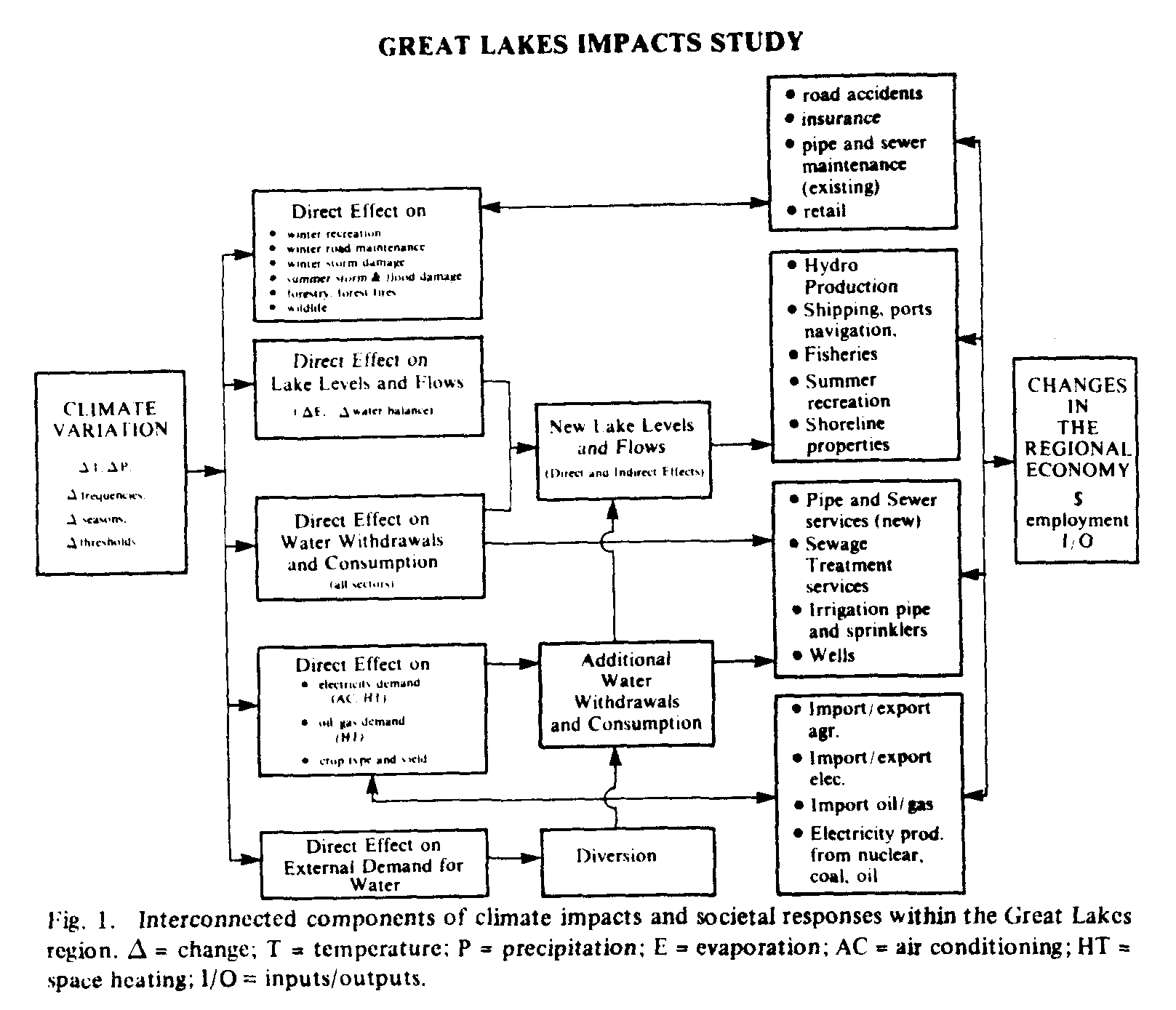
This paper concerns the impacts of CO2-induced climatic change on the Great Lakes. Since there has not been any previous attempts at modelling such impacts, it is necessary to define the problem, and then to demonstrate how the hydrologic components fit in. The most difficult aspect about doing this particular climate impact assessment is in designing a general framework that is not only broad, encompassing all relevant sectors, but is also region-specific. The Great Lakes regional economy is inextricably linked to the lakes themselves. So, a projection of future lake levels and NBS is not only important in its own right, but is also a key step in the assessment of economic and environmental impacts as well. It is hoped that by presenting my proposed framework, a catalyst would be provided for continued efforts by specialists in other disciplines who may present frameworks of their own.
Figure 1 provides a 'first draft' of my proposed framework. In this framework, changes in lake levels are the key to determining impacts on hydro-electric power production, shipping (land and water), recreation, water distribution services, and water quality. Lake levels are determined by climate, but are also influenced by consumptive use of water by municipalities, utilities, and farmers. Note that there are some endeavours, such as winter recreation, that are not affected by lake level changes, but would certainly be influenced by climatic change. Note also that there are a number of import/export questions, as well as the diversions issue, a consequence of the international nature of this basin.
Of the various impact scenarios that could be drawn from a scenario of climatic change, one of the most interesting concerns the energy sector. If reductions in streamflow and lake levels occur, this will result in losses in hydro-electric power production, which could be met by increased use of coal and nuclear power, and perhaps alternate forms of energy (e.g. solar, wood, biomass). Water would be required for cooling purposes, thereby increasing consumptive use (IJC, 1981b), leading to further reductions in flow. Superimposed on this scenario is a projected change in energy demand for heating and cooling. Warmer winters would reduce consumption of all fuels, but warmer summers would lead to higher demand for electricity to operate air conditioners. As a result, regional utilities would experience changes in the seasonal demand cycle, and it may become more difficult for Ontario Hydro to export electricity during the summer to help meet the peak summer demand in the U.S. (Ontario Hydro, 1984). Will this lead to the construction of additional nuclear and/or coal-fired power plants in the U.S., or greater imports from Manitoba and Quebec ? Will greater use of photovoltaics and other alternatives be encouraged? How will the mining industry, electricity prices, and industrial activity be affected? Will there be new laws passed to conserve electricity?
Similar impact scenarios can be drawn for other sectors of the economy. In these, as well as the one described for energy, the first step in analyzing the impacts of climatic change is to quantify the direct and indirect effects on lake levels. This requires the estimation of changes in NBS. With that in mind, this study has been undertaken to estimate changes in NBS of the Great Lakes basin resulting from two models of CO2 induced climatic change. These models are similar, in that they both project higher mean annual temperatures and precipitation. However, there are significant spatial and temporal differences in these projected variables within the Great Lakes basin. and these differences will have a major effect on the results, as well as broader implications on climate impact studies of the regional economy.
The emphasis in a climate impact study is on the effects of an altered climate, and not on climatic change itself. Thus, the first task is to obtain data on basic climate parameters from operational climate models. The climate scenarios are adaptations of the models' outputs, approved for use within the Canadian Climate Program in September, 1984. The models chosen were produced by the Goddard institute of Space Studies (GISS) and Princeton University's Geophysical Fluid Dynamics Lab (GFDL). U.S. EPA (1984) used output from the GISS model in a study of potential impacts of CO2 induced climatic change on water resources in the United States.
The GISS and GFDL models are global scale General Circulation Models, which require parameterizations of a number of terms that are used to solve the fundamental equations for conservation of mass, momentum, energy, and water. These terms represent the physical processes of radiation, turbulent and latent heat fluxes, and condensation. However, there are many uncertainties in the modelling and parameterization of terms. Various processes, such as cloud feedbacks, are only crudely modeled. Initial conditions of temperatures and precipitation, i.e. present normals, are difficult to determine for all points. As a result, neither model is able to completely simulate the present climate, especially precipitation. When the initial parameterizations are modified by doubling atmospheric CO2 concentrations, any errors inherent in the initial model runs would probably occur in the 2 x CO2 simulations.
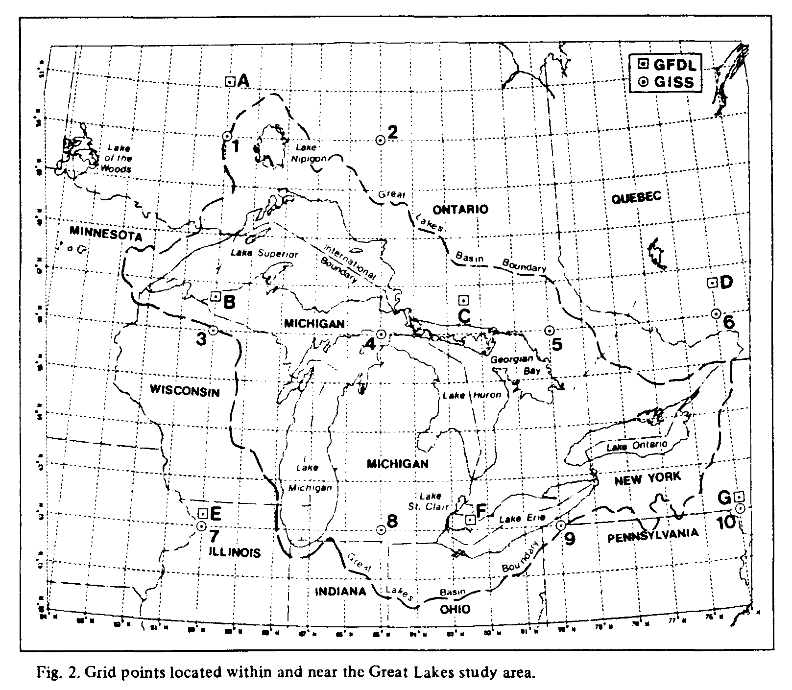
Another problem concerns the relatively coarse resolution of the model outputs. The GISS model's output was originally provided for 8deg. x 10deg. grid squares, only three of which include the Great Lakes basin. There is large subgrid-scale variation, particularly in precipitation (U.S. EPA, 1984), partially due to subgrid-scale topographic features. The GFDL output is also fairly coarse with grid points located at intervals of 4.4deg. latitude and 7.5deg. longitude. This creates uncertainty in the location of simulated future anomalies.
A sensitivity test was performed on the GISS output by shifting the simulated precipitation anomalies by one grid square for the three squares within the Great Lakes basin. The next step was computing the change in annual basin precipitation that would occur if the anomalies were actually located one grid square to the east, west, or north of the squares indicated in U.S. EPA (1984), Figure 2. Using the model-simulated 'normals' from Figure 3b of U.S. EPA (1984), a 0.7% increase from normal was computed for 2 x CO2. A westward shift produced a decrease of 3.1%, while increases of 7.5% and 11.1% were computed for eastward and northward shifts respectively. If we use estimated observed 'normals' from Figure 3c of U.S. EPA (1984), which are 6.8% lower than in Figure 3b, the westward shift produced a decrease of 3.2%, while increases of 0.7%, 8.1%, and 12.0% were computed for no shift, eastward, and northward shifts respectively. These four precipitation values are lower than those based on Figure 3b. This results in a range of nearly 180 mm between the lowest and highest values (765.5 mm for westward shift observed normals, to 942.8 mm for northward shift-simulated normals). This large range would lead to wide variations in runoff and net basin supply estimates, and consequently, a wide range of possible impacts on the regional economy.
In order to provide additional spatial resolution, the GISS output was modified by W. Bach of the University of Munster, West Germany. A denser network of grid points was created, thereby providing a 4deg. latitude x 5deg. longitude spacing of points, with 10 data points in or near the study area. GFDL output contained 7 points (Figure 2).
Model output consisted of monthly temperature and precipitation for 1 x CO2 (present climate) and 2 x CO2 (Greenhouse Effect climate), expressed as anomalies from present observed normals'. However, neither the 1 x CO2 model run, nor the 'normals', were in complete agreement with normals obtained from Canadian and U.S. station data (1951-1980 and 1931-1960 respectively). Thus, the 2 x CO2 anomalies were added to normals estimated by the Canadian Climate Centre for each grid point. These grid point normals were determined from isoline maps based on actual station data.
The modified GISS scenario projects a 4.3 deg.C to 4.8 deg.C increase in mean annual temperature, and a 6.5% increase in mean annual precipitation in the Great Lakes basin. Winter temperatures are projected to increase by 5-6 deg.C, while the increase during summer is 3-4 deg.C. The largest precipitation increase, about 15%, occurs near Lake Superior, while small decreases occur in the eastern half of Lake Ontario. The remainder experiences an increase near the above-mentioned regional figure. Increases are projected for all seasons, except the September-November period in the southern part of the basin (Figure 3).
The GFDL scenario, originally for 4 x CO2, was later modified by the Canadian Climate Centre for 2 x CO2 by dividing the 4 x CO2 monthly anomalies by 2, and adding them to the above set of grid point normals. This was done because the 4 x CO2 scenario has about twice as much heating as the 2 x CO2 scenario. Thus, a linear change in temperature has been assumed. Model output also included monthly wind speed for 4 x CO2 . The above procedure vas used to estimate changes in wind speed for 2 x CO2 .
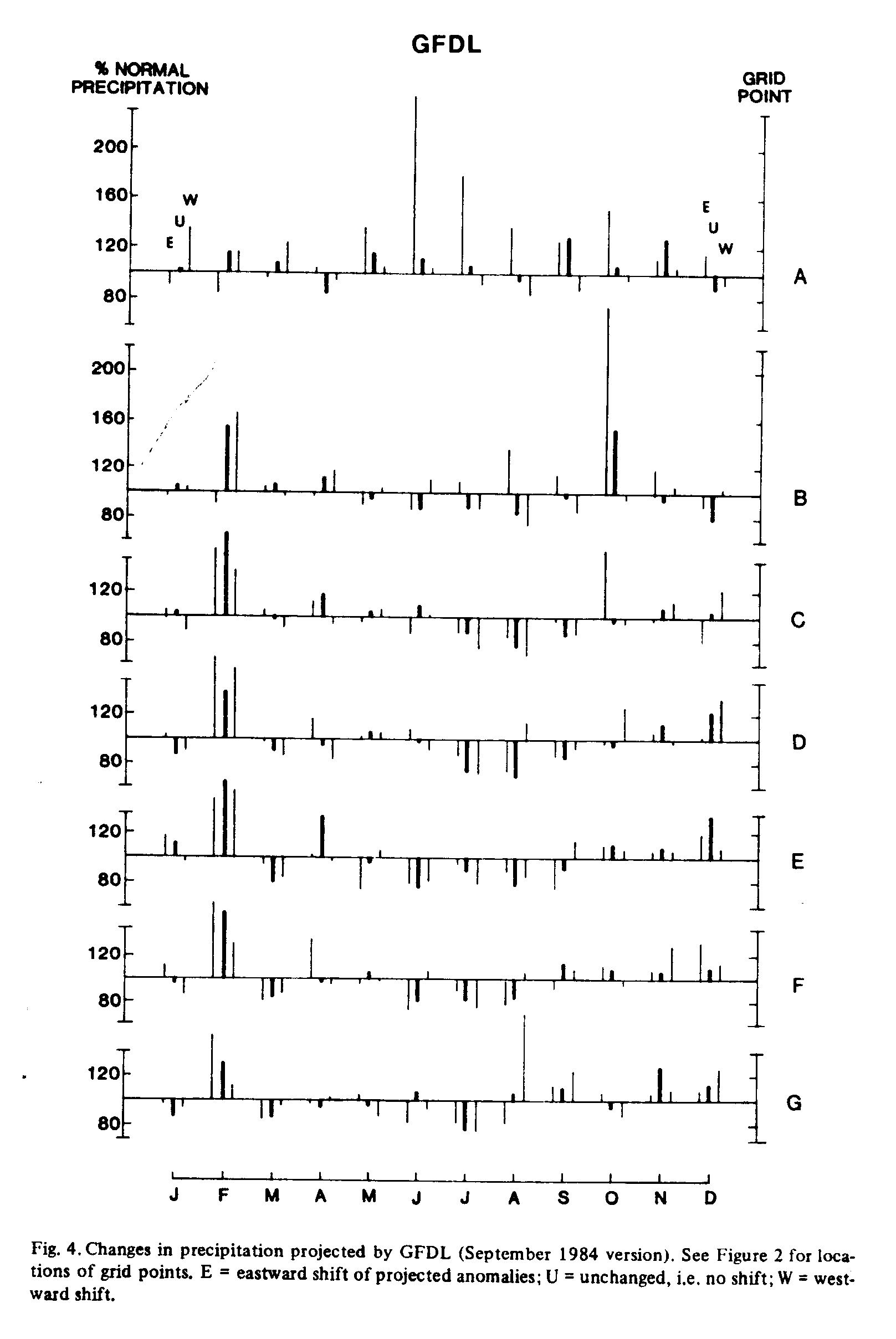
The modified GFDL scenario projects a smaller annual temperature increase than GISS, 3.1 deg.C to 3.7 deg.C, and a 0.8% increase in basin precipitation over the year. Unlike GISS, the Lake Superior area would receive only a marginal increase in precipitation, while Lakes Erie and Michigan would experience small decreases (Figure 4, 'unchanged'). Small increases are projected for the rest of the basin.
A sensitivity test was performed on the GFDL output by shifting the simulated precipitation anomalies by one grid point eastward and westward (Figure 4). In certain months, particularly in the Lake Superior area (points A and B), an eastward shift leads to substantial increases. A westward shift results in a small increase near Lake Ontario, and decreases elsewhere. Overall, an eastward shift would produce a basinwide increase of 5.8%, similar to what was obtained in the GISS scenario for a similar shift. A westward shift produces an increase of 03%, while GISS had showed decreases. The lowest and highest values are 871.4 mm (normals) and 926.6 mm (eastward shift).
When doing a regional impact study, the same uncertainties exist when using both GISS and GFDL scenarios, which are obtained from global climate models. Obviously, more research is needed before climate models will be able to provide accurate simulations at a resolution fine enough for regional scale impact studies. For the work described herein, we must use the scenarios that are available, recognizing their uncertainties and limitations.
The above modified scenarios contain features of the regional climate because they are based on normals obtained from actual station data. These features (e.g. lake influences on air temperature) would not have appeared in the 1 x CO2 model runs. Hopefully, this procedure reduces the magnitude of any errors inherent in the General Circulation Models. Unfortunately, it may be difficult to 'verify' the 'accuracy' of the original or modified 2 x CO2 scenarios since they are projections of a future event. Verification via the analogue approach, i.e. Looking at historical cases of relatively warm conditions (e.g. Palutikof et al., 1984), is an alternative that may be appropriate. However, there are problems with this approach because previous warm periods during the last few centuries were the result of other causes, rather than increases in CO2 .
Since the above General Circulation Models represent two of the most sophisticated efforts at projecting CO2-induced climatic change to date, it is important that an impacts study, such as this, incorporates both models in the analysis. The fact that certain results obtained from these models (to be discussed later) are different is a significant finding, which demonstrates the importance to impacts work, of spatial and temporal characteristics evident in the precipitation projections. If future versions of these General Circulation Models succeed at reducing these differences in temperature and precipitation projections, then there will be a corresponding reduction in the range of subsequently calculated hydrologic impacts. This approach is superior to choosing only one climatic change scenario and projecting impacts from that one alone, which would have implied a certainty to the public that does not yet exist within present modelling theory.
Net Basin Supply (NBS) represents the quantity of water leaving the basin. Outflow from the Great Lakes Basin is routinely measured at Cornwall Ontario, on the St. Lawrence River (45deg.00' N. 74deg.48' W). NBS can also be estimated as the difference between inputs (land based runoff, precipitation over the lakes) and 'losses' (lake evaporation, consumptive use of water). Runoff can be obtained from calculations of the climatic water balance. The effect of groundwater flow, believed to be negligible, is not considered.
The monthly temperature and precipitation data were used to compute changes in climatic water balance and lake evaporation. Subsequently, changes in NBS were computed, under the assumption that consumptive use would not increase. Work is continuing on this aspect of the research effort. For the moment, we can examine changes in NBS caused directly by climatic change. Indirect causes will be quantitatively assessed in a future paper, although qualitative speculation is included in later portions of this text.
Water balance calculations were performed using the Canadian Climate Centre's version of the Thornwaite model (Johnstone and Louie, 1984; Mather, 1978). This model is empirical and does not include many physical aspects of the hydrologic cycle, such as interception and percolation. In addition, it does not consider possible changes in transpiration rates that may result from higher CO2 concentrations (Idso and Brazel, 1984). Consequently, it is assumed that transpiration rates will not change in a significant way.
Input variables required for the monthly version of this model are monthly mean temperature (T), monthly precipitation (P), station (i.e. grid point) latitude, and soil moisture storage capacity. The Thornthwaite model provides estimates of monthly potential and actual evapotranspiration (PE and AE respectively), water surplus (S) and deficit (D). When P > PE, S is computed for that month, while D would result from P < PE. PE at each grid point was computed from T and daylength using equations obtained from Mather (1978, pp. 5--6). The daylength correction factors needed to compute PE were calculated from grid point latitude. Once S is estimated land based runoff is obtained by multiplying S by land area.
The Thornthwaite model has been found to provide reasonably reliable values of monthly actual evapotranspiration, especially if the study area does not exhibit large short-period changes in wind or humidity, common to monsoon climates (Mather, 1978). The Canadian Climate Centre's version is routinely used to provide monthly information for Canadian stations. Weekly and daily models, slightly modified from the above, are also operational.
Since monthly values were used, it was assumed that precipitation would occur as snow and remain on the ground as snow cover if the monthly mean temperature was less than 0.0 deg.C, and that snowmelt would occur during the first month in spring exceeding 0.0 deg.C.
It is possible for snow to fall during months with T > 0.0 deg.C. and melt would probably occur within a few days. Resulting runoff would be accounted for in those months. It is also possible for snowmelt to occur in cooler months, since individual days within that month may be warm enough for melt. Resulting runoff would not be accounted for until the next above-zero month. However, it was felt that 0.0 deg.C was the most appropriate value to use in this kind of experiment, where we are restricted to monthly data and widely spaced grid points. This results in a one-month peak for snowmelt, which may be unrealistic in a hydrologic sense, but the annual total is probably not far off, thereby providing a reasonable basis for estimating annual land-based runoff from both major sources, snowmelt and rainfall over land. These annual totals can then be used to estimate changes in annual NBS. Verification of calculations of present normal NBS is discussed in Section 6.
Soil moisture storage was assumed to be 100 mm throughout the basin. This value reflects the amount of water available to plants in the top 1-1.5 m of the soil. In the experiment reported here, a value of 100 mm was assumed for the whole basin because of the wide area of shallow soils found in the Canadian Shield, which dominates the physical geography of the northern half of the basin. Values of 150-200 mm might have been more appropriate for parts of the southern half of the basin. This would have led to slightly smaller summer deficits, lower runoff values for late autumn, and higher AE in early summer. However, since the same assumption was used for both scenarios and the present normal climate, there would be little difference in the results of comparisons between the scenarios and present normals for the whole basin.
Regarding withdrawal of soil moisture from storage, it was assumed that for a month with P < PE, moisture could be withdrawn as needed. However, if storage declined to 60% of capacity (i.e. 60 mm), additional withdrawals would occur at rates less than those required to satisfy the PE demand. This would frequently occur during summer when P < PE for 3-4 consecutive months. Thus, large deficits could occur if soil moisture could not make up the difference between P and PE. Note that in a humid region such as the Great Lakes, with relatively small soil moisture storage capacity, it is theoretically possible for a large summer deficit to occur following a spring with high runoff, since the size of that deficit depends more on summer temperature and precipitation, rather than the previous spring's moisture conditions.
Lake evaporation was computed using the mass transfer approach, in which the vertical movement of water vapour to or from the lake surface is dependent on the magnitude of the atmosphere-lake vapour pressure gradient and the wind speed. This model is based on the Lake Mead and Lake Hefner studies of the 1950s, and has been used in previous work in the Great Lakes basin (Richards and Irbe, 1969; Quinn and den Hartog, 1981).
When applying the GISS and GFDL scenarios to the lake evaporation model, it was assumed that lake temperatures and dew point temperatures would increase by the same amount as the projected air temperature increases. An exception was those months where the normal temperature of the lake surface was near 0.0 deg.C, in which case, smaller increases in lake temperatures were assumed. The above scenario of dew point increases means that a small increase in relative humidity and an increase in precipitable water has been assumed.
Wind speed was left unchanged for this analysis. Subsequently, the model was also run assuming a 20% reduction in wind speed, to account for a possible outcome of global warming. Both models project greater warming at the poles than at the equator, resulting in a smaller equator-pole temperature gradient, which would lead to smaller pressure gradients and generally lower wind speeds (WMO, 1981). An additional model run used the GFDL scenario with GFDL wind speeds, in which winter and August wind speeds are higher than present normals, while spring and autumn speeds are lower.
Lake data describing long-term normal lake temperatures, wind speeds, and dew points, were obtained from ship observations available in the Canadian Climate Archive and processed using the Marine Statistics data system (MAST) of the Canadian Climate Centre. In the results section that follows, these calculations are compared with mean values computed both from MAST and from a data set containing data from land stations and satellite measurements of lake temperature (LSS).
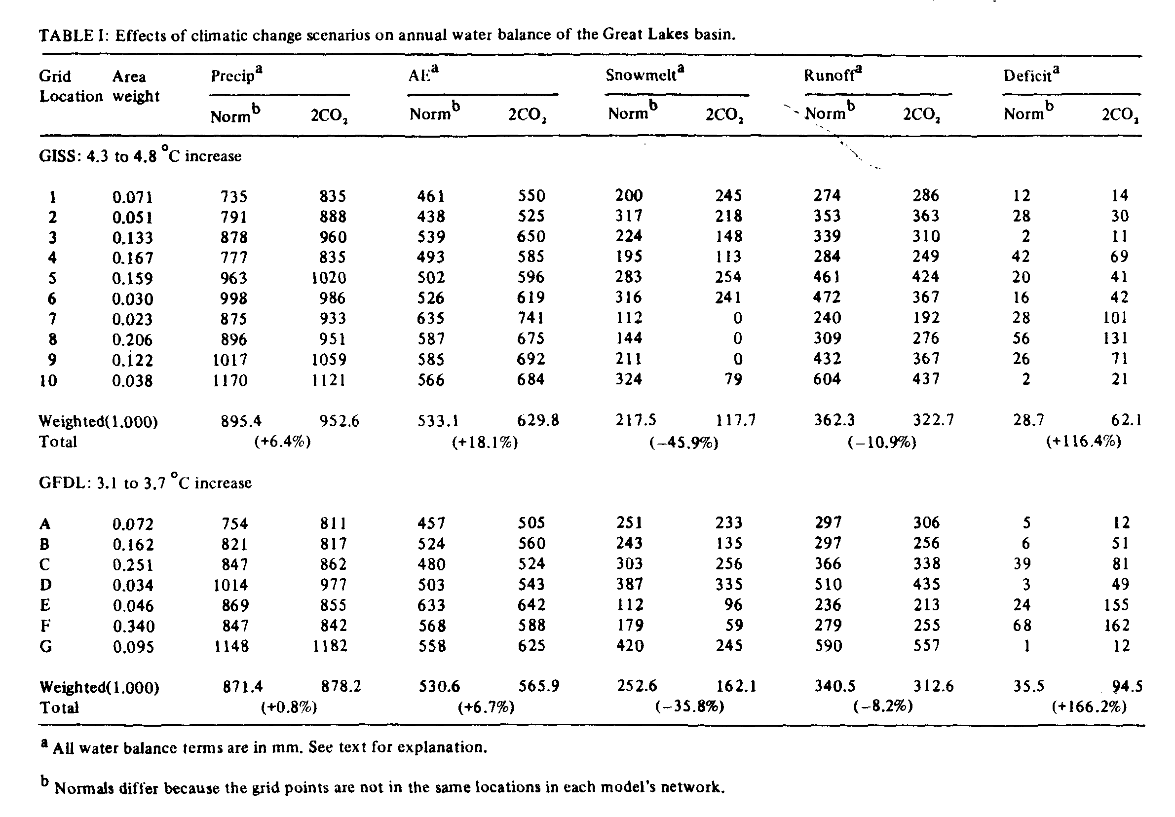
Water balance calculations for the 10-point GISS network and the 7-point GFDL network are shown in Table 1. Both scenarios projected higher temperatures, so potential evapotranspiration would obviously increase. However, according to GFDL, actual land-based evapotranspiration will experience only marginal increases near Lake Michigan and Lake Erie (Points E and F) because of decreased summer precipitation. The GISS scenario differs, projecting little or no change in precipitation in this part of the basin. As a result, GFDL projects a much smaller overall increase in land-based evapotranspiration.
Lower snowmelt is projected in both scenarios since there will be less snow and more rain during the shorter winter season. The GISS scenario projects no snowmelt for southern Lake Michigan and Lake Erie (points 7-9) because all winter months will have temperatures above 0 deg.C.
Annual land-based runoff in the basin is projected to decrease by 10.9% in the GISS scenario, and 8.2% in GFDL. A similar calculation using the eastward shift of GFDL anomalies results in a 10.5% increase. The latter is due to the very large increases in precipitation projected for the Lake Superior area (points 1-2).
Both models project twofold and threefold increases in summer deficits, especially in the southern Lake Michigan and Lake Erie areas. The GFDL deficits are larger because of projected decreases of 10-20% in summer rainfall in the southern third of the region, while little or no change is projected by GISS, as noted above.
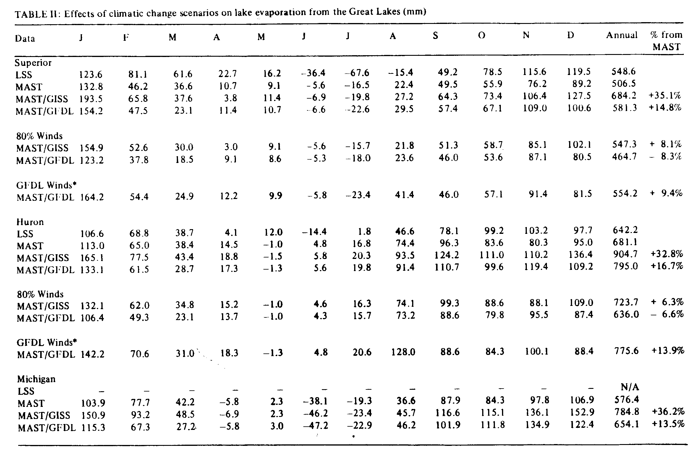
Lake evaporation, based on MAST normals, is projected to increase in both scenarios, if wind speed remains at present mean values (Table 11a11b). For each lake, and for the basin as a whole, the increase is much higher in the GISS scenario because of its higher temperatures. Both scenarios show relatively high rates during the September--January period. Condensation occurs in late spring and early summer at some lakes. Note that the MAST 'normals' are generally lower than evaporation rates based on LSS data. However, the net effect of the climatic change is probably the same.
When the lake evaporation model was run a second time, with wind speeds reduced to 80% of present mean values, evaporation declined to values well below those of the earlier model run. This was expected, given the nature of the mass transfer model. However, GFDL actually projects a decrease in evaporation from present mean values by 7--16%. When GFDL winds are used, the GFDL scenario projects increases of 2-14%. These are smaller than the projected increases of both scenarios using normal winds. Reduced annual wind speeds may indeed prevail in a 2 x CO2 environment because of the anticipated reduction in the equator-pole temperature gradient, but since the GFDL projected changes in individual months show considerable variability, estimates of NBS will proceed using all three model runs.
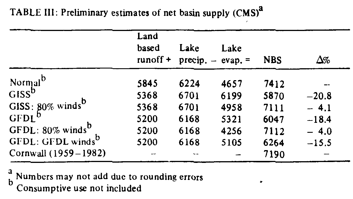
The projected values for land-based runoff and lake evaporation were used to estimate changes in NBS. For this final computation, it was assumed that precipitation over the lake surface was 8% less than over land. This is similar to published field data for Lake Ontario (Wilson and Pollock, 1981, p. 62).
Results are listed in Table III for present normal winds, 80% winds, and GFDL winds (for GFDL only). Long-term mean outflow (1959-1982) from the Great Lakes basin, at Cornwall Ontario, northeast of Lake Ontario, is also indicated for comparison with NBS calculated from normal climate data. Note that the calculation is approximately 3% too high because consumptive use of water has not yet been included. Regarding the scenarios, there are significant differences in NBS between the wind scenarios, but the differences between the two climatic change scenarios are small. Under present normal winds, GFDL projects a decrease in NBS of 18.4%, while a 20.8% decrease is projected by GISS due to the relatively high lake evaporation and the decrease in land-based runoff, both resulting from the higher projected temperatures. If winds are reduced to 80% of present normals, both scenarios project only a 4% decrease in NBS because of the reduction in lake evaporation. Using GFDL winds, GFDL continues to project a lower NBS, but the reduction is 15.5%.
It is important to note that the GISS-projected decreases in NBS have been calculated despite the higher precipitation projected by the scenario. In fact, given the surface area of the Basin, we find that in order to overcome the 20.8% reduction in NBS, we would need an additional 85 mm of precipitation every year.
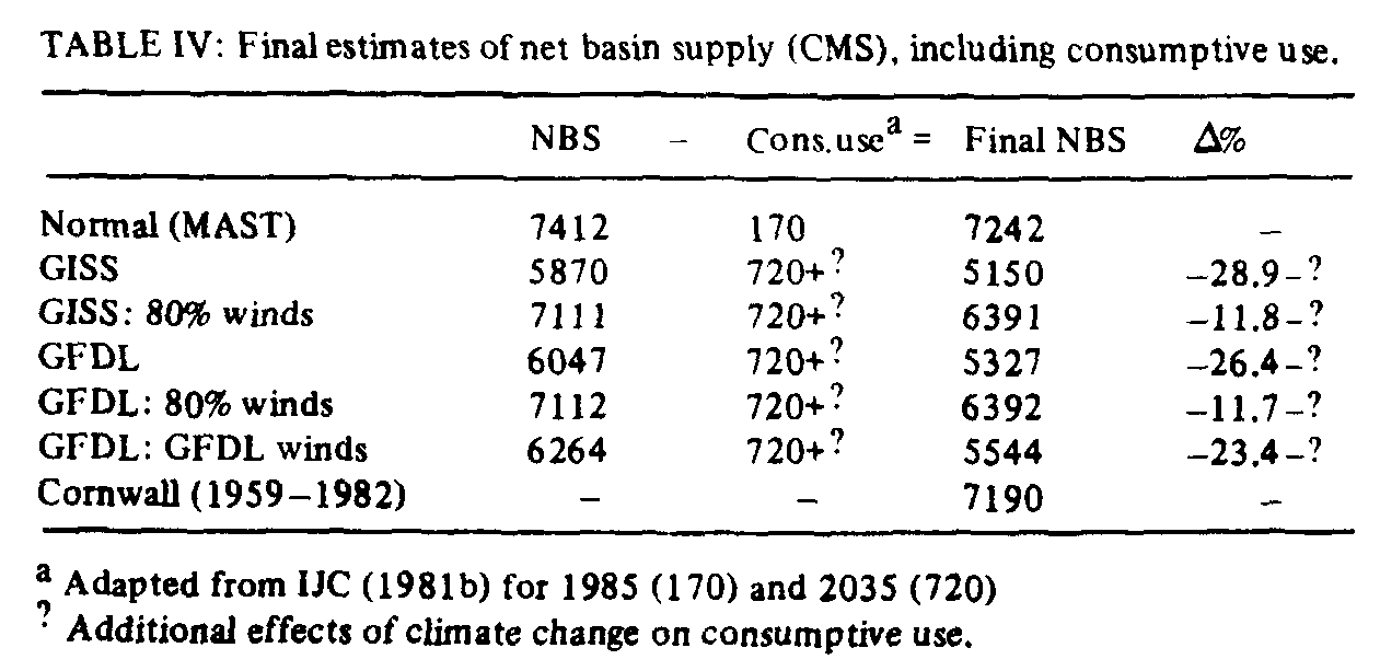
The above calculations project the direct impacts of climatic change on NBS. However, they do not include estimates of water consumption, which will be directly and indirectly affected by climatic change. Table IV shows estimates of NBS if consumptive use is included. For these estimates, data are obtained from the International Joint Commission (IJC,198 1b), for 1985 and 2035. Having accounted for consumptive use, the new estimate for long-term mean NBS becomes 7242 CMS, less than 1% above long-term mean outflow at Cornwall, thereby showing that the approach used in this study can simulate the historical record. The remaining discrepancy might be due to differences in the averaging periods used for discharge and climate data, and the net effect of existing diversions.
Doubling of atmospheric CO2 is expected to occur in 2050--2080 (U.S. NRC, 1982), so consumptive use would probably be higher than the IJC projection for 2035. In any event, increases in use would exacerbate the NBS reductions in GISS and GFDL, and would lead to reductions in all wind scenarios. The IJC projection for 2035 is the 'Most Likely Projection' and is based solely on non-climate factors (population. economic growth, etc.). If the above mentioned increase in summer deficit is considered (from Table 1), consumptive use would have to be higher than projected because irrigation demand, for example, would have to increase. Another sector contributing to this increase would be summer municipal demand, which is positively correlated with summer deficit and temperature in this area (Cohen, 1985). Additional research on the effects of these scenarios on future water consumption is in progress, so as to remove the question marks from this table, and provide a better estimate of NBS in a 2 x CO2 climate.
The two scenarios of climatic change, based on Canadian Climate Centre adaptations (September 1984 version) of the GISS and GFDL model outputs, produce different water balance and lake evaporation estimates. However, estimates of net basin supply (NBS) are similar, with both scenarios indicating substantial decreases. Despite these similarities, there are uncertainties in the estimates, given the wide range of precipitation values obtained from the sensitivity analyses (Section 3). For example, the GFDL-eastward shift would have led to a marginal increase in NBS. These uncertainties will have to be considered when performing climate impact studies of the Great Lakes basin.
The projected decreases in NBS might lead to significant impacts in the region, especially on shipping, hydroelectric power production, recreation, wildlife, and water delivery systems. Any economic activity affected by lake levels would probably experience different impacts under the various wind scenarios, but the general trend is the same for both GISS and GFDL. This is a result of not only the direct effects of climatic change on NBS, but also the indirect effects resulting from probable increases in consumptive use of water within the basin.
There is a pressing need for more research in climatic modelling, so that we can reach a narrower consensus on projections of our future climate, for the purpose of impact assessment. In addition. information is needed on other variables besides monthly temperature and precipitation, especially wind speed, humidity, cloudiness, radiation and heat budget parameters, and presence or absence of snow and ice. These data are probably available, but have not yet been provided for all models. There is also a need for projections of other changes in the 2 x CO2 climate, such as frequencies of extreme events and lengths c f seasons, as well as possible effects of elevated CO2 concentrations on plant transpiration. More research is needed on how to integrate CO2-induced changes in plant processes into the water balance model. In fact, this is part of the larger issue of overcoming the mismatch of scales between global climate models and site-specific response models (Bach, 1984a; Clark, 1985).
Within the context of this and similar impact studies, more detailed analysis of the direct and indirect effects of climatic change on water consumption is required. In the introduction to this paper, a number of linkages were identified (Figure 1), including irrigation demand (agriculture, municipal), energy demand, changes in energy supply modes and resulting implications on cooling requirements at nuclear and fossil fuel power plants. Changes in these activities will have spin-off effects on a wide range of economic endeavours as well as a potentially significant effect on lake levels. Finally, changes that occur within the region will affect economic and political relationships with other regions in matters such as electricity exports from Ontario to the U.S., changes in the shipping season and agricultural productivity, as well as the issue of inter-basin transfer of water from the Great Lakes basin to the southwestern-western U.S. In assessing these and other indirect impacts, the challenge is to initiate serious interdisciplinary research efforts, involving political and social scientists and economists, as well as biological and physical scientists and engineers. Efforts at creating such dialogue have so far met with considerable resistance because of perceptual variations among practitioners in different fields, as well as bureaucratic inertia and lack of resources. Each of these may be symptoms of a general reluctance to seriously study climatic impacts on modem regional economies, because we lack the theoretical underpinnings necessary to do this work. In addition, many people see the variations in projections by the various climate models as a sign that we do not know what the future climate will be like, so we cannot (rather than should not) work on impact assessment now. Researchers in climate impact assessment must communicate their ideas directly with other researchers, and with policy makers in government and industry, particularly by demonstrating an awareness of the breadth of direct and indirect impacts. This, and the refinement of climate models, are necessary prerequisites to the advancement of knowledge in this important field.
This research was performed while the author was a Visiting Research Fellow in the Canadian Climate Centre, Hydrometeorology Division, under the supervision of William Pugsley. My thanks to Henry Hengeveld for providing the scenario data, and to William Pugsley, Henry Hengeveld, Robert Dickinson, and several anonymous reviewers for their comments. The fellowship was administered by the Natural Sciences and Engineering Research Council. The opinions expressed herein are my own, and are not necessarily those of NSERC or Environment Canada.
Ausubel, J. H.: 1983, 'Can We Assess the Impacts of Climatic Changes?' Climatic Change 5, 7-14.
Ausubel, J.H. and Biswas, A.K.,(eds.): 1980, Climate Constraints and Human Activities, International Institute of Applied Systems Analysis Proceedings Series, Vol 10. Pergamon Press, Oxford,
Bach, W.: 1984a, CO2-Scnsitivity Experiments Using General Circulation Models'. Progress in Physical Geography 8, 583 -609.
Bach, W.: 1984b, Our Threatened Climate. Ways of Averting the C02 Problem Through Rational Energy Use, English version translated by J. Jager. D. Reidel Publ. Co., Dordrecht, Holland.
Bach, W., Pankrath, J., and Kellogg, W. (eds.): 1979, 'Man's Impact on Climate', Proceedings of an International Conference In Berlin, June 14-16, 1978, Elsevier Scientific Co., Amsterdam.
Bruce, J. P.: 1984, 'Great Lakes Levels and Flows: Past and Future', Journal of Great Lakes Research 10 (1), 126-134.
Chen, R. S., Boulding, E., and Schneider, S. H. (eds.): 1983, Social Science Research and Climate Change, D. Reidel Publ, CO., Dordrecht, Holland.
Clark, W. C. (ed.): 1982, Carbon Dioxide Review. 1982, Clarendon Press, Oxford. Clark, W. C.: 1985, 'Scales of Climate Impacts', Climatic Change 7, 5-27,
Climate Planning Board: 1979, Carbon dioxide issues and impacts. Proceedings of the Workshop on Energy/Carbon Dioxide Issues and Impacts, Toronto, August 28-29, 1979. Canadian Climate Program, Environment Canada.
Cohen, S. J.: 1985, 'Effects of Climatic Variations on Water Withdrawals in Metropolitan Toronto', Canadian Geographer 29, 113 -122.
DeCooke, B. G., Bulkley, J. W., and Wright, S.J.: 1984, 'Great Lakes Diversions: Preliminary Assessment of Economic Impacts', Canadian Water Resources Journal 9 (1). 1-15.
Glantz, M. H. and Ausubel, J. H.: 1984, The Ogallala Aquifer and Carbon Dioxide: Comparison and Convergence ,Environmental Conservation 11 (2), 123-131.
Idso, S. B.: 1982, Carbon Dioxide: Friend or Foe?, IBR Press, Tempe.
Idso, S. B. and Brazel, A.J.: 1984, "Rising Atmospheric Carbon Dioxide Concentrations May Increase Streamflow', Nature 312, 51-53.
IJC: 1975, Water Supply - Municipal, Industrial, Rural, Appendix 6, in Great Lakes Basin Framework Study. Great Lakes Basin Commission, Ann Arbor,
IJC: 1981a, Main Report. Lake Erie Water Level Study, Report to the IJC by the International Lake Erie Regulation Study Board,
IJC: 1981b, Great Lakes Diversions and Consumptive Uses, Report to the IJC by the International Great Lakes Diversions and Consumptive Uses Study Board.
Jager, J.: 1983, Climate and Energy Systems: A Review of their Interactions, John Wiley and Sons, Chichester.
Johnstone, K.J. and Louie, P. Y. T.: 1984, An Operational Water Budget for Climate Monitoring, Unpublished manuscript, Canadian Climate Centre Report No. 84-3. Available from the Canadian Climate Centre, Downsview, Ontario.
Kates, R. W., Ausubel, J.H., and M. Berberian (eds.): Climate Impact Assessment: Studies of the Interaction of Climate and Society. John Wiley and Sons, Chichester. (forthcoming).
Kellogg, W. W. and Schware, R.: 1981, Climate Change and Society, Aspen Institute for Humanistic Studies, Westview Press, Boulder.
Mather, J.: 1978, The Climatic Water Balance in Environmental Analysis, Lexington Books, Lexington, MA .
Miller, J. R. (ed.): 1980. Prospects for Man: Climatic Change, Centre for Research on Environmental Quality, York University, Downsview, Ontario.
Ontario Hydro: 1984, The Carbon Dioxide Issue - An Ontario Hydro Perspective, Environmental Studies and Assessments Department Report No. 84003, May.
Palutikof, J. P., Wigley, T. M. L., and Lough, J. M.: 1984, Seasonal Climate Scenarios for Europe and North America in a High-CO2, Warmer World. U.S. Dept, of Energy, TR012, DOE/EV/10098-5, August. Available from National Technical Information Service, U.S. Dept. of Commerce, Springfield, VA.
Quinn, F. H. and den Hartog, G.: 1981, Evaporation Synthesis', in E. J. Aubert and T. L. Richards (eds.), IFYGL - The International Field Year for the Great Lakes, U.S. Dept. of Commerce, Ann Arbor, p. 221-245.
Richards, T. L. and Irbe, J. C.: 1969, 'Estimates of Monthly Evaporation Losses from the Great Lakes 1950 to 1968 Based on the Mass Transfer Technique', Proceedings Twelfth Conference on Great Lakes Research, International Association of Great Lakes Research, pp. 469 -487.
Sewell, W. R. D., MacDonald-McGee, D., and Locke, W.: 1984, Climate Variability and Change in Canada: Towards an Acceleration of the Social Science Research Effort, Unpublished manuscript, Canadian Climate Centre Report No. 84-12. Available from the Canadian Climate Centre, Downsview, Ontario.
Slater, L. E. and Levin, S. K. (eds.): 1981, Climate's Impact on Food Supplies, American Association for the Advancement of Science Selected Symposium 62, Westview Press, Boulder.
Thornes, J. E.: 1981, 'A Paradigmatic Shift in Atmospheric Studies?' Progress in Physical Geography 5, 3,429-440.
U.S. DOE: 1983, Response of the North American Corn Belt to Climatic Warming. TR006, DOE/NBB-00404, Available from National Technical Information Service, U.S. Dept. of Commerce, Springfield, VA.
U.S. EPA: 1983, Can we Delay a Greenhouse Warming? Strategic Studies Staff, Office of Policy Analysis, September.
U.S. EPA: 1984, Potential Climatic Impacts of Increasing Atmospheric CO2 with Emphasis on Water Availability and Hydrology in the United States. Strategic Studies Staff, Office of Policy Analysis, April.
U.S. NRC: 1982, Carbon Dioxide and Climate A Second Assessment. National Academy Press, Washington,
Wilson, J. W. and Pollock, D. M.: 1981, 'Precipitation', in Aubert, E. J. and Richards, T. L. (eds.), IFYGL - The International 'Field Year for the Great Lakes, U.S . Dept. of Commerce, Ann Arbor.
WMO: 1981, Joint WMO/ICSU/UNEP meeting on the Assessment of the Role of CO, on Climate Variations and their Impact, Joint Planning Staff, WMO, Geneva.