|
|
Extensive Guide to Night-time Light Data Now Available
|
|
December 19, 2008
|
Night-time light imagery from remote sensing data sources offers a uniquely
“human” view of the Earth’s surface, as it is due almost entirely to some form
of human activity. This illustrated guide introduces users to the types of
night-time light data available, the characteristics, and the limitations. The
second part of the guide examines how the data source has been and may be used
to derive useful information about human presence and activities on Earth.
Topics range from population and light pollution to economic activity,
greenhouse gas emissions, and using night-time lights to help with disaster
management. The ecological ramifications of night-time lighting are also
considered. The final section of the guide explores other potential sources of
night-time light data and how future systems may enhance existing capabilities
for understanding the human environment through the observation of lights at
night. The Guide was developed by former Earth Institute Fellow Christopher
Doll, with support from the NASA Socioeconomic Data and Applications Center
(SEDAC) operated by CIESIN.
See: Night-time Light Remote Sensing and Its Applications Web site
|
|
Geoscience Data Interoperability and Stewardship Discussed at Annual AGU Meeting
|
|
December 18, 2008
The annual fall meeting of the American Geophysical Union (AGU) in San Francisco held December 15–19 was the venue for high-level discussion of collaboration between libraries and data centers on digital data preservation, and of recent institutional and technical improvements in interoperability between different types and sources of geoscience data. In a prominent Union Session on the Library-Data Center Alliance in Earth and Space Sciences held December 15, Columbia University vice president for Information Services and University Librarian James Neal gave an invited presentation on the central role of libraries in long-term stewardship of digital scientific data, information, and ultimately, knowledge. In a follow-up session December 16, a poster on CIESIN´s collaboration with the Columbia Libraries developing a long-term digital data archive was presented, authored by CIESIN senior digital archivist Robert Downs, CIESIN director Robert Chen, and library staff members Robert Cartolano and Rajendra Bose. On December 17, Chen gave an oral presentation on proposed implementation guidelines for the data sharing principles of the Global Earth Observing System of Systems (GEOSS), focusing on how the geoscience community can promote institutional cooperation in data sharing. Downs was co-convener of the poster session, Challenges for Earth Science Software Reuse, offered December 15, and was a co-author, with James J. Marshall, Lawrence J. Gilliam, and Robert E. Wolfe, of another poster presented during the session on reuse.
See: “Collaborative Establishment of a Long-Term Archive...”
“Progress in the Development of a Prototype Reuse Enablement System”
CU Press Release
|
|
Interactive Mapper Will Aid Student Exploration of Hudson River Watershed
|
|
December 14, 2008
CIESIN associate director for Geospatial Applications, Mark Becker, and geographic information specialist, Kytt MacManus, presented a preview of the forthcoming Hudson River Watershed Mapping Application at the grand opening of the Beacon Institute Center for Environmental Innovation and Education (CEIE). The event took place December 12 in Denning’s Point State Park in Beacon, New York. The application, a project of the National Biological Information Infrastructure Northeast Information Node (NBII-NIN), is being developed as part of a school curriculum focused on the Hudson River Watershed. The Mapper will display many of the social, physical, regulatory, and environmental features of the area in order to engage school-age children to interactively explore both the watershed itself and the communities that depend on it. Future iterations of the application will make use of data from the River and Estuary Observation Network (REON), a joint effort between the Beacon Institute and IBM. Currently in the process of being deployed, REON is a first-of-its-kind sensor network able to capture physical, chemical, and biological information in real time. It can then sort that information and visualize the resulting data. The Hudson River Watershed Mapping Application will act as a central forum for the presentation of REON data in education, and to the general public.
See: Beacon Institute/CEIE Web site
|
|
The Role of Spatial Data in Addressing Meningitis Outbreaks
|
|
December 7, 2008
Associate director for Geospatial Applications, Mark Becker, represented
CIESIN at the Meningitis Environmental Risk Information Technologies (MERIT)
meeting held in Addis Ababa, Ethiopia December 1–3. The meeting featured
representatives from the
IRI, the
World Health Organization, the
University Corporation for Atmospheric
Research, and health ministries from countries throughout Africa. The
meeting’s purpose was to look at ways to use information from climate forecast
models to better understand onset of meningitis outbreaks, and to use this
knowledge to design better vaccination programs. Becker demonstrated how CIESIN
data products might play a role in the process, using as examples CIESIN’s
poverty mapping studies
and its Global Rural Urban Mapping Project
(GRUMP), which gives
insights into urban population distribution and the global extents of human
settlements.
|
|
Remote Sensing and the Law at UK Workshop
|
|
December 6, 2008
The use of remote sensing in the context of environmental policy and law
enforcement was examined at a University College London (UCL) workshop at which
CIESIN senior research associate Alex de Sherbinin presented a paper, “Remote
Sensing in Support of Multilateral Environmental Agreements.” The workshop, held
December 5, brought together remote sensing researchers, policy experts, and
judges from Europe and the United States, including CIESIN fellow and former
director, Roberta Balstad, who also chaired a session of the workshop.
See: UCL Centre for Law & the Environment Web site
|
|
“Radical Sharing” of Digital Data the Focus of Edinburgh Conference
|
|
December 4, 2008
“Radical Sharing: Transforming Science” was the theme of the 4th
International Digital Curation Conference held December 1–3 in Edinburgh,
Scotland. The term “radical sharing” refers to possible new ways of doing
science using such approaches as large-scale research networks, mass
collaboration, dynamic publishing tools, wikis, blogs, social networks, and
visualizations and immersive environments. CIESIN director Robert Chen helped
kick off the discussion as moderator of the opening plenary session on the
conference theme, which included papers on new e-Science approaches in ecology,
neuroscience, and biomolecular sciences.
The UK Digital Curation Centre
(DCC) supports UK institutions that
store, manage, and preserve scientific data, helping to ensure their enhancement
and their continuing long-term use. The DCC has recently become the UK member
organization of CODATA, the ICSU Committee
on Data for Science and Technology.
See: 4th International Digital Curation Conference
|
|
How Climate Change May Affect World Security Discussed at SUNY-New Paltz
|
|
December 3, 2008
|
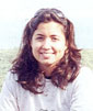
|
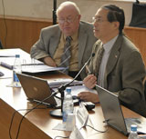
Source: Karl Rabe/Poughkeepsie Journal
Marc Levy at the State University of New York at New Paltz December 2,
speaking on links between climate and world security.
|
CIESIN deputy director Marc Levy was at the State University of New York, New
Paltz, the evening of December 2 to speak about climate change and world
security. The event was sponsored by the
Center for Research, Regional Education
and Outreach; the World
Affairs Council of the Mid-Hudson Valley; and the
Gillespie Forum. Pointing to
CIESIN-made maps of socioeconomic and environmental data to visualize his
subject, Levy noted that the erratic nature of climate change made it easy to
disrupt the delicate balance for populations already living in vulnerable
situations, and possibly give rise to conflict. He said that Sudan’s Darfur
conflict coincided with the nation’s most serious drought in centuries. He also
discussed security pressures arising from water scarcity and the emergence of
new infectious diseases, both of which can be exacerbated by climate change. An
organization similar to the International Monetary Fund should be set up, Levy
said, in order to monitor and respond to the environmental impacts on human
security.
See: Full Story
SUNY-New Paltz Article
|
|
Potential Links Between Cardiovascular Disease and Urbanization Examined
|
|
November 24, 2008
CIESIN hosted a two-day workshop for the Earth Institute Cross-Cutting
Initiative on Cardiovascular Disease (CVD) and Urbanization in Modern China,
November 20–21. This study is led by Andrew Moran, assistant professor of
medicine at Columbia University’s College of Physicians and Surgeons, and Susana
Adamo, associate research scientist with the Science Applications Division at
CIESIN. The project involves the development of a computer model that simulates
rural to urban migration, and the national-scale health consequences among
permanent urban migrants of changing to higher calorie-, higher fat-diet, and to
lower physical activity. CIESIN is providing data and methodological expertise
on the spatial distribution of populations, and thus changes in the population
CVD risk, in light of North-South, rural-urban, and urban-urban migration
trends.
|
|
IPCC Task Group Addresses Observed Climate Impact Studies
|
|
November 21, 2008
The headquarters of the World Meteorological Organization in Geneva,
Switzerland was the venue for the 15th meeting of the Task Group on
Data and Scenario Support for Impact and Climate Analysis
(TGICA) of the
Intergovernmental Panel on Climate Change
(IPCC) on November 19-21. CIESIN director
Robert Chen attended the meeting in his capacity as co-manager of the IPCC Data
Distribution Center (DDC).
CIESIN senior staff associate Xiaoshi Xing also participated. Chen and Xing
reported on recent work to make available a database on observed climate change
impacts, developed by an international team co-led by Cynthia Rosenzweig of
NASA’s Goddard Institute for Space Studies
(GISS), and to develop a new system to
encourage submission of new observed impact studies in support of the fifth IPCC
assessment. They also contributed to a set of recommendations about the next
phase of the TGICA’s work, which will be reconstituted by the new IPCC Bureau in
2009.
See: IPCC Socioeconomic Data Distribution Centre Web site
|
|
Group on Earth Observations Reviews Data Sharing Approaches in Bucharest
|
|
November 19, 2008
At the fifth plenary meeting of the Group on Earth Observations (GEO-V) in
Bucharest, Romania, a proposed set of data sharing guidelines were reviewed and
discussed in a special side event held November 18 co-chaired by CIESIN director
Robert Chen and prof. Joanne Irene Gabrynowicz of the
University of Mississippi and the
International Institute for Space Law
(IISL).
GEO, a major
international initiative to develop and implement a Global Earth Observing
System of Systems
(GEOSS), adopted a
strong set of data sharing principles in 2005.
CODATA, the Committee on Data for Science
and Technology of the International Council for Science
(ICSU), accepted lead responsibility
for developing a white paper and proposed guidelines for implementing these
principles.
The side event, held in the Romanian Parliament building, drew more than 30
representatives of GEO members and participating organizations. Chen provided an
overview of the current status of the data sharing guidelines and a tentative
timeline for potential acceptance of the guidelines at the next GEO Ministerial
meeting in 2010. Gabrynowicz moderated a panel of experts drawn from several of
the GEO cross-cutting committees. She also presented a progress report on data
sharing in the Plenary session on November 19.
See: GEO Data Sharing Principles Implementation
GEO-V plenary
|
|
Simulation Exercise for NDU Workshop Addresses New Environment-Security Linkages
|
|
November 14, 2008
|
|
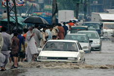
Source: IRIN
Photo of flooding in Lahore, Pakistan. It was used in one of several
simulation scenarios created by CIESIN as part of a day-long exercise for a
workshop in Prague October 11-14 on new environment-security linkages.
|
Governments are increasingly concerned about non-traditional security threats
such as climate change, water scarcity, population movement, and emerging
infectious disease epidemics. These threats were the focus of the National
Defense University's (NDU) Near East and
South Asia Center for Strategic Studies Senior Executive Alumni Symposium
held in Prague from October 11 through October 14. The symposium was attended by
twenty-five high ranking diplomats and military officials from eleven countries.
CIESIN designed and facilitated a one-day simulation exercise in order to
expose symposium participants to the complex set of security challenges such
events might pose. A series of mock news broadcasts confronted participants with
a range of cascading emergencies including a sharp spike in food prices, severe
flooding, and the outbreak of a highly contagious new disease. Drawing on its
core competence in environmental data integration and visualization, CIESIN
developed several regional maps highlighting possible migration routes, disaster
vulnerability, and potential spread of the disease outbreak. The simulation
allowed participants to reflect on their countries’ preparedness levels and to
share management techniques learned from previous emergencies.
The mock news broadcast was produced by CIESIN in collaboration with
Columbia University School of
Journalism and
Modern Metro
Studios. This simulation can be run in multiple workshop formats and for
longer durations, and is one of a number of educational and training exercises
on environment and security linkages currently under development at CIESIN.
|
|
User Working Group Assesses Data Needs
|
|
November 13, 2008
CIESIN convened members of the User Working Group (UWG) for the NASA
Socioeconomic Data and Applications Center (SEDAC) for a meeting in New York
November 13-14 to advise SEDAC on the most pressing needs for new integrated
data products, improved data tools and services, and user training and capacity
building. Key areas of discussion included the need for more detailed
demographic data in gridded forms to support interdisciplinary research and
applications and for expanded data and services useful for assessing
vulnerability and adaptation to climate change.
On November 13, the UWG discussed African data needs with Pedro Sanchez, head
of the Earth Institute's Tropical Agriculture and Rural Environment Program, and
reviewed SEDAC's efforts in support of the Intergovernmental Panel on Climate
Change (IPCC) Data Distribution Center (DDC) and the planned Global Earth
Observing System of Systems (GEOSS). UWG members Chris Elvidge of NOAA’s
National Geophysical Data Center and Dale Quattrochi of NASA's Marshall Space
Flight Center gave updates on two proposed satellite missions that could
significantly improve observations of human-environment interactions. On
November 14, the UWG met with James Neal, Columbia’s vice president for
Information Services and university librarian, to discuss SEDAC's interactions
with the Libraries on long-term digital data stewardship.
The UWG is led by Prof. Harlan Onsrud of the University of Maine and includes
leading experts from the social, natural, health, and information sciences.
Several representatives from NASA also participated in the meeting.
See: SEDAC User Working Group
|
|
Weather, Climate, and Impacts Workshop Focuses on Integration of Socioeconomic Data
|
|
October 30, 2008
The use of socioeconomic data for research into climate change impacts, vulnerability, and adaptation assessment was the subject of a presentation given by CIESIN senior staff Associate Alex de Sherbinin at the 3rd NCAR Community Workshop on GIS in Weather, Climate, and Impacts. The workshop, held October 27-29 in Boulder, Colorado, focused on the integration of socioeconomic data with weather and climate data via GIS applications. It brought together 65 experts from the climate, meteorological, GIS, and social science communities.
See: NCAR Weather, Climate, and Impacts Workshop
Socioeconomic Data for Climate Change Impacts Presentation
|
|
CIESIN Digital Archivist Honored for Software Re-Use Efforts
|
|
October 23, 2008
CIESIN senior digital archivist Robert R. Downs has received the 2008
Peer-Recognition Software Reuse award, given by the NASA
ESDS Software Reuse Working
Group during the 7th Joint Earth Science
Data Systems Working Group Meeting held October 21–23 in Philadelphia. The
award was made in the category of Peer-Education, in recognition of Downs’
contributions to education and public outreach on the reuse of software by the
Earth science data community. Downs has co-authored numerous papers on the
subject; contributed to studies, documentation, and development of protocols;
and participated actively in all stages of development of the working group’s
Web site.
See: 2008 Peer Recognition Award Recipients
|
|
NSF Awards Research into Human Factors Affecting Emerging Infectious Diseases
|
|
October 20, 2008
Research into the human factors that affect emerging infectious diseases
(EIDs) will continue as part of a new four-year award to CIESIN and the
Consortium for Conservation Medicine
(CCM), from the National
Science Foundation’s Human and Social Dynamics program (award
0826840).
This interdisciplinary study will integrate global-scale socioeconomic and
environmental data sets with biogeographic data on wildlife, human and livestock
populations, and pathogen distributions. The integrated data collection will be
used as a basis for developing spatial mathematical models to identify and
predict areas with high potential for disease emergence at local scales and for
pandemic (global) spread. CIESIN’s project will be led by deputy director Marc
Levy and associate research scientist Susana Adamo. This project represents a
deepening of the collaboration with CCM, where the team is led by Peter Daszak,
building on an exploratory NSF grant
(award
0525130) to the two organizations. The first study established that EIDs are
on the rise and that zoonoses—diseases from wildlife—are the prime threat; the
February 2008
publication in Nature summarized those results.
See: Human-Related Factors Affecting Emerging Infectious Diseases (Abstract)
|
|
CIESIN Director Re-elected as CODATA Secretary-General
|
|
October 13, 2008
|
|
Source: KPI
CODATA’s newly re-elected secretary general, Robert Chen (right), with Gordon
Wood, CODATA vice president.
|
CIESIN director Robert Chen was re-elected to a second four-year term as
secretary general of CODATA, the Committee
on Data for Science and Technology of the International Council for Science
(ICSU), at the organization’s 26th
General Assembly in Kyiv, Ukraine October 9–10. A major role of the CODATA
secretary general is oversight of the activities of CODATA’s Secretariat, which
is based at the ICSU offices in Paris. The secretary general also helps to
manage CODATA task groups and working groups, which tap experts from around the
world to tackle pressing scientific data issues across a wide range of
disciplines. During his initial term, Chen led the development of a strategic
plan for CODATA and coordinated its efforts to develop implementation guidelines
for the Data Sharing Principles of the planned Global Earth Observing System of
Systems (GEOSS).
In conjunction with the General Assembly, Chen also participated actively in
the 21st CODATA Conference, which drew some 500 scientists and students to the
campus of Kyiv Polytechnic
Institute for more than five days of workshops and symposia. He presented
papers on CIESIN’s recent work on the International Polar Year
(IPY) and GEOSS and on a long-term data
archive, and reported on the GEOSS data policy task and the CODATA Global Roads
Data Working Group. He also chaired a session on natural disaster data and a
round-table discussion on CODATA’s collaboration with other ICSU bodies
concerned with Earth and environmental data.
See: CODATA Web site
CODATA GEOSS paper (PDF 388 KB)
CODATA2008 WDC paper (PDF 2.51 MB)
Creating A Trustworthy Digital Repository paper (PDF 838 KB)
Global Roads Data presentation (PDF 486 KB)
|
|
Observed Climate Change Impacts Discussed at Beijing Colloquium
|
|
October 8, 2008
|
|
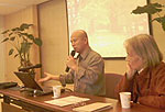
Xiaoshi Xing, with Chunzhen Liu, conducts a colloquium on observed climate
change impacts.
|
Xiaoshi Xing, information scientist at CIESIN, together with Chunzhen Liu, a
lead author of the Fourth Assessment Report (AR4) of the Intergovernmental Panel
on Climate Change (IPCC), conducted a
colloquium in Beijing October 8 on the IPCC Data Distribution Centre
(DDC). The colloquium, which
took place at the Water Resource Research Center of the Chinese Academy of
Sciences (CAS), focused on observed climate
change impacts. Xing described the development of the IPCC observed impacts
database and plans for its expansion. Also discussed was a possible workshop on
observed impacts at a global or regional level in 2009. About 60 scientists,
researchers, and students from diverse backgrounds attended the meeting and
engaged in a question-and-answer period with the presenters.
The IPCC DDC is a shared data management operation between the NASA
Socioeconomic Data and Applications Center
(SEDAC) operated by CIESIN; the
UK’s British Atmospheric Data
Centre; and the World Data
Center Climate at the Max Planck Institute for Meteorology in Hamburg,
Germany. SEDAC’s section of the DDC provides online access to observed impacts
and baseline and scenario data on population, economic development, technology,
and natural resources for climate impact assessments.
See: IPCC
IPC DDC
|
|
2008 CODATA Prize Awarded to CIESIN Alumna
|
|
October 8, 2008
|
|
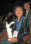
Dr. Liu Chuang receives the 2008 CODATA Prize, symbolized by a reproduction
of the Louvre's Winged Victory of Samothrace.
|
The 2008 CODATA Prize was awarded to Dr. Liu Chuang of the Chinese Academy of
Sciences at the 21st CODATA Conference in Kyiv, Ukraine. The CODATA Prize is
given out every other year in recognition of outstanding achievements in the
development of data science.
Dr. Liu was recognized for her significant efforts over two decades to open
up data access in China, promote data access and capacity building in developing
countries, and develop new scientific data products on land use and land cover
change. She led the development of the Global Alliance for Enhancing Access to
and Application of Scientific Data in Developing Countries
(e-SDDC) under the umbrella of the United
Nations Global Alliance for ICT and Development
(GAID). She played a lead role in the
expansion of the World Data Center
System in China and was instrumental in the adoption of open data access
policies by the Ministry of Science and Technology of China
(MOST). She continues to serve as user
co-chair of the Working Group on Information Systems and Services
(WGISS) of the Committee on Earth Observing
Systems (CEOS) and to contribute to other
international data initiatives, including CODATA’s Task Group on Preservation
and Access to Scientific and Technological Data in Developing Countries, which
she co-chaired for the past six years.
Dr. Liu was a staff scientist with CIESIN from 1994 to 1998, where she had
lead responsibility for developing CIESIN’s widely-used
China Dimensions data
collection. When CIESIN relocated to Columbia University in 1998, she returned
to China to join the Institute of Geography and Natural Resources Research of
the Chinese Academy of Sciences (CAS).
Previous winners of the CODATA Prize include Dr. John Rumble, former CODATA
President and former director of the Standard Reference Data Program at the
National Institute of Standards and Technology
(NIST), and Prof. Jean Bonnin of the
Institute of Physics of the Earth in Strasbourg, France. CODATA is an
interdisciplinary committee of the
ICSU, with the mission to strengthen
international science for the benefit of society by promoting improved
scientific and technical data management and use.
|
|
Land Use Change and Changing Climate the Topic at Berlin Conference
|
|
October 4, 2008
Deputy director Marc Levy and postdoctoral fellow Sandra Baptista
participated in a conference, Tough Choices: Land Use Change Under a Changing
Climate, held October 2–3 in Berlin and sponsored by the U.S. National Science
Foundation, German Research Foundation, and German Federal Ministry of Education
and Research. Levy gave a keynote address, “Ecosystem Service Tradeoffs: Global
Examples Involving Biodiversity Conservation, Poverty Reduction and Disease
Prevention,” which presented the results of two recent research projects that
shed light on the nature of difficult tradeoffs among competing ecosystem
services. He summarized the findings of a study looking at the relationship
between the distribution of human poverty and biodiversity, and of a study
identifying driving forces (one of which is biodiversity) of emerging infectious
diseases. Both studies illustrated the need for more sophisticated approaches to
understanding and managing tradeoffs.
Baptista presented a poster, “Climate Hazards and Adaptation to Climate
Change in Metropolitan Florianópolis.” The poster details a case study of land
use decision making and institutional adaptation to climate variability and
change at the local/regional scale in metropolitan Florianópolis, which is
situated in the low elevation coastal zone of Santa Catarina State. The study
explores how knowledge of local institutions (and their multiscale social and
land use contexts) can support cross-site comparisons and can contribute to
analyses at broader spatial and organizational scales.
See: Climate Hazards Poster
|
|
CIESIN Participates in ’Sustainable Science’ Open House
|
|
October 3, 2008
CIESIN will highlight its work on the impacts of climate change,
vulnerability to natural disasters, and the sustainability of the Hudson River
Watershed, as part of the theme, “Science to Sustain the Planet,” at the annual
Lamont-Doherty Earth Observatory Open House, Saturday, October 4 from 10am to
4pm. The entire Lamont campus will be host to a projected turnout of more than
4,000 teachers, students, parents, and members of the general public from the
greater New York metropolitan area. The Open House was started soon after
Lamont’s inception in 1949 to communicate current developments in the Earth
sciences to the public, and how increased understanding of the Earth helps
preserve its future. CIESIN has participated in the Open House annually since
1998. This year CIESIN will feature a new Web portal and interactive mapping
tool for the Hudson River watershed, as well as a quiz for students.
See: Open House at LDEO
|
|
Visiting Scholar Will Focus on Remote Sensing and Image Technologies in Roads and Related Research
|
|
October 1, 2008
Tan Kun, a graduate student in the School of Environmental Science and
Spatial Informatics from the China University of Mining and Technology, will
spend about a year in residence as a visiting scholar at CIESIN. Mr. Tan will be
working with CIESIN staff to use remote sensing data and image processing
techniques to identify and characterize intercity roads and related
infrastructure. Accurate data on roads are especially poor in developing
countries, but important for both research and applications in a variety of
fields such as disaster management, conservation, public health, and
development.
|
|
Environmental Performance Assessment Development Meetings in Beijing
|
|
September 29, 2008
CIESIN deputy director Marc Levy and senior staff associate Alex de Sherbinin
traveled to Beijing for meetings to develop a provincial-level Environmental
Performance Index (EPI). The meetings, held September 27 and 28, included an
international workshop on environmental performance assessment and side meetings
with colleagues from Yale University, with whom CIESIN developed the global
EPI; and counterparts at
the Chinese Academy of Environmental Planning, a division of the Ministry of
Environmental Protection.
|
|
CIESIN Staff Address Drought-Health Links, Digital Preservation, and Data Interoperability
|
|
September 26, 2008
Recent activities by CIESIN staff include participation by senior staff
associate Meredith Golden in a consultancy forum,“The Public Health Impacts of
Drought: Guidance for State, Local, and Tribal Health Departments,” that was
held in Atlanta September 17–19. Sponsored by the
NCEH at the CDC in partnership with the
EPA, the
AWWA, and the
NOAA, the forum gathered together more than
30 national experts from a wide range of organizations. Participants offered
information and best practices for the development of a guidance document to
address the public health impacts of drought.
CIESIN senior digital archivist Robert R. Downs presented a paper co-authored
with CIESIN director Robert Chen, “Exploring Collaborative Models for
Sustainable Governance of Digital Collections of Scientific Data,” at
DAPS ‘08 workshop
held September 22 in Baltimore, Maryland. The workshop was given in conjunction
with the MSST2008 and supported by
the NSF. Later in the week, Chen and
geographic information specialist Greg Yetman participated in two meetings
concerned with international sharing of remote sensing and other spatial data,
held in Boulder September 22–26. In his capacity as secretary-general of the
CODATA, Chen presented an update on the
development of implementation guidelines for the Data Sharing Principles to the
GEO Architecture and Data
Committee. Yetman then participated in the kickoff workshop for the second phase
of the GEOSS Architecture Implementation
Pilot (AIP-2), which will demonstrate interoperability between different data
systems, analytic services, map clients, and portals. CIESIN plans to provide
both data and client services to the pilot effort.
See: GEOSS Workshop Information
|
|
The Role of Natural Resource Management in Peacebuilding Discussed at NYC Forum
|
|
September 19, 2008
Deputy director Marc Levy participated in a joint forum, “Managing Natural
Resources in Post-Conflict Societies: Lessons in Making the Transition to
Peace.” The two-day forum, held at Columbia University on September 17-18, was
part of a research project involving the
Environmental Law Institute, the UN
Environment Programme (UNEP), the
University of Tokyo, and the
World Conservation Union. The project seeks
to understand how effective natural resource management can assist in
peacebuilding. Levy is a member of the project advisory committee and is writing
a paper with former CIESIN post-doctoral scholar Christian Webersik, now at the
United Nations University in Yokohama, Japan.
CIESIN researchers Sandra Baptista, Lauren Berry, and Alex Fischer also
participated in the forum. CIESIN served as local host for the forum as part of
a broader partnership between UNEP’s
Post-Conflict and Natural Disaster
Management Branch and the Earth Institute. Within that partnership CIESIN is
working with UNEP on graduate training curriculum development, student
internships, and other initiatives.
See: Meeting report
|
|
Integrating Spatial Data: Hands-on Workshop Offered in Brazil
|
|
September 18, 2008
|
|
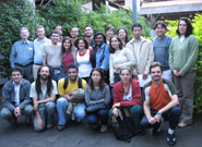
Staff and students from Brazil's University of Campinas pose with Alex de
Sherbinin (back row, 2nd from left) and Susana Adamo (back row, 4th from right).
|
CIESIN senior staff associate Alex de Sherbinin and associate research
scientist Susana Adamo travelled to the University of Campinas (Unicamp) in São
Paulo state, Brazil to lead a workshop on spatial data integration September
15-17. The workshop was offered to a group of staff members and graduate
students at the university’s Population Studies Unit
(NEPO). A
variety of data integration methods developed by CIESIN were presented,
accompanied by hands-on training exercises using ArcMap and Geoda software
packages.
Unicamp is one of the public universities of São Paulo. Created in 1962, its
original aim was to promote science education. Unicamp is now responsible for
about 15% of all Brazilian research.
See: University of Campinas
NEPO
|
|
Species Data Reveal Areas of High Biodiversity in the Americas, the World
|
|
September 12, 2008

|
Human activities have contributed to habitat loss for a large number of
species worldwide. In response, species mapping has become an increasingly
important tool for conservation priority-setting and ecological modeling. Now a
consortium of conservation
organizations—NatureServe,
IUCN,
Conservation
International, and World Wildlife
Fund-USA—has developed a vast digital library of the distribution of birds
and mammals of the Americas and amphibians of the world. To make these data more
useful for a wide range of applications, CIESIN’s NASA-funded Socioeconomic Data
and Applications Center (SEDAC)
converted the entire collection of shapefiles to raster format at 1-km grid-cell
resolution. Basic or advanced searches may be undertaken for species in each of
the three classes—amphibia, aves, and mammalia—using any number of criteria
including class, family, genus, and endangerment status according to the IUCN
Red List. Users may download the search results as zip files, with a readme file
explaining how to use the data and a full metadata record of each of the data
sets bundled in the file. The Web site provides the original vector data (in
ESRI shape file format), the original grids (a raster version of the vector
data), and presence grids (raster data depicting the presence or absence for
each species). The grids are distributed in GeoTIFF format. In addition, SEDAC
has created “richness grids” that describe the number of species by class and
family found in each grid cell. Data sets include:
- 5,810 species of amphibia
- 4,166 species of aves
- 1,716 species of mammalia
Users may download maps showing species richness at continental and global
scales for each of the three classes.
See: Species Distribution Grids Web site
|
|
New Post-Doc Joins CIESIN, To Study Social and Environmental Change
|
|
September 10, 2008
Sandra Baptista, a new Earth Institute postdoctoral fellow, has begun a
two-year appointment at CIESIN. Baptista plans to expand on her doctoral
research on demographic change, urbanization, vegetation dynamics, and
environmental governance in southern Brazil, including the examination of
vulnerabilities and adaptation to climate change in Brazil’s coastal
city-regions. She will also provide scientific expertise on the integration of
social science, ecological, and remote sensing data to the NASA Socioeconomic
Data and Applications Center (SEDAC) hosted by CIESIN. Her master’s and PhD
degrees are in geography from Rutgers, The State University of New Jersey; and
she received an interdisciplinary bachelor’s degree in environmental studies and
Portuguese and Brazilian studies from Brown University.
|
|
Designing a 'Data Commons' for Sustainability Science Discussed at Havana Workshop
|
|
September 4, 2008
CIESIN senior staff associate Alex de Sherbinin gave a presentation,
“Designing A Data Commons for Sustainability Science: Lessons Learned from a
World Data Center,” at the InterAcademy Panel
Workshop
on Open Access to Scientific Literature and Other Digital Scientific Information
Resources in Central America and the Caribbean offered September 3–4 in Havana,
Cuba. The workshop focused on providing greater access to scientific information
and data over the Internet in ways that benefit sustainable development.
Representatives from the Cuban Academy of Sciences and other academies in the
region were present, together with representatives of the Science Commons and
other international participants in the growing area of the “information
commons.”
See: Presentation
Workshop Program
|
|