|
|
Interdisciplinary Data Stewardship and Integration Addressed at Earth Science Conference
|
|
December 16, 2013
More than 20,000 scientists and educators gathered in San Francisco for the annual meeting of the American Geophysical Union (AGU) held December 9–13. CIESIN director Robert Chen and senior digital archivist Robert Downs participated actively in the conference, giving oral presentations on the need for sustainable stewardship of data vital to promoting sustainable development and the scientific impact of integrating socioeconomic and remote sensing data. They also presented poster papers on recent and ongoing CIESIN projects related to earthquake risk assessment and geospatial data preservation, and at the NASA exhibit booth gave live demonstrations of two of CIESIN′s online visualization tools. The fall AGU meeting represents a unique opportunity to interact with a broad range of earth scientists from around the world not only on scientific and technical issues but also on the use of earth science data and results to tackle pressing societal and environmental problems.
|
|
CIESIN Research Contributes to UNEP Report on Management of Transboundary Issues
|
|
December 13, 2013
A baseline study conducted by Alexandra Morel while an Earth institute Fellow at CIESIN is part of a new report and program design produced by the United Nations Environment Programme (UNEP), on the joint management of environmental resources and social conflicts related to the Dominican-Haiti border region. Morel was the lead author for the Frontera Verde Baseline Study for the Massacre and Pedernales Watersheds on the border between Haiti and the Dominican Republic. She was assisted in the work by CIESIN program manager Alex Fischer, staff associate Paola Kim-Blanco, and Joseph Muhlhausen, a former researcher at CIESIN who is now an independent consultant. Kevin Tschirhart, agriculture and socioeconomic coordinator at the Earth Institute Agriculture and Food Security Center and researchers at the Université d'Etat d’Haiti also contributed to the study, which was based on data collected from interviews and a household survey conducted using mobile phones. Analysis focused on gender of head of household, household size, education costs, livelihood strategy, energy/water sources and insecurity, food insecurity, household concerns, asset wealth, and health as well as the interaction of some of these factors in influencing food insecurity or dependence on charcoal production. The Frontera Verde Project is a joint Haiti-Dominican Republic transboundary project established to support reforestation efforts by local groups in the key watersheds along the Massacre and Pedernales Watersheds. This research was funded by the Norwegian Government via the United Nations Environment Programme.
See: “Haiti-Dominican Republic: Environmental Challenges in the Border Zone” (7 MB PDF)
Frontera Verde Baseline Study
|
|
New Responses to Disaster-Related Cross-Border Displacement
|
|
December 9, 2013
Associate research scientist Susana Adamo participated in a Nansen Initiative Regional Consultation, “Disasters and Cross-Border Displacement in Central America: Emerging Needs, New Responses,” held in San Jose, Costa Rica, December 2–4. The conference focused on the surrounding region and particular issues it faces related to disasters and displacement, and aimed at developing specific policy and program outcomes. Adamo gave a presentation on climate change, migration and urbanization as part of a panel on slow-onset disasters and environmental degradation. Supported by the European Commission, the Consultation was jointly organized by the Costa Rican National Emergency Commission (Comisión Nacional de Prevención de Riesgos y Atención de Emergencias-CNE), the Coordination Centre for the Prevention of Natural Disasters in Central America (Centro de Coordinación para la Prevención de los Desastres Naturales en América Central-CEPREDENAC), and the Nansen Initiative Secretariat in Geneva. The Nansen Initiative is an organization that works to develop strategies to help people displaced across borders because of natural disasters and the adverse effects of climate change.
See: “Migración, Ciudades y Cambio Climático en América Latina” (“Migration, Cities, and Climate Change in Latin America”) 1.17MB PDF
Disasters and Cross Border Displacement in Central America: Emerging Needs, New Responses
|
|
Online Research Network Serves Population-Environment Research Community
|
|
December 6, 2013
|
Many online networks for researchers or other communities of interest were begun around the year 2000, but the Population-Environment Research Network (PERN) is one of the few to have stood the test of time. For more than a decade PERN has been serving the research community focused on the interdisciplinary study of coupled human-environment systems, with particular emphasis on how demographic variables impact and are in turn affected by environmental factors. PERN now has more than 2,000 members from all over the world, divided evenly between low- and high-income countries. It has hosted 20 online seminars that resulted in five articles in high impact journals such as Population & Environment and Global Environmental Change. PERN’s online eLibrary of peer-reviewed and gray literature, which has customized key word search capabilities to get at the literature most desired, features close to 3,000 citations. Finally, PERN produces a What’s New bulletin three times a year, with a separate conference calendar and job/funding opportunities list, and hosts a discussion list for members to post announcements. PERN is a collaboration between the International Union for the Scientific Study of Population (IUSSP), the International Human Dimensions Programme on Global Environmental Change (IHDP), and the Center for International Earth Science Information Network (CIESIN) at Columbia University. The co-coordinators, Susana Adamo and Alex de Sherbinin, are both researchers at CIESIN, as is the network assistant, Lisa Lukang. Basic maintenance for the Web site is underwritten by the NASA Socioeconomic Data and Applications Center (SEDAC), managed by CIESIN.
See: Population-Environment Research Network
|
|
Milestones Reached by CIESIN Staff
|
|
November 22, 2013
Several CIESIN staff members have reached significant anniversaries in their employment at CIESIN. Systems administrator Saleh Ghani and senior technical consultant Hans Bosch, both in the Information Technology division, have now worked for CIESIN for more than 15 years. They joined CIESIN shortly after it became part of the Earth Institute at Columbia in July 1998. Bosch had previously worked for several years at the Columbia University Medical Center. Senior staff associate Sandra Baptista and geographic information specialist Kytt MacManus joined CIESIN more than 5 years ago. Baptista began as an Earth Institute postdoctoral fellow hosted by the Science Applications Division, and MacManus worked with CIESIN as an intern before becoming a full-time staff member in the Geospatial Applications Division in fall 2008.
|
|
Webinar Held on Integrating Socioeconomic and Remote Sensing Data
|
|
November 21, 2013
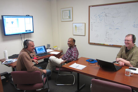
|
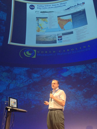
| SEDAC staff members Alex de Sherbinin, Sri Vinay, and Joe Schumacher prepare for the November 20 NASA EarthData Webinar. |
The integration of socioeconomic and remote sensing data to examine human-environment interactions was the focus of an online web-enabled seminar November 20 that featured the online data and tools available at the NASA Socioeconomic Data and Applications Center (SEDAC) operated by CIESIN. Part of NASA's EarthData Webinar series, the Webinar featured SEDAC deputy manager Alex de Sherbinin, who described SEDAC data sets and approaches to data integration, and Sri Vinay, SEDAC systems engineer, who introduced the SEDAC Web site and its web mapping tools. Vinay demonstrated how one tool, the Population Estimation Service, can be used to estimate the number of persons affected in the New York area by Superstorm Sandy. A question-and-answer segment with the online participants followed the presentations.
See: SEDAC Webinar
|
|
GIS Day Celebration at Columbia University
|
|
November 21, 2013
GIS Day is a grassroots celebration of geographic information systems (GIS) technology and its widespread application in science, industry, and education. CIESIN contributed to GIS Day activities at Columbia University for the third year in a row on November 20, co-sponsoring an information table on the Morningside campus with Consilience: The Journal of Sustainable Development. CIESIN GIS experts Tricia Chai-Onn, Linda Pistolesi, Dara Mendeloff, and Erin Doxsey-Whitfield staffed the table along with intern Jared Talkin, who is also a senior editor at Consilience. Later in the day, Esri executives Dave LaShell and Tom Sawnson gave talks sponsored by the Department of Ecology, Evolution, and Environmental Biology (E3B) and the Columbia Libraries. CIESIN coordinates Columbia's site license and support for GIS software from Esri. A number of CIESIN scientists offer Columbia courses that utilize GIS methods, data, and tools to address interdisciplinary problems in areas such as sustainable development, human-environment interactions, and public health.
See: CIESIN GIS Service Center
GIS-related Courses
|
|
Measuring Sustainability Addressed at World Economic Forum Summit
|
|
November 19, 2013
CIESIN deputy director Marc Levy participated in the World Economic Forum Summit on the Global Agenda in Dubai, United Arab Emirates, November 12–14. Levy chairs the Forum′s Global Agenda Council (GAC) on Measuring Sustainability, which released two reports at the Summit synthesizing the state of the art in sustainability metrics. He also worked with GAC members to develop a work plan for the coming year, coordinating with other GACs on cross-cutting issues and addressing the post-2015 development agenda.
See: Summary: Sustainability Metrics Report
Navigating Sustainability: Measurement, Evaluation and Action
|
|
Climate Change, Health, and Hazards Focus of Recent Visits
|
|
November 15, 2013
Experts from Viet Nam, Hawaii, and the Netherlands have recently visited CIESIN scientists in New York to discuss collaboration in the areas of climate change and health and disaster risk management. On November 6, CIESIN director Robert Chen, Geospatial Applications Division associate director Mark Becker, and senior research associate Meredith Golden met with Prof. Luu Ngoc Hoat, vice-president of Hanoi Medical University, and six colleagues who came to Columbia University to explore available data, tools, and methods for climate change and health research and applications. On November 15, CIESIN hosted Heather Bell, director of Applied Science at the Pacific Disaster Center (PDC) in Hawaii, and Richard Sliuzas of the Geo-Information Science and Earth Observation (ITC) of the University of Twente, Netherlands. Sliuzas gave a talk on flood risk management strategies in Kampala, based on a study for UN-HABITAT′s Cities and Climate Change Initiative. Bell met with CIESIN staff to explore potential areas of collaboration with the PDC on disaster data and tool development.
|
|
Cyberseminars Highlight Key Needs in International Assessment of Climate Change
|
|
November 15, 2013
The Population-Environment Research Network (PERN) hosted by CIESIN recently hosted two online cyberseminars to facilitate discussion of key challenges in the assessment of the impacts of climate change. The first cyberseminar, held October 7–14, highlighted international efforts to develop new scenarios of future socioeconomic development, which are needed not only to characterize human drivers of climate change but also to assess future exposure and vulnerability to climate impacts. The discussion focused on the new process for developing Shared Socioeconomic Pathways (SSP), initiated in support of the Intergovernmental Panel on Climate Change (IPCC). Leiwen Jiang of the National Center for Atmospheric Research (NCAR) moderated the seminar together with Susana Adamo, PERN co-coordinator and CIESIN associate research scientist. The second PERN cyberseminar was held October 28–November 5 and focused on new efforts to characterize climate-related "loss and damage" in the context of the United Nations Framework Convention on Climate Change (UNFCCC). This cyberseminar was co-organized by PERN and the United Nations University-Institute for Environment and Human Security (UNU-EHS) in Bonn, Germany. Moderated by David Wrathall of UU-EHS, participants discussed growing evidence of significant losses from extreme events, and sought to chart a research agenda in anticipation of discussions at the UNFCCC Conference of Parties 19 being held this week in Warsaw. Background papers and statements and the individual posts for both cyberseminars are available on the PERN web site.
See: PERN Cyberseminar Double Feature
Scenario Process for the IPCC Fifth Assessment Report
|
|
Workshop on Climate Change Indicators and Monitoring Held at Hunter College
|
|
November 14, 2013
CIESIN senior research associate Alex de Sherbinin served as a panelist in a workshop on monitoring and indicators of climate change, held November 13 at Hunter College of the City University of New York. The workshop was organized by the New York City Panel on Climate Change (NPCC2), which is advising the Mayor and the New York City Climate Change Adaptation Task Force on issues related to climate change and adaptation. de Sherbinin gave a presentation on urban heat island indicators, based on work in progress under a NASA grant with Battelle Memorial Institute. Other workshop topics included the New York City CoolRoofs program, the New York City urban heat stress health monitoring system, and studies of impacts of climate change on the local hydrological cycle.
|
|
Collaboration on Spatial Data Development Furthered at UN Technical Meeting
|
|
November 12, 2013
|
| CIESIN associate director Mark Becker, senior research staff assistant Erin Doxsey-Whitfield, and geographic information specialists Tricia Chai-Onn and Kytt MacManus at the United National Assembly Meeting Room, New York City, November 8. |
Staff members from the United Nations (UN) Cartographic Section and Population Division met with CIESIN associate director Mark Becker, geographic information specialists Kytt MacManus and Tricia Chai-Onn, and senior research staff assistant Erin Doxsey-Whitfield November 8 in New York City to continue collaborative efforts related to spatial data sharing and development. Becker provided an update on relevant activities such as Terra Populus and the CODATA Task Group on Global Roads Data Development. MacManus described the methods and data being used to develop version 4 of the Gridded Population of the World (GPWv4) dataset, as part of the NASA Socioeconomic Data and Applications Center (SEDAC) operated by CIESIN. Discussion included plans to establish internships at the UN for Columbia students and to collaborate on improving and using open access intercity roads data.
|
|
International Geospatial Data Community Gathers in Ethiopia
|
|
November 8, 2013
Geospatial data and technology experts from around the world met November 4–8 in Addis Ababa, Ethiopia, at the Global Geospatial Conference 2013, which focused on the theme, “Spatial Enablement in Support of Economic Development and Poverty.” CIESIN senior research associate Alex de Sherbinin gave presentations on global roads data development methodologies and climate change hotspots mapping. He also organized a meeting of the CODATA Global Roads Data Development Task Group, which is working to improve openly accessible data on intercity road networks. Organized and hosted by EIS-Africa, the Global Spatial Data Infrastructure Association (GSDI), the United Nations Economic Commission for Africa (UNECA), the Environmental Planning and Geodesign Competence Center (EiABC), and the Ethiopian Mapping Agency, the conference combined the AfricaGIS 2013 Conference with the GSDI-14 World Conference. Key sponsors included Esri, Google, Intergraph, and the Group on Earth Observations. CIESIN is a founding member of GSDI.
See: Global Geospatial Conference 2013
Conference roundup by Alex de Sherbinin for the CODATA blog
|
|
Climate Adaptation over the Last Millennium Assessed in the Mekong River Basin
|
|
November 8, 2013
Ho Chi Minh City, Vietnam, was the venue for a workshop November 5–7 focused on integrating long-term climate and archeological data from the greater Mekong River basin. CIESIN deputy director Marc Levy attended as one of the co-investigators of the research project led by Doherty associate research professor Brendan Buckley of the Lamont-Doherty Earth Observatory (LDEO). Much of the workshop centered around efforts to understand newly generated climate and hydrology time series data and new evidence concerning the evolution of Khmer settlements over the last millennium. Workshop participants reviewed data and synthesis activities undertaken to date and planned the final activities of the three-year project, which is funded by the National Science Foundation under the Dynamics of Coupled Natural and Human Systems program.
See: CNH: Paleoclimate Shocks: Environmental Variability, Human Vulnerability, and Societal Adaptation...
|
|
SEDAC Releases New Data sets and Web Site Improvements
|
|
November 7, 2013
The NASA Socioeconomic Data and Applications Center (SEDAC) operated by CIESIN has released two new data sets and added several functions to its Web site. Sea Level Rise Impacts on Ramsar Wetlands of International Importance v1 provides estimates of land area, population, and infant mortality in and near 613 wetland sites around the world that are vulnerable to increases in sea level of 1–2 meters (3–6 feet). A new Ramsar Map Client enables visualization of these sea level rise scenarios and their potential impacts. The Natural Resource Protection and Child Health Indicators, 2012 Release are national-level composite indicators developed as selection criteria for funding eligibility by the U.S. Millennium Challenge Corporation (MCC). The Natural Resource Protection Indicator (NRPI) is calculated based on the weighted average percentage of biomes under protected status. The CHI is derived from three proximity-to-target scores for access to improved sanitation, access to improved water, and child mortality. The 2012 release includes a consistent time series for the NRPI and CHI for 2006 to 2012. These indicators are successors to the Natural Resource Management Index. The SEDAC Web site now supports the export of recommended citations to bibliography or research management software such as EndNote and Zotero in two standard formats. A reference is also provided to the original scientific publication about a data set when available. These enhancements are aimed at making it easier for users to properly cite data accessed through SEDAC and to acknowledge the data authors.
See: Sea Level Rise Impacts on Ramsar Wetlands of International Importance v1
Ramsar Map Client
The Natural Resource Protection and Child Health Indicators, 2012 Release
|
|
Earth Institute Hosts Chinese Academy of Sciences Delegation
|
|
October 31, 2013
More than 20 scientists from the Chinese Academy of Sciences (CAS) visited the Earth Institute (EI) October 30 to learn about research management and priority-setting related to climate change issues. Led by Prof. Chen Xi, director general of the Xingjiang Institute of Ecology and Geography, the delegation included representatives from a range of CAS institutes addressing diverse topics such as botany, human geography, remote sensing, microelectronics, hydrology, geochemistry, and aquaculture. CIESIN director Robert Chen briefly described CIESIN′s extensive interactions with Chinese scientists over the past decade, including both bilateral exchanges and participation in international organizations and initiatives. The visit was hosted by the chair of the EI faculty, Peter Schlosser, and included other EI faculty members such as Sean Solomon, Art Lerner-Lam, Scott Barrett, Michael Gerrard, Klaus Lackner, and Stephanie Pfirman.
|
|
Geostatistical Methods and Data Presented at Bulgaria Conference
|
|
October 29, 2013
CIESIN geographic information specialist Kytt MacManus participated in the European Forum for Geostatistics (EFGS) 2013 Conference held October 23–25, hosted by the National Statistical Institute of the Republic of Bulgaria in Sofia. He joined more than 50 representatives of European statistical offices at the conference, which focused on the use of established and emerging geostatistical practices to meet real user needs. A secondary theme was the role of geostatistics in support of the planned United Nations Global System of Geo-information Management (UN-GGIM). MacManus presented a paper co-authored with Tracy Kugler of the Minnesota Population Center (MPC), “The Influence of Statistical Inputs on Global Gridded Geospatial Data Sets.” The paper discussed challenges related to ongoing work on the fourth version of the Gridded Population of the World data set (GPWv4) and the Terra Populus data system. Development of GPWv4 is supported by the NASA Socioeconomic Data and Applications Center (SEDAC) operated by CIESIN; Terra Populus is being developed by the MPC and other partners at the University of Minnesota, CIESIN, and the Inter-university Consortium for Political and Social Research (ICPSR) with support from the U.S. National Science Foundation.
See: European Forum for Geostatistics (EFGS) 2013 Conference
|
|
Research Project on High-Performance Green Infrastructure Launched
|
|
October 25, 2013
Columbia University's Fu Foundation School of Engineering and Applied Science has received a new five-year award from the National Science Foundation to develop and test a new framework for the next generation of "high-performance" Green Infrastructure (GI) systems for coastal sustainability. Using the Bronx River sewer-shed in New York City as a test bed, the project will build a platform for real-time monitoring and control of urban GI networks and address barriers to implementing GI in coastal municipalities. The research team is led by Prof. Patricia Culligan of the Department of Civil Engineering and Engineering Mechanics and includes researchers from a range of Earth Institute centers. CIESIN associate director Mark Becker is one of the project co-investigators, focused on geospatial infrastructure and analysis activities.
See: High Performance Green Infrastructure Systems to Sustain Coastal Cities (project summary)
|
|
Data Integration and Climate Hotspots Mapping Examined in Recent Presentations
|
|
October 17, 2013
CIESIN senior research associate and SEDAC deputy manager Alex de Sherbinin participated in the 2013 HyspIRI Science Workshop at the California Institute of Technology in Pasadena October 15–17. He presented a poster on the integration of remote sensing and socioeconomic data. The NASA Hyperspectral Infrared Imager (HyspIRI) mission will observe the world′s ecosystems and provide critical information on natural disasters. While in California, de Sherbinin also participated in parts of the NASA Databridge workshop, which brought together leaders in citizen science to consider how to meet societal needs using NASA earth science data. He also gave a lecture October 18 to the Climate Hazards Group and the Geography Department at the University of California, Santa Barbara, on the subject of climate hotspots mapping.
See: Integration of Remote Sensing and Socioeconomic Data (1.85 MB PDF)
|
|
International Conference Highlights Progress in Developing Global Soils Maps
|
|
October 14, 2013
Orléans, France, was the site of the first GlobalSoilMap Conference held October 7–9, with approximately 100 attendees. Sponsored by the Institute National de la Recherche Agronomique (INRA), the International Union of Soil Science (IUSS), ISRIC - World Soil Information, and other leading research and soil science agencies and organizations, the conference focused on recent progress in developing new digital data resources on soils to meet the pressing needs of farmers, agronomists, resource managers, and other users for improved soil information. CIESIN senior staff associate Sonya Ahamed attended the conference as a representative of the Africa Soil Information Service (AfSIS), a collaboration between the Columbia Global Center|East Africa, the Earth Institute, and African scientists and institutions, supported by the Bill and Melinda Gates Foundation. She also represented the Earth Institute at a meeting of the Global Soil Consortium held the following day on the INRA campus in Orleans.
See: GlobalSoilMap Conference 2013
|
|
Special Issues of Climatic Change Feature Work by CIESIN Scientists
|
|
October 11, 2013
A special issue of the journal Climatic Change,"Climate and Security: Evidence, Emerging Risks, and a New Agenda" features a paper by CIESIN senior research associate Alex de Sherbinin, “Climate Change Hotspots Mapping: What Have We Learned?” The article focuses on “hotspots” of climate change–regions especially vulnerable to current or future climate impacts where human security may be at risk. CIESIN deputy director Marc Levy is second author of another paper, “Enhancing the Relevance of Shared Socioeconomic Pathways for Climate Change Impacts, Adaptation and Vulnerability Research,” by Bas J. van Ruijven, Levy, and 22 other colleagues. This paper appears in another Climatic Change special issue, "A Framework for the Development of New Socio-economic Scenarios for Climate Change Research.”
See: “Climate Change Hotspots Mapping: What Have We Learned?”
“Enhancing the Relevance of Shared Socioeconomic Pathways…”
|
|
CIESIN Staff Fly South for Data
|
|
October 4, 2013
Three cities in the southeast United States were the destination of CIESIN staff members participating in data-related meetings. In Columbia, South Carolina, associate research scientist Susana Adamo attended the second meeting of the Disaster Loss Data Working Group of the Integrated Research on Disaster Risk (IRDR) program, which was hosted September 29–October 1 at the University of South Carolina. IRDR is an international research program aimed at the challenges of natural disasters, mitigating their impacts and improving related policy-making mechanisms. It is co-sponsored by the International Council for Science (ICSU), the International Social Science Council (ISSC), and the United Nations International Strategy for Disaster Reduction (UNISDR). On October 2, geospatial information specialist Kytt MacManus participated in a workshop on urbanization, population, and sustainability in Chattanooga, Tennessee, held in conjunction with the Society of Environmental Journalists Conference. He demonstrated the application of CIESIN data and services to an audience of approximately 40 journalists. CIESIN director Robert Chen attended the fall meeting of the Board of Directors of the National Ecological Observatory Network (NEON), held in Gainesville, Florida, October 2–4. NEON is a continental-scale ecological observation system for examining critical ecological issues funded by the National Science Foundation.
|
|
New Faces at CIESIN
|
|
October 3, 2013
Several visiting scholars and new research assistants have joined CIESIN recently. Here for the fall semester is Lina Eklund, a graduate student from the Center for Middle Eastern Studies (CMES) at the Department of Earth and Ecosystem Sciences, Lund University, Sweden. Eklund is conducting independent research using remote sensing and other types of data such as surveys and secondary data to investigate urbanization in Kurdistan and its effects on land use, rural development, and urban-rural migration. Visiting CIESIN for a year and a half is Yuanyuan Yang, a doctoral student in land use management from Jilin University in China. Her research focuses on changes in farmland ecosystems in Northern China in response to climate warming over the past century. Yang also has a BS in land resource management from Jilin. Xiaoteng Cen is a doctoral student in land use & land use policy at Zhejiang University, China, who will be at CIESIN for one year. He is researching land use changes driven by land use policy in the Zhejiang coastal region. Olena Borkovska and John Squires have joined the CIESIN team as research assistants for version 4 of the Gridded Population of the World. Borkovska has a BA in environmental policy and management from the Geography Department of Hunter College, City University of New York. Squires, who is also working on the project Developing Global Building Exposure for Disaster Forecasting, Mitigation, and Response, recently received his BA in sustainable development from Columbia. Jane Mills is working on the Hudson River Flood Hazard Decision Support System project, and creating maps of Haiti's governmental offices as part of CIESIN’s activities in Haiti. Mills has a BA in applied mathematics from Barnard and a minor in environmental science.
|
|
CIESIN Launches Collaborations with Zhejiang University
|
|
September 28, 2013
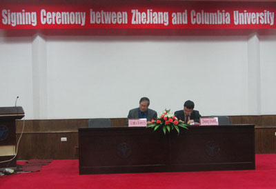
|
| CIESIN director Robert Chen and Department of Land Management chair Yuzhe Wu sign a letter of agreement at Zhejiang University, September 26. |
Together with the Lamont-Doherty Earth Observatory (LDEO), CIESIN has signed a letter of agreement with the Department of Earth Sciences and Ocean College of Zhejiang University, a leading research university located in Zhejiang Province, China. CIESIN also signed a second letter of agreement with the Department of Land Management at Zhejiang, focused on collaboration related to land use/land cover change, vulnerability assessment, and performance monitoring. These agreements are expected to facilitate joint research, student and visitor exchanges, and other collaborative activities. The signing of the agreements took place during a joint Zhejiang-Columbia University workshop, “Earth Sciences and Sustainable Development,” held at Zhejiang University September 26–27. CIESIN director Robert Chen, associate research scientist Susana Adamo, and senior staff associate Xiaoshi Xing participated actively in the workshop, giving presentations on a range of CIESIN research and data activities. Other workshop participants included Earth Institute faculty member Joel Cohen, LDEO deputy director Art Lerner-Lam, and LDEO scientists Benjamin Bostick, James Gaherty, Donna Shillington, Christopher Small, and Felix Waldhauser. Prof. Cohen also gave a keynote lecture in a University-wide “Oriental Forum” September 27, with additional commentary provided by Lerner-Lam and Chen.
|
|
Global Change Scientists Gather in Beijing for Scientific Symposium
|
|
September 26, 2013
Eleven international experts joined nearly 500 Chinese scientists at the 2013 Beijing Symposium on Global Change at the Beijing Conference Center September 23–25 to present and discuss research on global change and its implications for sustainable development. The Symposium included presentations by more than 40 research teams supported by the Ministry of Science and Technology (MOST) of China, covering a range of natural, social, and health science topics. Plenary talks were given by Gordon McBean, president-elect of the International Council for Science (ICSU), Sir Brian Hoskins of Imperial College, London; Stephen Briggs of the European Space Agency, and other experts from Australia, Germany, Malaysia, and the United States. CIESIN director Robert Chen presented on the urgent need for reliable data and indicators on climate change impacts and adaptation. The Symposium was sponsored by MOST, the Chinese Academy of Sciences, the China Association for Science and Technology, the National Natural Science Foundation of China, and several other institutes and academic organizations.
See: Beijing Symposium on Global Change - 2013
|
|
Modeling and Predicting the Global Distribution of Population
|
|
September 24, 2013
The state-of-the-art in projecting global patterns of population distribution was the focus of a September 20 workshop organized by the Urbanization and Global Environmental Change project and the Institute for Sustainable Cities (CISC) at the City University of New York (CUNY). The meeting identified methods and approaches for generating spatial population projections with 50- to 100-year time horizons for use in climate impact assessment and ecological research. CIESIN associate research scientist Susana Adamo and senior research associate Alex de Sherbinin participated in a panel moderated by former CIESIN scientist Deborah Balk, now with of the Institute for Demographic Research at the City University of New York. They presented CIESIN′s work on gridding population data, spatial population projections, estimation of net migration, and urban growth patterns.
|
|
Roundtable Addresses Role of Practice and Practitioners at the Earth Institute
|
|
September 23, 2013
More than 40 faculty, staff, and students met September 20 at the Columbia Law School to consider how the Earth Institute (EI) can improve its capacity to support real-world sustainable development. Organized by the Practice Committee of the Earth Institute Faculty, the “Practice Makes Perfect” Roundtable included three panels that highlighted lessons learned from EI practice-oriented projects, the individual and collective responsibilities of those engaged in practice, and concerns about professional development in a university environment. CIESIN deputy director Marc Levy and senior staff associate Sonya Ahmed contributed their perspectives on working on innovative sustainable development initiatives in Haiti and Africa. The Roundtable was organized and led by Ed Lloyd, Professor of Practice at the Law School and outgoing chair of the Practice Committee, and by Robert Chen, CIESIN director and member of the Practice Committee.
|
|
Research Data Alliance Holds Second Plenary in Washington, DC
|
|
September 19, 2013
Building global partnerships to improve sharing and management of scientific data was the focus of the second plenary meeting of the Research Data Alliance (RDA), a new international initiative led by scientists and science agencies from the U.S., Europe, and Australia. Held at the National Academy of Sciences in Washington, DC, September 16–18, the meeting drew more than 350 experts from around the world to work on specific projects and develop new collaborations across a range of scientific disciplines. CIESIN director Robert Chen co-chaired a session on the legal interoperability of scientific data together with Paul Uhlir of the National Research Council and Enrique Alonso García, Counselor of State, Spain. CIESIN senior digital archivist Robert Downs and Chen also presented a poster, “Independent Evaluation of a Scientific Data Center for Compliance with the ISO 16363 Requirements for Audit and Certification of Trustworthy Digital Repositories.″
See: Independent Evaluation of a Scientific Data Center for Compliance with the ISO 16363 Requirements...(245KB PDF)
Poster objectives—description
|
|
Scientific Data Repositories Highlight Need for Sustainable Funding
|
|
September 18, 2013
Representatives of 25 archives of scientific data from around the U.S. have issued a call for change on how to sustain “domain″ data repositories—data archives with close ties to their scientific communities. Coordinated by the Inter-university Consortium for Political and Social Research (ICPSR), the call addresses the growing mismatch between short-term funding of data archives and the increasing focus on open access data resources, exemplified by the February 2013 memorandum from the U.S. Office of Science and Technology Policy (OSTP) requiring public access to federally funded data. To sustain such open resources in the long term, the domain repositories need to be supported as key components of the U.S. research infrastructure. CIESIN director Robert Chen is one of the signatories of the call, which stems from a meeting held at ICPSR in Ann Arbor, Michigan, in June 2013, supported by the Alfred P. Sloan Foundation.
See: Sustaining Domain Repositories for Digital Data: A Call for Change...
|
|
Indicators Workshops Held in Sweden
|
|
September 13, 2013
|
| The water indicators workshop team in the room used for the Nobel Laureate selection committee at the Royal Swedish Academy of Sciences, Stockholm, September 12. |
The development of useful and credible indicators of socioeconomic and environmental change is a pressing challenge for the international community. Senior research associate Alex de Sherbinin represented CIESIN at a preliminary results review workshop for the Transboundary Waters Assessment Programme (TWAP) River Basins Component, held September 9–11 in Waxholm, Sweden. CIESIN is part of an international team led by the UNEP-DHI Center for Water and Environment that is working to develop quantitative indicators on a variety of dimensions, including water quantity, water quality, ecosystems, governance, and socioeconomic trends, for use by key stakeholders. In partnership with colleagues at the Yale Center for Environmental Law and Policy (YCELP), de Sherbinin also helped organize a second workshop September 11–12 in Stockholm, focused on the next generation of water quantity and quality indicators for the 2014 Environmental Performance Index (EPI). Participants included representatives of UNEP-DHI, Kassel University in Germany, and the International Geosphere-Biosphere Programme (IGBP). The EPI ranks countries on their environmental performance and progress on two broad policy objectives, environmental health and ecosystem vitality. Released every two years, the EPI has had significant impact on environmental policy and decision making in a range of governmental and nongovermental settings.
See: Transboundary Waters Assessment Programme River Basins Component
|
|
Agriculture, Environment, and Livelihoods the Focus of Columbia Seminar
|
|
September 11, 2013
A distinguished group of experts from around the world gathered in the rotunda of Columbia's Low Library for an all-day seminar, “The Nexus of Agriculture, Environment and Livelihoods,” marking the inauguration of the new Agriculture and Food Security Center (AFSC) within the Earth Institute. After a welcome by Columbia University president Lee Bollinger and Earth Institute executive director Steve Cohen, keynote speaker Akinwumi Adesina, Nigeria's minister of agriculture and rural development, gave an inspiring talk about the rapid progress transforming agriculture in Nigeria over the past two years, building on innovative approaches to sustainable agriculture and food security. AFSC director Pedro Sanchez and colleagues outlined the AFSC′s strategy for the future, which includes a strong emphasis on data and metrics for agricultural planning and decision making. CIESIN deputy director Marc Levy chaired a panel on integrating agricultural data, and senior staff associate Sonya Ahmed helped demonstrate the data and information resources available from the Africa Soil Information Service (AfSIS). The seminar also included remarks by Columbia′s provost, John Coatsworth; Earth Institute director Jeffrey Sachs; and Lamont-Doherty Earth Observatory director Sean Solomon.
See: Inaugural Seminar: Agriculture and Food Security Center
|
|
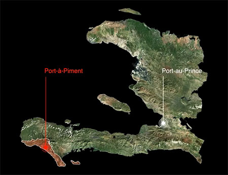
New Portal Provides Dynamic Platform for Haiti Spatial and Environmental Data
|
|
September 6, 2013
|
| 3-D Visualization of Port-à-Piment Watershed, Republic of Haiti. |
After four years of field research and analytic support provided to the Republic of Haiti and multiple partners there, CIESIN is pleased to launch the Haiti GeoPortal. The Haiti Geoportal is a platform for spatial and environmental data and resources from ongoing research in Haiti as part of the broader Haiti Research and Policy Program at the Earth Institute (EI) at Columbia University. Featuring an online interactive map component, the Haiti Geoportal is designed to let communities and partners download maps that provide benchmarks for core integrated development indicators, household socio-economic variables, and environmental features. The data covers geographic extents that range from national scale to local communities in Haiti. The Web site contains a data library and a searchable bibliography of materials from the EI and non-EI, including scientific reports and literature and data visualization videos produced to help articulate multi-hazard risk in the watershed of Port-à-Piment. The Haiti Geo-Portal has been supported by numerous partner organizations and funders, including the support of the W.K. Kellogg Foundation. The data has been collected from other organizations and generated from field studies conducted by EI teams through the support of the W.K. Kellogg Foundation, the Haiti Reconstruction Fund via the United Nations Environment Programme (UNEP), the Catholic Relief Services (CRS), the Green Family Foundation, and the Earth Institute.
See: Haiti Geo-Portal
|
|
Leader in Environmental Law Community Passes Away
|
|
August 30, 2013
CIESIN notes with sadness the passing of Dr. Françoise Burhenne-Guilmin, head of the IUCN Environmental Law Center (ELC) in Bonn, Germany. Dr. Burhenne-Guilmin initiated the Environmental Law Information System (ELIS), which over the years evolved into the far more sophisticated online information system ECOLEX, the Gateway to Environmental Law. In 2000, CIESIN utilized ELIS in the development of the Environmental Treaties and Resource Indicators (ENTRI) Web application. Dr. Burhenne-Guilmin was a dedicated and tireless legal professional who will be missed by the environmental community.
See: Tribute to Françoise Burhenne-Guilmin
|
|
NASA Invites Data Center Users to Evaluate Services and Support
|
|
August 29, 2013
Every year NASA conducts a survey of users of the Earth Observing System Data and Information System (EOSDIS) to assess their satisfaction with the data, tools, and support provided by EOSDIS data centers. SEDAC, the Socioeconomic Data and Applications Center operated by CIESIN, is one of the centers evaluated by the Web-based survey. Registered SEDAC users should receive an e-mail invitation from CFI Group on behalf of NASA to provide feedback on the quality and utility of SEDAC products and services. Please participate! Your feedback affects our future performance and helps us to identify and address user needs. Completing the anonymous questionnaire takes approximately 20 minutes. Optional comment fields are provided. If you are not currently a registered user, but would like to complete the survey, please contact SEDAC User Services. We thank those who have participated in previous surveys and encourage you to provide feedback again this year! Your comments are useful as we continue to expand and improve SEDAC's data, services and web site.
|
|
Earth Institute Researchers Explore Factors Related to Forced Migration in Haiti
|
|
August 16, 2013
The week of August 5, CIESIN web specialist Melika Edquist traveled with Sabine Marx, managing director of the Center for Research on Environmental Decisions, to the South Department of Haiti, where they conducted field research on linkages between environmental risk perceptions and forced migration. Their project is examining migration as a coping strategy in response to problems of poverty, environmental insecurity, and lack of adequate health care and education. The project is part of a collaboration with the Association of Volunteers in International Service (AVSI), an Italian non-governmental organization. The trip also included a day of training on qualitative research methods with students and faculty of the Université de Notre Dame en Haiti.
|
|
EPA Holds Community Involvement Training in Boston
|
|
August 5, 2013
Meredith Golden, CIESIN senior research associate, participated in the “2013 US EPA Community Involvement Training Conference″ and preconference “Superfund Monday,” organized by the U.S. Environmental Protection Agency (EPA) in Boston July 29–August 1. Golden provided a live technology demonstration and poster presentation on the NPL Superfund Footprint: Site, Population, and Environmental Characteristics Mapping Tool developed by CIESIN as part of the Columbia University NIEHS Superfund Research Program Research Translation Core. The Mapper was created for academic researchers, government regulators, and community stakeholders to help visualize critical data related to the area and inhabitants near Superfund sites in order to better assess the vulnerability of affected populations and to prioritize cleanups. Newly confirmed EPA Administrator Gina McCarthy gave the plenary presentation on the need for active community involvement in environmental policymaking and implementation. More than 400 EPA staff, agency stakeholders, and collaborative partners attended multiple workshops designed to enhance capacity to achieve these community involvement goals, with topics on best practices, innovative tools and technologies, and new software.
See: NPL Superfund Footprint Mapping Tool
2013 US EPA Community Involvement Training Conference
|
|
Teachers Invited to Learn about Climate and Health Mapping in Online Workshop
|
|
August 2, 2013
Middle-and high-school teachers may register now for an online workshop, noon–3pm Tuesday, August 13 or Thursday, August 15, to learn to use the CHANGE Viewer Mapping Tool. Developed by the Institute for the Application of Geospatial Technology (IAGT) and CIESIN with funding from NASA Innovations for Climate Education, the CHANGE Viewer visualizes climate and human health data to engage students in learning about the impacts of climate change on human health around the world. The online workshop will include an introduction, exercises to build competency, and guidance on developing a customized curriculum built around student use of the tool. Each session is limited to 40 teachers. To reserve a spot, please register by Wednesday, August 9. For more information, contact Mark Becker, CIESIN's associate director for geospatial applications, at mbecker@ciesin.columbia.edu, or visit the CHANGE Viewer Web site.
See: Register
Change Viewer Mapping Tool
|
|
NASA Extends Socioeconomic Data Center Activities at CIESIN
|
|
August 1, 2013
The integration of socioeconomic and remote sensing data to support both scientific research and societal applications continues to be an important element of the NASA Earth Observing System Data and Information System (EOSDIS). The NASA Goddard Space Flight Center (GSFC) has awarded CIESIN a follow-on contract effective August 1 to operate the NASA Socioeconomic Data and Applications Center (SEDAC) for another year, with the option of up to four additional years. CIESIN director Robert Chen will continue to serve as the SEDAC manager and principal investigator, along with deputy manager Alex de Sherbinin and system engineer Sri Vinay. SEDAC provides a range of socioeconomic and integrated data products and services to tens of thousands of users each month, with particular emphasis on the needs of geospatial data users, policy- and decision-makers, and those involved in research on the human dimensions of global change. SEDAC works closely with other EOSDIS data centers and with external partners and networks to facilitate access to and integration of data from a range of scientific disciplines to address pressing scientific and societal problems. Users may contact SEDAC's User Services office for information and assistance.
See: NASA Socioeconomic Data and Applications Center (SEDAC)
|
|
CIESIN Scientists Accept New Roles in Ecology and Global Change Research Institutions
|
|
July 30, 2013
CIESIN associate research scientist Susana Adamo and director Robert Chen have been appointed to key management bodies of the Inter-American Institute for Global Change Research (IAI) and the National Ecological Observatory Network (NEON), respectively. Adamo has begun a three-year term on the IAI Scientific Advisory Committee, which makes recommendations to the IAI's Conference of the Parties regarding the institute′s scientific agenda and its annual program and long-term plans, and also assesses the IAI′s research results. The committee is chaired by Frank E. Muller Karger of the University of South Florida and includes ten scientists representing a range of disciplines involved in global change research. Established in 1992, the IAI is an intergovernmental organization supported by 19 countries in the Americas that is working to increase the understanding of global change phenomena and their socio-economic implications. Chen has been appointed for three years as an at-large member of the NEON Board of Directors, which is chaired by James P. Collins of Arizona State University. NEON, Inc. is a registered 501(c)(3) nonprofit organization solely funded by the U.S. National Science Foundation to enable understanding and forecasting of the impacts of climate change, land use change and invasive species on continental-scale ecology. NEON is currently in its construction phase, with the aim of establishing an operational observatory network in the 2017 time frame.
See: IAI Scientific Advisory Committee
NEON Board of Directors
|
|
Biomass Burning and Climate Change Impacts Discussed in Recent Visits
|
|
July 24, 2013
CIESIN recently hosted visits by Prof. Emilio Chuvieco from the Department of Geography and Geology, Universidad de Alcalá, Spain and Prof. Francisco Meza of the Pontificia Universidad Católica de Chile. Chieveco gave a “brownbag” lunch presentation July 23 on the subject of a global monitoring program for biomass burning. Meza, who is director of the Centro de Cambio Global at his university and co-director of AQUASEC, the Center of Excellence for Water Security of the Inter-American Institute for Global Change Research (IAI), met with CIESIN director Robert Chen and others July 17 to discuss areas of collaboration. Meza and Chen are both members of the Task Group on Data and Scenario Support for Impacts and Climate Analysis (TGICA) of the Intergovernmental Panel on Climate Change (IPCC).
|
|
Climate and Human Security to Be Addressed in Forthcoming IPCC Assessment
|
|
July 23, 2013
CIESIN deputy director Marc Levy attended the final Lead Authors' Meeting of the Intergovernmental Panel on Climate Change (IPCC) Working Group II held in Bled, Slovenia July 14–18. Working Group II, which focuses on impacts, adaptation and vulnerability, is devoting a chapter to the topic of human security, including such issues as conflict, migration, employment, inequality, and indigenous peoples. As one of the chapter's lead authors, Levy spent the week with his co-authors evaluating responses to peer-review comments, coordinating with other chapter teams, and discussing final revisions to the chapter. The IPCC Fifth Assessment is expected to be released in spring 2014.
See: IPCC Working Group II
|
|
Conference in Germany Focuses on Climate-Induced Migration
|
|
July 22, 2013
Susana Adamo, CIESIN associate research scientist, was a keynote speaker at the “Hamburg Conference: Actions for Climate-Induced Migration,” held July 16–18 in Hamburg, Germany and organized by the Climate Service Center and the Klima Campus at the University of Hamburg. Her presentation, “Migration, Cities, and Climate Change in Latin America,” focused on the complex relationship between the impacts of climate change events, the dual role of cities as places of origin and destination of migration flows (including climate-induced migration), and the vulnerability of migrants. She also participated in a July 15-16 workshop on knowledge creation and capacity building for actions in climate-induced migration.
See: “Hamburg Conference: Actions for Climate-Induced Migration”
“Migration, Cities, and Climate Change in Latin America” (1.81 MB PDF)
“Knowledge Creation and Capacity Building...” (205 KB PDF)
|
|
Targets for Reducing the Risks of Disasters Considered at UN Technical Meeting
|
|
July 19, 2013
The human and economic toll of large-scale disasters is widely recognized, but in many parts of the world efforts to reduce disaster risks are limited and not well integrated into economic and social development. To help focus attention on the benefits of disaster risk reduction for sustainable development, a technical meeting “Targets and Indicators for Addressing Disaster Risk Management in the Post-2015 Development Agenda” was held in New York July 18–19. CIESIN senior staff associate Alex de Sherbinin gave a presentation on the use of indicators related to environmental performance and sustainability in policy and decision making. Director Robert Chen moderated a panel session on building the evidence base for key indicators and targets identified in the meeting breakout groups. Alliance Program intern Fannie Delavelle also participated in the meeting as a rapporteur. The technical meeting was organized by the United Nations Development Programme, the United Nations Children's Fund, the United Nations Office for Disaster Risk Reduction, and the Global Facility for Disaster Reduction and Recovery. It aims to provide technical inputs on potential disaster-related targets and indicators to be incorporated into a new set of sustainable development goals that would supersede the current Millennium Development Goals in 2015.
|
|
Chapel Hill Meetings Highlight Education and User Needs for Earth Observation Data
|
|
July 12, 2013
|
| CIESIN senior digital archivist Robert Downs gives a presentation July 10 at the North Carolina Museum of Natural Sciences, on the SEDAC Population Estimation Service and data resources. 2013 ESIP Summer Meeting, Chapel Hill, North Carolina. |
Chapel Hill, North Carolina was the venue for back-to-back meetings addressing different aspects of the use of remote sensing and other environmental data in research, applications, and teaching. CIESIN senior digital archivist Robert Downs participated in the 2013 DataONE User Group Meeting July 7–8, where he presented a poster authored with CIESIN director Robert Chen, “Enabling Discovery and Use of Education and Professional Development Resources to Improve Geospatial Data Management and Preservation Practices.” As part of the meeting, he led a roundtable on data management planning. Downs then joined the 2013 Summer Meeting of the Federation of Earth Science Information Partners (ESIP) July 9–12, where, in a special workshop for teachers, he gave a presentation on classroom use of the NASA Socioeconomic Data and Information Applications Center (SEDAC) Population Estimation Service. He also presented a second poster authored with Chen, “Measuring the Multidisciplinary Impact of Scientific Data Disseminated by the NASA SEDAC.” On July 10, Downs was one of the ESIP meeting attendees who shared their work at the North Carolina Museum of Natural Sciences, and on July 11 he gave another presentation on the topic of using SEDAC data to meet next-generation science education standards. The ESIP Federation meeting was hosted by the University of North Carolina at Chapel Hill and the Renaissance Computing Initiative (RENCI). DataOne, the Data Observation Network for Earth, is one of the DataNet projects supported by the National Science Foundation; CIESIN is also a partner in a DataNet project led by the University of Minnesota, Terra Populus.
See: DataONE User Group Meeting
“Enabling Discovery and Use of Education and Professional Development Resources..." (544 KB)
2013 ESIP Summer Meeting
"Measuring the Multidisciplinary Impact of Scientific Data…”
|
|
Geospatial Data Applications Featured at Esri International User Conference
|
|
July 12, 2013
CIESIN geographic information specialist Dara Mendeloff joined more than 15,000 other geospatial data and technology experts at the 2013 Esri International User Conference in San Diego July 8-12. As part of the competition for “Best Cartographic Design: Map Series or Atlas—In‐House,” she presented a poster in the Map Gallery opening reception Monday, July 8. The poster describes case studies of the relationships between climate stressors and social impacts in vulnerable communities in Bangladesh, Bhutan, The Gambia, Kenya, and Micronesia. The case studies were drawn from a research project by the United Nations University Institute for Environment and Human Security (UNU-EHS), to which CIESIN contributed (Where the Rain Falls: Climate Change, Food and Livelihood Security, and Migration Global Policy Report).
See: "From the Frontlines of Climate Change..." (6.32 MB PDF)
|
|
Managing Natural Disaster Risk in East Asia Subject of Beijing Seminar
|
|
June 29, 2013
At the invitation of the Chinese Ministries of Civil Affairs, Mark Becker, CIESIN associate director for geospatial applications, participated in the Seminar on Risk Management of Major Natural Disasters held June 24–28 in Beijing under the auspices of the East Asia Summit (EAS). Becker presented CIESIN's work in the area of population and infrastructure exposure to natural hazards such as earthquakes, focusing in particular on a project led by the University of Pavia to develop a global database on exposure as part of the Global Earthquake Model (GEM) initiative. GEM is an international partnership to improve assessment and decision making regarding earthquake risk through the development of an open earthquake risk assesment framework. The seminar drew about 50 participants from twelve of the eighteen EAS member countries and included a visit to China's National Disaster Reduction Center outside of Beijing.
|
|
Virtual Lectures on Scenario Development/Sustainability Science Data Needs
|
|
June 28, 2013
CIESIN deputy director Marc Levy and director Robert Chen gave virtual lectures June 27 to two different groups of scientists and scholars. Levy spoke to a distributed international network of health researchers involved in the Institute of Medicine (IOM) Innovation Collaborative on Global Environmental Health and Sustainable Development. He described the ongoing development of new socioeconomic and climate scenarios needed to assess the long-term implications of climate change, through a process coordinated with the Intergovernmental Panel on Climate Change (IPCC) Fifth Assessment Report (AR5). Chen gave an invited talk to more than 100 faculty, staff, students, and other guests at the Forum on the Future of Scientific Publishing: Open Access to Manuscripts & Big Data held at Stanford University in Palo Alto, California. His presentation addressed the need for sustainable, open access data in the rapidly expanding field of sustainability science.
See: Global Environmental Health Webinar
Scenario Process for AR5
Stanford University Forum on the Future of Scientific Publishing
|
|
Data Management, Analysis, and Visualization Addressed in U.S. Meetings
|
|
June 28, 2013
CIESIN staff members recently participated in four meetings around the U.S. on different aspects of data management, analysis, and visualization. On June 16-20, senior staff associate Sonya Ahmed attended the 2013 National Cooperative Soil Survey (NCSS) National Conference in Annapolis, Maryland. She gave an overview of efforts to develop digital soils maps for Africa as part of the Africa Soil Information Service (AfSIS), a major initiative funded by the Bill and Melinda Gates Foundation. On June 24-25 in Hampton, Virginia, senior research associate Alex de Sherbinin and senior media designer Al Pinto participated in a NASA technical meeting on data visualization and browse imagery for data from the Earth Observing Data and Information System (EOSDIS), including data from the Socioeconomic Data and Applications Center (SEDAC) operated by CIESIN. At the same time, CIESIN director Robert Chen traveled to Ann Arbor, Michigan to attend a workshop on "Sustaining Domain Repositories for Digital Data," organized by the Inter-university Consortium for Political and Social Research (ICPSR) at the University of Michigan and sponsored by the Alfred P. Sloan Foundation. He participated in a panel discussion on data infrastructure at national and international levels chaired by Sayeed Choudhury of Johns Hopkins University. Further west, geographic information specialist Kytt MacManus attended the twelfth annual Scientific Computing with Python conference (SciPy 2013) June 24-28 in Austin, Texas. He gave a presentation on recent research activities at CIESIN to develop a uniform and efficient data structure for summarizing global geographic information.
See: Developing Digital Soils Maps of Africa (pdf file)
Scientific Computing with Python
|
|
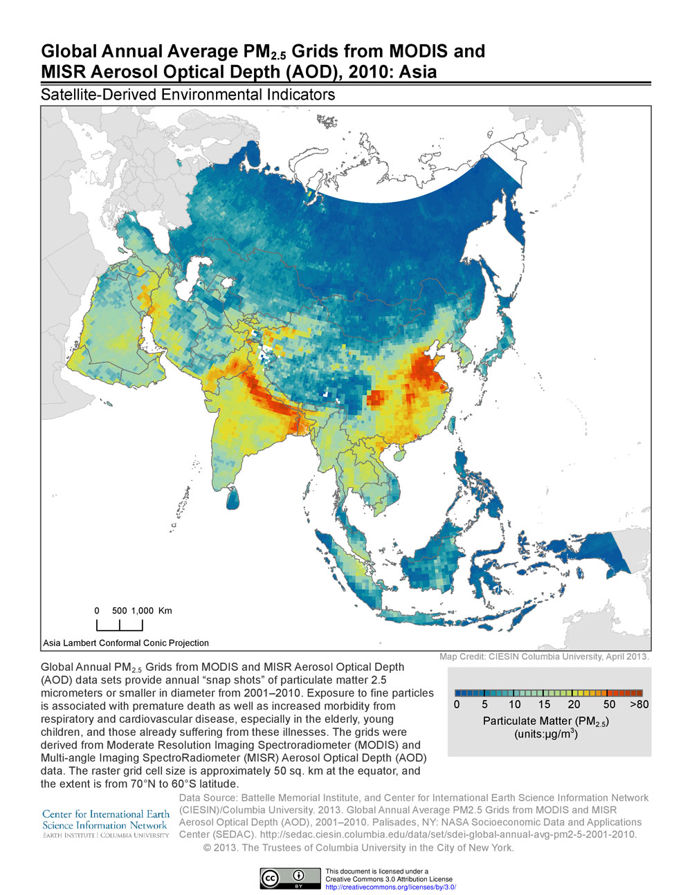
Satellites Help Monitor Air Pollution Around the World
|
|
June 26, 2013
Satellite observations are proving to be a valuable tool in assessing air pollution, specifically one of the worst pollutants, PM2.5 (microscopic particles smaller than 2.5 microns in diameter). Ground-based monitoring of this type of pollutant, which can lodge deep in lungs and may lead to respiratory and cardiovascular diseases, is expensive. Many countries lack the technical and financial resources to set up their own monitoring systems. Satellite monitoring, though less accurate than ground-based measurements, has the advantage of providing wall-to-wall coverage at relatively low cost. Building on a model developed by researchers at Dalhousie University that estimates ground-based concentrations of PM2.5 from data on aerosol optical depth (AOD), a team from the Battelle Memorial Institute and CIESIN developed annual estimates of PM2.5 concentrations over a 10-year period on a global latitude-longitude grid. The AOD data were obtained from two different NASA instruments, the Moderate Resolution Imaging Spectroradiometer (MODIS) and the Multi-angle Imaging SpectroRadiometer (MISR). The gridded data, developed by the NASA-funded project, "Using Satellite Data to Develop Environmental Indicators: An Application of NASA Data Products to Support High Level Decisions for National and International Environmental Protection," are the basis for environmental indicators designed to support health and environmental research and decision making. For example, they have been used in developing the particulate matter indicator of the 2012 Environmental Performance Index (EPI). Exposure to high levels of PM2.5 is associated with premature death as well as increased morbidity from respiratory and cardiovascular disease, especially among the elderly, young children, and those already suffering from these illnesses. The World Health Organization guideline for PM2.5 average annual exposure is less than or equal to 10.0 micrograms per cubic meter, whereas the U.S. Environmental Protection Agency (EPA) primary standard is less than or equal to 12.0 micrograms per cubic meter.
See: Satellite-Derived Environmental Indicators
|
|
Innovative Strategies for Global Agriculture and Food Systems Examined
|
|
June 14, 2013
|
| Participants gather on the final day of the meeting, “Navigating New Risk Landscapes & Opportunities in Global Food Systems,” held in Tällberg, Sweden, June 11–13. |
The sharing and integration of data, information, and knowledge related to global agriculture and food systems was one of the major themes of a meeting of about 40 global leaders in Tällberg, Sweden, June 11–13. The meeting, “Navigating New Risk Landscapes & Opportunities in Global Food Systems,” was organized by the Knowledge Systems for Sustainability Collaborative as an “invited initiative” immediately preceding the June 13-15 Tällberg Forum. Molly Jahn, former Dean of the University of Wisconsin's College of Agricultural and Life Sciences and a member of the Commission for Sustainable Agriculture and Climate Change, led the initiative, with co-organizers Aled Jones of Anglia Ruskin University and CIESIN deputy director Marc Levy. The Tällberg Forum is an annual gathering of more than 300 leaders and thinkers sponsored by the Tällberg Foundation, an international non-profit organization established in 1981 as a platform for a free and open exchange of ideas and experiences.
|
|
Digital Stewardship Focus of New York City Meeting
|
|
June 14, 2013
The National Digital Stewardship Alliance (NDSA), an initiative of the National Digital Information Infrastructure and Preservation Program (NDIIPP) led by the Library of Congress, held a regional meeting in New York City June 14 hosted by the Metropolitan New York Library Council. CIESIN senior digital archivist, Robert Downs, gave a presentation authored with director Robert Chen on the development and management of the Geospatial Data Preservation Resource Center, an element of the NDIIPP focused on stewardship of spatial data. The regional meeting brought together NDSA members and NDIIPP partners from New York and Connecticut to discuss a range of digital preservation issues in the arts, sciences, and humanities. CIESIN is both a member of the NDSA and an NDIIPP partner.
See: NDSA Regional Meeting
|
|
Art-Science Collaboration Continues During Informal Visit
|
|
June 5, 2013
Lars Jan, founding artistic director of Early Morning Opera, visited CIESIN in Palisades, New York June 4 to continue collaborative discussions started at the “Art and Science Dating Game,” which took place in March at the Metropolitan Museum of Art in New York City. Jan met again with CIESIN director Robert Chen as well as with other CIESIN and Earth Institute staff members to examine how various types of scientific data could be woven into Jan's new performance project, Holoscenes. Holoscenes is an ambitious effort to use water as a medium of expression about human-climate interactions on multiple time and space scales. Jan gave an informal brown bag talk about his work to CIESIN and other staff at the Lamont campus. He was accompanied by Rasu Jilani, director of community programs at Mapp International Productions, which is producing Holoscenes. This art-science collaboration was facilitated by PositiveFeedback, an initiative of the Earth Institute, the Center for Creative Research at New York University, and the Institute for Sustainable Cities of the City University of New York.
See: Holoscenes
|
|
Marc Levy to Chair WEF Global Agenda Council on Measuring Sustainability
|
|
June 4, 2013
CIESIN deputy director Marc Levy has accepted an appointment as chair of the World Economic Forum (WEF) Global Agenda Council on Measuring Sustainability for the 2013-2014 term, beginning next month. He initially joined the Council last year. The Council is working to promote a new framework for measuring sustainability based on a systemic approach to the multiple dimensions of risk and opportunity, and to demonstrate the value of this approach through an open data platform focused on agriculture and food security. The Council includes more than 15 prominent experts from government, industry, nongovernmental organizations, and other initiatives around the world concerned with sustainability and its measurement. Within the network of WEF Global Agenda Councils, Levy is also contributing to the Task Force on Sustainable Development Goals.
See: World Economic Forum (WEF) Global Agenda Council on Measuring Sustainability
|
|
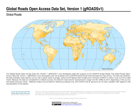
New Digital Roads Data Set Characterizes Intercity Road Networks Around the World
|
|
May 24, 2013
CIESIN has released a digital global data set on intercity roads, the Global Roads Open Access Data Set, Version 1 (gROADSv1). Developed under the auspices of the Global Roads Data Development Task Group of the Committee on Data for Science and Technology (CODATA) of the International Council for Science, gROADSv1 combines the best available open access data on roads between human settlements into a global roads coverage consistent with the United Nations Spatial Data Infrastructure Transport (UNSDI-T) version 2 data model. This first version of the gROADS data set is part of a continuing effort to address the need among professionals in the humanitarian response, development, transportation, biodiversity conservation, and allied fields for free and open, spatially accurate, and readily updateable data on roads in order to better understand issues such as market access, cost of transportation, and human pressures on the environment. Data on road networks connecting human settlements may be especially valuable when used in conjunction with remote sensing and other spatial data to improve decision making related to urbanization and rural development. gROADSv1 is being distributed by the NASA Socioeconomic Data and Applications Center (SEDAC) operated by CIESIN, and represents an important step towards addressing the criteria established by the CODATA Task Group.
See: Global Roads Open Access Data Set, Version 1 (gROADSv1)
|
|
South Asia Urbanization and Transboundary River Basin Indicators the Focus of Two New Projects
|
|
May 23, 2013
CIESIN has recently begun work on a new project funded by the World Bank to use night-time lights data to analyze growth patterns of South Asian cities over time. Cities in India, Pakistan, Afghanistan, Bangladesh, Sri Lanka, Nepal, Bhutan, and the Maldives with populations greater than 100,000 in the year 2000 have been mapped at two points in time, 1999 and 2010, and patterns of change in urban extent over the decade are being analyzed. CIESIN has also joined an international team led by the UNEP-DHI Center for Water and Environment that is developing an assessment of transboundary river basins as part of the Global Environment Facility (GEF) Transboundary Water Assessment Program (TWAP). The overall purpose of the TWAP is to carry out a global comparison of approximately 200 transboundary river basins in order to improve understanding and management of current and future risks to both society and ecosystems at the river basin scale. The transboundary river basins component aims to develop quantitative indicators on a variety of dimensions, including water quantity, water quality, ecosystems, governance, and socioeconomic trends, for use by the GEF and other stakeholders. CIESIN′s role is to create indicators of economic activity, socioeconomic well-being, vulnerability to natural disasters, and dependence on water resources. Other team members include the International Union for Conservation of Nature (IUCN); Stockholm International Water Institute (SIWI); the Center for Environmental Systems Research (CESR) at the University of Kassel, Germany; the City University of New York (CUNY); and the Delta Alliance.
|
|
Population Estimation Map Client Now Available for Mobile Devices
|
|
May 22, 2013
The NASA Socioeconomic Data and Applications Center (SEDAC) operated by CIESIN has released an update of its Population Estimation Service Map Client that now supports mobile devices such as tablets and smart phones. The new client uses version 3 of the Google Maps API to provide a user-friendly query interface to the SEDAC Population Estimation Service (PES), which is a standards-based Web service that provides an estimate of total 2005 population for a specific area of interest. The population estimates are based on the SEDAC Gridded Population of the World version 3 (GPWv3) data set. The new map client auto-detects screen size and automatically adjusts fonts and presentation to fit the device. Users are also now able to modify an existing polygon in order to refine their query, and to search for locations by name.
See: Population Estimation Service
Map Client for Tablets and Smart Phones (launch client)
Map Client for Desktops and Laptops (launch client)
|
|
Data Needs for Understanding Urbanization and for Developing Climate Indicators Examined in Washington DC Meeting
|
|
May 10, 2013
How remote sensing data from the NASA Earth observation satellites can be used in conjunction with socioeconomic data to improve assessment of urbanization patterns and trends was one of two main topics addressed in a technical interchange meeting organized by SEDAC, the NASA Socioeconomic Data and Applications Center operated by CIESIN, May 8–9 in Washington, D.C. The second topic was the potential role of NASA data centers like SEDAC in supporting the development of a system of indicators for the U.S. National Climate Assessment (NCA), a Congressionally-mandated assessment of climate change and its impacts in the United States. As part of the meeting, two parallel breakout sessions were held with members from the SEDAC User Working Group (UWG) and the UWG of the Land Processes Distributed Active Archive Center (LP DAAC), to take advantage of their combined expertise and understanding of remote sensing and socioeconomic data. Experts from NASA, the NCA, other NASA data centers, and the World Bank also participated in person and by teleconference. Later in the meeting, SEDAC manager Robert Chen, deputy manager Alex de Sherbinin, and lead project scientist Marc Levy briefed the SEDAC UWG on recent activities and progress, including improvements to the SEDAC Web site and the expanding range of scientific citations of SEDAC data. The SEDAC UWG is chaired by Molly Macauley of Resources for the Future. The UWG provides strategic advice and guidance to SEDAC and NASA and reviews SEDAC data development and dissemination plans.
|
|
Political and Civic Leaders from Argentina Visit the Earth Institute
|
|
May 3, 2013
More than a dozen political and civil society leaders from Argentina came to the Columbia University Morningside Heights campus in New York May 2 to meet with scientists from CIESIN and the International Research Institute for Climate and Society (IRI). Organized by Fundación RAP, the Red de Acción Politica or Policy Action Network, the bipartisan delegation was visiting in order to learn more about policy options related to climate variability and change and the role of science in sustainable development. CIESIN director Robert Chen gave a presentation on the use of spatial data in applications and decision making regarding sustainable development, and deputy director Marc Levy described ongoing international efforts to develop socioeconomic scenarios useful for climate vulnerability and adaptation analyses. IRI director Lisa Goddard provided an overview of climate variability and change in South America and their impacts on agriculture and other sectors. The Fundación RAP brings together politicians from different parties and levels of government in Argentina to encourage pluralism in political leadership and to expand dialogue between civil society and politicians.
See: Fundación RAP/Policy Action Network
|
|
New Columbia Institute to Address Data for Smart Cities
|
|
April 30, 2013
Making cities “smarter” was the focus of a planning meeting at Columbia University April 24 organized by the new Institute for Data Sciences and Engineering (IDSE) of the Fu Foundation School of Engineering and Applied Science. Chaired by Andrew Smyth of the Department of Civil Engineering and Engineering Mechanics, the IDSE Smart Cities Center aims to utilize new information technologies and data management approaches to improve the sustainability of urban infrastructure and buildings, address problems with aging urban infrastructure, and facilitate everyday activities in a crowded urban environment. CIESIN director Robert Chen is participating in the center as an Affiliated Member, and gave a brief presentation on relevant CIESIN projects on urban earthquake and flood risks and mapping of Superfund sites.
See: Institute for Data Sciences and Engineering, Smart Cities Center
|
|
New Online Resource Supports Learning About Scientific Data Management Practices
|
|
April 29, 2013
CIESIN senior digital archivist Robert Downs created seven modules for the online learning resource, Data Management for Scientists Short Course, which was developed as a collaborative effort of the ESIP Commons, the knowledge repository of the Federation of the Earth Science Information Partners (ESIP). The short course aims to improve data management practices of scientists and data management professionals. Modules developed by Downs include Providing Access to Your Data: Access Mechanisms,” “Providing Access to Your Data: Determining Your Audience,” “Providing Access to Your Data: Rights,” “Responsible Data Use: Data Restrictions,” “Working with Your Archive: Broadening Your User Community,” “Providing Access to Your Data: Tracking Data Usage,” and “Providing Access to Your Data: Handling Sensitive Data.” All of the modules in the short course are freely available for use under a Creative Commons Attribution License, and may be used individually or combined to support instruction and learning on data management, dissemination, stewardship, and related issues.
See: ESIP Commons Data Management Short Course
|
|
Role of Sustainable Development in Promoting Human Security Addressed at Working Group Meeting
|
|
April 19, 2013
|
| Researchers and students listen to panel speakers at the “Sustainable Development for Human Security” meeting hosted by CIESIN and the WWHGD WG at Lamont Campus April 18. Pictured, center, is CIESIN senior research associate Alex de Sherbinin. |
“Sustainable Development for Human Security” was the theme of a one-day workshop hosted by CIESIN at the Lamont Campus of Columbia University April 18. The workshop was part of a series of meetings sponsored by the World-Wide Human Geography Data Working Group (WWHGD WG), which is composed of representatives from government agencies, programs of the United Nations, nongovernmental organizations, private industry, and academia. Earth Institute director Jeffrey Sachs gave a keynote presentation on the importance of human geography data in developing post-2015 Sustainable Development Goals and associated targets and metrics. Lee Schwartz, the Geographer of the United States from the U.S. Dept. of State, kicked off the meeting on behalf of the Working Group. Other invited speakers included D. James Baker of the Clinton Foundation; former CIESIN scientist Deborah Balk of the City University of New York; Ayako Kagawa of the United Nations Cartographic Section; Cynthia Rosenzweig of the NASA Goddard Institute for Space Studies and Columbia University; Carmelle Terborgh of ESRI; and Christopher Tucker of Map Story. CIESIN staff members Alex Fischer and Alex de Sherbinin also gave presentations on relevant CIESIN data and information resources and initiatives, and Marc Levy chaired a panel discussion on Global Environmental Change and Political Instability. Formed in 2011, the WWHGD WG is designed to build voluntary partnerships around human geography themes, data, and mapping, addressing the need to improve the quality of and access to global human geography data.
|
|
CIESIN Represented at Annual Population and Geography Conferences
|
|
April 17, 2013
CIESIN staff members participated in two recent scientific conferences, the annual meetings of the Population Association of America (PAA) and the Association of American Geographers (AAG). Associate research scientist Susana Adamo organized two sessions at the PAA, held in New Orleans April 11–13. The first session, in which she served as the discussant, focused on urbanization and climate change. Presenters included former CIESIN scientist Deborah Balk of the CUNY Institute for Demographic Research. The second session, which Adamo chaired, addressed the demographic dimensions of climate change and included presenters from the U.S., Burkina Faso, and Ghana. More than 2,000 demographers, sociologists, economists, public health professionals, and other population experts attended the conference. At the AAG annual meeting in Los Angeles April 9–13, geographic information specialist Tricia Chai-Onn staffed the NASA booth, helping to increase awareness and understanding of NASA Earth science data and services, including those offered by the NASA Socioeconomic Data and Applications Center (SEDAC) operated by CIESIN. The AAG meeting attracts more than 5,000 geographers, Geographic Information System specialists, environmental scientists, and other scholars from around the world, providing an excellent opportunity to interact directly with SEDAC users.
See: PAA Session 78: “Urbanization and Climate Change“—information and papers
PAA Session 93: “Demographic Dimensions of Climate Change“—information and papers
|
|
Students from France Begin Spring Internships at CIESIN
|
|
April 16, 2013
CIESIN welcomed three interns April 16 from the École Polytechnique in Paris: Guillem Bardy, Juliette Mansard, and Sarah Le Net. Bardy is majoring in environmental sciences and is working with senior research associate Alex de Sherbinin to study flood resilience in New York City, Mumbai, and Ho Chi Minh City. Mansard, also an environmental sciences major, is working with associate director for geospatial applications, Mark Becker, on a new project to develop a decision support system on flood hazards for the lower Hudson River Valley. Le Net is majoring in renewable energies and civil engineering and is collaborating with information scientist Xiaoshi Xing to retrieve and analyze sulphur dioxide emissions data by region and by country for the period 1850 to 1969. All three interns are third-year students enrolled in a four-year program at École Polytechnique that leads to the equivalent of a U.S. masters degree. This is the sixth year that CIESIN has hosted three-month internships arranged through the Alliance program, a joint venture between Columbia University, École Polytechnique, Sciences Po, and the Université de Paris 1 Panthéon Sorbonne.
See: Alliance Program
|
|
April Brings Visitors to New York for Collaborative Discussions on Data Issues
|
|
April 15, 2013
CIESIN hosted four sets of visitors April 8–11 to discuss diverse data needs regarding education, environmental policy, medical research, and microfinancing. On April 8, consultants Chuck Kent and Mary Mederios Kent came to the Lamont campus to discuss potential use of CIESIN data and visualizations in a new science museum being developed by the Roberto Marino Foundation in Rio de Janeiro, Brazil. The Museum of Tomorrow will emphasize Earth's “vital signs” in a range of interactive and immersive exhibits. This visit was followed by a meeting April 9 with Josh Galperin, Angel Hsu, and several other colleagues from the Yale University Center for Environmental Law & Policy (YCELP), who are working with CIESIN deputy director Marc Levy, senior staff associate Alex de Sherbinin, and other CIESIN staff to plan the 2014 Environmental Performance Index (EPI). On April 10, CIESIN director Robert Chen met with Alexandra Henrion-Caude, head of the Genetics Lab at the Imagine Institute of Genetic Diseases in Paris and a senior researcher with France’s National Institute of Health and Medical Research. Dr. Caude, an expert on rare genetic diseases, is exploring new ways to make scientific data more accessible and usable. Her seven-week visit to the United States was sponsored by the Eisenhower Fellowships, an international exchange program based in Philadelphia. The use of geospatial data and techniques to improve microfinance activities in developing countries was the subject of the fourth visit on April 11. Paul Hamlin and Milan Patel of FINCA, a global charitable organization focused on providing financial services to the world′s lowest-income entrepreneurs, met with Chen, Levy, and others to plan collaboration in assessing poverty outreach and social performance.
|
|
New Report from CIESIN and Yale Examines the Policy Uses of Environmental Indicators
|
|
April 12, 2013
|
| Lead author of the study, Alex de Sherbinin, discusses the findings in a video interview on the Environmental Performance Index blogspot, where the report can also be accessed. |
Over the past few years the number of environmental indices has increased dramatically. However, little attention has been given to how they have actually been used in policy and decision making. A new report produced by CIESIN and Yale University, Indicators in Practice: How Environmental Indicators Are Being Used in Policy and Management Contexts, addresses this gap by examining the role of indicators in environmental policy making, and by quantifying measurable impacts. The report assesses both the theory and practice of indicator use, drawing on a range of case studies from around the globe. The resulting case studies are available in the report and on Yale′s Environmental Performance Index (EPI) Web site as part of the ongoing Indicators in Practice project. Three potential applications for indicators emerged from among the diverse possibilities: use by policymakers to help choose a course of action; broad, conceptual use of indicators to frame an issue for society; and the political role of indicators, helping to make a case for or against policy action. CIESIN senior research associate Alex de Sherbinin was lead author of the report, written with deputy director Marc Levy and researchers Aaron Reuben and Laura Johnson from the Yale Center for Environmental Law & Policy (YCELP) and School of Forestry & Environmental Studies. YCELP and CIESIN produce the Environmental Performance Index (EPI), which every two years ranks more than 130 countries based on 22 performance indicators. A video interview with de Sherbinin discusses the report′s findings. The study will continue to track the evolving uses and impacts of environmental indicators, adding new case studies as they are produced to the Indicator Case Studies Web site.
See: Report: Indicators in Practice (2.99 MB PDF)
Video interview/Blog
|
|
Clinton Global Initiative Highlights Guiding Stars Project on Environmental Performance Indicators
|
|
April 10, 2013
CIESIN is part of a recent 3-year commitment made by the Samuel Group of Companies to undertake the project, "Guiding Stars: Environmental Performance Innovation, 2012," as a Commitment to Action of the Clinton Global Initiative (CGI). In partnership with the Yale Center for Environmental Law & Policy (YCELP) and the Asian Institute for Energy and Environmental Sustainability (AIEES), the Guiding Stars project will build on more than a decade of experience in developing environmental metrics such as the Environmental Performance Index (EPI). The project will assess what is needed in terms of data, methods, and models to develop and implement new metrics that can help transform how policy makers understand the scope of environmental and human health problems and put in place policies to reduce pollution and other environmental degradation. Established in 2005 by President Bill Clinton, the CGI brings together global leaders annually in New York City to devise and implement innovative solutions to critical global challenges. The Commitment to Action is an element of the CGI aimed at helping CGI members translate practical goals into meaningful and measurable results through networking and by showcasing and communicating member progress.
See: Guiding Stars Project Commitment
|
|
Increasing Resilience and Sustainability in East Africa
|
|
April 9, 2013
CIESIN deputy director Marc Levy and senior research associate Sandra Baptista travelled to Arusha, Tanzania, April 3–6 to participate in the US Agency for International Development (USAID) Planning for Resilience in East Africa through Policy, Adaptation, Research and Economic Development (PREPARED) Strategic Work Planning Workshop. PREPARED is a USAID-funded program aimed at strengthening the resiliency and sustainability of East African economies, transboundary freshwater ecosystems, and communities. The purpose of the Arusha workshop, organized by Tetra Tech ARD, was to develop a five-year implementation strategy and initial work plan on climate change adaptation, biodiversity conservation, and water supply, sanitation and hygiene in the East Africa Community and Lake Victoria Basin region.
|
|
CIESIN Advises Sierra Leone Agency on Spatial Data Needs and Capabilities
|
|
April 8, 2013
CIESIN associate director for geospatial applications Mark Becker and program manager Alex Fischer were invited by the Sierra Leone Environmental Protection Agency (SL EPA) to conduct a needs assessment to help the agency build their spatial analysis, mapping, and environmental monitoring and modeling capabilities. Becker and Fischer spent the week of April 1 in Freetown, Sierra Leone, meeting with director of the SL EPA, Haddijatou Jallow, and her staff, to determine key data needs and potential modeling and analysis applications within the SL EPA and to identify specific uses of geospatial technologies to enhance existing or future projects and policy programs. They also gave a presentation at a meeting with representatives from other departments and ministries concerned with health, statistics, agriculture, mining and other topics to address the need for a government-wide geospatial data infrastructure.
|
|
Registration Open for April 18 Meeting on Sustainable Development and Human Security Data
|
|
March 29, 2013
Earth Institute director Jeffrey Sachs and other distinguished speakers will address sustainable development data needs in the context of human security at an all-day working meeting on “Sustainable Development for Human Security,” to be held at Columbia University′s Lamont Campus in Palisades, New York, on Thursday, April 18. Sponsored by CIESIN and the World-Wide Human Geography Data Working Group (WWHGD WG), the meeting will feature panel sessions on environmental sustainability, economic stability, urban growth, and related data issues. Speakers will include Lee Schwartz of the Office of the Geographer and Global Issues, U.S. Dept. of State; Cynthia Rosenzweig of NASA's Goddard Institute for Space Studies and Columbia University; Ayako Kagawa of the United National Disengagement and Observer Force and the United Nations Cartographic Section; Deborah Balk of the Institute for Demographic Research at the City University of New York; and Marc Levy of CIESIN. Academic researchers and students are encouraged to attend the meeting, which has a nominal registration fee of $25, including lunch. Attendance is limited and advance registration is required at https://calendar.columbia.edu/sundial/webapi/register.php?eventID=64899. For additional details about the meeting, please contact wwhgd-register@ciesin.columbia.edu.
See: Registration Information
|
|
Climate Change Vulnerability Assessment the Focus of Recent Workshop
|
|
March 29, 2013
Associate research scientist Sylwia Trzaska, senior research associate Alex de Sherbinin, and senior research staff assistant Emilie Schnarr recently took part in the workshop, Climate Change Vulnerability Assessments: Recent Approaches and Results, which was convened by the Africa and Latin America Resilience to Climate Change (ARCC) project in Washington, DC, March 27–28. Workshop participants included representatives of the US Agency for International Development (USAID), the ARCC prime contractor, Tetratech/ARD, and the World Resources Institute (WRI), as well as other groups that are conducting climate vulnerability assessments. The workshop provided a venue for sharing experiences in vulnerability assessment, identification of best practices, and discussion on the appropriate use of climate data.
|
|
Art and Science Meet at Metropolitan Museum of Art Event
|
|
March 28, 2013
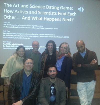
|
| Participants in The Art and Science Dating Game at the Metropolitan Museum of Art in New York City, March 27, 2013. Left to right in the back row, artist Eve Mosher, anthropologist Kenny Broad, moderator Nilda Mesa, Earth scientist Robin Bell, and MMA Artist in Residence Paul D. Miller, a.k.a. DJ Spooky. Left to right in front, geographer Robert Chen and artist Lars Jan. |
The opportunity for new collaborations between artists and scientists was the focus of a unique “dating game” held at the Metropolitan Museum of Art (MMA) in New York City on the evening of March 27. Three artists and three scientists, including CIESIN director Robert Chen and Lamont Doherty Earth Observatory scientist Robin Bell, were paired together to talk about their common interests and diverse approaches to visualization and communication. Chen appeared with Lars Jan, founding artistic director of Early Morning Opera, a multidisciplinary art lab based in Los Angeles specializing in live performance. Jan is currently working on a performance project called “Holoscenes” that will use human interactions with water as a medium of expression about environmental and cultural change around the world. The panel, moderated by Nilda Meesa of Columbia's School of Journalism, also included MMA's first Artist in Residence, Paul D. Miller, more widely known as DJ Spooky, who has recently authored The Book of Ice. The event was co-produced by the MMA and PositiveFeedback, an initiative of Columbia’s Earth Institute, the Center for Creative Research at New York University, and the Institute for Sustainable Cities of the City University of New York.
See: The Art and Science Dating Game: How Artists and Scientists Find Each Other
The Art and Science Dating Game: Photo Gallery
|
|
Expert Group Aims to Inform Sustainable Development Policymaking
|
|
March 22, 2013
CIESIN deputy director Marc Levy and associate research scientist Susana Adamo participated in an Expert Group Meeting (EGM) on Science and Sustainable Development Goals (SDGs) held March 20-21 at United Nations headquarters in New York City. Adamo chaired a portion of the meeting, and Levy served as rapporteur for one of the two break-out groups. Organized by the UN Department of Economic and Social Affairs (DESA) in partnership with the International Council for Science (ICSU) and the International Social Science Council (ISSC), the purpose of the meeting was to assess how science can best inform the SDG process and provide guidance to the Open Working Group on Sustainable Development Goals (OWG). The OWG is a body of the UN General Assembly charged with developing proposals for the SDGs, which are expected to guide international development efforts after 2015.
See: UN Sustainable Development Knowledge Platform
Concept Note--Interactive Discussion on SDGs
|
|
International Research Data Alliance Launched in Sweden
|
|
March 21, 2013
A new organization aimed at accelerating international data-driven innovation and discovery was launched March 18-20 in Gothenburg, Sweden. The Research Data Alliance (RDA) drew together more than 230 scientists, technologists, data managers, and other interested stakeholders from around the world to plan collaboration, discuss partnerships, and assess opportunities and challenges. CIESIN director Robert Chen participated in a panel on how the RDA could collaborate with other related organizations, such as CODATA, the Committee on Data for Science and Technology of the International Council for Science, for which he served as secretary-general from 2004-12. He is also a co-chair of a newly formed RDA interest group on legal interoperability of scientific data, and moderated a session on this topic during the meeting. The RDA launch was supported by sponsors from the European Commission and the U.S. and Australian governments.
See: Research Data Alliance
"United We Stand" Panel Agenda and Presentations
|
|
Visiting Scientists Complete Productive Terms at CIESIN
|
|
March 19, 2013
|
| Two visiting scholars with the CIESIN staff who helped host them, March 15, 2013, in front of the figurehead of the Lamont research vessel Vema. Left to right, senior research associate Alex de Sherbinin, visiting scientists Taro Ubukawa and Ruishan Chen, CIESIN director Robert Chen (no relation), and information scientist Xiaoshi Xing. |
CIESIN bid goodbye recently to two visiting scholars. Ruishan Chen, a PhD candidate in the College of Urban and Environmental Science and the Center for Land Study at Peking University in Beijing, came to CIESIN in September 2011. During his stay, he conducted independent research on land use transition, human migration, and its consequences in the Karst Areas of Southwestern China, including completion of his PhD dissertation. His paper, “Integrated Restoration of Small Watershed in Karst Regions,” was published in AMBIO: A Journal of the Human Environment published by the Royal Swedish Academy of Sciences. Another paper on rural out-migration and land use transition in China has been accepted by an international journal and two others are under review. Taro Ubukawa, chief of the Environmental Geoinformation Section in the Environmental Geography Division of the Geospatial Information Authority of Japan, was hosted by CIESIN for one year. He is a member of the CODATA Global Roads Data Development Task Group, led by CIESIN senior research associate Alex de Sherbinin, which aims to improve data on intercity road networks. Ubukawa's research focused on road extraction from remote sensing imagery, spatial accuracy assessment of Google and Bing imagery, and data development for the Global Roads Open Access Data Set (gROADS). Ubukawa holds an M.S. in metamorphic petrology and a B.S. in science from Kyoto University, and has worked extensively with the International Steering Committee for Global Mapping. The Geospatial Information Authority is part of Japan's Ministry of Land, Infrastructure, Transport and Tourism.
|
|
New Staff Members and Intern
|
|
March 15, 2013
CIESIN is pleased to welcome Erin Doxsey-Whitfield and Gina Dinnegan as staff members and Jared Talkin as an intern. Doxsey-Whitfield is now a senior research staff assistant in the Geospatial Applications Division, after working at CIESIN last year as a casual employee. She received a M.S. in physical geography from Queen's University in Kingston, Ontario, where her research focused on glacial biogeochemistry and alpine water quality. Dinnegan has joined CIESIN's administrative team as a part-time administrative assistant. She had been a teacher’s assistant at St. Dominic’s School in Blauvelt, New York, working with special education students. Talkin is majoring in sustainable development at Columbia's School of General Studies and is a senior editor of Consilience, The Journal of Sustainable Development, hosted by the Columbia Libraries. At CIESIN, he is working on the fourth version of the Gridded Population of the World data product.
|
|
Training on Geospatial Metadata Management Provided in Ethiopia
|
|
March 12, 2013
CIESIN geographic information specialist Malanding Jaiteh visited Addis Ababa, Ethiopia, February 24-28 to conduct training on managing geospatial metadata sponsored by the Ethiopia Agricultural Transformation Agency (ATA). The training session, held at the National Soil Testing Center (NSTC), included 17 geographic information systems and information technology staff from 12 Ethiopian federal and regional agencies. The training program is a collaboration between the Africa Soils Information Service (AfSIS), Ethiopia ATA, CIESIN, and the International Research Institute for Climate and Society (IRI). Sound management of digital data needed for agriculture and management of natural resources is essential to improving agricultural planning and practices in developing countries. Training topics included an introduction to geospatial metadata; commercial and open source metadata development tools; GeoNetwork Opensource as a geospatial metadata cataloging and development tool; and the role of metadata in national spatial data infrastructure.
|
|
Annual Message from the Director: Two Decades Later
|
|
March 11, 2013
|
| CIESIN moved to the Lamont Campus of Columbia University in Palisades, New York, in July 1998, becoming a center in the newly established Earth Institute along with the International Research Institute on Climate and Society (IRI). |
In late 1992, I received a call from a head hunter who was seeking suggestions for a senior scientist with a non-profit organization that had an odd acronym and long name: CIESIN, the Consortium for International Earth Science Information Network, based in Saginaw, Michigan. Although not senior myself, I thought I had a lot of the desired interdisciplinary expertise and experience already—in part from working with geographer Bob Kates as an assistant professor with the Alan Shawn Feinstein World Hunger Program at Brown University—so I applied for the position. After a short period working as a consultant, I began at CIESIN fulltime in March 1993, the same month that Dr. Roberta Balstad Miller took over as CIESIN’s second president. The Science Division I joined was directed by the late Jack Eddy, a noted space scientist with whom I had worked on a National Research Council study for the International-Geosphere Biosphere Program. In the first few years, we had the opportunity to launch some exciting new activities, including a Global Demography Project proposed by distinguished geographer Waldo Tobler and some innovative online data resources such as the Environmental Treaties and Resource Indicators (ENTRI) database and the China Dimensions data collection. With the Internet and the World Wide Web still in their early stages, CIESIN was ahead of the curve in bringing new data and information technologies to bear on interdisciplinary problems involving both the natural and social sciences. Full Story
|
|
CIESIN Director Robert Chen Joins Science Advisory Board of Oak Ridge Institute
|
|
March 8, 2013
The Climate Change Science Institute (CCSI) is an interdisciplinary, cross-directorate research organization created in 2009 at the Oak Ridge National Laboratory (ORNL) in Oak Ridge, Tennessee. CIESIN director Robert Chen was appointed to a three-year term on the CCSI Science Advisory Board in late 2012 and participated in the annual meeting of the Board March 6–7 in Oak Ridge. Chaired by Prof. Sara Graves of the University of Alabama at Huntsville, the Board advises the CCSI on its strategic science objectives, which encompass work in Earth system modeling; data integration, dissemination, and informatics; terrestrial ecosystem and carbon cycle science; and impacts, adaptation, and vulnerability science. Oak Ridge National Laboratory is managed by UT-Battelle, LLC for the U.S. Department of Energy.
See: Climate Change Science Institute (CCSI)
|
|
CIESIN Deputy Director Assists in Selecting Fulbright Public Policy Fellows
|
|
March 8, 2013
CIESIN deputy director Marc Levy served on the National Selection Committee for the Public Policy Fulbright Fellowship, which convened at the Institute of International Education (IIE) in New York City March 8. The awards, to U.S. graduate students, will place Fellows as a special assistant to a senior level official of a foreign government ministry or institution, in order to gain hands-on public sector experience in participating foreign countries while simultaneously carrying out an academic research/study project. Participating countries for the 2013–14 academic year include Bangladesh, Burma, Dominican Republic, Ethiopia, Guatemala, Haiti, Ivory Coast, Kazakhstan, Malawi, Nepal, and Samoa. The Fulbright Awards are conducted annually by IIE; this is the second year that Public Policy Fellowships are being offered.
See: Fulbright U.S. Student Program
|
|
Geoscience Education Needs Considered at EarthCube Workshop
|
|
March 7, 2013
CIESIN senior digital archivist Robert Downs participated in the EarthCube Education End-User Workshop, which was held at the University of California, San Diego, Scripps Institution of Oceanography March 4–6. Sponsored by the National Science Foundation (NSF), the workshop focused on tools and capabilities for improving undergraduate education in the Earth and environmental sciences. It included scientist-educators, data providers, and employers. Downs gave a presentation highlighting interdisciplinary uses of SEDAC data and he served as a facilitator of a breakout session on Interface Design. EarthCube is a collaborative endeavor between NSF and the community of geoscientists and cyberscientists to transform research and data management practices and provide new access and visualization capabilities to the geosciences community over the next decade.
See: EarthCube Education End-User Workshop
|
|
CIESIN Helps Launch Indicator-Based Assessment of Transboundary Waters
|
|
March 6, 2013
The Transboundary Waters Assessment Programme (TWAP) River Basins kickoff workshop took place March 4–5 in Copenhagen, with CIESIN senior research associate Alex de Sherbinin presenting a summary of the SEDAC data sets relevant to the assessment. Funded by the Global Environmental Facility (GEF), TWAP is an indicator-based global assessment of all transboundary freshwater and marine systems, including physical, socioeconomic, and governance aspects. CIESIN's primary role is to develop socioeconomic indicators based on a range of data sets for approximately 260 transboundary river basins globally.
See: TWAP
|
|
Advances in Research Data Management Highlighted at Columbia Symposium
|
|
February 28, 2013
A variety of new data management tools and services aimed at improving the quality, accessibility, and preservation of scientific data were featured in a one-day Research Data Symposium held February 27 at Columbia University’s Faculty House in New York. The Symposium began with a keynote address by noted open access pioneer Peter Murray-Rust of the University of Cambridge. Four panels of speakers then addressed innovative activities supporting different stages of the data management life cycle, including services to facilitate data documentation, discovery, citation, long-term preservation, and assessment of impact. Senior digital archivist Robert Downs served as a respondent on a panel focused on assuring, describing, and preserving research data. CIESIN director Robert Chen closed the symposium, emphasizing the importance of long-term collaboration between universities and their libraries, government, the private sector, and the research community. Downs and Chen also contributed a poster paper on data stewardship and a second poster on citation of interdisciplinary data co-authored with senior information specialist Joe Schumacher. Organized by the Columbia Libraries, Elsevier, and Columbia's new Institute for Data Sciences and Engineering, the Symposium drew more than 200 participants to the Columbia campus. Many others from around the world followed the Symposium via a live Web cast and Twitter. Video of the Symposium is available via ustream.
See: Columbia Research Data Symposium
|
|
New Mapping Tool to Identify Flood Risk for the Hudson Valley
|
|
February 22, 2013
As demonstrated by Hurricane Irene and Superstorm Sandy, the Northeast and the Hudson Valley are highly vulnerable to storm surge and heavy rainfall events. Even conservative estimates of future rises in sea level associated with climate change indicate that the frequency and severity of storm-driven floods could increase significantly. A new grant from the New York State Energy Research and Development Authority (NYSERDA) will support development of a flood assessment mapping tool for the lower Hudson Valley region. The Hudson River Flood Hazard Decision Support System will be a free, easy to use, online resource that will allow users to assess the impacts of flood inundation posed by sea level rise, storm surge, and rain events on communities bordering the lower Hudson River. It will be based on a flood inundation model developed by researchers from the Stevens Institute of Technology. The mapping tool will help public officials, resource managers, and others assess risk and plan flood mitigation efforts. The project kick off meeting was held February 22 at CIESIN with members of the Project Advisory Committee, which includes representatives from relevant local, state, and federal government agencies, non-profit groups, and academic institutions. Associate Director for Geospatial Applications Mark Becker is the principal investigator of the project and hosted the meeting along with NYSERDA and the project team from CIESIN and Stevens.
|
|
National Soil Information System Under Development in Ethiopia
|
|
February 22, 2013
CIESIN operations manager Hans Bosch traveled to Ethiopia recently to supervise the set up of hardware and software for a computerized national soil management system under the auspices of the Ethiopia Soil Information Service (EthioSIS) and the Africa Soil Information Service (AfSIS). The implementation took place February 6–14 at the Ministry of Agriculture and the National Soil Testing Laboratory in Addis Ababa. The new system will support data storage, processing, analysis, and distribution of soil property maps for EthioSIS and AfSIS, collaborative projects between the Earth Institute and African scientists and institutions. AfSIS aims to develop continent-wide digital soil maps for sub-Saharan Africa using innovative soil analysis and statistical methods. The project is funded by the Bill & Melinda Gates Foundation and the Alliance for a Green Revolution in Africa.
|
|
International Sharing of Data Addressed in Brussels Meeting
|
|
February 16, 2013
CIESIN director Robert Chen participated in a working meeting hosted February 11–12 in Brussels by the European Commission and organized by the Data Sharing Working Group (DSWG) of the Group on Earth Observations (GEO). The DSWG is the focal point within GEO for implementation of the Global Earth Observing System of Systems (GEOSS) Data Sharing Principles, and in particular the Data Sharing Action Plan approved at the 2010 GEO Ministerial Summit. Chen is one of the DSWG co-chairs, representing the International Council for Science, a GEO Participating Organization. He is also co-leading a new DSWG subgroup focused on encouraging more open data sharing environments and building capacity for data sharing at the national level. The working meeting included co-chairs and representatives from a number of GEO Members including the European Commission, Japan, the Netherlands, South Africa, the United Kingdom, and the United States.
|
|
Topics on Climate Change in West Africa Presented in Uganda and Ghana
|
|
February 14, 2013
Associate research scientist Sylwia Trzaska travelled to Kampala, Uganda Jan 28–Feb 1 as part of a team from the African and Latin American Resilience to Climate Change (ARCC) project presenting results of an assessment of Ugandan agriculture and food security vulnerability to climate change. The team also led a one-day workshop on Adaptation Option Analysis with more than 50 participants from Ugandan government and research institutions, international development agencies and donors. Funded by the U.S. Agency for International Development (USAID), the ARCC project is providing technical, analytic, and project assistance, as well as capacity building, to improve the ability of vulnerable populations to respond to climate challenges and safeguard economic growth in Africa and Latin America. Trzaska then visited Accra, Ghan,a to participate in two USAID workshops where she gave presentations on the “Reliability of Climate Projections in Africa” and “Climate Change in West Africa.”
|
|
Recent Staff Changes at CIESIN
|
|
February 8, 2013
CIESIN is pleased to welcome Linda Pistolesi as a full-time geographic information specialist in the Geospatial Applications Division (GAD). Pistolesi has worked at Columbia for more than 15 years, most recently dividing her time between CIESIN and the Department of Earth and Environmental Sciences (DEES). She is currently a Master′s candidate in the Department of Geography at Hunter College, where she is using synthetic aperture radar data to map wetlands in the Hudson Highlands. Pistolesi has a bachelor's degree from DEES and a Certificate in Conservation Biology and Environmental Policy from the Center for Environmental Research and Conservation. In other staff changes, geographic information specialist Kytt MacManus has been promoted to senior staff associate in GAD. MacManus is an adjunct lecturer at Columbia’s School of International and Public Affairs (SIPA) and has recently been elected to a three-year term on the Steering Committee of the Environmental Consortium of Hudson Valley Colleges and Universities. He received a Masters of Science degree in environmental policy from Bard College and a bachelor's degree in political science from Northeastern University. CIESIN departmental administrator Ellen Foy has also received a promotion, to senior business manager. Foy joined CIESIN in 2009, after previous administrative positions at Columbia and prior to that, as a management analyst for the federal government. She has a master's degree in business from CW Post-Long Island University.
|
|
NASA Socioeconomic Data and Applications Center Improves Access to Interdisciplinary Data and Maps
|
|
February 1, 2013
A unique source of interdisciplinary data on people and the environment is the Socioeconomic Data and Applications Center (SEDAC), operated by CIESIN as part of NASA’s Earth Observing System Data and Information System (EOSDIS). SEDAC works to enhance the value of NASA’s remote sensing data and information by disseminating complementary socioeconomic and environmental data and creating value-added integrated data products and services, including a wide variety of ready-to-use maps and mapping tools. With more than 40,000 unique visitors per month on average, SEDAC’s Web site provides a central access point for SEDAC data, information, tools, and other resources. A major redesign over the past year has greatly streamlined the user interface and improved access to SEDAC’s diverse holdings of spatial and other data and associated documentation. The most recent release includes a major upgrade to the search interface for SEDAC’s map collection, which contains more than 2,000 pre-formatted maps, all available openly under a Creative Commons-Attribution Only license. The Web site has also been improved in response to a recent usability review conducted by a leading user experience research firm commissioned by NASA. SEDAC’s data, which cover topics ranging from population distribution to natural disaster risk to environmental sustainability, are available to users for free via direct download and in many cases via database queries or map services compliant with open standards. SEDAC also provides users with assistance by e-mail or telephone, as well as examples of the use of SEDAC data in research and real-world applications. Feedback on the new Web site and on SEDAC’s holdings may be submitted online.
See: SEDAC Web site
|
|
Climate Vulnerability, Adaptation, and Data Integration Focus of Meetings in India
|
|
February 1, 2013
CIESIN senior research associate Alex de Sherbinin travelled to Goa and Mumbai, India recently for talks and meetings on climate vulnerability and adaptation and on data management and integration. On January 25 he gave a presentation on “Climate Change Vulnerability & Adaptation at the Urban Scale: Spatial Knowledge and Policy Research” to the Goa Town and County Planning Association. For a data management workshop associated with the Integrated Marine Biogeochemistry and Ecosystem Research (IMBER) program on January 27, he presented “Social science data management and data integration for global change research.” The workshop was held at India’s National Institute of Oceanography in Goa. From January 29–February 1, de Sherbinin served as visiting scholar at the Indian Institute of Technology (IIT-Bombay) in Mumbai. There he gave talks on climate vulnerability and adaptation and on the integration of remote sensing and social science data. He also held meetings with IIT-Bombay colleagues and city officials related to planned research on flood vulnerability in Mumbai.
|
|
Governance and Climate Change Scenarios Among the Topics at Tokyo Conference
|
|
January 31, 2013
CIESIN deputy director Marc Levy participated in a series of meetings in Tokyo, on the occasion of the Earth Systems Governance conference held at United Nations University headquarters. On January 28 he helped lead a workshop on governance and climate change scenarios, under the auspices of the Joint IAV-IAM Committee on Development and Use of Socio-Economic Scenarios and the Earth System Governance Project. The workshop provided an opportunity to critically evaluate the role of governance in climate scenarios. Levy also gave a “semi-plenary” talk on this topic at the conference, on January 30. Finally, he participated in the launch of a project on Governance and the Sustainable Development Goals, to be carried out under the joint auspices of the UN University and the Earth Systems Governance Project with financial support by the Japanese Ministry of the Environment.
|
|
Limited CIESIN Availability January 18-21 Due to Planned Power Shutdown
|
|
January 14, 2013
A number of CIESIN web sites and services will be temporarily unavailable or have reduced functionality beginning Friday, January 18 due to a planned upgrade of the electrical system for the Geoscience Building, which houses CIESIN's main computer facilities at the Lamont campus of Columbia University. The power shutdown is expected to last until Sunday, January 20. CIESIN plans to return services to normal operation by late Monday, January 21, which is the Martin Luther King, Jr. holiday in the U.S. when Columbia University is normally closed. CIESIN offices will be closed beginning at noon on Friday. However, many staff members will be working from other locations and accessible via electronic mail. Any urgent requests should be sent to CIESIN User Services at ciesin.info@ciesin.columbia.edu. We apologize in advance for any inconvenience.
|
|
Maps Depict Data Related to Climate Change Loss and Damage
|
|
January 11, 2013
CIESIN has contributed to a new report by the Loss and Damage in Vulnerable Countries Initiative of the United Nations University. The report, Evidence from the Frontlines of Climate Change: Loss and Damage to Communities Despite Coping and Adaptation, summarizes research on how the impact of climate change on society leads to livelihood and infrastructure losses and economic damages among vulnerable households in the developing world. Case studies were carried out in five countries: Bangladesh, Bhutan, the Gambia, Kenya, and Micronesia. CIESIN created maps for the case studies that visualize climate change impacts such as cyclones and floods as well as baseline conditions such as poverty or land use systems. For example, maps of Bangladesh highlight loss and damage associated with salinity intrusion and vulnerability to storm surges caused by cyclones, elevation, and poverty. A map of Bhutan illustrates loss and damage associated with changing storm surge severity.
See: Evidence from the Frontlines of Climate Change: Loss and Damage to Communities Despite Coping and Adaptation (6.32 MB PDF)
|
|
Advancing Earth Science Information is Theme of Washington DC Meeting
|
|
January 10, 2013
Data Center Services manager John Scialdone and senior digital archivist Robert Downs represented the NASA Socioeconomic Data and Applications Center (SEDAC) at the 2013 Winter Meeting of the Federation of Earth Science Information Partners (ESIP), held January 8–10 in Washington DC. Downs co-organized the Open Source Cluster Breakout on January 8 with Chris Mattmann of the NASA Jet Propulsion Laboratory, and presented “Highlights of the Earth Science Data System (ESDS) Software Reuse Working Group” during this session. He also presented the poster, “Improving Open Scientific Data Practices: Lessons from Open Source Software.” Scialdone was re-elected as chair the ESIP Federation Partnership Committee, whose function is to review and approve organizations applying for membership, and Downs was re-appointed as a member of the Ontology Governance Group for the ESIP Semantic Web Cluster. The winter meeting focused on the theme, “Advancing Earth Science Information: From Climate Assessment to Intelligence to Action.”
|
|
Collaboration Established with Leading Indian Economic Research Firm
|
|
January 7, 2013
CIESIN and Indicus Analytics Pvt. Ltd, an economic research firm based in New Delhi, India, have recently signed a letter of agreement to collaborate on research activities of mutual interest, focusing in particular on the study of human settlement patterns, hazard monitoring and prediction, and environmental performance metrics and assessment. Established in 2000, Indicus conducts both commissioned and non-commissioned studies across economic, socio-demographic, business, and consumer market domains for both public and private sector sponsors. The planned collaboration will build on existing CIESIN and Indicus activities related to the use of remote sensing and spatial data in disaster risk assessment, development of environmental performance indicators, and monitoring of demographic and environmental conditions. Indicus director Laveesh Bhandari visited CIESIN in November 2012 and is planning to meet with senior research associate Alex de Sherbinin in Bombay in January 2013.
See: Indicus Analytics Pvt. Ltd
|
|
NASA Earth Science Research and Data Featured in New Publication
|
|
January 4, 2013
Twelve new articles on the use of NASA remote sensing data and information in Earth science research are featured in the 2012 version of Sensing Our Planet, an annual collection prepared by the National Snow and Ice Data Center on behalf of the NASA Earth Observing Data and Information System (EOSDIS). The articles highlight a wide variety of natural and social science research activities enabled by access to Earth observations and related data from EOSDIS. In one article, former CIESIN staff member Adam Storeygard, now an assistant professor of economics at Tufts University, discusses his use of night-time lights and population data to better estimate economic activity around the world over recent decades. He and his colleagues Vernon Henderson and David Weil from Brown University obtained the data from the National Geophysical Data Center (NGDC) in Boulder and the NASA Socioeconomic Data and Applications Center (SEDAC) operated by CIESIN. The 2012 collection is available for free, both in print and online.
See: Sensing Our Planet 2012
|
|
New Book Highlights Use of Environmental Data in Public Health Applications
|
|
January 3, 2013
A new book on Environmental Tracking for Public Health Surveillance has been released as part of the International Society for Photogrammetry and Remote Sensing (ISPRS) Book Series published by CRC Press. Edited by Stanley A. Morain and Ameilia M. Budge of the University of New Mexico, the volume includes a range of papers on the use of Earth observations and other geospatial environmental and socioeconomic data in public health applications. CIESIN senior research associate Meredith Golden and director Robert Chen contributed to a chapter, “Data discovery, access and retrieval,” prepared by Steve Kempler of the NASA Goddard Space Flight Center. This chapter highlights the many data resources and services relevant to public health available from a variety of sources, including the NASA Socioeconomic Data and Applications Center (SEDAC) and the Columbia Superfund Research Program Web site, both operated by CIESIN. The volume is the 11th in the ISPRS Book Series, which began in 2004.
|
|